Bridge Statistics for Kutztown, Pennsylvania (PA)
Condition, Traffic, Stress, Structural Evaluation, Project Costs
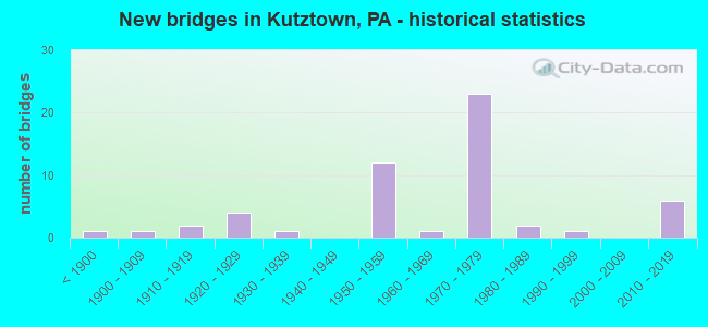
- New bridges - historical statistics
- 1Before 1900
- 11900-1909
- 21910-1919
- 41920-1929
- 11930-1939
- 121950-1959
- 11960-1969
- 231970-1979
- 21980-1989
- 11990-1999
- 62010-2019

- Reconstructed bridges - Historical Statistics
- 11950-1959
- 21960-1969
- 21970-1979
- 01980-1989
- 01990-1999
- 52000-2009
- 32010-2019


- Bridge Condition - Deck
- 12.5%Very good
- 31.3%Good
- 31.3%Satisfactory
- 15.6%Fair
- 9.4%Poor

- Bridge Condition - Superstructure
- 2.9%Excellent
- 11.8%Very good
- 20.6%Good
- 29.4%Satisfactory
- 29.4%Fair
- 2.9%Poor
- 2.9%Serious

- Bridge Condition - Substructure
- 5.9%Very good
- 26.5%Good
- 32.4%Satisfactory
- 26.5%Fair
- 8.8%Poor

- Bridge Condition - Channel
- 13.0%Very good
- 8.7%Good
- 13.0%Satisfactory
- 47.8%Fair
- 17.4%Poor

- Bridge Condition - Culverts
- 50.0%Good
- 50.0%Satisfactory
Find on map >> Show street view
Structure Number: 4802, Location: 1 MI SW OF KUTZTOWN (Lat: 40.522167, Lng: -75.789275), Route carried "under" structure: City street , Year Built: 1972, Structure Length: 0. m, Average Daily Traffic: 200 (year 1994), Truck Traffic: 1%, Features Intersected: T-606(SHARADIN RD.), Facility Carried by Structure: US 222 SB(LR 157)
Minimum Vertical Clearance: 4.50m (14.76ft), Kilometerpoint: 0.000, Lanes on structure: 2, Lanes under structure: 2, Material/Design: Prestressed concrete, Design/Construction: Stringer/Multi-beam, Length of Maximum Span: 28.0m (91.9ft)
Find on map >> Show street view
Structure Number: 4803, Location: KUTZTOWN BOROUGH LINE (Lat: 40.521044, Lng: -75.789403), Route carried "under" structure: City street , Year Built: 1972, Structure Length: 0. m, Average Daily Traffic: 122 (year 1994), Truck Traffic: 5%, Features Intersected: T-798(COLLEGE BLVD.), Facility Carried by Structure: SR 222 NB(LR 157)
Minimum Vertical Clearance: 4.42m (14.50ft), Kilometerpoint: 0.000, Lanes on structure: 2, Lanes under structure: 2, Material/Design: Prestressed concrete, Design/Construction: Stringer/Multi-beam, Length of Maximum Span: 30.5m (100.1ft)
Find on map >> Show street view
Structure Number: 4804, Location: KUTZTOWN BOROUGH LINE (Lat: 40.521350, Lng: -75.789669), Route carried "under" structure: City street , Year Built: 1972, Structure Length: 0. m, Average Daily Traffic: 122 (year 1994), Truck Traffic: 5%, Features Intersected: T-798(COLLEGE BLVD.), Facility Carried by Structure: SR 222 SB(LR 157)
Minimum Vertical Clearance: 4.36m (14.30ft), Kilometerpoint: 0.000, Lanes on structure: 2, Lanes under structure: 2, Material/Design: Prestressed concrete, Design/Construction: Stringer/Multi-beam, Length of Maximum Span: 30.5m (100.1ft)
Find on map >> Show street view
Structure Number: 4806, Location: PA737 EXIT (Lat: 40.531250, Lng: -75.766403), Route carried "under" structure: State highway 737, Year Built: 1972, Structure Length: 0. m, Average Daily Traffic: 2,577 (year 2020), Truck Traffic: 13%, Features Intersected: PA 737(LR 06134), Facility Carried by Structure: US 222 NB(LR 157)
Minimum Vertical Clearance: 4.60m (15.09ft), Kilometerpoint: 0.000, Lanes on structure: 3, Lanes under structure: 2, Material/Design: Steel, Design/Construction: Stringer/Multi-beam, Length of Maximum Span: 35.1m (115.2ft)
Find on map >> Show street view
Structure Number: 4806, Location: PA737 EXIT (Lat: 40.531250, Lng: -75.766403), Route carried "under" structure: State highway 737, Year Built: 1972, Structure Length: 0. m, Average Daily Traffic: 2,577 (year 2020), Truck Traffic: 13%, Features Intersected: PA 737(LR 06134), Facility Carried by Structure: US 222 NB(LR 157)
Minimum Vertical Clearance: 5.09m (16.70ft), Kilometerpoint: 0.000, Lanes on structure: 3, Lanes under structure: 2, Material/Design: Steel, Design/Construction: Stringer/Multi-beam, Length of Maximum Span: 35.1m (115.2ft)
Find on map >> Show street view
Structure Number: 4808, Location: PA737 EXIT (Lat: 40.531417, Lng: -75.767483), Route carried "under" structure: State highway 737, Year Built: 1972, Structure Length: 0. m, Average Daily Traffic: 2,577 (year 2020), Truck Traffic: 13%, Features Intersected: PA 737(LR 06134), Facility Carried by Structure: US 222 SB(LR 157)
Minimum Vertical Clearance: 4.75m (15.58ft), Kilometerpoint: 0.000, Lanes on structure: 3, Lanes under structure: 2, Material/Design: Steel, Design/Construction: Stringer/Multi-beam, Length of Maximum Span: 35.1m (115.2ft)
Find on map >> Show street view
Structure Number: 4808, Location: PA737 EXIT (Lat: 40.531417, Lng: -75.767483), Route carried "under" structure: State highway 737, Year Built: 1972, Structure Length: 0. m, Average Daily Traffic: 2,577 (year 2020), Truck Traffic: 13%, Features Intersected: PA 737(LR 06134), Facility Carried by Structure: US 222 SB(LR 157)
Minimum Vertical Clearance: 5.27m (17.29ft), Kilometerpoint: 0.000, Lanes on structure: 3, Lanes under structure: 2, Material/Design: Steel, Design/Construction: Stringer/Multi-beam, Length of Maximum Span: 35.1m (115.2ft)
Find on map >> Show street view
Structure Number: 4809, Location: N.ELM ST OVER US 222 (Lat: 40.530431, Lng: -75.770744), Route carried "under" structure: US 222, Year Built: 1972, Structure Length: 0. m, Average Daily Traffic: 10,124 (year 2020), Truck Traffic: 21%, Features Intersected: US 222(LR 157), Facility Carried by Structure: SR 1055(N.ELM ST.)
Minimum Vertical Clearance: 5.88m (19.29ft), Kilometerpoint: 44.629, Lanes on structure: 2, Lanes under structure: 4, Material/Design: Steel continuous, Design/Construction: Stringer/Multi-beam, Length of Maximum Span: 36.6m (120.1ft)
Find on map >> Show street view
Structure Number: 4809, Location: N.ELM ST OVER US 222 (Lat: 40.530431, Lng: -75.770744), Route carried "under" structure: US 222, Year Built: 1972, Structure Length: 0. m, Average Daily Traffic: 9,731 (year 2020), Truck Traffic: 22%, Features Intersected: US 222(LR 157), Facility Carried by Structure: SR 1055(N.ELM ST.)
Minimum Vertical Clearance: 4.82m (15.81ft), Kilometerpoint: 44.708, Lanes on structure: 2, Lanes under structure: 4, Material/Design: Steel continuous, Design/Construction: Stringer/Multi-beam, Length of Maximum Span: 36.6m (120.1ft)
Find on map >> Show street view
Structure Number: 481, Location: NORTH END OF BYPASS (Lat: 40.531100, Lng: -75.760558), Route carried "under" structure: Ramp State highway , Year Built: 1972, Structure Length: 0. m, Average Daily Traffic: 2,442 (year 2022), Truck Traffic: 7%, Features Intersected: SR 8015(RAMP G), Facility Carried by Structure: US 222 NB(LR157)
Minimum Vertical Clearance: 5.31m (17.42ft), Kilometerpoint: 0.000, Lanes on structure: 2, Lanes under structure: 1, Material/Design: Steel, Design/Construction: Stringer/Multi-beam, Length of Maximum Span: 32.9m (107.9ft)
Find on map >> Show street view
Structure Number: 2299, Location: NEW SMITHVILLE (Lat: 40.579669, Lng: -75.731331), Route carried "under" structure: State highway , Year Built: 1958, Structure Length: 0. m, Average Daily Traffic: 1,453 (year 2022), Truck Traffic: 14%, Features Intersected: T-501(OLD 22), Facility Carried by Structure: I 78(LR 443)
Minimum Vertical Clearance: 5.00m (16.40ft), Kilometerpoint: 1.019, Lanes on structure: 4, Lanes under structure: 2, Material/Design: Steel continuous, Design/Construction: Stringer/Multi-beam, Length of Maximum Span: 28.0m (91.9ft)
Find on map >> Show street view
Structure Number: 53612, Location: KRUMSVILLE INTERCHANGE (Lat: 40.577314, Lng: -75.798181), Route carried "under" structure: Interstate 78, Year Built: 2016, Structure Length: 0. m, Average Daily Traffic: 20,640 (year 2022), Truck Traffic: 30%, Features Intersected: I-78 (LR285SP), Facility Carried by Structure: PA 737 (LR06134)
Minimum Vertical Clearance: 5.93m (19.46ft), Kilometerpoint: 50.950, Lanes on structure: 3, Lanes under structure: 2, Material/Design: Steel, Design/Construction: Stringer/Multi-beam, Length of Maximum Span: 68.0m (223.1ft)
Find on map >> Show street view
Structure Number: 53612, Location: KRUMSVILLE INTERCHANGE (Lat: 40.577314, Lng: -75.798181), Route carried "under" structure: Interstate 78, Year Built: 2016, Structure Length: 0. m, Average Daily Traffic: 20,763 (year 2022), Truck Traffic: 28%, Features Intersected: I-78 (LR285SP), Facility Carried by Structure: PA 737 (LR06134)
Minimum Vertical Clearance: 5.23m (17.16ft), Kilometerpoint: 50.929, Lanes on structure: 3, Lanes under structure: 2, Material/Design: Steel, Design/Construction: Stringer/Multi-beam, Length of Maximum Span: 68.0m (223.1ft)