Bridge Statistics for Lisle, Illinois (IL)
Condition, Traffic, Stress, Structural Evaluation, Project Costs
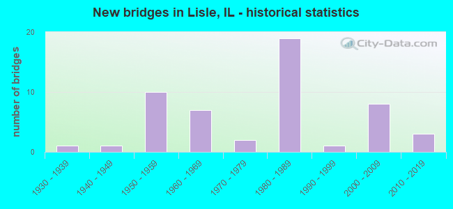
- New bridges - historical statistics
- 11930-1939
- 11940-1949
- 101950-1959
- 71960-1969
- 21970-1979
- 191980-1989
- 11990-1999
- 82000-2009
- 32010-2019

- Reconstructed bridges - Historical Statistics
- 11970-1979
- 51980-1989
- 21990-1999
- 12000-2009
- 12010-2019


- Bridge Condition - Deck
- 10.0%Very good
- 26.7%Good
- 43.3%Satisfactory
- 16.7%Fair
- 3.3%Serious

- Bridge Condition - Superstructure
- 18.2%Very good
- 27.3%Good
- 30.3%Satisfactory
- 21.2%Fair
- 3.0%Serious

- Bridge Condition - Substructure
- 18.2%Very good
- 54.5%Good
- 24.2%Satisfactory
- 3.0%Fair

- Bridge Condition - Channel
- 5.3%Excellent
- 10.5%Very good
- 42.1%Good
- 10.5%Satisfactory
- 26.3%Fair
- 5.3%Poor

- Bridge Condition - Culverts
- 33.3%Good
- 33.3%Satisfactory
- 33.3%Fair
Find on map >> Show street view
Structure Number: 229922, Location: 0.9 M W OF ILL 53 (Lat: 41.805478, Lng: -88.091328), Route carried "under" structure: Other road , Year Built: 1958, Structure Length: 0. m, Average Daily Traffic: 6,600 (year 2020), Truck Traffic: 5%, Features Intersected: YACKLEY AVENUE, Facility Carried by Structure: I-88 EB
Minimum Vertical Clearance: 4.34m (14.24ft), Kilometerpoint: 0.290, Lanes on structure: 2, Lanes under structure: 2, Toll: On toll road, Material/Design: Prestressed concrete continuous, Design/Construction: Girder and Floorbeam System, Length of Maximum Span: 21.0m (68.9ft)
Find on map >> Show street view
Structure Number: 229923, Location: 0.9M W OF ILL 53 (Lat: 41.805697, Lng: -88.091336), Route carried "under" structure: Other road , Year Built: 1958, Structure Length: 0. m, Average Daily Traffic: 6,600 (year 2020), Truck Traffic: 5%, Features Intersected: YACKLEY AVENUE, Facility Carried by Structure: I-88 WB
Minimum Vertical Clearance: 4.34m (14.24ft), Kilometerpoint: 0.274, Lanes on structure: 2, Lanes under structure: 2, Toll: On toll road, Material/Design: Prestressed concrete continuous, Design/Construction: Stringer/Multi-beam, Length of Maximum Span: 21.0m (68.9ft)
Find on map >> Show street view
Structure Number: 229972, Location: 0.4 M.N. OF US-34 (Lat: 41.810053, Lng: -88.049733), Route carried "under" structure: Interstate 355, Year Built: 1989, Structure Length: 0. m, Average Daily Traffic: 71,900 (year 2020), Truck Traffic: 18%, Features Intersected: I-355, Facility Carried by Structure: I-88
Minimum Vertical Clearance: 4.88m (16.01ft), Kilometerpoint: 32.749, Lanes on structure: 8, Lanes under structure: 6, Toll: On toll road, Material/Design: Prestressed concrete continuous, Design/Construction: Stringer/Multi-beam, Length of Maximum Span: 42.4m (139.1ft)
Find on map >> Show street view
Structure Number: 229973, Location: 0.45 M.N. OF US-34 (Lat: 41.810072, Lng: -88.055103), Route carried "under" structure: Other road , Year Built: 1989, Structure Length: 0. m, Average Daily Traffic: 17,800 (year 2020), Truck Traffic: 14%, Features Intersected: I-355 NB TO I-88 WB, Facility Carried by Structure: I-88
Minimum Vertical Clearance: 4.90m (16.08ft), Kilometerpoint: 0.563, Lanes on structure: 7, Lanes under structure: 1, Toll: On toll road, Material/Design: Concrete, Design/Construction: Slab, Length of Maximum Span: 109.7m (359.9ft)
Find on map >> Show street view
Structure Number: 229974, Location: 1.2 M.E. OF IL-53 (Lat: 41.807806, Lng: -88.053269), Route carried "under" structure: Interstate 355, Year Built: 1989, Structure Length: 0. m, Average Daily Traffic: 115,900 (year 2020), Truck Traffic: 13%, Features Intersected: I-355
Minimum Vertical Clearance: 4.88m (16.01ft), Kilometerpoint: 32.315, Lanes on structure: 8, Lanes under structure: 1, Toll: On toll road, Material/Design: Steel, Design/Construction: Stringer/Multi-beam, Length of Maximum Span: 40.5m (132.9ft)
Find on map >> Show street view
Structure Number: 229974, Location: 1.2 M.E. OF IL-53 (Lat: 41.807725, Lng: -88.053622), Route carried "under" structure: Other road , Year Built: 1989, Structure Length: 0. m, Average Daily Traffic: 4,100 (year 2020), Truck Traffic: 9%, Features Intersected: I-355, Facility Carried by Structure: I-355 NB TO I-88 W
Minimum Vertical Clearance: 6.10m (20.01ft), Kilometerpoint: 0.145, Lanes on structure: 8, Lanes under structure: 1, Toll: On toll road, Material/Design: Steel, Design/Construction: Stringer/Multi-beam, Length of Maximum Span: 40.5m (132.9ft)
Find on map >> Show street view
Structure Number: 229975, Location: 1.0 M.E. OF IL-53 (Lat: 41.807806, Lng: -88.053269), Route carried "under" structure: Interstate 355, Year Built: 1989, Structure Length: 0. m, Average Daily Traffic: 115,900 (year 2020), Truck Traffic: 13%, Features Intersected: I-355 & RAMPS, Facility Carried by Structure: WARRENVILLE RD
Minimum Vertical Clearance: 5.03m (16.50ft), Kilometerpoint: 32.315, Lanes on structure: 4, Lanes under structure: 6, Material/Design: Steel continuous, Design/Construction: Stringer/Multi-beam, Length of Maximum Span: 42.7m (140.1ft)
Find on map >> Show street view
Structure Number: 229976, Location: 1.1 M.E. OF IL-53 (Lat: 41.806800, Lng: -88.054694), Route carried "under" structure: Other road , Year Built: 1989, Structure Length: 0. m, Average Daily Traffic: 4,100 (year 2020), Truck Traffic: 9%, Features Intersected: I-355 SB TO US-34, Facility Carried by Structure: I-88 EB TO I-355 S
Minimum Vertical Clearance: 4.88m (16.01ft), Kilometerpoint: 0.290, Lanes on structure: 1, Lanes under structure: 1, Toll: On toll road, Material/Design: Prestressed concrete, Design/Construction: Stringer/Multi-beam, Length of Maximum Span: 36.9m (121.1ft)
Find on map >> Show street view
Structure Number: 229977, Location: 1.25 M.E. OF IL-53 (Lat: 41.803636, Lng: -88.055281), Route carried "under" structure: US 34, Year Built: 1989, Structure Length: 0. m, Average Daily Traffic: 27,700 (year 2021), Truck Traffic: 7%, Features Intersected: US-34, Facility Carried by Structure: I-355 NB TO I-88 E
Minimum Vertical Clearance: 5.44m (17.85ft), Kilometerpoint: 318.963, Lanes on structure: 2, Lanes under structure: 5, Material/Design: Prestressed concrete, Design/Construction: Stringer/Multi-beam, Length of Maximum Span: 29.7m (97.4ft)
Find on map >> Show street view
Structure Number: 229978, Location: 1.1 M.E. OF IL-53 (Lat: 41.803531, Lng: -88.055961), Route carried "under" structure: US 34, Year Built: 1989, Structure Length: 0. m, Average Daily Traffic: 27,700 (year 2021), Truck Traffic: 7%, Features Intersected: US-34, Facility Carried by Structure: I-355
Minimum Vertical Clearance: 5.21m (17.09ft), Kilometerpoint: 318.931, Lanes on structure: 7, Lanes under structure: 6, Toll: On toll road, Material/Design: Prestressed concrete, Design/Construction: Stringer/Multi-beam, Length of Maximum Span: 29.0m (95.1ft)