Bridge Statistics for Magnolia, Mississippi (MS)
Condition, Traffic, Stress, Structural Evaluation, Project Costs
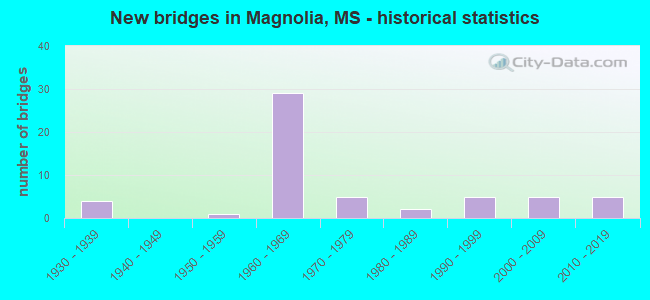
- New bridges - historical statistics
- 41930-1939
- 11950-1959
- 291960-1969
- 51970-1979
- 21980-1989
- 51990-1999
- 52000-2009
- 52010-2019


- Bridge Condition - Deck
- 12.1%Very good
- 57.6%Good
- 30.3%Satisfactory

- Bridge Condition - Superstructure
- 3.0%Excellent
- 18.2%Very good
- 42.4%Good
- 30.3%Satisfactory
- 6.1%Fair

- Bridge Condition - Substructure
- 45.5%Very good
- 30.3%Good
- 9.1%Satisfactory
- 9.1%Fair
- 3.0%Poor
- 3.0%Serious

- Bridge Condition - Channel
- 2.8%Excellent
- 36.1%Very good
- 19.4%Good
- 36.1%Satisfactory
- 2.8%Fair
- 2.8%Poor

- Bridge Condition - Culverts
- 10.0%Very good
- 80.0%Good
- 10.0%Fair
Find on map >> Show street view
Structure Number: 11000550570079, Location: 0.4 MI N SR 568 (Lat: 31.116839, Lng: -90.484250), Route carried "on" structure: Interstate 55, Year Built: 1960, Status: Open, Structure Length: 1.31m (4.30ft), Average Daily Traffic: 17,000 (year 2020), Truck Traffic: 29%, Average Future Daily Traffic: 19,000 (year 2040), Design Load: HS 20+Mod, Features Intersected: TANGIPAHOA RIVER TRIB
Minimum Vertical Clearance: 30+ m (98+ ft), Kilometerpoint: 13.098, Lanes on structure: 4, Base Highway Network: Yes (Inventory Route: 5, Subroute: 1), Owner: State Highway Agency, Approaching Roadway Width: 12.2m (40.0ft), Material/Design: Concrete, Design/Construction: Culvert, Number Of Spans In Main Unit: 2, Length of Maximum Span: 6.1m (20.0ft)
Condition: Channel: Satisfactory, Culverts: Good, Operating Rating: 63.0 metric tons, Method Used To Determine Operating Rating: Load Factor (LF), Inventory Rating: 37.8 metric tons, Method Used To Determine Inventory Rating: Load Factor (LF), Structural Evaluation: Better than present minimum criteria, Waterway Adequacy: Equal to present desirable criteria, Approach Roadway Alignment: Equal to present desirable criteria, Length Of Structure Improvement: 1.31m (4.30ft), Designated Inspection Frequency: Every 24 months, Inspection Date: November 2020, Bridge Improvement Cost: $169,000,000, Roadway Improvement Cost: $200,000,000, Total Project Cost: $369,000,000, Deck Structure Type: Concrete Cast-file-Place
Find on map >> Show street view
Structure Number: 11000550570084A, Location: 0.6 MI N SR 568 (Lat: 31.121311, Lng: -90.483822), Route carried "on" structure: Interstate 55, Year Built: 1960, Status: Open, Structure Length: 9.81m (32.19ft), Average Daily Traffic: 8,500 (year 2020), Truck Traffic: 29%, Average Future Daily Traffic: 9,500 (year 2040), Design Load: HS 20+Mod, Features Intersected: TANGIPAHOA RIVER
Minimum Vertical Clearance: 30+ m (98+ ft), Kilometerpoint: 25.378, Lanes on structure: 2, Base Highway Network: Yes (Inventory Route: 5, Subroute: 1), Owner: State Highway Agency, Approaching Roadway Width: 8.5m (27.9ft), Material/Design: Concrete, Design/Construction: Box Beam or Girders - Single/Spread, Number Of Spans In Main Unit: 3, Number Of Approach Spans: 4, Length of Maximum Span: 20.4m (66.9ft), Curb or Sidewalk Widths: Left: 0.3m (1.0ft), Right: 0.3m (1.0ft), Curb-To-Curb Width: 12.8m (42.0ft), Out-to-Out Width: 13.7m (44.9ft)
Condition: Deck: Good, Superstructure: Good, Substructure: Satisfactory, Channel: Satisfactory, Operating Rating: 42.4 metric tons, Method Used To Determine Operating Rating: Load Factor (LF), Inventory Rating: 25.4 metric tons, Method Used To Determine Inventory Rating: Load Factor (LF), Structural Evaluation: Equal to present minimum criteria, Deck Geometry: Somewhat better than minimum adequacy, Waterway Adequacy: Equal to present desirable criteria, Approach Roadway Alignment: Equal to present desirable criteria, Length Of Structure Improvement: 9.81m (32.19ft), Designated Inspection Frequency: Every 24 months, Underwater Inspection Frequency: Every 60 months, Inspection Date: November 2020, Underwater Inspection Date: June 2019, Bridge Improvement Cost: $256,000,000, Roadway Improvement Cost: $200,000,000, Total Project Cost: $456,000,000, Deck Structure Type: Concrete Cast-file-Place
Find on map >> Show street view
Structure Number: 11000550570084B, Location: 0.6 MI N SR 568 (Lat: 31.120283, Lng: -90.483706), Route carried "on" structure: Interstate 55, Year Built: 1960, Status: Open, Structure Length: 9.81m (32.19ft), Average Daily Traffic: 8,500 (year 2020), Truck Traffic: 29%, Average Future Daily Traffic: 9,500 (year 2040), Design Load: HS 20+Mod, Features Intersected: TANGIPAHOA RIVER
Minimum Vertical Clearance: 30+ m (98+ ft), Kilometerpoint: 13.485, Lanes on structure: 2, Base Highway Network: Yes (Inventory Route: 5, Subroute: 1), Owner: State Highway Agency, Approaching Roadway Width: 8.5m (27.9ft), Material/Design: Concrete, Design/Construction: Box Beam or Girders - Single/Spread, Number Of Spans In Main Unit: 3, Number Of Approach Spans: 4, Length of Maximum Span: 20.4m (66.9ft), Curb or Sidewalk Widths: Left: 0.3m (1.0ft), Right: 0.3m (1.0ft), Curb-To-Curb Width: 12.8m (42.0ft), Out-to-Out Width: 13.7m (44.9ft)
Condition: Deck: Good, Superstructure: Good, Substructure: Satisfactory, Channel: Satisfactory, Operating Rating: 42.4 metric tons, Method Used To Determine Operating Rating: Load Factor (LF), Inventory Rating: 25.4 metric tons, Method Used To Determine Inventory Rating: Load Factor (LF), Structural Evaluation: Equal to present minimum criteria, Deck Geometry: Somewhat better than minimum adequacy, Waterway Adequacy: Equal to present desirable criteria, Approach Roadway Alignment: Equal to present desirable criteria, Length Of Structure Improvement: 9.81m (32.19ft), Designated Inspection Frequency: Every 24 months, Underwater Inspection Frequency: Every 60 months, Inspection Date: November 2020, Underwater Inspection Date: June 2019, Bridge Improvement Cost: $256,000,000, Roadway Improvement Cost: $200,000,000, Total Project Cost: $456,000,000, Deck Structure Type: Concrete Cast-file-Place
Find on map >> Show street view
Structure Number: 11000550570086, Location: 0.8 MI N SR 568 (Lat: 31.122686, Lng: -90.483325), Route carried "on" structure: Interstate 55, Year Built: 1960, Status: Open, Structure Length: 1.31m (4.30ft), Average Daily Traffic: 17,000 (year 2020), Truck Traffic: 29%, Average Future Daily Traffic: 19,000 (year 2040), Design Load: HS 20+Mod, Features Intersected: TANGIPAHOA RIVER RELIEF
Minimum Vertical Clearance: 30+ m (98+ ft), Kilometerpoint: 13.753, Lanes on structure: 4, Base Highway Network: Yes (Inventory Route: 5, Subroute: 1), Owner: State Highway Agency, Approaching Roadway Width: 24.4m (80.1ft), Skew: 3 degrees, Material/Design: Concrete, Design/Construction: Culvert, Number Of Spans In Main Unit: 2, Length of Maximum Span: 6.1m (20.0ft)
Condition: Channel: Good, Culverts: Good, Operating Rating: 46.8 metric tons, Method Used To Determine Operating Rating: Load Factor (LF), Inventory Rating: 27.9 metric tons, Method Used To Determine Inventory Rating: Load Factor (LF), Structural Evaluation: Better than present minimum criteria, Waterway Adequacy: Equal to present desirable criteria, Approach Roadway Alignment: Equal to present desirable criteria, Designated Inspection Frequency: Every 24 months, Underwater Inspection Frequency: Every 60 months, Inspection Date: November 2020, Deck Structure Type: Concrete Cast-file-Place
Find on map >> Show street view
Structure Number: 11000550570118, Location: 1.5 MI N SR 48 (Lat: 31.168847, Lng: -90.480486), Route carried "on" structure: Interstate 55, Year Built: 1960, Status: Open, Structure Length: 1.58m (5.18ft), Average Daily Traffic: 18,000 (year 2020), Truck Traffic: 26%, Average Future Daily Traffic: 20,000 (year 2040), Design Load: HS 20+Mod, Features Intersected: MINNEHAHA CREEK
Minimum Vertical Clearance: 30+ m (98+ ft), Kilometerpoint: 18.918, Lanes on structure: 4, Base Highway Network: Yes (Inventory Route: 5, Subroute: 1), Owner: State Highway Agency, Approaching Roadway Width: 24.4m (80.1ft), Skew: 3 degrees, Material/Design: Concrete, Design/Construction: Culvert, Number Of Spans In Main Unit: 3, Length of Maximum Span: 4.9m (16.1ft)
Condition: Channel: Good, Culverts: Good, Operating Rating: 81.9 metric tons, Method Used To Determine Operating Rating: Load Factor (LF), Inventory Rating: 49.0 metric tons, Method Used To Determine Inventory Rating: Load Factor (LF), Structural Evaluation: Better than present minimum criteria, Waterway Adequacy: Equal to present desirable criteria, Approach Roadway Alignment: Equal to present desirable criteria, Designated Inspection Frequency: Every 24 months, Inspection Date: November 2020, Deck Structure Type: Concrete Cast-file-Place
Find on map >> Show street view
Structure Number: 21000510570073, Location: 0.8 MI S SR 568 (Lat: 31.101269, Lng: -90.483400), Route carried "on" structure: US 51, Year Built: 2011, Status: Open, Structure Length: 0.64m (2.10ft), Average Daily Traffic: 1,000 (year 2020), Truck Traffic: 11%, Average Future Daily Traffic: 1,000 (year 2040), Design Load: HS 20+Mod, Features Intersected: STREAM
Minimum Vertical Clearance: 30+ m (98+ ft), Kilometerpoint: 11.436, Lanes on structure: 2, Owner: State Highway Agency, Approaching Roadway Width: 12.0m (39.4ft), Skew: 1 degrees, Material/Design: Concrete, Design/Construction: Culvert, Number Of Spans In Main Unit: 2, Number Of Approach Spans: 1, Length of Maximum Span: 3.0m (9.8ft)
Condition: Channel: Very good, Culverts: Very good, Operating Rating: 69.8 metric tons, Method Used To Determine Operating Rating: Load Factor (LF), Inventory Rating: 41.8 metric tons, Method Used To Determine Inventory Rating: Load Factor (LF), Structural Evaluation: Equal to present desirable criteria, Waterway Adequacy: Equal to present desirable criteria, Approach Roadway Alignment: Equal to present desirable criteria, Designated Inspection Frequency: Every 24 months, Inspection Date: October 2020
Find on map >> Show street view
Structure Number: 21000510570082, Location: 0.1 MI N SR 568 (Lat: 31.112397, Lng: -90.479553), Route carried "on" structure: US 51, Year Built: 2011, Status: Open, Structure Length: 9.87m (32.38ft), Average Daily Traffic: 1,400 (year 2020), Truck Traffic: 11%, Average Future Daily Traffic: 1,400 (year 2040), Design Load: HS 20, Features Intersected: TANGIPAHOA RIVER
Minimum Vertical Clearance: 30+ m (98+ ft), Kilometerpoint: 12.728, Lanes on structure: 2, Owner: State Highway Agency, Approaching Roadway Width: 12.0m (39.4ft), Material/Design: Prestressed concrete, Design/Construction: Stringer/Multi-beam, Number Of Spans In Main Unit: 1, Number Of Approach Spans: 4, Length of Maximum Span: 31.9m (104.7ft), Curb-To-Curb Width: 12.0m (39.4ft), Out-to-Out Width: 12.9m (42.3ft)
Condition: Deck: Good, Superstructure: Very good, Substructure: Very good, Channel: Very good, Operating Rating: 72.6 metric tons, Method Used To Determine Operating Rating: Load Factor (LF), Inventory Rating: 32.1 metric tons, Method Used To Determine Inventory Rating: Load Factor (LF), Structural Evaluation: Better than present minimum criteria, Deck Geometry: Equal to present minimum criteria, Waterway Adequacy: Equal to present desirable criteria, Approach Roadway Alignment: Equal to present desirable criteria, Designated Inspection Frequency: Every 24 months, Inspection Date: October 2020, Deck Structure Type: Concrete Cast-file-Place
Find on map >> Show street view
Structure Number: 21000510570084, Location: 0.4 MI N SR 568 (Lat: 31.115864, Lng: -90.478089), Route carried "on" structure: US 51, Year Built: 2011, Status: Open, Structure Length: 6.67m (21.88ft), Average Daily Traffic: 1,400 (year 2020), Truck Traffic: 11%, Average Future Daily Traffic: 1,400 (year 2040), Design Load: HS 20, Features Intersected: TANGIPAHOA RELIEF
Minimum Vertical Clearance: 30+ m (98+ ft), Kilometerpoint: 13.137, Lanes on structure: 2, Owner: State Highway Agency, Approaching Roadway Width: 12.0m (39.4ft), Material/Design: Prestressed concrete, Design/Construction: Stringer/Multi-beam, Number Of Spans In Main Unit: 2, Number Of Approach Spans: 2, Length of Maximum Span: 18.0m (59.1ft), Curb-To-Curb Width: 12.0m (39.4ft), Out-to-Out Width: 12.9m (42.3ft)
Condition: Deck: Very good, Superstructure: Very good, Substructure: Very good, Channel: Very good, Operating Rating: 71.0 metric tons, Method Used To Determine Operating Rating: Load Factor (LF), Inventory Rating: 37.4 metric tons, Method Used To Determine Inventory Rating: Load Factor (LF), Structural Evaluation: Equal to present desirable criteria, Deck Geometry: Equal to present minimum criteria, Waterway Adequacy: Equal to present desirable criteria, Approach Roadway Alignment: Equal to present desirable criteria, Designated Inspection Frequency: Every 24 months, Underwater Inspection Frequency: Every 60 months, Inspection Date: October 2020, Underwater Inspection Date: June 2019, Deck Structure Type: Concrete Cast-file-Place
Find on map >> Show street view
Structure Number: 21000510570104, Location: 0.3 MI S SR 48 (Lat: 31.140694, Lng: -90.463422), Route carried "on" structure: US 51, Year Built: 2011, Status: Open, Structure Length: 6.78m (22.24ft), Average Daily Traffic: 2,400 (year 2020), Truck Traffic: 11%, Average Future Daily Traffic: 2,400 (year 2040), Design Load: HS 20, Features Intersected: MINNEHAHA CREEK
Minimum Vertical Clearance: 30+ m (98+ ft), Kilometerpoint: 16.230, Lanes on structure: 2, Owner: State Highway Agency, Approaching Roadway Width: 12.0m (39.4ft), Material/Design: Prestressed concrete continuous, Design/Construction: Stringer/Multi-beam, Number Of Spans In Main Unit: 4, Length of Maximum Span: 18.0m (59.1ft), Curb-To-Curb Width: 12.0m (39.4ft), Out-to-Out Width: 12.9m (42.3ft)
Condition: Deck: Good, Superstructure: Very good, Substructure: Very good, Channel: Very good, Operating Rating: 61.5 metric tons, Method Used To Determine Operating Rating: Load Factor (LF), Inventory Rating: 34.7 metric tons, Method Used To Determine Inventory Rating: Load Factor (LF), Structural Evaluation: Equal to present desirable criteria, Deck Geometry: Somewhat better than minimum adequacy, Waterway Adequacy: Equal to present desirable criteria, Approach Roadway Alignment: Equal to present desirable criteria, Designated Inspection Frequency: Every 24 months, Inspection Date: October 2020, Deck Structure Type: Concrete Cast-file-Place
Find on map >> Show street view
Structure Number: 21000510570117, Location: 1.2 M N SR 48 (Lat: 31.160431, Lng: -90.453486), Route carried "on" structure: US 51, Year Built: 1933, Status: Open, Structure Length: 0.67m (2.20ft), Average Daily Traffic: 5,900 (year 2020), Truck Traffic: 9%, Average Future Daily Traffic: 5,900 (year 2040), Design Load: H 15, Features Intersected: STREAM
Minimum Vertical Clearance: 30+ m (98+ ft), Kilometerpoint: 18.619, Lanes on structure: 2, Owner: State Highway Agency, Approaching Roadway Width: 7.3m (24.0ft), Material/Design: Concrete, Design/Construction: Slab, Number Of Spans In Main Unit: 1, Length of Maximum Span: 6.1m (20.0ft), Curb-To-Curb Width: 7.3m (24.0ft), Out-to-Out Width: 8.0m (26.2ft)
Condition: Deck: Satisfactory, Superstructure: Fair, Substructure: Good, Channel: Very good, Operating Rating: 57.9 metric tons, Method Used To Determine Operating Rating: Load Factor (LF), Inventory Rating: 34.6 metric tons, Method Used To Determine Inventory Rating: Load Factor (LF), Structural Evaluation: Somewhat better than minimum adequacy, Deck Geometry: High priority of replacement, Waterway Adequacy: Equal to present minimum criteria, Approach Roadway Alignment: Equal to present desirable criteria, Designated Inspection Frequency: Every 24 months, Inspection Date: October 2020, Deck Structure Type: Concrete Cast-file-Place, Wearing Surface/Protective System: Wearing Surface: Bituminous
Find on map >> Show street view
Structure Number: 21000510570121, Location: 1.6 MI N SR 48 (Lat: 31.165528, Lng: -90.452172), Route carried "on" structure: US 51, Year Built: 1933, Status: Open, Structure Length: 1.83m (6.00ft), Average Daily Traffic: 5,900 (year 2020), Truck Traffic: 9%, Average Future Daily Traffic: 5,900 (year 2040), Design Load: H 15, Features Intersected: UNNAMED STREAM
Minimum Vertical Clearance: 30+ m (98+ ft), Kilometerpoint: 19.196, Lanes on structure: 2, Owner: State Highway Agency, Approaching Roadway Width: 7.3m (24.0ft), Material/Design: Concrete, Design/Construction: Slab, Number Of Spans In Main Unit: 3, Length of Maximum Span: 6.1m (20.0ft), Curb or Sidewalk Widths: Left: 0.2m (0.7ft), Right: 0.2m (0.7ft), Curb-To-Curb Width: 7.3m (24.0ft), Out-to-Out Width: 7.6m (24.9ft)
Condition: Deck: Satisfactory, Superstructure: Fair, Substructure: Poor, Channel: Poor, Operating Rating: 50.2 metric tons, Method Used To Determine Operating Rating: Load Factor (LF), Inventory Rating: 30.1 metric tons, Method Used To Determine Inventory Rating: Load Factor (LF), Structural Evaluation: Meets minimum limits, Deck Geometry: High priority of replacement, Waterway Adequacy: Equal to present minimum criteria, Approach Roadway Alignment: Equal to present desirable criteria, Length Of Structure Improvement: 3.66m (12.01ft), Designated Inspection Frequency: Every 24 months, Inspection Date: October 2020, Bridge Improvement Cost: $275,000,000, Roadway Improvement Cost: $28,000,000, Total Project Cost: $828,000,000, Deck Structure Type: Concrete Cast-file-Place, Wearing Surface/Protective System: Wearing Surface: Bituminous
Find on map >> Show street view
Structure Number: 21000510570133, Location: 2.6 MI N SR 48 (Lat: 31.181808, Lng: -90.450553), Route carried "on" structure: US 51, Year Built: 1933, Status: Open, Structure Length: 0.98m (3.22ft), Average Daily Traffic: 6,600 (year 2020), Truck Traffic: 11%, Average Future Daily Traffic: 6,600 (year 2040), Design Load: H 15, Features Intersected: UNNAMED STREAM
Minimum Vertical Clearance: 30+ m (98+ ft), Kilometerpoint: 21.015, Lanes on structure: 2, Owner: State Highway Agency, Approaching Roadway Width: 7.3m (24.0ft), Material/Design: Concrete, Design/Construction: Tee Beam, Number Of Spans In Main Unit: 1, Length of Maximum Span: 9.8m (32.2ft), Curb or Sidewalk Widths: Left: 0.2m (0.7ft), Right: 0.2m (0.7ft), Curb-To-Curb Width: 7.3m (24.0ft), Out-to-Out Width: 7.6m (24.9ft)
Condition: Deck: Good, Superstructure: Good, Substructure: Good, Channel: Satisfactory, Operating Rating: 41.7 metric tons, Method Used To Determine Operating Rating: Load Factor (LF), Inventory Rating: 24.9 metric tons, Method Used To Determine Inventory Rating: Load Factor (LF), Structural Evaluation: Equal to present minimum criteria, Deck Geometry: High priority of replacement, Waterway Adequacy: Equal to present minimum criteria, Approach Roadway Alignment: Better than present minimum criteria, Length Of Structure Improvement: 1.96m (6.43ft), Designated Inspection Frequency: Every 24 months, Inspection Date: October 2020, Bridge Improvement Cost: $126,000,000, Roadway Improvement Cost: $13,000,000, Total Project Cost: $391,000,000, Deck Structure Type: Concrete Cast-file-Place, Wearing Surface/Protective System: Wearing Surface: Bituminous
Find on map >> Show street view
Structure Number: 21000510570134, Location: 2.7 MI N SR 48 (Lat: 31.183033, Lng: -90.450589), Route carried "on" structure: US 51, Year Built: 1933, Status: Open, Structure Length: 0.67m (2.20ft), Average Daily Traffic: 6,600 (year 2020), Truck Traffic: 11%, Average Future Daily Traffic: 6,600 (year 2040), Design Load: H 15, Features Intersected: STREAM
Minimum Vertical Clearance: 30+ m (98+ ft), Kilometerpoint: 21.150, Lanes on structure: 2, Owner: State Highway Agency, Approaching Roadway Width: 7.3m (24.0ft), Material/Design: Concrete, Design/Construction: Slab, Number Of Spans In Main Unit: 1, Length of Maximum Span: 6.1m (20.0ft), Curb-To-Curb Width: 7.3m (24.0ft), Out-to-Out Width: 8.0m (26.2ft)
Condition: Deck: Satisfactory, Superstructure: Satisfactory, Substructure: Good, Channel: Very good, Operating Rating: 57.9 metric tons, Method Used To Determine Operating Rating: Load Factor (LF), Inventory Rating: 34.6 metric tons, Method Used To Determine Inventory Rating: Load Factor (LF), Structural Evaluation: Equal to present minimum criteria, Deck Geometry: High priority of replacement, Waterway Adequacy: Equal to present minimum criteria, Approach Roadway Alignment: Equal to present desirable criteria, Designated Inspection Frequency: Every 24 months, Inspection Date: October 2020, Deck Structure Type: Concrete Cast-file-Place, Wearing Surface/Protective System: Wearing Surface: Bituminous
Find on map >> Show street view
Structure Number: 21000510570143, Location: 3.6 MI N SR 48 (Lat: 31.195542, Lng: -90.451231), Route carried "on" structure: US 51, Year Built: 1997, Status: Open, Structure Length: 1.46m (4.79ft), Average Daily Traffic: 4,900 (year 2020), Truck Traffic: 11%, Average Future Daily Traffic: 4,900 (year 2040), Design Load: HS 20, Features Intersected: LITTLE TANGIPAHOA RELIEF
Minimum Vertical Clearance: 30+ m (98+ ft), Kilometerpoint: 22.549, Lanes on structure: 2, Owner: State Highway Agency, Approaching Roadway Width: 7.3m (24.0ft), Skew: 2 degrees, Material/Design: Concrete, Design/Construction: Culvert, Number Of Spans In Main Unit: 2, Length of Maximum Span: 7.3m (24.0ft)
Condition: Channel: Very good, Culverts: Good, Operating Rating: 50.3 metric tons, Method Used To Determine Operating Rating: Load Factor (LF), Inventory Rating: 30.1 metric tons, Method Used To Determine Inventory Rating: Load Factor (LF), Structural Evaluation: Better than present minimum criteria, Waterway Adequacy: Equal to present desirable criteria, Approach Roadway Alignment: Equal to present desirable criteria, Designated Inspection Frequency: Every 24 months, Inspection Date: October 2020
Find on map >> Show street view
Structure Number: 21000510570144B, Location: 3.8 MI N SR 48 (Lat: 31.197922, Lng: -90.451867), Route carried "on" structure: US 51, Year Built: 1997, Status: Open, Structure Length: 6.10m (20.01ft), Average Daily Traffic: 4,900 (year 2020), Truck Traffic: 11%, Average Future Daily Traffic: 4,900 (year 2040), Design Load: HS 20, Features Intersected: LITTLE TANGIPAHOA RELIEF
Minimum Vertical Clearance: 30+ m (98+ ft), Kilometerpoint: 22.819, Lanes on structure: 2, Owner: State Highway Agency, Approaching Roadway Width: 7.3m (24.0ft), Skew: 2 degrees, Material/Design: Prestressed concrete continuous, Design/Construction: Stringer/Multi-beam, Number Of Spans In Main Unit: 5, Length of Maximum Span: 12.2m (40.0ft), Curb-To-Curb Width: 12.2m (40.0ft), Out-to-Out Width: 13.1m (43.0ft)
Condition: Deck: Good, Superstructure: Very good, Substructure: Very good, Channel: Very good, Operating Rating: 61.4 metric tons, Method Used To Determine Operating Rating: Load Factor (LF), Inventory Rating: 36.7 metric tons, Method Used To Determine Inventory Rating: Load Factor (LF), Structural Evaluation: Equal to present desirable criteria, Deck Geometry: Equal to present minimum criteria, Waterway Adequacy: Equal to present desirable criteria, Approach Roadway Alignment: Equal to present desirable criteria, Designated Inspection Frequency: Every 24 months, Inspection Date: October 2020, Deck Structure Type: Concrete Cast-file-Place
Find on map >> Show street view
Structure Number: 3100048057039, Location: SR 48 OVER NW RAMP I 55 (Lat: 31.147800, Lng: -90.481517), Route carried "on" structure: State highway 48, Year Built: 1960, Status: Open, Structure Length: 3.66m (12.01ft), Average Daily Traffic: 720 (year 2020), Truck Traffic: 11%, Average Future Daily Traffic: 720 (year 2040), Design Load: H 20, Features Intersected: NW RAMP I 55
Minimum Vertical Clearance: 30+ m (98+ ft), Kilometerpoint: 0.438, Lanes on structure: 2, Lanes under structure: 1, Owner: State Highway Agency, Approaching Roadway Width: 11.0m (36.1ft), Skew: 12 degrees, Material/Design: Concrete, Design/Construction: Slab, Number Of Spans In Main Unit: 3, Length of Maximum Span: 12.2m (40.0ft), Curb or Sidewalk Widths: Left: 0.5m (1.6ft), Right: 0.5m (1.6ft), Curb-To-Curb Width: 7.9m (25.9ft), Out-to-Out Width: 9.4m (30.8ft)
Condition: Deck: Good, Superstructure: Good, Substructure: Very good, Operating Rating: 77.5 metric tons, Method Used To Determine Operating Rating: Load Factor (LF), Inventory Rating: 46.4 metric tons, Method Used To Determine Inventory Rating: Load Factor (LF), Structural Evaluation: Better than present minimum criteria, Deck Geometry: High priority of replacement, Underclear: Somewhat better than minimum adequacy, Approach Roadway Alignment: Equal to present desirable criteria, Length Of Structure Improvement: 4.75m (15.58ft), Designated Inspection Frequency: Every 24 months, Inspection Date: November 2020, Bridge Improvement Cost: $392,000,000, Roadway Improvement Cost: $39,000,000, Total Project Cost: $999,999,000, Deck Structure Type: Concrete Cast-file-Place
Find on map >> Show street view
Structure Number: 31000480570391A, Location: SR 48 WB OVER I 55 (Lat: 31.146386, Lng: -90.479275), Route carried "on" structure: State highway 48, Year Built: 1960, Status: Open, Structure Length: 8.38m (27.49ft), Average Daily Traffic: 360 (year 2020), Truck Traffic: 11%, Average Future Daily Traffic: 360 (year 2040), Design Load: H 20, Features Intersected: I 55
Minimum Vertical Clearance: 30+ m (98+ ft), Kilometerpoint: 0.166, Lanes on structure: 2, Lanes under structure: 5, Owner: State Highway Agency, Approaching Roadway Width: 8.5m (27.9ft), Material/Design: Concrete continuous, Design/Construction: Box Beam or Girders - Single/Spread, Number Of Spans In Main Unit: 4, Length of Maximum Span: 24.4m (80.1ft), Curb or Sidewalk Widths: Left: 0.5m (1.6ft), Right: 0.5m (1.6ft), Curb-To-Curb Width: 8.5m (27.9ft), Out-to-Out Width: 10.1m (33.1ft)
Condition: Deck: Satisfactory, Superstructure: Satisfactory, Substructure: Very good, Operating Rating: 42.5 metric tons, Method Used To Determine Operating Rating: Load Factor (LF), Inventory Rating: 25.5 metric tons, Method Used To Determine Inventory Rating: Load Factor (LF), Structural Evaluation: Equal to present minimum criteria, Deck Geometry: High priority of corrective action, Underclear: Meets minimum limits, Approach Roadway Alignment: Equal to present desirable criteria, Length Of Structure Improvement: 9.50m (31.17ft), Designated Inspection Frequency: Every 24 months, Inspection Date: November 2020, Bridge Improvement Cost: $851,000,000, Roadway Improvement Cost: $85,000,000, Total Project Cost: $999,999,000, Deck Structure Type: Concrete Cast-file-Place
Find on map >> Show street view
Structure Number: 31000480570391B, Location: SR 48 EB OVER I 55 (Lat: 31.146078, Lng: -90.480189), Route carried "on" structure: State highway 48, Year Built: 1960, Status: Open, Structure Length: 8.29m (27.20ft), Average Daily Traffic: 360 (year 2020), Truck Traffic: 11%, Average Future Daily Traffic: 360 (year 2040), Design Load: H 20, Features Intersected: I 55
Minimum Vertical Clearance: 30+ m (98+ ft), Kilometerpoint: 8.465, Lanes on structure: 2, Lanes under structure: 5, Owner: State Highway Agency, Approaching Roadway Width: 8.5m (27.9ft), Skew: 10 degrees, Material/Design: Concrete continuous, Design/Construction: Box Beam or Girders - Single/Spread, Number Of Spans In Main Unit: 4, Length of Maximum Span: 24.4m (80.1ft), Curb or Sidewalk Widths: Left: 0.5m (1.6ft), Right: 0.5m (1.6ft), Curb-To-Curb Width: 8.5m (27.9ft), Out-to-Out Width: 10.1m (33.1ft)
Condition: Deck: Good, Superstructure: Good, Substructure: Very good, Operating Rating: 46.5 metric tons, Method Used To Determine Operating Rating: Load Factor (LF), Inventory Rating: 27.8 metric tons, Method Used To Determine Inventory Rating: Load Factor (LF), Structural Evaluation: Equal to present minimum criteria, Deck Geometry: High priority of corrective action, Underclear: Equal to present minimum criteria, Approach Roadway Alignment: Equal to present desirable criteria, Length Of Structure Improvement: 8.29m (27.20ft), Designated Inspection Frequency: Every 24 months, Inspection Date: November 2020, Bridge Improvement Cost: $440,000,000, Roadway Improvement Cost: $200,000,000, Total Project Cost: $769,000,000, Deck Structure Type: Concrete Cast-file-Place
Find on map >> Show street view
Structure Number: 31000480570403, Location: 0.2 MI W US 51 (Lat: 31.145614, Lng: -90.464683), Route carried "on" structure: State highway 48, Year Built: 1952, Status: Open, Structure Length: 1.19m (3.90ft), Average Daily Traffic: 8,800 (year 2020), Truck Traffic: 11%, Average Future Daily Traffic: 8,800 (year 2040), Design Load: H 15, Features Intersected: MINNEHAHA CREEK
Minimum Vertical Clearance: 30+ m (98+ ft), Kilometerpoint: 9.947, Lanes on structure: 2, Owner: State Highway Agency, Approaching Roadway Width: 7.9m (25.9ft), Material/Design: Concrete, Design/Construction: Culvert, Number Of Spans In Main Unit: 3, Length of Maximum Span: 3.7m (12.1ft)
Condition: Channel: Satisfactory, Culverts: Fair, Operating Rating: 32.5 metric tons, Method Used To Determine Operating Rating: Allowable Stress (AS), Inventory Rating: 24.3 metric tons, Method Used To Determine Inventory Rating: Allowable Stress (AS), Structural Evaluation: Somewhat better than minimum adequacy, Waterway Adequacy: Equal to present desirable criteria, Approach Roadway Alignment: Equal to present desirable criteria, Designated Inspection Frequency: Every 24 months, Inspection Date: October 2020
Find on map >> Show street view
Structure Number: 31000480570408, Location: 0.3 MI E US 51 (Lat: 31.142764, Lng: -90.456775), Route carried "on" structure: State highway 48, Year Built: 1971, Status: Open, Structure Length: 7.92m (25.98ft), Average Daily Traffic: 7,500 (year 2020), Truck Traffic: 11%, Average Future Daily Traffic: 7,500 (year 2040), Design Load: HS 20, Features Intersected: LITTLE TANGIPAHOA RIVER
Minimum Vertical Clearance: 30+ m (98+ ft), Kilometerpoint: 10.767, Lanes on structure: 2, Owner: State Highway Agency, Approaching Roadway Width: 12.2m (40.0ft), Material/Design: Prestressed concrete, Design/Construction: Stringer/Multi-beam, Number Of Spans In Main Unit: 5, Number Of Approach Spans: 2, Length of Maximum Span: 12.2m (40.0ft), Curb or Sidewalk Widths: Left: 0.0m, Right: 1.7m (5.6ft), Curb-To-Curb Width: 13.4m (44.0ft), Out-to-Out Width: 15.8m (51.8ft)
Condition: Deck: Very good, Superstructure: Good, Substructure: Very good, Channel: Satisfactory, Operating Rating: 49.7 metric tons, Method Used To Determine Operating Rating: Load Factor (LF), Inventory Rating: 29.8 metric tons, Method Used To Determine Inventory Rating: Load Factor (LF), Structural Evaluation: Better than present minimum criteria, Deck Geometry: Equal to present minimum criteria, Waterway Adequacy: Equal to present desirable criteria, Approach Roadway Alignment: Equal to present desirable criteria, Designated Inspection Frequency: Every 24 months, Inspection Date: October 2020, Deck Structure Type: Concrete Cast-file-Place
Find on map >> Show street view
Structure Number: 31000480570412, Location: 0.7 MI E US 51 (Lat: 31.138869, Lng: -90.454014), Route carried "on" structure: State highway 48, Year Built: 1972, Status: Open, Structure Length: 0.67m (2.20ft), Average Daily Traffic: 4,300 (year 2020), Truck Traffic: 11%, Average Future Daily Traffic: 4,300 (year 2040), Design Load: H 20, Features Intersected: UNNAMED STREAM
Minimum Vertical Clearance: 30+ m (98+ ft), Kilometerpoint: 11.317, Lanes on structure: 2, Owner: State Highway Agency, Approaching Roadway Width: 7.9m (25.9ft), Material/Design: Concrete, Design/Construction: Culvert, Number Of Spans In Main Unit: 2, Length of Maximum Span: 3.0m (9.8ft)
Condition: Channel: Satisfactory, Culverts: Good, Operating Rating: 99.8 metric tons, Method Used To Determine Operating Rating: Load Factor (LF), Inventory Rating: 66.1 metric tons, Method Used To Determine Inventory Rating: Load Factor (LF), Structural Evaluation: Better than present minimum criteria, Waterway Adequacy: Equal to present desirable criteria, Approach Roadway Alignment: Equal to present desirable criteria, Designated Inspection Frequency: Every 24 months, Inspection Date: October 2020
Find on map >> Show street view
Structure Number: 31005680570162, Location: SR 568 OVER I 55 (Lat: 31.111106, Lng: -90.485689), Route carried "on" structure: State highway 568, Year Built: 1960, Status: Open, Structure Length: 7.32m (24.02ft), Average Daily Traffic: 860 (year 2020), Truck Traffic: 11%, Average Future Daily Traffic: 860 (year 2040), Design Load: H 20, Features Intersected: I 55
Minimum Vertical Clearance: 30+ m (98+ ft), Kilometerpoint: 6.616, Lanes on structure: 2, Lanes under structure: 4, Owner: State Highway Agency, Approaching Roadway Width: 8.5m (27.9ft), Skew: 1 degrees, Material/Design: Concrete continuous, Design/Construction: Box Beam or Girders - Single/Spread, Number Of Spans In Main Unit: 2, Number Of Approach Spans: 2, Length of Maximum Span: 21.3m (69.9ft), Curb or Sidewalk Widths: Left: 0.3m (1.0ft), Right: 0.3m (1.0ft), Curb-To-Curb Width: 8.5m (27.9ft), Out-to-Out Width: 9.4m (30.8ft)
Condition: Deck: Good, Superstructure: Good, Substructure: Good, Operating Rating: 36.6 metric tons, Method Used To Determine Operating Rating: Load Factor (LF), Inventory Rating: 22.0 metric tons, Method Used To Determine Inventory Rating: Load Factor (LF), Structural Evaluation: Somewhat better than minimum adequacy, Deck Geometry: Somewhat better than minimum adequacy, Underclear: Equal to present minimum criteria, Approach Roadway Alignment: Equal to present desirable criteria, Length Of Structure Improvement: 7.32m (24.02ft), Designated Inspection Frequency: Every 24 months, Inspection Date: November 2020, Bridge Improvement Cost: $388,000,000, Roadway Improvement Cost: $200,000,000, Total Project Cost: $706,000,000, Deck Structure Type: Concrete Cast-file-Place
Find on map >> Show street view
Structure Number: 31005700030023, Location: 4.3 MI W SR 569 (Lat: 31.342356, Lng: -90.691039), Route carried "on" structure: State highway 570, Year Built: 1989, Status: Open, Structure Length: 2.83m (9.28ft), Average Daily Traffic: 630 (year 2020), Truck Traffic: 11%, Average Future Daily Traffic: 630 (year 2040), Design Load: HS 20, Features Intersected: SHACKALOA CREEK
Minimum Vertical Clearance: 30+ m (98+ ft), Kilometerpoint: 2.527, Lanes on structure: 2, Owner: State Highway Agency, Approaching Roadway Width: 8.5m (27.9ft), Material/Design: Concrete, Design/Construction: Channel Beam, Number Of Spans In Main Unit: 3, Length of Maximum Span: 9.4m (30.8ft), Curb-To-Curb Width: 8.5m (27.9ft), Out-to-Out Width: 9.4m (30.8ft)
Condition: Deck: Good, Superstructure: Good, Substructure: Very good, Channel: Satisfactory, Operating Rating: 81.0 metric tons, Method Used To Determine Operating Rating: Load Factor (LF), Inventory Rating: 51.2 metric tons, Method Used To Determine Inventory Rating: Load Factor (LF), Structural Evaluation: Better than present minimum criteria, Deck Geometry: Somewhat better than minimum adequacy, Waterway Adequacy: Equal to present desirable criteria, Approach Roadway Alignment: Equal to present desirable criteria, Designated Inspection Frequency: Every 24 months, Inspection Date: Febuary 2022, Deck Structure Type: Concrete Precast Panels
Find on map >> Show street view
Structure Number: 31005750570024, Location: 2.3 MI S SR 48 (Lat: 31.072522, Lng: -90.314775), Route carried "on" structure: State highway 575, Year Built: 1998, Status: Open, Structure Length: 3.73m (12.24ft), Average Daily Traffic: 500 (year 2020), Truck Traffic: 19%, Average Future Daily Traffic: 500 (year 2040), Design Load: HS 20, Features Intersected: SILVER SPRING CREEK
Minimum Vertical Clearance: 30+ m (98+ ft), Kilometerpoint: 3.906, Lanes on structure: 2, Owner: State Highway Agency, Approaching Roadway Width: 11.0m (36.1ft), Skew: 4 degrees, Material/Design: Prestressed concrete, Design/Construction: Stringer/Multi-beam, Number Of Spans In Main Unit: 3, Length of Maximum Span: 12.2m (40.0ft), Curb-To-Curb Width: 11.0m (36.1ft), Out-to-Out Width: 11.8m (38.7ft)
Condition: Deck: Very good, Superstructure: Very good, Substructure: Very good, Channel: Very good, Operating Rating: 52.8 metric tons, Method Used To Determine Operating Rating: Load Factor (LF), Inventory Rating: 31.7 metric tons, Method Used To Determine Inventory Rating: Load Factor (LF), Structural Evaluation: Better than present minimum criteria, Deck Geometry: Better than present minimum criteria, Waterway Adequacy: Equal to present desirable criteria, Approach Roadway Alignment: Equal to present desirable criteria, Designated Inspection Frequency: Every 24 months, Inspection Date: October 2020, Deck Structure Type: Concrete Cast-file-Place
Find on map >> Show street view
Structure Number: 41000550570093, Location: 1.5 MI N SR 568 (Lat: 31.132997, Lng: -90.482183), Route carried "on" structure: County highway , Year Built: 1960, Status: Open, Structure Length: 6.98m (22.90ft), Average Daily Traffic: 1,700 (year 2020), Truck Traffic: 11%, Average Future Daily Traffic: 1,700 (year 2040), Design Load: H 20, Features Intersected: I 55, Facility Carried by Structure: HAMP LEE ROAD
Minimum Vertical Clearance: 30+ m (98+ ft), Kilometerpoint: 6.696, Lanes on structure: 2, Lanes under structure: 4, Owner: State Highway Agency, Approaching Roadway Width: 8.5m (27.9ft), Skew: 3 degrees, Material/Design: Concrete continuous, Design/Construction: Box Beam or Girders - Single/Spread, Number Of Spans In Main Unit: 4, Length of Maximum Span: 20.4m (66.9ft), Curb or Sidewalk Widths: Left: 0.3m (1.0ft), Right: 0.3m (1.0ft), Curb-To-Curb Width: 8.5m (27.9ft), Out-to-Out Width: 9.4m (30.8ft)
Condition: Deck: Good, Superstructure: Good, Substructure: Good, Operating Rating: 56.1 metric tons, Method Used To Determine Operating Rating: Load Factor (LF), Inventory Rating: 33.6 metric tons, Method Used To Determine Inventory Rating: Load Factor (LF), Structural Evaluation: Better than present minimum criteria, Deck Geometry: Somewhat better than minimum adequacy, Underclear: Equal to present minimum criteria, Approach Roadway Alignment: Equal to present desirable criteria, Designated Inspection Frequency: Every 24 months, Inspection Date: November 2020, Deck Structure Type: Concrete Cast-file-Place
Find on map >> Show street view
Structure Number: 41000550570132, Location: 2.9 MI N SR 48 (Lat: 31.189936, Lng: -90.484669), Route carried "on" structure: County highway , Year Built: 1961, Status: Open, Structure Length: 6.98m (22.90ft), Average Daily Traffic: 1,400 (year 2020), Truck Traffic: 11%, Average Future Daily Traffic: 1,400 (year 2040), Design Load: H 20, Features Intersected: I 55, Facility Carried by Structure: FERNWOOD ROAD
Minimum Vertical Clearance: 30+ m (98+ ft), Kilometerpoint: 1.080, Lanes on structure: 2, Lanes under structure: 4, Owner: State Highway Agency, Approaching Roadway Width: 8.5m (27.9ft), Material/Design: Concrete continuous, Design/Construction: Box Beam or Girders - Single/Spread, Number Of Spans In Main Unit: 4, Length of Maximum Span: 20.4m (66.9ft), Curb or Sidewalk Widths: Left: 0.3m (1.0ft), Right: 0.3m (1.0ft), Curb-To-Curb Width: 8.5m (27.9ft), Out-to-Out Width: 9.4m (30.8ft)
Condition: Deck: Satisfactory, Superstructure: Satisfactory, Substructure: Good, Operating Rating: 39.3 metric tons, Method Used To Determine Operating Rating: Load Factor (LF), Inventory Rating: 23.5 metric tons, Method Used To Determine Inventory Rating: Load Factor (LF), Structural Evaluation: Equal to present minimum criteria, Deck Geometry: Somewhat better than minimum adequacy, Underclear: Somewhat better than minimum adequacy, Approach Roadway Alignment: Equal to present desirable criteria, Designated Inspection Frequency: Every 24 months, Inspection Date: November 2020, Deck Structure Type: Concrete Cast-file-Place
Find on map >> Show street view
Structure Number: 41000550570143, Location: 4.0 MI N SR 48 (Lat: 31.205036, Lng: -90.484342), Route carried "on" structure: County highway , Year Built: 1960, Status: Open, Structure Length: 7.32m (24.02ft), Average Daily Traffic: 170 (year 2020), Truck Traffic: 8%, Average Future Daily Traffic: 170 (year 2040), Design Load: H 20, Features Intersected: I 55, Facility Carried by Structure: WARDLOW ROAD
Minimum Vertical Clearance: 30+ m (98+ ft), Kilometerpoint: 1.547, Lanes on structure: 2, Lanes under structure: 4, Owner: State Highway Agency, Approaching Roadway Width: 8.2m (26.9ft), Skew: 3 degrees, Material/Design: Concrete continuous, Design/Construction: Box Beam or Girders - Single/Spread, Number Of Spans In Main Unit: 4, Length of Maximum Span: 21.3m (69.9ft), Curb or Sidewalk Widths: Left: 0.8m (2.6ft), Right: 0.8m (2.6ft), Curb-To-Curb Width: 8.2m (26.9ft), Out-to-Out Width: 9.4m (30.8ft)
Condition: Deck: Good, Superstructure: Good, Substructure: Very good, Operating Rating: 36.6 metric tons, Method Used To Determine Operating Rating: Load Factor (LF), Inventory Rating: 21.7 metric tons, Method Used To Determine Inventory Rating: Load Factor (LF), Structural Evaluation: Equal to present minimum criteria, Deck Geometry: Somewhat better than minimum adequacy, Underclear: Equal to present minimum criteria, Approach Roadway Alignment: Equal to present desirable criteria, Designated Inspection Frequency: Every 24 months, Inspection Date: October 2020, Deck Structure Type: Concrete Cast-file-Place
Find on map >> Show street view
Structure Number: SA5700000000058, Location: SEC 14 T 2N R 7E (Lat: 31.142889, Lng: -90.464167), Route carried "on" structure: County highway 1072, Year Built: 2003, Status: Open, Structure Length: 2.95m (9.68ft), Average Daily Traffic: 750 (year 2021), Truck Traffic: 8%, Average Future Daily Traffic: 1,125 (year 2043), Design Load: H 15, Features Intersected: MINNEHAHA CREEK, Facility Carried by Structure: PREWETT STREET
Minimum Vertical Clearance: 30+ m (98+ ft), Kilometerpoint: 1.725, Lanes on structure: 2, Owner: County Highway Agency, Approaching Roadway Width: 7.0m (23.0ft), Material/Design: Concrete, Design/Construction: Channel Beam, Number Of Spans In Main Unit: 5, Length of Maximum Span: 5.8m (19.0ft), Curb or Sidewalk Widths: Left: 0.2m (0.7ft), Right: 0.2m (0.7ft), Curb-To-Curb Width: 7.1m (23.3ft), Out-to-Out Width: 7.5m (24.6ft)
Condition: Deck: Good, Superstructure: Satisfactory, Substructure: Good, Channel: Satisfactory, Operating Rating: 59.4 metric tons, Method Used To Determine Operating Rating: Load Factor (LF), Inventory Rating: 35.5 metric tons, Method Used To Determine Inventory Rating: Load Factor (LF), Structural Evaluation: Equal to present minimum criteria, Deck Geometry: Meets minimum limits, Waterway Adequacy: Equal to present desirable criteria, Approach Roadway Alignment: Better than present minimum criteria, Length Of Structure Improvement: 4.42m (14.50ft), Designated Inspection Frequency: Every 24 months, Inspection Date: March 2021, Bridge Improvement Cost: $357,000, Roadway Improvement Cost: $286,000, Total Project Cost: $643,000 ( Estimate for 2021), Deck Structure Type: Concrete Precast Panels
Find on map >> Show street view
Structure Number: SA5700000000059, Location: SEC 16 T 2N R 7E B (Lat: 31.145694, Lng: -90.500028), Route carried "on" structure: County highway 53, Year Built: 2004, Status: Open, Structure Length: 0.73m (2.40ft), Average Daily Traffic: 430 (year 2021), Truck Traffic: 8%, Average Future Daily Traffic: 645 (year 2043), Design Load: HS 20, Features Intersected: SMALL CREEK, Facility Carried by Structure: MUDDY SPRINGS ROAD
Minimum Vertical Clearance: 30+ m (98+ ft), Kilometerpoint: 2.414, Lanes on structure: 2, Owner: County Highway Agency, Approaching Roadway Width: 8.5m (27.9ft), Skew: 3 degrees, Material/Design: Concrete, Design/Construction: Culvert, Number Of Spans In Main Unit: 2, Length of Maximum Span: 3.5m (11.5ft)
Condition: Channel: Very good, Culverts: Good, Operating Rating: 66.4 metric tons, Method Used To Determine Operating Rating: Load Factor (LF) rating reported by rating factor (RF) method using MS18 loading, Inventory Rating: 39.9 metric tons, Method Used To Determine Inventory Rating: Load Factor (LF) rating reported by rating factor (RF) method using MS18 loading, Structural Evaluation: Better than present minimum criteria, Waterway Adequacy: Equal to present desirable criteria, Approach Roadway Alignment: Equal to present desirable criteria, Length Of Structure Improvement: 1.10m (3.61ft), Designated Inspection Frequency: Every 24 months, Inspection Date: March 2021, Bridge Improvement Cost: $49,000, Roadway Improvement Cost: $40,000, Total Project Cost: $89,000 ( Estimate for 2018)
Find on map >> Show street view
Structure Number: SA570000000006, Location: SEC 17 T 2N R 7E B (Lat: 31.145444, Lng: -90.514917), Route carried "on" structure: County highway 53, Year Built: 1965, Status: Posted for load, Structure Length: 3.54m (11.61ft), Average Daily Traffic: 430 (year 2020), Truck Traffic: 8%, Average Future Daily Traffic: 645 (year 2042), Design Load: H 15, Features Intersected: RELIEF TANGIPAHOA RIVER, Facility Carried by Structure: MUDDY SPRINGS ROAD
Minimum Vertical Clearance: 30+ m (98+ ft), Kilometerpoint: 3.057, Lanes on structure: 2, Owner: County Highway Agency, Approaching Roadway Width: 6.1m (20.0ft), Material/Design: Steel, Design/Construction: Stringer/Multi-beam, Number Of Spans In Main Unit: 1, Number Of Approach Spans: 4, Length of Maximum Span: 12.2m (40.0ft), Curb or Sidewalk Widths: Left: 0.4m (1.3ft), Right: 0.4m (1.3ft), Curb-To-Curb Width: 6.7m (22.0ft), Out-to-Out Width: 7.5m (24.6ft)
Condition: Deck: Satisfactory, Superstructure: Satisfactory, Substructure: Fair, Channel: Fair, Operating Rating: 28.1 metric tons, Method Used To Determine Operating Rating: Load Factor (LF), Inventory Rating: 16.8 metric tons, Method Used To Determine Inventory Rating: Load Factor (LF), Structural Evaluation: Somewhat better than minimum adequacy, Deck Geometry: Meets minimum limits, Waterway Adequacy: Equal to present desirable criteria, Approach Roadway Alignment: Equal to present minimum criteria, Bridge Posting: Required (Relationship of Operating Rating to Maximum Legal Load: 20.0 - 29.9% below), Length Of Structure Improvement: 5.31m (17.42ft), Designated Inspection Frequency: Every 24 months, Inspection Date: December 2020, Bridge Improvement Cost: $430,000, Roadway Improvement Cost: $344,000, Total Project Cost: $774,000 ( Estimate for 2020), Deck Structure Type: Concrete Cast-file-Place
Find on map >> Show street view
Structure Number: SA5700000000061, Location: SEC 17 T 2N R 7E B (Lat: 31.143917, Lng: -90.518111), Route carried "on" structure: County highway 53, Year Built: 1965, Status: Posted for load, Structure Length: 8.53m (27.99ft), Average Daily Traffic: 430 (year 2020), Truck Traffic: 8%, Average Future Daily Traffic: 645 (year 2042), Design Load: H 15, Features Intersected: TANGIPAHOA RIVER, Facility Carried by Structure: MUDDY SPRINGS ROAD
Minimum Vertical Clearance: 30+ m (98+ ft), Kilometerpoint: 3.218, Lanes on structure: 2, Owner: County Highway Agency, Approaching Roadway Width: 6.1m (20.0ft), Material/Design: Steel, Design/Construction: Stringer/Multi-beam, Number Of Spans In Main Unit: 7, Length of Maximum Span: 12.2m (40.0ft), Curb or Sidewalk Widths: Left: 0.3m (1.0ft), Right: 0.3m (1.0ft), Curb-To-Curb Width: 6.7m (22.0ft), Out-to-Out Width: 7.4m (24.3ft)
Condition: Deck: Satisfactory, Superstructure: Satisfactory, Substructure: Satisfactory, Channel: Satisfactory, Operating Rating: 28.2 metric tons, Method Used To Determine Operating Rating: Load Factor (LF), Inventory Rating: 17.0 metric tons, Method Used To Determine Inventory Rating: Load Factor (LF), Structural Evaluation: Somewhat better than minimum adequacy, Deck Geometry: Meets minimum limits, Waterway Adequacy: Equal to present desirable criteria, Approach Roadway Alignment: Equal to present desirable criteria, Bridge Posting: Required (Relationship of Operating Rating to Maximum Legal Load: 20.0 - 29.9% below), Length Of Structure Improvement: 12.79m (41.96ft), Designated Inspection Frequency: Every 24 months, Inspection Date: December 2020, Bridge Improvement Cost: $1,019,000, Roadway Improvement Cost: $816,000, Total Project Cost: $1,835,000 ( Estimate for 2020), Deck Structure Type: Concrete Cast-file-Place
Find on map >> Show street view
Structure Number: SA5700000000062, Location: SEC 21 T 2N R 7E (Lat: 31.127111, Lng: -90.512111), Route carried "on" structure: County highway 76, Year Built: 1998, Status: Open, Structure Length: 2.16m (7.09ft), Average Daily Traffic: 115 (year 2021), Truck Traffic: 8%, Average Future Daily Traffic: 120 (year 2043), Design Load: HS 20, Features Intersected: SMALL DRAIN, Facility Carried by Structure: LAZY HEFIER ROAD
Minimum Vertical Clearance: 30+ m (98+ ft), Kilometerpoint: 0.321, Lanes on structure: 2, Owner: County Highway Agency, Approaching Roadway Width: 6.7m (22.0ft), Material/Design: Concrete, Design/Construction: Channel Beam, Number Of Spans In Main Unit: 3, Length of Maximum Span: 9.4m (30.8ft), Curb or Sidewalk Widths: Left: 0.2m (0.7ft), Right: 0.2m (0.7ft), Curb-To-Curb Width: 7.4m (24.3ft), Out-to-Out Width: 7.8m (25.6ft)
Condition: Deck: Good, Superstructure: Good, Substructure: Very good, Channel: Very good, Operating Rating: 70.5 metric tons, Method Used To Determine Operating Rating: Load Factor (LF), Inventory Rating: 42.1 metric tons, Method Used To Determine Inventory Rating: Load Factor (LF), Structural Evaluation: Better than present minimum criteria, Deck Geometry: Somewhat better than minimum adequacy, Waterway Adequacy: Equal to present desirable criteria, Approach Roadway Alignment: Better than present minimum criteria, Length Of Structure Improvement: 2.95m (9.68ft), Designated Inspection Frequency: Every 24 months, Inspection Date: March 2021, Bridge Improvement Cost: $262,000, Roadway Improvement Cost: $210,000, Total Project Cost: $472,000 ( Estimate for 2021), Deck Structure Type: Concrete Precast Panels
Find on map >> Show street view
Structure Number: SA5700000000063, Location: SEC 22 T 2N R 7E B (Lat: 31.127528, Lng: -90.493222), Route carried "on" structure: County highway 164, Year Built: 1977, Status: Posted for load, Structure Length: 3.47m (11.38ft), Average Daily Traffic: 620 (year 2021), Truck Traffic: 7%, Average Future Daily Traffic: 985 (year 2043), Design Load: HS 20, Features Intersected: RELIEF TANGIPAHOA RIVER, Facility Carried by Structure: HAMP LEA ROAD
Minimum Vertical Clearance: 30+ m (98+ ft), Kilometerpoint: 5.471, Lanes on structure: 2, Owner: County Highway Agency, Approaching Roadway Width: 7.3m (24.0ft), Material/Design: Concrete, Design/Construction: Slab, Number Of Spans In Main Unit: 6, Length of Maximum Span: 5.8m (19.0ft), Curb-To-Curb Width: 8.5m (27.9ft), Out-to-Out Width: 9.4m (30.8ft)
Condition: Deck: Satisfactory, Superstructure: Satisfactory, Substructure: Fair, Channel: Good, Operating Rating: 26.6 metric tons, Method Used To Determine Operating Rating: Load Factor (LF), Inventory Rating: 15.9 metric tons, Method Used To Determine Inventory Rating: Load Factor (LF), Structural Evaluation: Meets minimum limits, Deck Geometry: Somewhat better than minimum adequacy, Waterway Adequacy: Superior to present desirable criteria, Approach Roadway Alignment: Equal to present minimum criteria, Bridge Posting: Required (Relationship of Operating Rating to Maximum Legal Load: 30.0 - 39.9% below), Length Of Structure Improvement: 4.37m (14.34ft), Designated Inspection Frequency: Every 24 months, Inspection Date: March 2021, Bridge Improvement Cost: $445,000, Roadway Improvement Cost: $356,000, Total Project Cost: $801,000 ( Estimate for 2021), Deck Structure Type: Concrete Cast-file-Place
Find on map >> Show street view
Structure Number: SA5700000000064, Location: SEC 22 T 2N R 7E B (Lat: 31.128417, Lng: -90.492611), Route carried "on" structure: County highway 164, Year Built: 1964, Status: Open, Structure Length: 6.10m (20.01ft), Average Daily Traffic: 650 (year 2021), Truck Traffic: 7%, Average Future Daily Traffic: 990 (year 2043), Design Load: H 15, Features Intersected: TANGIPAHOA RIVER, Facility Carried by Structure: HAMP LEA ROAD
Minimum Vertical Clearance: 30+ m (98+ ft), Kilometerpoint: 5.632, Lanes on structure: 2, Owner: County Highway Agency, Approaching Roadway Width: 6.1m (20.0ft), Material/Design: Concrete, Design/Construction: Stringer/Multi-beam, Number Of Spans In Main Unit: 5, Length of Maximum Span: 12.2m (40.0ft), Curb or Sidewalk Widths: Left: 0.4m (1.3ft), Right: 0.4m (1.3ft), Curb-To-Curb Width: 6.7m (22.0ft), Out-to-Out Width: 7.5m (24.6ft)
Condition: Deck: Good, Superstructure: Good, Substructure: Good, Channel: Very good, Operating Rating: 49.7 metric tons, Method Used To Determine Operating Rating: Load Factor (LF), Inventory Rating: 29.8 metric tons, Method Used To Determine Inventory Rating: Load Factor (LF), Structural Evaluation: Better than present minimum criteria, Deck Geometry: Meets minimum limits, Waterway Adequacy: Superior to present desirable criteria, Approach Roadway Alignment: Equal to present desirable criteria, Length Of Structure Improvement: 7.14m (23.43ft), Designated Inspection Frequency: Every 24 months, Inspection Date: April 2021, Bridge Improvement Cost: $633,000, Roadway Improvement Cost: $507,000, Total Project Cost: $1,140,000 ( Estimate for 2021), Deck Structure Type: Concrete Cast-file-Place
Find on map >> Show street view
Structure Number: SA5700000000065, Location: SEC 22 T 2N R 7E B (Lat: 31.129583, Lng: -90.491861), Route carried "on" structure: County highway 164, Year Built: 1977, Status: Posted for load, Structure Length: 2.32m (7.61ft), Average Daily Traffic: 630 (year 2021), Truck Traffic: 7%, Average Future Daily Traffic: 1,275 (year 2043), Design Load: HS 20, Features Intersected: RELIEF TANGIPAHOA RIVER, Facility Carried by Structure: HAMP LEA ROAD
Minimum Vertical Clearance: 30+ m (98+ ft), Kilometerpoint: 5.793, Lanes on structure: 2, Owner: County Highway Agency, Approaching Roadway Width: 6.1m (20.0ft), Material/Design: Concrete, Design/Construction: Slab, Number Of Spans In Main Unit: 4, Length of Maximum Span: 5.8m (19.0ft), Curb-To-Curb Width: 8.5m (27.9ft), Out-to-Out Width: 9.4m (30.8ft)
Condition: Deck: Satisfactory, Superstructure: Satisfactory, Substructure: Fair, Channel: Satisfactory, Operating Rating: 26.7 metric tons, Method Used To Determine Operating Rating: Load Factor (LF), Inventory Rating: 16.0 metric tons, Method Used To Determine Inventory Rating: Load Factor (LF), Structural Evaluation: Meets minimum limits, Deck Geometry: Somewhat better than minimum adequacy, Waterway Adequacy: Better than present minimum criteria, Approach Roadway Alignment: Better than present minimum criteria, Bridge Posting: Required (Relationship of Operating Rating to Maximum Legal Load: 30.0 - 39.9% below), Length Of Structure Improvement: 3.15m (10.33ft), Designated Inspection Frequency: Every 24 months, Inspection Date: April 2021, Bridge Improvement Cost: $319,000, Roadway Improvement Cost: $256,000, Total Project Cost: $575,000 ( Estimate for 2021), Deck Structure Type: Concrete Cast-file-Place
Find on map >> Show street view
Structure Number: SA5700000000067, Location: SEC 36 T 2N R 7E B (Lat: 31.101694, Lng: -90.446500), Route carried "on" structure: County highway 1185, Year Built: 1994, Status: Open, Structure Length: 1.13m (3.71ft), Average Daily Traffic: 350 (year 2021), Truck Traffic: 8%, Average Future Daily Traffic: 520 (year 2043), Design Load: HS 20, Features Intersected: TAN CREEK, Facility Carried by Structure: CENTERVILLE ROAD
Minimum Vertical Clearance: 30+ m (98+ ft), Kilometerpoint: 8.851, Lanes on structure: 2, Owner: County Highway Agency, Approaching Roadway Width: 10.1m (33.1ft), Material/Design: Concrete, Design/Construction: Culvert, Number Of Spans In Main Unit: 2, Length of Maximum Span: 5.5m (18.0ft)
Condition: Channel: Good, Culverts: Good, Operating Rating: 54.9 metric tons, Method Used To Determine Operating Rating: Load Factor (LF), Inventory Rating: 32.7 metric tons, Method Used To Determine Inventory Rating: Load Factor (LF), Structural Evaluation: Better than present minimum criteria, Waterway Adequacy: Better than present minimum criteria, Approach Roadway Alignment: Equal to present desirable criteria, Length Of Structure Improvement: 1.82m (5.97ft), Designated Inspection Frequency: Every 24 months, Inspection Date: December 2021, Bridge Improvement Cost: $161,000, Roadway Improvement Cost: $129,000, Total Project Cost: $290,000 ( Estimate for 2021)
Find on map >> Show street view
Structure Number: SA5700000000068, Location: SEC 36 T 2N R 7E (Lat: 31.097889, Lng: -90.463278), Route carried "on" structure: County highway 146, Year Built: 2001, Status: Open, Structure Length: 2.88m (9.45ft), Average Daily Traffic: 50 (year 2021), Truck Traffic: 8%, Average Future Daily Traffic: 75 (year 2043), Design Load: HS 20, Features Intersected: SMALL CREEK, Facility Carried by Structure: LINDBERGH ROAD
Minimum Vertical Clearance: 30+ m (98+ ft), Kilometerpoint: 3.057, Lanes on structure: 2, Owner: County Highway Agency, Approaching Roadway Width: 6.7m (22.0ft), Material/Design: Concrete, Design/Construction: Channel Beam, Number Of Spans In Main Unit: 3, Length of Maximum Span: 9.4m (30.8ft), Curb or Sidewalk Widths: Left: 0.2m (0.7ft), Right: 0.2m (0.7ft), Curb-To-Curb Width: 7.4m (24.3ft), Out-to-Out Width: 7.8m (25.6ft)
Condition: Deck: Good, Superstructure: Very good, Substructure: Very good, Channel: Very good, Operating Rating: 73.8 metric tons, Method Used To Determine Operating Rating: Load Factor (LF), Inventory Rating: 44.1 metric tons, Method Used To Determine Inventory Rating: Load Factor (LF), Structural Evaluation: Equal to present desirable criteria, Deck Geometry: Equal to present minimum criteria, Waterway Adequacy: Equal to present desirable criteria, Approach Roadway Alignment: Equal to present desirable criteria, Length Of Structure Improvement: 3.80m (12.47ft), Designated Inspection Frequency: Every 24 months, Inspection Date: April 2021, Bridge Improvement Cost: $337,000, Roadway Improvement Cost: $270,000, Total Project Cost: $607,000 ( Estimate for 2021), Deck Structure Type: Concrete Precast Panels
Find on map >> Show street view
Structure Number: SA5700000000075, Location: SEC 16 T 2N R 8E (Lat: 31.135333, Lng: -90.409194), Route carried "on" structure: County highway 150, Year Built: 1987, Year Reconstructed: 2015, Status: Posted for load, Structure Length: 1.71m (5.61ft), Average Daily Traffic: 55 (year 2021), Average Future Daily Traffic: 75 (year 2043), Design Load: H 10, Features Intersected: SMALL CREEK, Facility Carried by Structure: LABLANC ROAD
Minimum Vertical Clearance: 30+ m (98+ ft), Kilometerpoint: 2.253, Lanes on structure: 1, Owner: County Highway Agency, Approaching Roadway Width: 6.1m (20.0ft), Material/Design: Wood or Timber, Design/Construction: Stringer/Multi-beam, Number Of Spans In Main Unit: 3, Length of Maximum Span: 6.0m (19.7ft), Curb or Sidewalk Widths: Left: 0.2m (0.7ft), Right: 0.2m (0.7ft), Curb-To-Curb Width: 6.4m (21.0ft), Out-to-Out Width: 6.7m (22.0ft)
Condition: Deck: Very good, Superstructure: Good, Substructure: Good, Channel: Satisfactory, Operating Rating: 18.6 metric tons, Method Used To Determine Operating Rating: Allowable Stress (AS), Inventory Rating: 12.7 metric tons, Method Used To Determine Inventory Rating: Allowable Stress (AS), Structural Evaluation: Meets minimum limits, Deck Geometry: Somewhat better than minimum adequacy, Waterway Adequacy: Better than present minimum criteria, Approach Roadway Alignment: Better than present minimum criteria, Bridge Posting: Required (Relationship of Operating Rating to Maximum Legal Load: > 39.9% below), Length Of Structure Improvement: 2.40m (7.87ft), Designated Inspection Frequency: Every 12 months, Inspection Date: April 2021, Bridge Improvement Cost: $213,000, Roadway Improvement Cost: $171,000, Total Project Cost: $384,000 ( Estimate for 2021), Deck Structure Type: Wood or Timber, Wearing Surface/Protective System: Wearing Surface: Bituminous
Find on map >> Show street view
Structure Number: SA5700000000112, Location: SEC 27 T 3N R 7E B (Lat: 31.189383, Lng: -90.490775), Route carried "on" structure: County highway 239, Year Built: 2007, Status: Open, Structure Length: 0.87m (2.85ft), Average Daily Traffic: 1,140 (year 2021), Truck Traffic: 8%, Average Future Daily Traffic: 1,710 (year 2043), Design Load: HS 20, Features Intersected: MINNEHAHA CREEK, Facility Carried by Structure: AIRPORT-FERNWOOD
Minimum Vertical Clearance: 30+ m (98+ ft), Kilometerpoint: 0.482, Lanes on structure: 2, Owner: County Highway Agency, Approaching Roadway Width: 10.7m (35.1ft), Material/Design: Concrete, Design/Construction: Culvert, Number Of Spans In Main Unit: 2, Length of Maximum Span: 4.3m (14.1ft)
Condition: Channel: Satisfactory, Culverts: Good, Operating Rating: 54.6 metric tons, Method Used To Determine Operating Rating: Load Factor (LF), Inventory Rating: 32.7 metric tons, Method Used To Determine Inventory Rating: Load Factor (LF), Structural Evaluation: Better than present minimum criteria, Waterway Adequacy: Equal to present desirable criteria, Approach Roadway Alignment: Equal to present desirable criteria, Length Of Structure Improvement: 1.54m (5.05ft), Designated Inspection Frequency: Every 24 months, Inspection Date: December 2021, Bridge Improvement Cost: $137,000, Roadway Improvement Cost: $110,000, Total Project Cost: $247,000 ( Estimate for 2021), Wearing Surface/Protective System: Wearing Surface: Bituminous
Find on map >> Show street view
Structure Number: SA5700000000125, Location: SEC 29 T 3N R 8E (Lat: 31.193300, Lng: -90.424467), Route carried "on" structure: County highway 173, Year Built: 2001, Status: Open, Structure Length: 2.10m (6.89ft), Average Daily Traffic: 170 (year 2021), Truck Traffic: 8%, Average Future Daily Traffic: 255 (year 2043), Design Load: HS 20, Features Intersected: SMALL CREEK, Facility Carried by Structure: EAST FERNWOOD RD.
Minimum Vertical Clearance: 30+ m (98+ ft), Kilometerpoint: 2.092, Lanes on structure: 2, Owner: County Highway Agency, Approaching Roadway Width: 7.9m (25.9ft), Material/Design: Concrete, Design/Construction: Channel Beam, Number Of Spans In Main Unit: 3, Length of Maximum Span: 9.4m (30.8ft), Curb or Sidewalk Widths: Left: 0.2m (0.7ft), Right: 0.2m (0.7ft), Curb-To-Curb Width: 8.1m (26.6ft), Out-to-Out Width: 8.6m (28.2ft)
Condition: Deck: Good, Superstructure: Good, Substructure: Very good, Channel: Good, Operating Rating: 75.8 metric tons, Method Used To Determine Operating Rating: Load Factor (LF), Inventory Rating: 45.4 metric tons, Method Used To Determine Inventory Rating: Load Factor (LF), Structural Evaluation: Better than present minimum criteria, Deck Geometry: Somewhat better than minimum adequacy, Waterway Adequacy: Equal to present desirable criteria, Approach Roadway Alignment: Equal to present desirable criteria, Length Of Structure Improvement: 2.88m (9.45ft), Designated Inspection Frequency: Every 24 months, Inspection Date: December 2021, Bridge Improvement Cost: $268,000, Roadway Improvement Cost: $215,000, Total Project Cost: $483,000 ( Estimate for 2021), Deck Structure Type: Concrete Precast Panels
Find on map >> Show street view
Structure Number: SA5700000000126, Location: SEC 31 T 3N R 8E B (Lat: 31.181861, Lng: -90.434472), Route carried "on" structure: County highway 47, Year Built: 1969, Status: Closed, Structure Length: 2.90m (9.51ft), Average Daily Traffic: 350 (year 2021), Truck Traffic: 8%, Average Future Daily Traffic: 525 (year 2043), Design Load: H 15, Features Intersected: MARTIN CREEK, Facility Carried by Structure: FERNWOOD ROAD
Minimum Vertical Clearance: 30+ m (98+ ft), Kilometerpoint: 2.574, Lanes on structure: 2, Owner: County Highway Agency, Approaching Roadway Width: 7.0m (23.0ft), Material/Design: Concrete, Design/Construction: Channel Beam, Number Of Spans In Main Unit: 5, Length of Maximum Span: 5.8m (19.0ft), Curb or Sidewalk Widths: Left: 0.3m (1.0ft), Right: 0.3m (1.0ft), Curb-To-Curb Width: 8.0m (26.2ft), Out-to-Out Width: 8.6m (28.2ft)
Condition: Deck: Satisfactory, Superstructure: Satisfactory, Substructure: Serious, Channel: Good, Deck Geometry: Somewhat better than minimum adequacy, Waterway Adequacy: Equal to present minimum criteria, Approach Roadway Alignment: Equal to present desirable criteria, Bridge Posting: Required (Relationship of Operating Rating to Maximum Legal Load: > 39.9% below), Length Of Structure Improvement: 3.81m (12.50ft), Designated Inspection Frequency: Every 12 months, Underwater Inspection Frequency: Every 60 months, Inspection Date: December 2021, Underwater Inspection Date: August 2020, Bridge Improvement Cost: $353,000, Roadway Improvement Cost: $283,000, Total Project Cost: $636,000 ( Estimate for 2021), Deck Structure Type: Concrete Precast Panels