Bridge Statistics for McConnellsburg, Pennsylvania (PA)
Condition, Traffic, Stress, Structural Evaluation, Project Costs
- National Bridge Inventory (NBI) Statistics
- 122Number of bridges
- 1,224ft / 373mTotal length
- $43,280,000Total costs
- 802,257Total average daily traffic
- 88,910Total average daily truck traffic
- National Bridge Inventory (NBI) Registered Bridges for McConnellsburg
- No street view available for this location
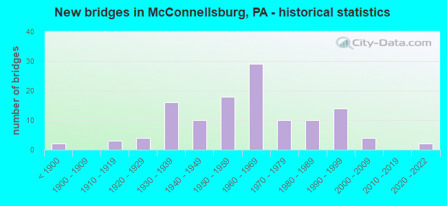
- New bridges - historical statistics
- 2Before 1900
- 31910-1919
- 41920-1929
- 161930-1939
- 101940-1949
- 181950-1959
- 291960-1969
- 101970-1979
- 101980-1989
- 141990-1999
- 42000-2009
- 22020-2022

- Reconstructed bridges - Historical Statistics
- 11920-1929
- 01930-1939
- 21940-1949
- 01950-1959
- 01960-1969
- 41970-1979
- 91980-1989
- 61990-1999
- 132000-2009
- 32010-2019
- 22020-2022


- Bridge Condition - Deck
- 1.0%Excellent
- 8.7%Very good
- 36.5%Good
- 25.0%Satisfactory
- 24.0%Fair
- 4.8%Poor

- Bridge Condition - Superstructure
- 2.8%Excellent
- 9.2%Very good
- 27.5%Good
- 27.5%Satisfactory
- 19.3%Fair
- 11.0%Poor
- 1.8%Serious
- 0.9%Critical

- Bridge Condition - Substructure
- 32.1%Excellent
- 27.5%Very good
- 31.2%Good
- 7.3%Satisfactory
- 1.8%Fair
- 7.3%Poor

- Bridge Condition - Channel
- 9.6%Very good
- 10.8%Good
- 30.1%Satisfactory
- 32.5%Fair
- 15.7%Poor
- 1.2%Serious

- Bridge Condition - Culverts
- 55.6%Good
- 22.2%Satisfactory
- 11.1%Fair
- 11.1%Critical
Find on map >> Show street view
Structure Number: 3745, Location: EXIT-22, I-83 & PA 181 (Lat: 39.991569, Lng: -76.734419), Route carried "on" structure: Interstate 83, Year Built: 1957, Year Reconstructed: 1984, Status: Open, Structure Length: 7.16m (23.49ft), Average Daily Traffic: 51,776 (year 2020), Truck Traffic: 15%, Average Future Daily Traffic: 65,922 (year 2035), Design Load: HS 20, Features Intersected: 181 George St
Minimum Vertical Clearance: 30+ m (98+ ft), Kilometerpoint: 34.517, Lanes on structure: 4, Lanes under structure: 8, Base Highway Network: Yes, Owner: State Highway Agency, Approaching Roadway Width: 21.9m (71.9ft), Skew: 34 degrees, Material/Design: Steel continuous, Design/Construction: Stringer/Multi-beam, Number Of Spans In Main Unit: 3, Length of Maximum Span: 26.5m (86.9ft), Curb or Sidewalk Widths: Left: 0.2m (0.7ft), Right: 0.2m (0.7ft), Curb-To-Curb Width: 20.7m (67.9ft), Out-to-Out Width: 21.9m (71.9ft)
Condition: Deck: Fair, Superstructure: Poor, Substructure: Fair, Operating Rating: 79.8 metric tons, Method Used To Determine Operating Rating: Load Factor (LF), Inventory Rating: 48.1 metric tons, Method Used To Determine Inventory Rating: Load Factor (LF), Structural Evaluation: Meets minimum limits, Deck Geometry: Equal to present minimum criteria, Underclear: Equal to present minimum criteria, Approach Roadway Alignment: Equal to present desirable criteria, Length Of Structure Improvement: 8.10m (26.57ft), Designated Inspection Frequency: Every 24 months, Inspection Date: October 2019, Bridge Improvement Cost: $97,000, Roadway Improvement Cost: $284,000, Total Project Cost: $1,304,000, Deck Structure Type: Concrete Cast-file-Place, Wearing Surface/Protective System: Wearing Surface: Bituminous, Membrane: Preformed Fabric
Find on map >> Show street view
Structure Number: 3762, Location: LONG LEVEL (Lat: 39.969919, Lng: -76.492125), Route carried "on" structure: State highway 624, Year Built: 1931, Status: Open, Structure Length: 1.52m (4.99ft), Average Daily Traffic: 2,838 (year 2020), Truck Traffic: 8%, Average Future Daily Traffic: 3,265 (year 2032), Design Load: H 20, Features Intersected: CABIN CREEK
Minimum Vertical Clearance: 30+ m (98+ ft), Kilometerpoint: 13.311, Lanes on structure: 2, Owner: State Highway Agency, Approaching Roadway Width: 6.1m (20.0ft), Material/Design: Concrete, Design/Construction: Tee Beam, Number Of Spans In Main Unit: 1, Length of Maximum Span: 13.7m (44.9ft), Curb or Sidewalk Widths: Left: 0.2m (0.7ft), Right: 0.2m (0.7ft), Curb-To-Curb Width: 7.1m (23.3ft), Out-to-Out Width: 7.9m (25.9ft)
Condition: Deck: Fair, Superstructure: Fair, Substructure: Fair, Channel: Poor, Operating Rating: 51.7 metric tons, Method Used To Determine Operating Rating: Load Factor (LF), Inventory Rating: 30.8 metric tons, Method Used To Determine Inventory Rating: Load Factor (LF), Structural Evaluation: Somewhat better than minimum adequacy, Deck Geometry: High priority of replacement, Waterway Adequacy: Equal to present minimum criteria, Approach Roadway Alignment: Equal to present desirable criteria, Length Of Structure Improvement: 2.20m (7.22ft), Designated Inspection Frequency: Every 24 months, Underwater Inspection Frequency: Every 24 months, Inspection Date: August 2021, Underwater Inspection Date: July 2021, Bridge Improvement Cost: $15,000, Roadway Improvement Cost: $45,000, Total Project Cost: $205,000, Deck Structure Type: Concrete Cast-file-Place, Wearing Surface/Protective System: Wearing Surface: Bituminous
Find on map >> Show street view
Structure Number: 3763, Location: 1 MI.W. OF STEWWARTSTOWN (Lat: 39.756967, Lng: -76.610519), Route carried "on" structure: State highway 851, Year Built: 1961, Status: Open, Structure Length: 0.64m (2.10ft), Average Daily Traffic: 8,837 (year 2022), Truck Traffic: 10%, Average Future Daily Traffic: 12,248 (year 2032), Design Load: HS 20, Features Intersected: W BR OF DEER CREEK
Minimum Vertical Clearance: 30+ m (98+ ft), Kilometerpoint: 23.253, Lanes on structure: 2, Base Highway Network: Yes, Owner: State Highway Agency, Approaching Roadway Width: 9.8m (32.2ft), Skew: 3 degrees, Material/Design: Concrete, Design/Construction: Culvert, Number Of Spans In Main Unit: 1, Length of Maximum Span: 6.4m (21.0ft)
Condition: Channel: Fair, Culverts: Fair, Operating Rating: 42.6 metric tons, Method Used To Determine Operating Rating: Load Factor (LF), Inventory Rating: 25.4 metric tons, Method Used To Determine Inventory Rating: Load Factor (LF), Structural Evaluation: Somewhat better than minimum adequacy, Waterway Adequacy: Superior to present desirable criteria, Approach Roadway Alignment: Equal to present desirable criteria, Length Of Structure Improvement: 1.20m (3.94ft), Designated Inspection Frequency: Every 24 months, Inspection Date: July 2021, Bridge Improvement Cost: $10,000, Roadway Improvement Cost: $29,000, Total Project Cost: $133,000
Find on map >> Show street view
Structure Number: 3764, Location: 0.6 MI.E. DOVER BORO LINE (Lat: 40.007294, Lng: -76.830681), Route carried "on" structure: State highway 921, Year Built: 1937, Year Reconstructed: 1983, Status: Open, Structure Length: 1.43m (4.69ft), Average Daily Traffic: 6,170 (year 2021), Truck Traffic: 7%, Average Future Daily Traffic: 8,996 (year 2032), Design Load: HS 20+Mod, Features Intersected: FOX RUN
Minimum Vertical Clearance: 30+ m (98+ ft), Kilometerpoint: 1.876, Lanes on structure: 2, Owner: State Highway Agency, Approaching Roadway Width: 7.3m (24.0ft), Material/Design: Prestressed concrete, Design/Construction: Box Beam or Girders - Multiple, Number Of Spans In Main Unit: 1, Length of Maximum Span: 13.4m (44.0ft), Curb or Sidewalk Widths: Left: 0.2m (0.7ft), Right: 0.2m (0.7ft), Curb-To-Curb Width: 8.7m (28.5ft), Out-to-Out Width: 9.8m (32.2ft)
Condition: Deck: Poor, Superstructure: Poor, Substructure: Satisfactory, Channel: Satisfactory, Operating Rating: 47.2 metric tons, Method Used To Determine Operating Rating: Load Factor (LF), Structural Evaluation: High priority of corrective action, Deck Geometry: High priority of replacement, Waterway Adequacy: Equal to present minimum criteria, Approach Roadway Alignment: Equal to present desirable criteria, Length Of Structure Improvement: 2.10m (6.89ft), Designated Inspection Frequency: Every 24 months, Inspection Date: November 2019, Bridge Improvement Cost: $5,000, Roadway Improvement Cost: $14,000, Total Project Cost: $65,000, Deck Structure Type: Other, Wearing Surface/Protective System: Wearing Surface: Bituminous, Membrane: Preformed Fabric
Find on map >> Show street view
Structure Number: 3809, Location: 2.6S DOVER/LITTLE CONOWAG (Lat: 39.965300, Lng: -76.824667), Route carried "on" structure: City street , Year Built: 1954, Status: Posted for load, Structure Length: 1.52m (4.99ft), Average Daily Traffic: 5,920 (year 2019), Truck Traffic: 10%, Average Future Daily Traffic: 6,779 (year 2039), Design Load: HS 20, Features Intersected: LITTLE CONEWAGO CREEK, Facility Carried by Structure: BAKER ROAD
Minimum Vertical Clearance: 30+ m (98+ ft), Kilometerpoint: 0.000, Lanes on structure: 1, Owner: County Highway Agency, Approaching Roadway Width: 7.3m (24.0ft), Material/Design: Prestressed concrete, Design/Construction: Box Beam or Girders - Multiple, Number Of Spans In Main Unit: 1, Length of Maximum Span: 14.3m (46.9ft), Curb-To-Curb Width: 5.2m (17.1ft), Out-to-Out Width: 5.6m (18.4ft)
Condition: Deck: Satisfactory, Superstructure: Poor, Substructure: Fair, Channel: Satisfactory, Operating Rating: 37.2 metric tons, Method Used To Determine Operating Rating: Load Factor (LF), Inventory Rating: 17.2 metric tons, Method Used To Determine Inventory Rating: Load Factor (LF), Structural Evaluation: Meets minimum limits, Deck Geometry: High priority of replacement, Waterway Adequacy: Equal to present minimum criteria, Approach Roadway Alignment: High priority of corrective action, Bridge Posting: Required (Relationship of Operating Rating to Maximum Legal Load: 0.1 - 9.9% below), Length Of Structure Improvement: 2.20m (7.22ft), Designated Inspection Frequency: Every 24 months, Other Special Inspection Frequency: Every 12 months, Inspection Date: March 2021, Other Special Inspection Date: March 2021, Bridge Improvement Cost: $34,000, Roadway Improvement Cost: $99,000, Total Project Cost: $454,000, Deck Structure Type: Concrete Cast-file-Place, Wearing Surface/Protective System: Wearing Surface: Monolithic Concrete, Deck Protection: Epoxy Coated Reinforcing
Find on map >> Show street view
Structure Number: 42173, Location: 1 MI.S OF MCCONNELLSBURG (Lat: 39.924675, Lng: -77.999558), Route carried "on" structure: State highway , Year Built: 2002, Status: Open, Structure Length: 0.61m (2.00ft), Average Daily Traffic: 2,729 (year 2020), Truck Traffic: 8%, Average Future Daily Traffic: 2,859 (year 2040), Design Load: HL 93, Features Intersected: TRIB BIG COVE CREEK, Facility Carried by Structure: SR 1016
Minimum Vertical Clearance: 30+ m (98+ ft), Kilometerpoint: 0.000, Lanes on structure: 2, Owner: State Highway Agency, Approaching Roadway Width: 11.0m (36.1ft), Skew: 3 degrees, Material/Design: Concrete, Design/Construction: Culvert, Number Of Spans In Main Unit: 1, Length of Maximum Span: 2.4m (7.9ft)
Condition: Channel: Satisfactory, Culverts: Good, Operating Rating: 82.6 metric tons, Method Used To Determine Operating Rating: Load and Resistance Factor (LRFR), Inventory Rating: 63.5 metric tons, Method Used To Determine Inventory Rating: Load and Resistance Factor (LRFR), Structural Evaluation: Better than present minimum criteria, Waterway Adequacy: Better than present minimum criteria, Approach Roadway Alignment: Equal to present desirable criteria, Designated Inspection Frequency: Every 47 months, Inspection Date: April 2020
Find on map >> Show street view
Structure Number: 6853, Location: 1.1MI W. OF PA611 (Lat: 40.943897, Lng: -75.134389), Route carried "on" structure: City street , Year Built: 2021, Status: Open, Structure Length: 0.67m (2.20ft), Average Daily Traffic: 100 (year 2021), Average Future Daily Traffic: 100 (year 2021), Design Load: HL 93, Features Intersected: SLATEFORD CREEK, Facility Carried by Structure: LAUREL HILL RD.
Minimum Vertical Clearance: 30+ m (98+ ft), Kilometerpoint: 0.000, Lanes on structure: 2, Owner: County Highway Agency, Approaching Roadway Width: 4.6m (15.1ft), Material/Design: Concrete, Design/Construction: Arch - Deck, Number Of Spans In Main Unit: 1, Length of Maximum Span: 6.7m (22.0ft), Curb-To-Curb Width: 7.3m (24.0ft), Out-to-Out Width: 8.4m (27.6ft)
Condition: Superstructure: Excellent, Substructure: Excellent, Channel: Very good, Operating Rating: 41.1 metric tons, Method Used To Determine Operating Rating: Assigned ratings based on Load and Resistance Factor Design (LRFD) reported by rating factor (RF) using HL93 loadings, Inventory Rating: 32.4 metric tons, Method Used To Determine Inventory Rating: Assigned ratings based on Load and Resistance Factor Design (LRFD) reported by rating factor (RF) using HL93 loadings, Structural Evaluation: Equal to present desirable criteria, Deck Geometry: Equal to present minimum criteria, Waterway Adequacy: Better than present minimum criteria, Approach Roadway Alignment: Equal to present desirable criteria, Designated Inspection Frequency: Every 24 months, Inspection Date: October 2021
Find on map >> Show street view
Structure Number: 17782, Location: OVER TR 522 (Lat: 39.943500, Lng: -77.993522), Route carried "under" structure: US 522, Year Built: 1966, Structure Length: 0. m, Average Daily Traffic: 2,582 (year 2021), Truck Traffic: 11%, Features Intersected: US 522, Facility Carried by Structure: US 30
Minimum Vertical Clearance: 4.60m (15.09ft), Kilometerpoint: 35.092, Lanes on structure: 4, Lanes under structure: 3, Material/Design: Prestressed concrete, Design/Construction: Stringer/Multi-beam, Length of Maximum Span: 30.8m (101.0ft)
Find on map >> Show street view
Structure Number: 17782, Location: OVER TR 522 (Lat: 39.943500, Lng: -77.993522), Route carried "under" structure: US 522, Year Built: 1966, Structure Length: 0. m, Average Daily Traffic: 2,582 (year 2021), Truck Traffic: 11%, Features Intersected: US 522, Facility Carried by Structure: US 30
Minimum Vertical Clearance: 4.43m (14.53ft), Kilometerpoint: 35.092, Lanes on structure: 4, Lanes under structure: 2, Material/Design: Prestressed concrete, Design/Construction: Stringer/Multi-beam, Length of Maximum Span: 30.8m (101.0ft)
Find on map >> Show street view
Structure Number: 17877, Location: OVER US 30 (Lat: 39.944175, Lng: -78.009156), Route carried "under" structure: US 30, Year Built: 1966, Structure Length: 0. m, Average Daily Traffic: 1,834 (year 2022), Truck Traffic: 8%, Features Intersected: US 30, Facility Carried by Structure: T516 PEACH ORCHARD
Minimum Vertical Clearance: 4.52m (14.83ft), Kilometerpoint: 22.948, Lanes on structure: 2, Lanes under structure: 3, Material/Design: Prestressed concrete, Design/Construction: Box Beam or Girders - Single/Spread, Length of Maximum Span: 20.7m (67.9ft)
Find on map >> Show street view
Structure Number: 17879, Location: 1.5 MI.W.OF MCCONNELSBURG (Lat: 39.938056, Lng: -78.016731), Route carried "under" structure: US 30, Year Built: 1966, Structure Length: 0. m, Average Daily Traffic: 1,834 (year 2022), Truck Traffic: 8%, Features Intersected: US 30, Facility Carried by Structure: SR 1004
Minimum Vertical Clearance: 7.62m (25.00ft), Kilometerpoint: 21.984, Lanes on structure: 2, Lanes under structure: 3, Material/Design: Prestressed concrete, Design/Construction: Box Beam or Girders - Single/Spread, Length of Maximum Span: 22.6m (74.1ft)