Bridge Statistics for McPherson, Kansas (KS)
Condition, Traffic, Stress, Structural Evaluation, Project Costs
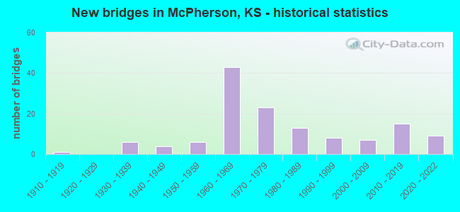
- New bridges - historical statistics
- 11910-1919
- 61930-1939
- 41940-1949
- 61950-1959
- 431960-1969
- 231970-1979
- 131980-1989
- 81990-1999
- 72000-2009
- 152010-2019
- 92020-2022
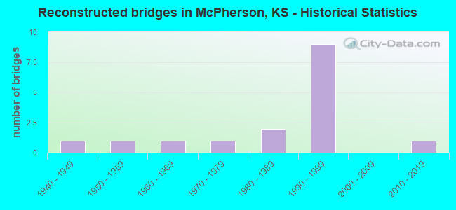
- Reconstructed bridges - Historical Statistics
- 11940-1949
- 11950-1959
- 11960-1969
- 11970-1979
- 21980-1989
- 91990-1999
- 02000-2009
- 12010-2019
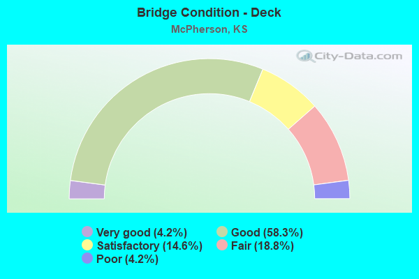
- Bridge Condition - Deck
- 4.2%Very good
- 58.3%Good
- 14.6%Satisfactory
- 18.8%Fair
- 4.2%Poor
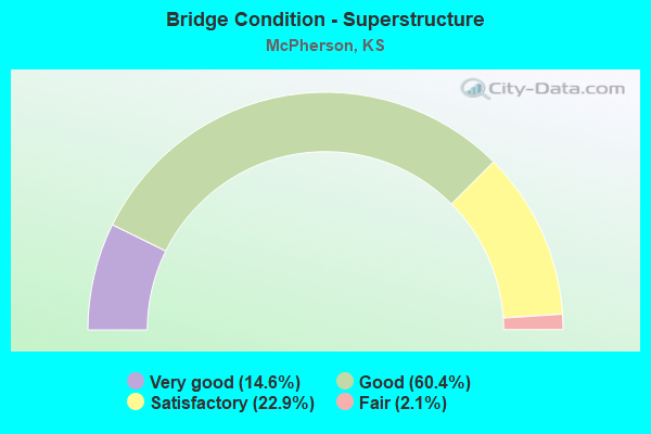
- Bridge Condition - Superstructure
- 14.6%Very good
- 60.4%Good
- 22.9%Satisfactory
- 2.1%Fair
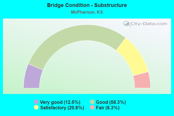
- Bridge Condition - Substructure
- 12.5%Very good
- 58.3%Good
- 20.8%Satisfactory
- 8.3%Fair
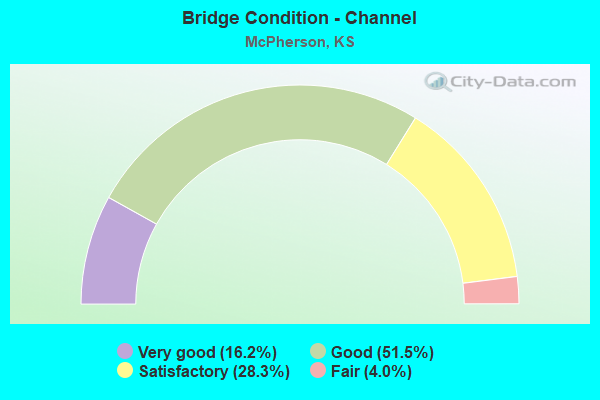
- Bridge Condition - Channel
- 16.2%Very good
- 51.5%Good
- 28.3%Satisfactory
- 4.0%Fair
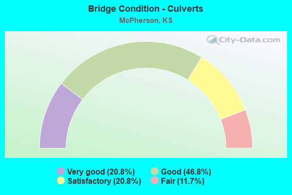
- Bridge Condition - Culverts
- 20.8%Very good
- 46.8%Good
- 20.8%Satisfactory
- 11.7%Fair
Find on map >> Show street view
Structure Number: 999913500590221, Location: 8.21 MI N NJCT K260 (Lat: 38.318333, Lng: -97.619722), Route carried "under" structure: Interstate 135, Year Built: 1971, Structure Length: 0. m, Average Daily Traffic: 5,110 (year 2020), Truck Traffic: 36%, Features Intersected: I135 HWY NB/SB, Facility Carried by Structure: LOCAL ROAD
Minimum Vertical Clearance: 4.99m (16.37ft), Kilometerpoint: 22.190, Lanes on structure: 2, Lanes under structure: 4, Material/Design: Steel continuous, Design/Construction: Stringer/Multi-beam, Length of Maximum Span: 28.3m (92.8ft)
Find on map >> Show street view
Structure Number: 999913500590341, Location: 1.40 MI N US56 (Lat: 38.391111, Lng: -97.620556), Route carried "under" structure: Interstate 135, Year Built: 1969, Structure Length: 0. m, Average Daily Traffic: 7,194 (year 2020), Truck Traffic: 27%, Features Intersected: I135 HWY WL-EL, Facility Carried by Structure: LOCAL ROAD
Minimum Vertical Clearance: 4.96m (16.27ft), Kilometerpoint: 30.277, Lanes on structure: 2, Lanes under structure: 4, Material/Design: Concrete continuous, Design/Construction: Box Beam or Girders - Multiple, Length of Maximum Span: 20.7m (67.9ft)
Find on map >> Show street view
Structure Number: 999913500590361, Location: 3.40 MI N US56 (Lat: 38.420000, Lng: -97.620556), Route carried "under" structure: Interstate 135, Year Built: 1968, Structure Length: 0. m, Average Daily Traffic: 5,514 (year 2020), Truck Traffic: 37%, Features Intersected: I135 HWY WL-EL, Facility Carried by Structure: LOCAL ROAD
Minimum Vertical Clearance: 4.95m (16.24ft), Kilometerpoint: 33.494, Lanes on structure: 2, Lanes under structure: 4, Material/Design: Concrete continuous, Design/Construction: Box Beam or Girders - Multiple, Length of Maximum Span: 20.7m (67.9ft)
Find on map >> Show street view
Structure Number: 999913500591421, Location: 2.0 MI N US56 (Lat: 38.405556, Lng: -97.620556), Route carried "under" structure: Interstate 135, Year Built: 2017, Structure Length: 0. m, Average Daily Traffic: 7,194 (year 2020), Truck Traffic: 27%, Features Intersected: I135 HWY, Facility Carried by Structure: MOHAWK ROAD
Minimum Vertical Clearance: 5.20m (17.06ft), Kilometerpoint: 31.920, Lanes under structure: 4, Material/Design: Prestressed concrete continuous, Design/Construction: Stringer/Multi-beam, Length of Maximum Span: 27.7m (90.9ft)
Find on map >> Show street view
Structure Number: 999913500591431, Location: 1.52 MI N US81 ALT (Lat: 38.362222, Lng: -97.620556), Route carried "under" structure: Interstate 135, Year Built: 2021, Structure Length: 0. m, Average Daily Traffic: 10,928 (year 2020), Truck Traffic: 17%, Features Intersected: I-135, Facility Carried by Structure: Avenue A
Minimum Vertical Clearance: 4.90m (16.08ft), Kilometerpoint: 27.060, Lanes on structure: 4, Lanes under structure: 4, Material/Design: Steel continuous, Design/Construction: Stringer/Multi-beam, Length of Maximum Span: 38.7m (127.0ft)