Bridge Statistics for Millbrae, California (CA)
Condition, Traffic, Stress, Structural Evaluation, Project Costs
- National Bridge Inventory (NBI) Statistics
- 71Number of bridges
- 2,352ft / 717mTotal length
- $54,891,000Total costs
- 2,735,075Total average daily traffic
- 100,951Total average daily truck traffic
- National Bridge Inventory (NBI) Registered Bridges for Millbrae
- No street view available for this location
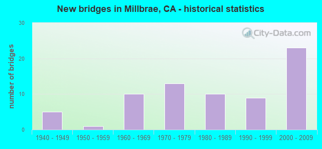
- New bridges - historical statistics
- 51940-1949
- 11950-1959
- 101960-1969
- 131970-1979
- 101980-1989
- 91990-1999
- 232000-2009
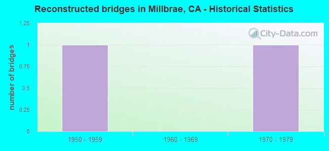
- Reconstructed bridges - Historical Statistics
- 11950-1959
- 01960-1969
- 11970-1979
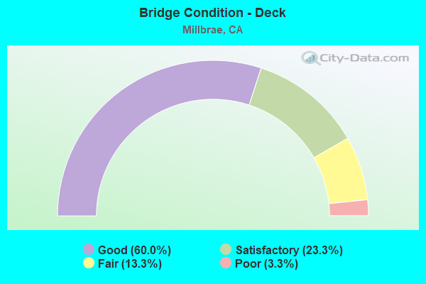
- Bridge Condition - Deck
- 60.0%Good
- 23.3%Satisfactory
- 13.3%Fair
- 3.3%Poor
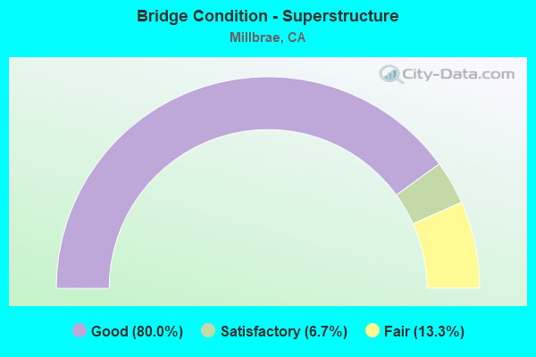
- Bridge Condition - Superstructure
- 80.0%Good
- 6.7%Satisfactory
- 13.3%Fair
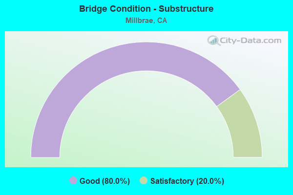
- Bridge Condition - Substructure
- 80.0%Good
- 20.0%Satisfactory
Find on map >> Show street view
Structure Number: 35 0081G, Location: 04-SM-101-5.39-RDWC (Lat: 37.490100, Lng: -122.211608), Route carried "on" structure: Ramp US 101, Year Built: 1958, Status: Open, Structure Length: 5.21m (17.09ft), Average Daily Traffic: 12,600 (year 1998), Truck Traffic: 2%, Average Future Daily Traffic: 27,114 (year 2037), Design Load: HS 20, Features Intersected: WOODSIDE ROAD
Minimum Vertical Clearance: 30+ m (98+ ft), Kilometerpoint: 5.390, Lanes on structure: 1, Lanes under structure: 4, Base Highway Network: Yes, Owner: State Highway Agency, Approaching Roadway Width: 4.9m (16.1ft), Skew: 3 degrees, Material/Design: Concrete continuous, Design/Construction: Slab, Number Of Spans In Main Unit: 4, Length of Maximum Span: 14.6m (47.9ft), Curb or Sidewalk Widths: Left: 0.6m (2.0ft), Right: 0.6m (2.0ft), Curb-To-Curb Width: 6.7m (22.0ft), Out-to-Out Width: 7.9m (25.9ft)
Condition: Deck: Good, Superstructure: Good, Substructure: Good, Operating Rating: 46.3 metric tons, Method Used To Determine Operating Rating: Load and Resistance Factor Rating (LRFR) rating reported by rating factor(RF) method using HL-93 loadings, Inventory Rating: 35.6 metric tons, Method Used To Determine Inventory Rating: Load and Resistance Factor Rating (LRFR) rating reported by rating factor(RF) method using HL-93 loadings, Structural Evaluation: Better than present minimum criteria, Deck Geometry: Equal to present minimum criteria, Underclear: Meets minimum limits, Approach Roadway Alignment: Meets minimum limits, Designated Inspection Frequency: Every 48 months, Inspection Date: August 2019, Deck Structure Type: Concrete Cast-file-Place
Find on map >> Show street view
Structure Number: 35 0089, Location: 04-SM-101-17.95-MLBR (Lat: 37.601842, Lng: -122.381433), Route carried "on" structure: City street D007, Year Built: 1947, Year Reconstructed: 1976, Status: Open, Structure Length: 24.85m (81.53ft), Average Daily Traffic: 53,747 (year 1999), Truck Traffic: 5%, Average Future Daily Traffic: 74,818 (year 2038), Design Load: HS 20, Features Intersected: U.S. HIGHWAY 101, Facility Carried by Structure: MILLBRAE AVENUE
Minimum Vertical Clearance: 30+ m (98+ ft), Kilometerpoint: 0.000, Lanes on structure: 5, Lanes under structure: 10, Base Highway Network: Yes, Owner: State Highway Agency, Approaching Roadway Width: 22.5m (73.8ft), Skew: 21 degrees, Material/Design: Steel, Design/Construction: Stringer/Multi-beam, Number Of Spans In Main Unit: 14, Length of Maximum Span: 23.0m (75.5ft), Curb or Sidewalk Widths: Left: 0.0m, Right: 1.5m (4.9ft), Curb-To-Curb Width: 22.5m (73.8ft), Out-to-Out Width: 24.8m (81.4ft)
Condition: Deck: Fair, Superstructure: Good, Substructure: Good, Operating Rating: 36.0 metric tons, Method Used To Determine Operating Rating: Load and Resistance Factor Rating (LRFR) rating reported by rating factor(RF) method using HL-93 loadings, Inventory Rating: 15.9 metric tons, Method Used To Determine Inventory Rating: Load and Resistance Factor Rating (LRFR) rating reported by rating factor(RF) method using HL-93 loadings, Structural Evaluation: High priority of corrective action, Deck Geometry: Equal to present minimum criteria, Underclear: Meets minimum limits, Approach Roadway Alignment: Equal to present desirable criteria, Designated Inspection Frequency: Every 24 months, Other Special Inspection Frequency: Every 48 months, Inspection Date: April 2021, Other Special Inspection Date: November 2021, Deck Structure Type: Concrete Cast-file-Place
Find on map >> Show street view
Structure Number: 35 0126, Location: 04-SM-101-18.09-MLBR (Lat: 37.604061, Lng: -122.382264), Route carried "on" structure: US 101, Year Built: 1947, Year Reconstructed: 1961, Status: Open, Structure Length: 1.04m (3.41ft), Average Daily Traffic: 226,000 (year 2009), Truck Traffic: 4%, Average Future Daily Traffic: 279,030 (year 2038), Features Intersected: MILLBRAE SLOUGH
Minimum Vertical Clearance: 30+ m (98+ ft), Kilometerpoint: 18.090, Lanes on structure: 12, Base Highway Network: Yes (Inventory Route: 1, Subroute: 1), Owner: State Highway Agency, Approaching Roadway Width: 25.6m (84.0ft), Skew: 31 degrees, Material/Design: Concrete continuous, Design/Construction: Culvert, Number Of Spans In Main Unit: 3, Length of Maximum Span: 3.0m (9.8ft)
Condition: Channel: Good, Culverts: Fair, Operating Rating: 54.1 metric tons, Method Used To Determine Operating Rating: Field evaluation and documented engineering judgment, Inventory Rating: 32.4 metric tons, Method Used To Determine Inventory Rating: Field evaluation and documented engineering judgment, Structural Evaluation: Somewhat better than minimum adequacy, Waterway Adequacy: Equal to present desirable criteria, Approach Roadway Alignment: Equal to present desirable criteria, Designated Inspection Frequency: Every 24 months, Inspection Date: April 2021
Find on map >> Show street view
Structure Number: 35 0211L, Location: 04-SM-280-R17.92-MLBR (Lat: 37.589114, Lng: -122.412458), Route carried "on" structure: Interstate 280, Year Built: 1969, Status: Open, Structure Length: 2.84m (9.32ft), Average Daily Traffic: 54,500 (year 2009), Average Future Daily Traffic: 74,148 (year 2038), Design Load: HS 20, Features Intersected: HILLCREST BOULEVARD
Minimum Vertical Clearance: 30+ m (98+ ft), Kilometerpoint: 17.920, Lanes on structure: 4, Lanes under structure: 2, Base Highway Network: Yes (Inventory Route: 2, Subroute: 1), Owner: State Highway Agency, Approaching Roadway Width: 20.1m (65.9ft), Material/Design: Prestressed concrete, Design/Construction: Box Beam or Girders - Multiple, Number Of Spans In Main Unit: 1, Length of Maximum Span: 27.7m (90.9ft), Curb-To-Curb Width: 20.1m (65.9ft), Out-to-Out Width: 21.2m (69.6ft)
Condition: Deck: Satisfactory, Superstructure: Good, Substructure: Good, Operating Rating: 99.8 metric tons, Method Used To Determine Operating Rating: Load Factor (LF), Inventory Rating: 32.4 metric tons, Method Used To Determine Inventory Rating: Load Factor (LF), Structural Evaluation: Better than present minimum criteria, Deck Geometry: Equal to present minimum criteria, Underclear: High priority of corrective action, Approach Roadway Alignment: Equal to present desirable criteria, Designated Inspection Frequency: Every 48 months, Inspection Date: July 2021, Deck Structure Type: Concrete Cast-file-Place
Find on map >> Show street view
Structure Number: 35 0211R, Location: 04-SM-280-R17.92-MLBR (Lat: 37.589261, Lng: -122.412219), Route carried "on" structure: Interstate 280, Year Built: 1969, Status: Open, Structure Length: 2.84m (9.32ft), Average Daily Traffic: 54,500 (year 2009), Average Future Daily Traffic: 74,148 (year 2038), Design Load: HS 20, Features Intersected: HILLCREST BOULEVARD
Minimum Vertical Clearance: 30+ m (98+ ft), Kilometerpoint: 17.920, Lanes on structure: 4, Lanes under structure: 2, Base Highway Network: Yes (Inventory Route: 2, Subroute: 1), Owner: State Highway Agency, Approaching Roadway Width: 20.1m (65.9ft), Material/Design: Prestressed concrete, Design/Construction: Box Beam or Girders - Multiple, Number Of Spans In Main Unit: 1, Length of Maximum Span: 27.7m (90.9ft), Curb-To-Curb Width: 20.1m (65.9ft), Out-to-Out Width: 21.2m (69.6ft)
Condition: Deck: Satisfactory, Superstructure: Good, Substructure: Good, Operating Rating: 99.8 metric tons, Method Used To Determine Operating Rating: Load Factor (LF), Inventory Rating: 32.4 metric tons, Method Used To Determine Inventory Rating: Load Factor (LF), Structural Evaluation: Better than present minimum criteria, Deck Geometry: Equal to present minimum criteria, Underclear: High priority of corrective action, Approach Roadway Alignment: Equal to present desirable criteria, Designated Inspection Frequency: Every 48 months, Inspection Date: July 2021, Deck Structure Type: Concrete Cast-file-Place
Find on map >> Show street view
Structure Number: 35 0216L, Location: 04-SM-280-R18.52-MLBR (Lat: 37.596003, Lng: -122.419258), Route carried "on" structure: Interstate 280, Year Built: 1969, Status: Open, Structure Length: 3.02m (9.91ft), Average Daily Traffic: 51,500 (year 2009), Average Future Daily Traffic: 70,297 (year 2038), Design Load: HS 20, Features Intersected: LARKSPUR DRIVE
Minimum Vertical Clearance: 30+ m (98+ ft), Kilometerpoint: 18.520, Lanes on structure: 4, Lanes under structure: 2, Base Highway Network: Yes (Inventory Route: 2, Subroute: 1), Owner: State Highway Agency, Approaching Roadway Width: 20.1m (65.9ft), Material/Design: Prestressed concrete, Design/Construction: Box Beam or Girders - Multiple, Number Of Spans In Main Unit: 1, Length of Maximum Span: 29.4m (96.5ft), Curb-To-Curb Width: 20.1m (65.9ft), Out-to-Out Width: 21.2m (69.6ft)
Condition: Deck: Good, Superstructure: Good, Substructure: Good, Operating Rating: 83.6 metric tons, Method Used To Determine Operating Rating: Load Factor (LF), Inventory Rating: 32.4 metric tons, Method Used To Determine Inventory Rating: Load Factor (LF), Structural Evaluation: Better than present minimum criteria, Deck Geometry: Equal to present minimum criteria, Underclear: Somewhat better than minimum adequacy, Approach Roadway Alignment: Equal to present desirable criteria, Designated Inspection Frequency: Every 48 months, Inspection Date: July 2021, Deck Structure Type: Concrete Cast-file-Place
Find on map >> Show street view
Structure Number: 35 0216R, Location: 04-SM-280-R18.52-MLBR (Lat: 37.596128, Lng: -122.419017), Route carried "on" structure: Interstate 280, Year Built: 1969, Status: Open, Structure Length: 2.87m (9.42ft), Average Daily Traffic: 51,500 (year 2009), Average Future Daily Traffic: 70,297 (year 2038), Design Load: HS 20+Mod, Features Intersected: LARKSPUR DRIVE
Minimum Vertical Clearance: 30+ m (98+ ft), Kilometerpoint: 18.520, Lanes on structure: 4, Lanes under structure: 2, Base Highway Network: Yes (Inventory Route: 2, Subroute: 1), Owner: State Highway Agency, Approaching Roadway Width: 20.1m (65.9ft), Skew: 1 degrees, Material/Design: Prestressed concrete, Design/Construction: Box Beam or Girders - Multiple, Number Of Spans In Main Unit: 1, Length of Maximum Span: 27.9m (91.5ft), Curb-To-Curb Width: 20.1m (65.9ft), Out-to-Out Width: 21.2m (69.6ft)
Condition: Deck: Satisfactory, Superstructure: Good, Substructure: Good, Operating Rating: 99.8 metric tons, Method Used To Determine Operating Rating: Load Factor (LF), Inventory Rating: 32.4 metric tons, Method Used To Determine Inventory Rating: Load Factor (LF), Structural Evaluation: Better than present minimum criteria, Deck Geometry: Equal to present minimum criteria, Underclear: Somewhat better than minimum adequacy, Approach Roadway Alignment: Equal to present desirable criteria, Designated Inspection Frequency: Every 48 months, Inspection Date: July 2021, Deck Structure Type: Concrete Cast-file-Place
Find on map >> Show street view
Structure Number: 35 0274K, Location: 04-SM-101-19.09 (Lat: 37.611853, Lng: -122.395408), Route carried "on" structure: Ramp US 101, Year Built: 1987, Status: Open, Structure Length: 33.08m (108.53ft), Average Daily Traffic: 16,900 (year 1998), Truck Traffic: 5%, Average Future Daily Traffic: 27,255 (year 2038), Design Load: HS 20+Mod, Features Intersected: U.S. HIGHWAY 101
Minimum Vertical Clearance: 5.38m (17.65ft), Kilometerpoint: 19.090, Lanes on structure: 2, Lanes under structure: 12, Base Highway Network: Yes, Owner: State Highway Agency, Approaching Roadway Width: 11.0m (36.1ft), Material/Design: Prestressed concrete continuous, Design/Construction: Box Beam or Girders - Multiple, Number Of Spans In Main Unit: 3, Number Of Approach Spans: 5, Length of Maximum Span: 66.0m (216.5ft), Curb-To-Curb Width: 11.0m (36.1ft), Out-to-Out Width: 11.8m (38.7ft)
Condition: Deck: Satisfactory, Superstructure: Good, Substructure: Good, Operating Rating: 54.1 metric tons, Method Used To Determine Operating Rating: Assigned rating based on Load Factor Design (LFD) reported in metric tons, Inventory Rating: 32.4 metric tons, Method Used To Determine Inventory Rating: Assigned rating based on Load Factor Design (LFD) reported in metric tons, Structural Evaluation: Better than present minimum criteria, Deck Geometry: Better than present minimum criteria, Underclear: High priority of corrective action, Approach Roadway Alignment: Equal to present minimum criteria, Designated Inspection Frequency: Every 24 months, Inspection Date: April 2021, Deck Structure Type: Concrete Cast-file-Place
Find on map >> Show street view
Structure Number: 35 0275K, Location: 04-SM-101-19.26 (Lat: 37.614303, Lng: -122.393833), Route carried "on" structure: Ramp US 101, Year Built: 1987, Status: Open, Structure Length: 49.34m (161.88ft), Average Daily Traffic: 15,900 (year 1998), Truck Traffic: 2%, Average Future Daily Traffic: 27,255 (year 2038), Design Load: HS 20+Mod, Features Intersected: U.S. HIGHWAY 101
Minimum Vertical Clearance: 5.50m (18.04ft), Kilometerpoint: 19.260, Lanes on structure: 2, Lanes under structure: 17, Base Highway Network: Yes, Owner: State Highway Agency, Approaching Roadway Width: 11.9m (39.0ft), Material/Design: Prestressed concrete continuous, Design/Construction: Box Beam or Girders - Multiple, Number Of Spans In Main Unit: 10, Number Of Approach Spans: 6, Length of Maximum Span: 75.0m (246.1ft), Curb-To-Curb Width: 11.7m (38.4ft), Out-to-Out Width: 12.6m (41.3ft)
Condition: Deck: Satisfactory, Superstructure: Good, Substructure: Good, Operating Rating: 54.1 metric tons, Method Used To Determine Operating Rating: Assigned rating based on Load Factor Design (LFD) reported in metric tons, Inventory Rating: 32.4 metric tons, Method Used To Determine Inventory Rating: Assigned rating based on Load Factor Design (LFD) reported in metric tons, Structural Evaluation: Better than present minimum criteria, Deck Geometry: Superior to present desirable criteria, Underclear: Somewhat better than minimum adequacy, Approach Roadway Alignment: Equal to present minimum criteria, Designated Inspection Frequency: Every 24 months, Inspection Date: April 2021, Deck Structure Type: Concrete Cast-file-Place
Find on map >> Show street view
Structure Number: 35 0323K, Location: 04-SM-101-19.12 (Lat: 37.613608, Lng: -122.395692), Route carried "on" structure: Ramp US 101, Year Built: 2000, Status: Open, Structure Length: 47.75m (156.66ft), Average Daily Traffic: 8,000 (year 2000), Truck Traffic: 3%, Average Future Daily Traffic: 17,101 (year 2038), Design Load: HS 20+Mod, Features Intersected: US 101, 2 AIRPRT-S101 ON
Minimum Vertical Clearance: 5.92m (19.42ft), Kilometerpoint: 19.120, Lanes on structure: 2, Lanes under structure: 17, Base Highway Network: Yes (Inventory Route: 1, Subroute: 1), Owner: State Highway Agency, Approaching Roadway Width: 11.5m (37.7ft), Material/Design: Prestressed concrete continuous, Design/Construction: Box Beam or Girders - Multiple, Number Of Spans In Main Unit: 13, Number Of Approach Spans: 6, Length of Maximum Span: 44.7m (146.7ft), Curb-To-Curb Width: 11.5m (37.7ft), Out-to-Out Width: 12.5m (41.0ft)
Condition: Deck: Good, Superstructure: Good, Substructure: Good, Operating Rating: 54.1 metric tons, Method Used To Determine Operating Rating: Assigned rating based on Load Factor Design (LFD) reported in metric tons, Inventory Rating: 32.4 metric tons, Method Used To Determine Inventory Rating: Assigned rating based on Load Factor Design (LFD) reported in metric tons, Structural Evaluation: Better than present minimum criteria, Deck Geometry: Superior to present desirable criteria, Underclear: Meets minimum limits, Approach Roadway Alignment: Equal to present desirable criteria, Designated Inspection Frequency: Every 24 months, Inspection Date: April 2021, Deck Structure Type: Concrete Cast-file-Place
Find on map >> Show street view
Structure Number: 35 0324K, Location: 04-SM-101-19.29 (Lat: 37.613147, Lng: -122.396764), Route carried "on" structure: Ramp Interstate 101, Year Built: 2000, Status: Open, Structure Length: 27.00m (88.58ft), Average Daily Traffic: 8,000 (year 2000), Truck Traffic: 2%, Average Future Daily Traffic: 17,101 (year 2038), Design Load: HS 20+Mod, Features Intersected: U.S. HIGHWAY 101
Minimum Vertical Clearance: 4.95m (16.24ft), Kilometerpoint: 19.290, Lanes on structure: 2, Lanes under structure: 10, Base Highway Network: Yes (Inventory Route: 1, Subroute: 1), Owner: State Highway Agency, Approaching Roadway Width: 10.8m (35.4ft), Material/Design: Prestressed concrete continuous, Design/Construction: Box Beam or Girders - Multiple, Number Of Spans In Main Unit: 6, Number Of Approach Spans: 5, Length of Maximum Span: 42.0m (137.8ft), Curb-To-Curb Width: 10.8m (35.4ft), Out-to-Out Width: 11.8m (38.7ft)
Condition: Deck: Good, Superstructure: Good, Substructure: Good, Operating Rating: 54.1 metric tons, Method Used To Determine Operating Rating: Assigned rating based on Load Factor Design (LFD) reported in metric tons, Inventory Rating: 32.4 metric tons, Method Used To Determine Inventory Rating: Assigned rating based on Load Factor Design (LFD) reported in metric tons, Structural Evaluation: Better than present minimum criteria, Deck Geometry: Somewhat better than minimum adequacy, Underclear: High priority of corrective action, Approach Roadway Alignment: Equal to present desirable criteria, Designated Inspection Frequency: Every 24 months, Inspection Date: April 2021, Deck Structure Type: Concrete Cast-file-Place
Find on map >> Show street view
Structure Number: 35 0327S, Location: 04-SM-101-18.54 (Lat: 37.608592, Lng: -122.388967), Route carried "on" structure: Ramp US 101, Year Built: 2000, Status: Open, Structure Length: 64.10m (210.30ft), Average Daily Traffic: 8,000 (year 2000), Truck Traffic: 3%, Average Future Daily Traffic: 17,101 (year 2038), Design Load: HS 20+Mod, Features Intersected: MILLBRAE AV-N101 ON RAMP
Minimum Vertical Clearance: 30+ m (98+ ft), Kilometerpoint: 18.540, Lanes on structure: 2, Lanes under structure: 3, Base Highway Network: Yes (Inventory Route: 1, Subroute: 1), Owner: State Highway Agency, Approaching Roadway Width: 13.0m (42.7ft), Material/Design: Prestressed concrete continuous, Design/Construction: Box Beam or Girders - Multiple, Number Of Spans In Main Unit: 14, Number Of Approach Spans: 20, Length of Maximum Span: 47.0m (154.2ft), Curb-To-Curb Width: 10.8m (35.4ft), Out-to-Out Width: 11.8m (38.7ft)
Condition: Deck: Good, Superstructure: Good, Substructure: Good, Operating Rating: 54.1 metric tons, Method Used To Determine Operating Rating: Assigned rating based on Load Factor Design (LFD) reported in metric tons, Inventory Rating: 32.4 metric tons, Method Used To Determine Inventory Rating: Assigned rating based on Load Factor Design (LFD) reported in metric tons, Structural Evaluation: Better than present minimum criteria, Deck Geometry: Better than present minimum criteria, Underclear: Equal to present minimum criteria, Approach Roadway Alignment: Equal to present desirable criteria, Designated Inspection Frequency: Every 24 months, Inspection Date: April 2021, Deck Structure Type: Concrete Cast-file-Place
Find on map >> Show street view
Structure Number: 35C0131, Location: EAST OF US 101 (Lat: 37.615697, Lng: -122.388953), Route carried "on" structure: Other road , Year Built: 1973, Status: Open, Structure Length: 1.22m (4.00ft), Average Daily Traffic: 64,200 (year 2010), Truck Traffic: 2%, Average Future Daily Traffic: 10,011 (year 2042), Design Load: HS 20, Features Intersected: EAST UNDERCROSSING, Facility Carried by Structure: ROAD-1 SOUTH
Minimum Vertical Clearance: 5.19m (17.03ft), Kilometerpoint: 0.000, Lanes on structure: 9, Lanes under structure: 2, Base Highway Network: Yes, Owner: City or Municipal Highway Agency, Approaching Roadway Width: 67.4m (221.1ft), Skew: 30 degrees, Material/Design: Prestressed concrete, Design/Construction: Tee Beam, Number Of Spans In Main Unit: 1, Length of Maximum Span: 11.0m (36.1ft), Curb or Sidewalk Widths: Left: 0.6m (2.0ft), Right: 0.6m (2.0ft), Curb-To-Curb Width: 67.4m (221.1ft), Out-to-Out Width: 67.4m (221.1ft)
Condition: Deck: Good, Superstructure: Good, Substructure: Satisfactory, Operating Rating: 34.0 metric tons, Method Used To Determine Operating Rating: Load Factor (LF), Inventory Rating: 32.4 metric tons, Method Used To Determine Inventory Rating: Load Factor (LF), Structural Evaluation: Equal to present minimum criteria, Deck Geometry: Superior to present desirable criteria, Approach Roadway Alignment: Equal to present minimum criteria, Designated Inspection Frequency: Every 48 months, Inspection Date: January 2020, Deck Structure Type: Concrete Cast-file-Place, Wearing Surface/Protective System: Wearing Surface: Bituminous
Find on map >> Show street view
Structure Number: 35C0131K, Location: EAST OF US 101 (Lat: 37.616081, Lng: -122.389097), Route carried "on" structure: City street , Year Built: 1973, Status: Open, Structure Length: 1.22m (4.00ft), Average Daily Traffic: 19,170 (year 2010), Truck Traffic: 5%, Average Future Daily Traffic: 30,034 (year 2042), Design Load: HS 20, Features Intersected: R-1N OFF-RAMP, Facility Carried by Structure: ROAD-1 NORTH
Minimum Vertical Clearance: 5.08m (16.67ft), Kilometerpoint: 0.000, Lanes on structure: 2, Lanes under structure: 2, Base Highway Network: Yes, Owner: City or Municipal Highway Agency, Approaching Roadway Width: 8.5m (27.9ft), Skew: 9 degrees, Material/Design: Prestressed concrete, Design/Construction: Tee Beam, Number Of Spans In Main Unit: 1, Length of Maximum Span: 11.0m (36.1ft), Curb or Sidewalk Widths: Left: 1.7m (5.6ft), Right: 0.0m, Curb-To-Curb Width: 8.5m (27.9ft), Out-to-Out Width: 11.3m (37.1ft)
Condition: Deck: Good, Superstructure: Good, Substructure: Satisfactory, Operating Rating: 34.0 metric tons, Method Used To Determine Operating Rating: Load Factor (LF), Inventory Rating: 32.4 metric tons, Method Used To Determine Inventory Rating: Load Factor (LF), Structural Evaluation: Equal to present minimum criteria, Deck Geometry: High priority of corrective action, Approach Roadway Alignment: Equal to present minimum criteria, Designated Inspection Frequency: Every 48 months, Inspection Date: January 2020, Deck Structure Type: Concrete Cast-file-Place, Wearing Surface/Protective System: Wearing Surface: Bituminous
Find on map >> Show street view
Structure Number: 35C0131S, Location: EAST OF US 101 (Lat: 37.615308, Lng: -122.388783), Route carried "on" structure: City street , Year Built: 1973, Status: Open, Structure Length: 1.22m (4.00ft), Average Daily Traffic: 19,170 (year 2010), Truck Traffic: 5%, Average Future Daily Traffic: 30,034 (year 2042), Design Load: HS 20, Features Intersected: R-1S OFF-RAMP, Facility Carried by Structure: ROAD-1 SOUTH
Minimum Vertical Clearance: 4.58m (15.03ft), Kilometerpoint: 0.000, Lanes on structure: 2, Lanes under structure: 2, Base Highway Network: Yes, Owner: City or Municipal Highway Agency, Approaching Roadway Width: 8.5m (27.9ft), Skew: 9 degrees, Material/Design: Prestressed concrete, Design/Construction: Tee Beam, Number Of Spans In Main Unit: 1, Length of Maximum Span: 11.0m (36.1ft), Curb or Sidewalk Widths: Left: 0.0m, Right: 3.3m (10.8ft), Curb-To-Curb Width: 8.5m (27.9ft), Out-to-Out Width: 13.0m (42.7ft)
Condition: Deck: Good, Superstructure: Good, Substructure: Satisfactory, Operating Rating: 34.0 metric tons, Method Used To Determine Operating Rating: Load Factor (LF), Inventory Rating: 32.4 metric tons, Method Used To Determine Inventory Rating: Load Factor (LF), Structural Evaluation: Equal to present minimum criteria, Deck Geometry: High priority of corrective action, Approach Roadway Alignment: Equal to present minimum criteria, Designated Inspection Frequency: Every 48 months, Inspection Date: January 2020, Deck Structure Type: Concrete Cast-file-Place, Wearing Surface/Protective System: Wearing Surface: Bituminous
Find on map >> Show street view
Structure Number: 35C0133, Location: EAST OF US RT 101 (Lat: 37.615294, Lng: -122.387928), Route carried "on" structure: City street , Year Built: 1973, Status: Open, Structure Length: 115.97m (380.48ft), Average Daily Traffic: 19,170 (year 2010), Truck Traffic: 5%, Average Future Daily Traffic: 30,034 (year 2042), Design Load: H 20, Features Intersected: ARRIVING FLIGHT TRAFFIC, Facility Carried by Structure: DEPARTING FLT TRFC
Minimum Vertical Clearance: 4.27m (14.01ft), Kilometerpoint: 0.000, Lanes on structure: 4, Lanes under structure: 9, Base Highway Network: Yes, Owner: City or Municipal Highway Agency, Approaching Roadway Width: 12.5m (41.0ft), Skew: 9 degrees, Material/Design: Prestressed concrete continuous, Design/Construction: Box Beam or Girders - Multiple, Number Of Spans In Main Unit: 55, Number Of Approach Spans: 10, Length of Maximum Span: 22.6m (74.1ft), Curb or Sidewalk Widths: Left: 0.6m (2.0ft), Right: 0.6m (2.0ft), Curb-To-Curb Width: 11.8m (38.7ft), Out-to-Out Width: 13.7m (44.9ft)
Condition: Deck: Poor, Superstructure: Good, Substructure: Good, Operating Rating: 49.9 metric tons, Method Used To Determine Operating Rating: Load Factor (LF), Inventory Rating: 32.4 metric tons, Method Used To Determine Inventory Rating: Load Factor (LF), Structural Evaluation: Better than present minimum criteria, Deck Geometry: High priority of replacement, Approach Roadway Alignment: Equal to present minimum criteria, Length Of Structure Improvement: 115.97m (380.48ft), Designated Inspection Frequency: Every 24 months, Inspection Date: January 2022, Bridge Improvement Cost: $32,169,000, Roadway Improvement Cost: $6,433,000, Total Project Cost: $54,043,000 ( Estimate for 2019), Deck Structure Type: Concrete Cast-file-Place
Find on map >> Show street view
Structure Number: 35C0134, Location: TERMINAL 1 - AREA A (Lat: 37.615003, Lng: -122.386764), Route carried "on" structure: City street , Year Built: 1973, Status: Open, Structure Length: 1.64m (5.38ft), Average Daily Traffic: 12,930 (year 2010), Truck Traffic: 5%, Average Future Daily Traffic: 44,531 (year 2044), Design Load: HS 20, Features Intersected: PEDESTRIAN WALKWAY, Facility Carried by Structure: ROAD-1 SOUTH
Minimum Vertical Clearance: 4.57m (14.99ft), Kilometerpoint: 0.000, Lanes on structure: 5, Base Highway Network: Yes, Owner: City or Municipal Highway Agency, Approaching Roadway Width: 16.5m (54.1ft), Material/Design: Concrete continuous, Design/Construction: Frame, Number Of Spans In Main Unit: 3, Length of Maximum Span: 7.4m (24.3ft), Curb-To-Curb Width: 16.5m (54.1ft), Out-to-Out Width: 25.9m (85.0ft)
Condition: Deck: Good, Superstructure: Good, Substructure: Good, Operating Rating: 58.3 metric tons, Method Used To Determine Operating Rating: Load Factor (LF), Inventory Rating: 35.3 metric tons, Method Used To Determine Inventory Rating: Load Factor (LF), Structural Evaluation: Better than present minimum criteria, Deck Geometry: High priority of replacement, Approach Roadway Alignment: High priority of corrective action, Designated Inspection Frequency: Every 48 months, Inspection Date: January 2022, Deck Structure Type: Concrete Cast-file-Place, Wearing Surface/Protective System: Wearing Surface: Bituminous
Find on map >> Show street view
Structure Number: 35C0135, Location: TERMINAL 1 - AREA B (Lat: 37.614869, Lng: -122.385525), Route carried "on" structure: City street , Year Built: 1964, Status: Open, Structure Length: 1.92m (6.30ft), Average Daily Traffic: 12,930 (year 2010), Truck Traffic: 5%, Average Future Daily Traffic: 44,531 (year 2044), Features Intersected: PEDESTRIAN WALKWAY, Facility Carried by Structure: ROAD-1 SOUTH
Minimum Vertical Clearance: 4.57m (14.99ft), Kilometerpoint: 0.000, Lanes on structure: 4, Base Highway Network: Yes, Owner: City or Municipal Highway Agency, Approaching Roadway Width: 14.6m (47.9ft), Material/Design: Concrete continuous, Design/Construction: Frame, Number Of Spans In Main Unit: 3, Length of Maximum Span: 6.7m (22.0ft), Curb-To-Curb Width: 14.6m (47.9ft), Out-to-Out Width: 34.8m (114.2ft)
Condition: Deck: Good, Superstructure: Good, Substructure: Good, Operating Rating: 54.1 metric tons, Method Used To Determine Operating Rating: Field evaluation and documented engineering judgment, Inventory Rating: 32.4 metric tons, Method Used To Determine Inventory Rating: Field evaluation and documented engineering judgment, Structural Evaluation: Better than present minimum criteria, Deck Geometry: High priority of replacement, Approach Roadway Alignment: High priority of corrective action, Designated Inspection Frequency: Every 48 months, Inspection Date: January 2022, Deck Structure Type: Concrete Cast-file-Place, Wearing Surface/Protective System: Wearing Surface: Bituminous
Find on map >> Show street view
Structure Number: 35C0136, Location: TERMINAL 1 - AREA C (Lat: 37.615692, Lng: -122.384553), Route carried "on" structure: City street , Year Built: 1973, Status: Open, Structure Length: 1.64m (5.38ft), Average Daily Traffic: 12,930 (year 2010), Truck Traffic: 5%, Average Future Daily Traffic: 44,531 (year 2044), Design Load: HS 20, Features Intersected: PEDESTRIAN WALKWAY, Facility Carried by Structure: ROAD-1 SOUTH
Minimum Vertical Clearance: 4.57m (14.99ft), Kilometerpoint: 0.000, Lanes on structure: 4, Base Highway Network: Yes, Owner: City or Municipal Highway Agency, Approaching Roadway Width: 20.8m (68.2ft), Skew: 20 degrees, Material/Design: Concrete continuous, Design/Construction: Frame, Number Of Spans In Main Unit: 3, Length of Maximum Span: 7.4m (24.3ft), Curb-To-Curb Width: 20.8m (68.2ft), Out-to-Out Width: 25.9m (85.0ft)
Condition: Deck: Good, Superstructure: Good, Substructure: Good, Operating Rating: 58.3 metric tons, Method Used To Determine Operating Rating: Load Factor (LF), Inventory Rating: 35.3 metric tons, Method Used To Determine Inventory Rating: Load Factor (LF), Structural Evaluation: Better than present minimum criteria, Deck Geometry: Equal to present minimum criteria, Approach Roadway Alignment: High priority of corrective action, Designated Inspection Frequency: Every 48 months, Inspection Date: January 2022, Deck Structure Type: Concrete Cast-file-Place, Wearing Surface/Protective System: Wearing Surface: Bituminous
Find on map >> Show street view
Structure Number: 35C0137, Location: TERMINAL 2 - AREA D (Lat: 37.616728, Lng: -122.384433), Route carried "on" structure: City street , Year Built: 1964, Status: Open, Structure Length: 1.83m (6.00ft), Average Daily Traffic: 12,930 (year 2010), Truck Traffic: 5%, Average Future Daily Traffic: 44,531 (year 2044), Features Intersected: PEDESTRIAN WALKWAY, Facility Carried by Structure: ROAD-1 SOUTH
Minimum Vertical Clearance: 4.57m (14.99ft), Kilometerpoint: 0.000, Lanes on structure: 4, Base Highway Network: Yes, Owner: City or Municipal Highway Agency, Approaching Roadway Width: 14.6m (47.9ft), Material/Design: Concrete continuous, Design/Construction: Frame, Number Of Spans In Main Unit: 3, Length of Maximum Span: 6.7m (22.0ft), Curb-To-Curb Width: 14.6m (47.9ft), Out-to-Out Width: 20.9m (68.6ft)
Condition: Deck: Good, Superstructure: Good, Substructure: Good, Operating Rating: 58.3 metric tons, Method Used To Determine Operating Rating: Load Factor (LF), Inventory Rating: 35.3 metric tons, Method Used To Determine Inventory Rating: Load Factor (LF), Structural Evaluation: Better than present minimum criteria, Deck Geometry: High priority of replacement, Approach Roadway Alignment: High priority of corrective action, Designated Inspection Frequency: Every 48 months, Inspection Date: January 2022, Deck Structure Type: Concrete Cast-file-Place, Wearing Surface/Protective System: Wearing Surface: Bituminous
Find on map >> Show street view
Structure Number: 35C0138, Location: TERMINAL 3 - AREA E (Lat: 37.617578, Lng: -122.385244), Route carried "on" structure: City street , Year Built: 1973, Status: Open, Structure Length: 1.65m (5.41ft), Average Daily Traffic: 12,930 (year 2010), Truck Traffic: 5%, Average Future Daily Traffic: 44,531 (year 2044), Design Load: HS 20, Features Intersected: PEDESTRIAN WALKWAY, Facility Carried by Structure: ROAD-1 SOUTH
Minimum Vertical Clearance: 4.57m (14.99ft), Kilometerpoint: 0.000, Lanes on structure: 4, Base Highway Network: Yes, Owner: City or Municipal Highway Agency, Approaching Roadway Width: 14.6m (47.9ft), Material/Design: Concrete continuous, Design/Construction: Frame, Number Of Spans In Main Unit: 3, Length of Maximum Span: 7.3m (24.0ft), Curb-To-Curb Width: 14.6m (47.9ft), Out-to-Out Width: 20.9m (68.6ft)
Condition: Deck: Good, Superstructure: Good, Substructure: Good, Operating Rating: 54.1 metric tons, Method Used To Determine Operating Rating: Field evaluation and documented engineering judgment, Inventory Rating: 32.4 metric tons, Method Used To Determine Inventory Rating: Field evaluation and documented engineering judgment, Structural Evaluation: Better than present minimum criteria, Deck Geometry: High priority of replacement, Approach Roadway Alignment: High priority of corrective action, Designated Inspection Frequency: Every 48 months, Inspection Date: January 2022, Deck Structure Type: Concrete Cast-file-Place, Wearing Surface/Protective System: Wearing Surface: Bituminous
Find on map >> Show street view
Structure Number: 35C0139, Location: TERMINAL 3 - AREA F (Lat: 37.617828, Lng: -122.386686), Route carried "on" structure: City street , Year Built: 1973, Status: Open, Structure Length: 1.65m (5.41ft), Average Daily Traffic: 12,930 (year 2010), Truck Traffic: 5%, Average Future Daily Traffic: 44,531 (year 2044), Design Load: H 15, Features Intersected: PEDESTRIAN WALKWAY, Facility Carried by Structure: ROAD-1 SOUTH
Minimum Vertical Clearance: 4.57m (14.99ft), Kilometerpoint: 0.000, Lanes on structure: 4, Base Highway Network: Yes, Owner: City or Municipal Highway Agency, Approaching Roadway Width: 14.6m (47.9ft), Material/Design: Concrete continuous, Design/Construction: Frame, Number Of Spans In Main Unit: 3, Length of Maximum Span: 7.3m (24.0ft), Curb-To-Curb Width: 14.6m (47.9ft), Out-to-Out Width: 20.9m (68.6ft)
Condition: Deck: Good, Superstructure: Good, Substructure: Good, Operating Rating: 40.5 metric tons, Method Used To Determine Operating Rating: Field evaluation and documented engineering judgment, Inventory Rating: 24.3 metric tons, Method Used To Determine Inventory Rating: Field evaluation and documented engineering judgment, Structural Evaluation: Equal to present minimum criteria, Deck Geometry: High priority of replacement, Approach Roadway Alignment: High priority of corrective action, Designated Inspection Frequency: Every 24 months, Inspection Date: January 2022, Deck Structure Type: Concrete Cast-file-Place, Wearing Surface/Protective System: Wearing Surface: Bituminous
Find on map >> Show street view
Structure Number: 35C0140R, Location: EAST OF SH 101 (Lat: 37.614333, Lng: -122.393231), Route carried "on" structure: City street , Year Built: 1970, Status: Open, Structure Length: 3.84m (12.60ft), Average Daily Traffic: 33,710 (year 2009), Truck Traffic: 5%, Average Future Daily Traffic: 70,251 (year 2042), Design Load: HS 20, Features Intersected: MCDONNELL RD, Facility Carried by Structure: ROAD-1 SOUTH
Minimum Vertical Clearance: 4.19m (13.75ft), Kilometerpoint: 0.000, Lanes on structure: 4, Lanes under structure: 4, Base Highway Network: Yes, Owner: City or Municipal Highway Agency, Approaching Roadway Width: 22.6m (74.1ft), Material/Design: Prestressed concrete continuous, Design/Construction: Slab, Number Of Spans In Main Unit: 4, Length of Maximum Span: 14.6m (47.9ft), Curb or Sidewalk Widths: Left: 0.0m, Right: 2.0m (6.6ft), Curb-To-Curb Width: 22.6m (74.1ft), Out-to-Out Width: 24.6m (80.7ft)
Condition: Deck: Satisfactory, Superstructure: Satisfactory, Substructure: Good, Operating Rating: 99.8 metric tons, Method Used To Determine Operating Rating: Load Factor (LF), Inventory Rating: 32.4 metric tons, Method Used To Determine Inventory Rating: Load Factor (LF), Structural Evaluation: Equal to present minimum criteria, Deck Geometry: Superior to present desirable criteria, Underclear: Meets minimum limits, Approach Roadway Alignment: Equal to present minimum criteria, Designated Inspection Frequency: Every 48 months, Inspection Date: January 2020, Deck Structure Type: Concrete Cast-file-Place, Wearing Surface/Protective System: Wearing Surface: Bituminous
Find on map >> Show street view
Structure Number: 35C0177, Location: A1 - B7 OF 35 0274K (Lat: 37.613917, Lng: -122.395839), Route carried "on" structure: Business County highway , Year Built: 1987, Status: Open, Structure Length: 4.60m (15.09ft), Average Daily Traffic: 10,270 (year 2010), Truck Traffic: 5%, Average Future Daily Traffic: 25,304 (year 2042), Features Intersected: AIRPORT PROPERTY, Facility Carried by Structure: SF AIRPORT-S101 ON
Minimum Vertical Clearance: 5.38m (17.65ft), Kilometerpoint: 0.000, Lanes on structure: 2, Base Highway Network: Yes, Owner: Local Agency, Approaching Roadway Width: 11.0m (36.1ft), Material/Design: Concrete continuous, Design/Construction: Slab, Number Of Spans In Main Unit: 6, Length of Maximum Span: 8.4m (27.6ft), Curb-To-Curb Width: 11.0m (36.1ft), Out-to-Out Width: 11.8m (38.7ft)
Condition: Deck: Fair, Superstructure: Fair, Substructure: Good, Operating Rating: 54.1 metric tons, Method Used To Determine Operating Rating: Field evaluation and documented engineering judgment, Inventory Rating: 32.4 metric tons, Method Used To Determine Inventory Rating: Field evaluation and documented engineering judgment, Structural Evaluation: Somewhat better than minimum adequacy, Deck Geometry: Equal to present minimum criteria, Approach Roadway Alignment: Equal to present desirable criteria, Length Of Structure Improvement: 4.60m (15.09ft), Designated Inspection Frequency: Every 24 months, Inspection Date: January 2022, Bridge Improvement Cost: $505,000, Roadway Improvement Cost: $101,000, Total Project Cost: $848,000 ( Estimate for 2020), Deck Structure Type: Concrete Cast-file-Place
Find on map >> Show street view
Structure Number: 35C0178, Location: H16 TO A26 OF 35 0275K (Lat: 37.613933, Lng: -122.395244), Route carried "on" structure: Ramp Other road , Year Built: 1987, Status: Open, Structure Length: 12.30m (40.35ft), Average Daily Traffic: 19,252 (year 2010), Truck Traffic: 5%, Average Future Daily Traffic: 25,304 (year 2042), Design Load: HS 20+Mod, Features Intersected: US 101, Facility Carried by Structure: AIRPORT TERM OFF-R
Minimum Vertical Clearance: 5.38m (17.65ft), Kilometerpoint: 0.000, Lanes on structure: 2, Lanes under structure: 1, Base Highway Network: Yes, Owner: Local Agency, Approaching Roadway Width: 11.7m (38.4ft), Material/Design: Concrete continuous, Design/Construction: Box Beam or Girders - Multiple, Number Of Spans In Main Unit: 3, Number Of Approach Spans: 7, Length of Maximum Span: 33.5m (109.9ft), Curb-To-Curb Width: 11.7m (38.4ft), Out-to-Out Width: 12.6m (41.3ft)
Condition: Deck: Satisfactory, Superstructure: Satisfactory, Substructure: Good, Operating Rating: 54.1 metric tons, Method Used To Determine Operating Rating: Assigned rating based on Load Factor Design (LFD) reported in metric tons, Inventory Rating: 32.4 metric tons, Method Used To Determine Inventory Rating: Assigned rating based on Load Factor Design (LFD) reported in metric tons, Structural Evaluation: Equal to present minimum criteria, Deck Geometry: Superior to present desirable criteria, Approach Roadway Alignment: Equal to present desirable criteria, Designated Inspection Frequency: Every 24 months, Inspection Date: January 2022, Deck Structure Type: Concrete Cast-file-Place
Find on map >> Show street view
Structure Number: 35C0179K, Location: RAMP TO RTE SB 101 (Lat: 37.615125, Lng: -122.393136), Route carried "on" structure: City street , Year Built: 1996, Status: Open, Structure Length: 42.90m (140.75ft), Average Daily Traffic: 23,880 (year 2010), Truck Traffic: 5%, Average Future Daily Traffic: 30,034 (year 2042), Design Load: HS 20+Mod, Features Intersected: US 101, Facility Carried by Structure: AIRPORT TERM ON-RP
Minimum Vertical Clearance: 4.69m (15.39ft), Kilometerpoint: 0.000, Lanes on structure: 2, Lanes under structure: 4, Base Highway Network: Yes, Owner: Local Agency, Approaching Roadway Width: 7.2m (23.6ft), Skew: 9 degrees, Material/Design: Prestressed concrete continuous, Design/Construction: Box Beam or Girders - Multiple, Number Of Spans In Main Unit: 9, Number Of Approach Spans: 17, Length of Maximum Span: 42.6m (139.8ft), Curb-To-Curb Width: 7.2m (23.6ft), Out-to-Out Width: 8.2m (26.9ft)
Condition: Deck: Good, Superstructure: Fair, Substructure: Good, Operating Rating: 54.1 metric tons, Method Used To Determine Operating Rating: Assigned rating based on Load Factor Design (LFD) reported in metric tons, Inventory Rating: 32.4 metric tons, Method Used To Determine Inventory Rating: Assigned rating based on Load Factor Design (LFD) reported in metric tons, Structural Evaluation: Somewhat better than minimum adequacy, Deck Geometry: High priority of replacement, Underclear: Better than present minimum criteria, Approach Roadway Alignment: Equal to present desirable criteria, Designated Inspection Frequency: Every 24 months, Inspection Date: January 2022, Deck Structure Type: Concrete Cast-file-Place
Find on map >> Show street view
Structure Number: 35C0181S, Location: SIU H19 & NIU HP TO B22 (Lat: 37.611994, Lng: -122.394178), Route carried "on" structure: Ramp City street , Year Built: 1996, Status: Open, Structure Length: 36.12m (118.50ft), Average Daily Traffic: 7,630 (year 2010), Truck Traffic: 5%, Average Future Daily Traffic: 30,034 (year 2042), Design Load: HS 20+Mod, Features Intersected: NB101-SFO DOMESTIC TRMNL, Facility Carried by Structure: S101-SFO INTERNTNL
Minimum Vertical Clearance: 5.40m (17.72ft), Kilometerpoint: 0.000, Lanes on structure: 2, Lanes under structure: 1, Base Highway Network: Yes, Owner: Local Agency, Approaching Roadway Width: 7.8m (25.6ft), Skew: 9 degrees, Material/Design: Prestressed concrete continuous, Design/Construction: Box Beam or Girders - Multiple, Number Of Spans In Main Unit: 9, Length of Maximum Span: 45.0m (147.6ft), Curb-To-Curb Width: 7.8m (25.6ft), Out-to-Out Width: 8.8m (28.9ft)
Condition: Deck: Good, Superstructure: Good, Substructure: Satisfactory, Operating Rating: 54.1 metric tons, Method Used To Determine Operating Rating: Assigned rating based on Load Factor Design (LFD) reported in metric tons, Inventory Rating: 32.4 metric tons, Method Used To Determine Inventory Rating: Assigned rating based on Load Factor Design (LFD) reported in metric tons, Structural Evaluation: Equal to present minimum criteria, Deck Geometry: High priority of replacement, Approach Roadway Alignment: Equal to present desirable criteria, Designated Inspection Frequency: Every 24 months, Inspection Date: January 2022, Deck Structure Type: Concrete Cast-file-Place
Find on map >> Show street view
Structure Number: 35C0182S, Location: RAMP FROM RTE SB 101 (Lat: 37.612061, Lng: -122.394106), Route carried "on" structure: State highway 101, Year Built: 1996, Status: Open, Structure Length: 60.90m (199.80ft), Average Daily Traffic: 18,400 (year 2010), Truck Traffic: 5%, Average Future Daily Traffic: 30,034 (year 2042), Design Load: HS 20+Mod, Features Intersected: US 101, Facility Carried by Structure: AIRPORT TERM OFF-R
Minimum Vertical Clearance: 4.70m (15.42ft), Kilometerpoint: 18.980, Lanes on structure: 2, Lanes under structure: 6, Base Highway Network: Yes, Owner: Local Agency, Approaching Roadway Width: 7.5m (24.6ft), Skew: 19 degrees, Material/Design: Prestressed concrete continuous, Design/Construction: Box Beam or Girders - Multiple, Number Of Spans In Main Unit: 14, Number Of Approach Spans: 9, Length of Maximum Span: 45.0m (147.6ft), Curb-To-Curb Width: 7.5m (24.6ft), Out-to-Out Width: 8.5m (27.9ft)
Condition: Deck: Good, Superstructure: Good, Substructure: Satisfactory, Operating Rating: 54.1 metric tons, Method Used To Determine Operating Rating: Assigned rating based on Load Factor Design (LFD) reported in metric tons, Inventory Rating: 32.4 metric tons, Method Used To Determine Inventory Rating: Assigned rating based on Load Factor Design (LFD) reported in metric tons, Structural Evaluation: Equal to present minimum criteria, Deck Geometry: High priority of replacement, Underclear: Superior to present desirable criteria, Approach Roadway Alignment: Equal to present desirable criteria, Designated Inspection Frequency: Every 24 months, Inspection Date: January 2022, Deck Structure Type: Concrete Cast-file-Place
Find on map >> Show street view
Structure Number: 35C0185, Location: 0.3 MI E/O N. MACDONNELL (Lat: 37.614253, Lng: -122.392539), Route carried "on" structure: Business Other road , Year Built: 2000, Status: Open, Structure Length: 14.67m (48.13ft), Average Daily Traffic: 200 (year 2007), Truck Traffic: 5%, Average Future Daily Traffic: 436 (year 2042), Features Intersected: NORTH/SOUTH GARAGE, Facility Carried by Structure: GARAGE CONNECTOR
Minimum Vertical Clearance: 2.57m (8.43ft), Kilometerpoint: 0.000, Lanes on structure: 2, Lanes under structure: 12, Owner: County Highway Agency, Approaching Roadway Width: 9.3m (30.5ft), Material/Design: Steel continuous, Design/Construction: Stringer/Multi-beam, Number Of Spans In Main Unit: 6, Length of Maximum Span: 53.7m (176.2ft), Curb-To-Curb Width: 9.3m (30.5ft), Out-to-Out Width: 10.3m (33.8ft)
Condition: Deck: Good, Superstructure: Fair, Substructure: Good, Operating Rating: 51.5 metric tons, Method Used To Determine Operating Rating: Load Factor (LF), Inventory Rating: 30.8 metric tons, Method Used To Determine Inventory Rating: Load Factor (LF), Structural Evaluation: Somewhat better than minimum adequacy, Deck Geometry: High priority of corrective action, Approach Roadway Alignment: Meets minimum limits, Designated Inspection Frequency: Every 24 months, Inspection Date: January 2022, Deck Structure Type: Concrete Cast-file-Place
Find on map >> Show street view
Structure Number: 35C0195, Location: EAST OF MCDONNELL ROAD (Lat: 37.615642, Lng: -122.390144), Route carried "on" structure: City street , Year Built: 2001, Status: Open, Structure Length: 93.35m (306.27ft), Average Daily Traffic: 18,000 (year 2015), Truck Traffic: 5%, Average Future Daily Traffic: 25,482 (year 2044), Design Load: HS 20, Features Intersected: AIRPORT ACCESS ROAD, Facility Carried by Structure: INTERNATIONAL VIA
Minimum Vertical Clearance: 30+ m (98+ ft), Kilometerpoint: 0.000, Lanes on structure: 10, Lanes under structure: 16, Owner: City or Municipal Highway Agency, Approaching Roadway Width: 9.9m (32.5ft), Material/Design: Prestressed concrete continuous, Design/Construction: Box Beam or Girders - Multiple, Number Of Spans In Main Unit: 40, Length of Maximum Span: 39.7m (130.2ft), Curb-To-Curb Width: 9.9m (32.5ft), Out-to-Out Width: 10.5m (34.4ft)
Condition: Deck: Fair, Superstructure: Good, Substructure: Satisfactory, Operating Rating: 54.1 metric tons, Method Used To Determine Operating Rating: Assigned rating based on Load Factor Design (LFD) reported in metric tons, Inventory Rating: 32.4 metric tons, Method Used To Determine Inventory Rating: Assigned rating based on Load Factor Design (LFD) reported in metric tons, Structural Evaluation: Equal to present minimum criteria, Deck Geometry: High priority of replacement, Underclear: High priority of corrective action, Approach Roadway Alignment: Equal to present desirable criteria, Designated Inspection Frequency: Every 24 months, Inspection Date: January 2022, Deck Structure Type: Concrete Cast-file-Place
Find on map >> Show street view
Structure Number: 35C0196, Location: AT N.MCDONNELL RD (Lat: 37.614242, Lng: -122.394769), Route carried "on" structure: City street , Year Built: 2001, Status: Open, Structure Length: 54.00m (177.17ft), Average Daily Traffic: 18,000 (year 2015), Truck Traffic: 5%, Average Future Daily Traffic: 25,482 (year 2044), Design Load: HS 20+Mod, Features Intersected: AIRPORT ACCS RDS,N MCDON, Facility Carried by Structure: INTNL RETURN LOOP
Minimum Vertical Clearance: 30+ m (98+ ft), Kilometerpoint: 0.000, Lanes on structure: 2, Lanes under structure: 4, Owner: City or Municipal Highway Agency, Approaching Roadway Width: 9.7m (31.8ft), Skew: 9 degrees, Material/Design: Prestressed concrete continuous, Design/Construction: Box Beam or Girders - Multiple, Number Of Spans In Main Unit: 14, Number Of Approach Spans: 9, Length of Maximum Span: 45.4m (149.0ft), Curb-To-Curb Width: 9.7m (31.8ft), Out-to-Out Width: 10.3m (33.8ft)
Condition: Deck: Fair, Superstructure: Fair, Substructure: Good, Operating Rating: 54.1 metric tons, Method Used To Determine Operating Rating: Assigned rating based on Load Factor Design (LFD) reported in metric tons, Inventory Rating: 32.4 metric tons, Method Used To Determine Inventory Rating: Assigned rating based on Load Factor Design (LFD) reported in metric tons, Structural Evaluation: Somewhat better than minimum adequacy, Deck Geometry: Meets minimum limits, Underclear: High priority of corrective action, Approach Roadway Alignment: Equal to present desirable criteria, Designated Inspection Frequency: Every 24 months, Inspection Date: January 2022, Deck Structure Type: Concrete Cast-file-Place
Find on map >> Show street view
Structure Number: 35 0089, Location: 04-SM-101-17.95-MLBR (Lat: 37.601842, Lng: -122.381433), Route carried "under" structure: Ramp US 101, Year Built: 1947, Structure Length: 0. m, Average Daily Traffic: 10,500 (year 1998), Truck Traffic: 5%, Features Intersected: U.S. HIGHWAY 101, Facility Carried by Structure: MILLBRAE AVENUE
Minimum Vertical Clearance: 5.23m (17.16ft), Kilometerpoint: 17.950, Lanes on structure: 5, Lanes under structure: 1, Material/Design: Steel, Design/Construction: Stringer/Multi-beam, Length of Maximum Span: 23.0m (75.5ft)
Find on map >> Show street view
Structure Number: 35 0089, Location: 04-SM-101-17.95-MLBR (Lat: 37.601842, Lng: -122.381433), Route carried "under" structure: US 101, Year Built: 1947, Structure Length: 0. m, Average Daily Traffic: 226,000 (year 2009), Truck Traffic: 4%, Features Intersected: U.S. HIGHWAY 101, Facility Carried by Structure: MILLBRAE AVENUE
Minimum Vertical Clearance: 4.93m (16.17ft), Kilometerpoint: 17.950, Lanes on structure: 5, Lanes under structure: 8, Material/Design: Steel, Design/Construction: Stringer/Multi-beam, Length of Maximum Span: 23.0m (75.5ft)
Find on map >> Show street view
Structure Number: 35 0089, Location: 04-SM-101-17.95-MLBR (Lat: 37.601842, Lng: -122.381433), Route carried "under" structure: Ramp US 101, Year Built: 1947, Structure Length: 0. m, Average Daily Traffic: 10,500 (year 2006), Truck Traffic: 5%, Features Intersected: U.S. HIGHWAY 101, Facility Carried by Structure: MILLBRAE AVENUE
Minimum Vertical Clearance: 5.13m (16.83ft), Kilometerpoint: 17.950, Lanes on structure: 5, Lanes under structure: 1, Material/Design: Steel, Design/Construction: Stringer/Multi-beam, Length of Maximum Span: 23.0m (75.5ft)
Find on map >> Show street view
Structure Number: 35 0211L, Location: 04-SM-280-R17.92-MLBR (Lat: 37.589114, Lng: -122.412458), Route carried "under" structure: City street D496, Year Built: 1969, Structure Length: 0. m, Average Daily Traffic: 3,500 (year 1998), Truck Traffic: 1%, Features Intersected: HILLCREST BOULEVARD, Facility Carried by Structure: STATE ROUTE 280 SB
Minimum Vertical Clearance: 4.62m (15.16ft), Kilometerpoint: 0.000, Lanes on structure: 4, Lanes under structure: 2, Material/Design: Prestressed concrete, Design/Construction: Box Beam or Girders - Multiple, Length of Maximum Span: 27.7m (90.9ft)
Find on map >> Show street view
Structure Number: 35 0211R, Location: 04-SM-280-R17.92-MLBR (Lat: 37.589261, Lng: -122.412219), Route carried "under" structure: City street D496, Year Built: 1969, Structure Length: 0. m, Average Daily Traffic: 3,500 (year 1998), Truck Traffic: 1%, Features Intersected: HILLCREST BOULEVARD, Facility Carried by Structure: STATE ROUTE 280 NB
Minimum Vertical Clearance: 4.75m (15.58ft), Kilometerpoint: 0.000, Lanes on structure: 4, Lanes under structure: 2, Material/Design: Prestressed concrete, Design/Construction: Box Beam or Girders - Multiple, Length of Maximum Span: 27.7m (90.9ft)
Find on map >> Show street view
Structure Number: 35 0216L, Location: 04-SM-280-R18.52-MLBR (Lat: 37.596003, Lng: -122.419258), Route carried "under" structure: City street D501, Year Built: 1969, Structure Length: 0. m, Average Daily Traffic: 8,500 (year 2005), Truck Traffic: 2%, Features Intersected: LARKSPUR DRIVE, Facility Carried by Structure: SB STATE RTE 280
Minimum Vertical Clearance: 4.65m (15.26ft), Kilometerpoint: 0.000, Lanes on structure: 4, Lanes under structure: 2, Material/Design: Prestressed concrete, Design/Construction: Box Beam or Girders - Multiple, Length of Maximum Span: 29.4m (96.5ft)
Find on map >> Show street view
Structure Number: 35 0216R, Location: 04-SM-280-R18.52-MLBR (Lat: 37.596128, Lng: -122.419017), Route carried "under" structure: City street D501, Year Built: 1969, Structure Length: 0. m, Average Daily Traffic: 8,500 (year 2005), Truck Traffic: 2%, Features Intersected: LARKSPUR DRIVE, Facility Carried by Structure: NB STATE RTE 280
Minimum Vertical Clearance: 4.93m (16.17ft), Kilometerpoint: 0.000, Lanes on structure: 4, Lanes under structure: 2, Material/Design: Prestressed concrete, Design/Construction: Box Beam or Girders - Multiple, Length of Maximum Span: 27.9m (91.5ft)
Find on map >> Show street view
Structure Number: 35 0274K, Location: 04-SM-101-19.09 (Lat: 37.611853, Lng: -122.395408), Route carried "under" structure: US 101, Year Built: 1987, Structure Length: 0. m, Average Daily Traffic: 248,000 (year 2000), Truck Traffic: 4%, Features Intersected: U.S. HIGHWAY 101
Minimum Vertical Clearance: 5.46m (17.91ft), Kilometerpoint: 19.090, Lanes on structure: 2, Lanes under structure: 10, Material/Design: Prestressed concrete continuous, Design/Construction: Box Beam or Girders - Multiple, Length of Maximum Span: 66.0m (216.5ft)
Find on map >> Show street view
Structure Number: 35 0274K, Location: 04-SM-101-19.09 (Lat: 37.611853, Lng: -122.395408), Route carried "under" structure: Ramp US 101, Year Built: 1987, Structure Length: 0. m, Average Daily Traffic: 8,000 (year 2000), Truck Traffic: 5%, Features Intersected: U.S. HIGHWAY 101
Minimum Vertical Clearance: 4.95m (16.24ft), Kilometerpoint: 19.090, Lanes on structure: 2, Lanes under structure: 2, Material/Design: Prestressed concrete continuous, Design/Construction: Box Beam or Girders - Multiple, Length of Maximum Span: 66.0m (216.5ft)
Find on map >> Show street view
Structure Number: 35 0275K, Location: 04-SM-101-19.26 (Lat: 37.614303, Lng: -122.393833), Route carried "under" structure: US 101, Year Built: 1987, Structure Length: 0. m, Average Daily Traffic: 248,000 (year 2000), Truck Traffic: 4%, Features Intersected: U.S. HIGHWAY 101
Minimum Vertical Clearance: 10.67m (35.01ft), Kilometerpoint: 19.260, Lanes on structure: 2, Lanes under structure: 13, Material/Design: Prestressed concrete continuous, Design/Construction: Box Beam or Girders - Multiple, Length of Maximum Span: 75.0m (246.1ft)
Find on map >> Show street view
Structure Number: 35 0275K, Location: 04-SM-101-19.26 (Lat: 37.614303, Lng: -122.393833), Route carried "under" structure: Ramp US 101, Year Built: 1987, Structure Length: 0. m, Average Daily Traffic: 8,000 (year 2000), Truck Traffic: 2%, Features Intersected: U.S. HIGHWAY 101
Minimum Vertical Clearance: 5.00m (16.40ft), Kilometerpoint: 19.290, Lanes on structure: 2, Lanes under structure: 2, Material/Design: Prestressed concrete continuous, Design/Construction: Box Beam or Girders - Multiple, Length of Maximum Span: 75.0m (246.1ft)
Find on map >> Show street view
Structure Number: 35 0275K, Location: 04-SM-101-19.26 (Lat: 37.614303, Lng: -122.393833), Route carried "under" structure: Ramp US 101, Year Built: 1987, Structure Length: 0. m, Average Daily Traffic: 16,900 (year 1998), Truck Traffic: 5%, Features Intersected: U.S. HIGHWAY 101
Minimum Vertical Clearance: 5.38m (17.65ft), Kilometerpoint: 19.090, Lanes on structure: 2, Lanes under structure: 2, Material/Design: Prestressed concrete continuous, Design/Construction: Box Beam or Girders - Multiple, Length of Maximum Span: 75.0m (246.1ft)
Find on map >> Show street view
Structure Number: 35 0323K, Location: 04-SM-101-19.12 (Lat: 37.613608, Lng: -122.395692), Route carried "under" structure: US 101, Year Built: 2000, Structure Length: 0. m, Average Daily Traffic: 248,000 (year 2000), Truck Traffic: 4%, Features Intersected: US 101, 2 AIRPRT-S101 ON
Minimum Vertical Clearance: 14.34m (47.05ft), Kilometerpoint: 19.120, Lanes on structure: 2, Lanes under structure: 13, Material/Design: Prestressed concrete continuous, Design/Construction: Box Beam or Girders - Multiple, Length of Maximum Span: 44.7m (146.7ft)
Find on map >> Show street view
Structure Number: 35 0323K, Location: 04-SM-101-19.12 (Lat: 37.613608, Lng: -122.395692), Route carried "under" structure: Ramp US 101, Year Built: 2000, Structure Length: 0. m, Average Daily Traffic: 16,900 (year 1998), Truck Traffic: 5%, Features Intersected: US 101, 2 AIRPRT-S101 ON
Minimum Vertical Clearance: 6.14m (20.14ft), Kilometerpoint: 19.090, Lanes on structure: 2, Lanes under structure: 2, Material/Design: Prestressed concrete continuous, Design/Construction: Box Beam or Girders - Multiple, Length of Maximum Span: 44.7m (146.7ft)
Find on map >> Show street view
Structure Number: 35 0323K, Location: 04-SM-101-19.12 (Lat: 37.613608, Lng: -122.395692), Route carried "under" structure: Ramp US 101, Year Built: 2000, Structure Length: 0. m, Average Daily Traffic: 8,000 (year 2000), Truck Traffic: 2%, Features Intersected: US 101, 2 AIRPRT-S101 ON
Minimum Vertical Clearance: 7.54m (24.74ft), Kilometerpoint: 19.290, Lanes on structure: 2, Lanes under structure: 2, Material/Design: Prestressed concrete continuous, Design/Construction: Box Beam or Girders - Multiple, Length of Maximum Span: 44.7m (146.7ft)
Find on map >> Show street view
Structure Number: 35 0324K, Location: 04-SM-101-19.29 (Lat: 37.613147, Lng: -122.396764), Route carried "under" structure: US 101, Year Built: 2000, Structure Length: 0. m, Average Daily Traffic: 235,000 (year 2000), Truck Traffic: 4%, Features Intersected: U.S. HIGHWAY 101
Minimum Vertical Clearance: 5.22m (17.13ft), Kilometerpoint: 19.290, Lanes on structure: 2, Lanes under structure: 10, Material/Design: Prestressed concrete continuous, Design/Construction: Box Beam or Girders - Multiple, Length of Maximum Span: 42.0m (137.8ft)
Find on map >> Show street view
Structure Number: 35 0327S, Location: 04-SM-101-18.54 (Lat: 37.608592, Lng: -122.388967), Route carried "under" structure: Ramp US 101, Year Built: 2000, Structure Length: 0. m, Average Daily Traffic: 8,000 (year 2000), Truck Traffic: 3%, Features Intersected: MILLBRAE AV-N101 ON RAMP
Minimum Vertical Clearance: 5.89m (19.32ft), Kilometerpoint: 18.540, Lanes on structure: 2, Lanes under structure: 1, Material/Design: Prestressed concrete continuous, Design/Construction: Box Beam or Girders - Multiple, Length of Maximum Span: 47.0m (154.2ft)
Find on map >> Show street view
Structure Number: 35 0327S, Location: 04-SM-101-18.54 (Lat: 37.608592, Lng: -122.388967), Route carried "under" structure: Ramp US 101, Year Built: 2000, Structure Length: 0. m, Average Daily Traffic: 8,000 (year 2000), Truck Traffic: 3%, Features Intersected: MILLBRAE AV-N101 ON RAMP
Minimum Vertical Clearance: 5.99m (19.65ft), Kilometerpoint: 18.540, Lanes on structure: 2, Lanes under structure: 2, Material/Design: Prestressed concrete continuous, Design/Construction: Box Beam or Girders - Multiple, Length of Maximum Span: 47.0m (154.2ft)
Find on map >> Show street view
Structure Number: 35 0329, Location: 04-SM-101-19.30 (Lat: 37.615464, Lng: -122.398297), Route carried "under" structure: US 101, Year Built: 2001, Structure Length: 0. m, Average Daily Traffic: 248,000 (year 2000), Truck Traffic: 4%, Features Intersected: US101, I-380 AIRPRT RMPS, Facility Carried by Structure: BART
Minimum Vertical Clearance: 13.16m (43.18ft), Kilometerpoint: 19.300, Lanes under structure: 10, Material/Design: Prestressed concrete continuous, Design/Construction: Box Beam or Girders - Multiple, Length of Maximum Span: 39.6m (129.9ft)
Find on map >> Show street view
Structure Number: 35C0133, Location: EAST OF US RT 101 (Lat: 37.615294, Lng: -122.387928), Route carried "under" structure: ServiceOther road , Year Built: 1973, Structure Length: 0. m, Average Daily Traffic: 4,890 (year 2010), Truck Traffic: 5%, Features Intersected: ARRIVING FLIGHT TRAFFIC, Facility Carried by Structure: DEPARTING FLT TRFC
Minimum Vertical Clearance: 3.70m (12.14ft), Kilometerpoint: 0.000, Lanes on structure: 4, Lanes under structure: 9, Material/Design: Prestressed concrete continuous, Design/Construction: Box Beam or Girders - Multiple, Length of Maximum Span: 22.6m (74.1ft)
Find on map >> Show street view
Structure Number: 35C0140L, Location: EAST OF SH 101 (Lat: 37.614656, Lng: -122.393414), Route carried "under" structure: City street , Year Built: 1970, Structure Length: 0. m, Average Daily Traffic: 4,490 (year 2010), Truck Traffic: 5%, Features Intersected: MCDONNELL RD, Facility Carried by Structure: ROAD-1 NORTH
Minimum Vertical Clearance: 4.52m (14.83ft), Kilometerpoint: 0.000, Lanes on structure: 4, Lanes under structure: 4, Material/Design: Prestressed concrete continuous, Design/Construction: Slab, Length of Maximum Span: 14.6m (47.9ft)
Find on map >> Show street view
Structure Number: 35C0140R, Location: EAST OF SH 101 (Lat: 37.614333, Lng: -122.393231), Route carried "under" structure: City street , Year Built: 1970, Structure Length: 0. m, Average Daily Traffic: 4,490 (year 2010), Truck Traffic: 5%, Features Intersected: MCDONNELL RD, Facility Carried by Structure: ROAD-1 SOUTH
Minimum Vertical Clearance: 4.54m (14.90ft), Kilometerpoint: 0.000, Lanes on structure: 4, Lanes under structure: 4, Material/Design: Prestressed concrete continuous, Design/Construction: Slab, Length of Maximum Span: 14.6m (47.9ft)
Find on map >> Show street view
Structure Number: 35C0151, Location: EAST OF US 101 (Lat: 37.615936, Lng: -122.384703), Route carried "under" structure: City street D508, Year Built: 1973, Structure Length: 0. m, Average Daily Traffic: 12,930 (year 2010), Truck Traffic: 5%, Features Intersected: R-1S, Facility Carried by Structure: R-1S
Minimum Vertical Clearance: 4.67m (15.32ft), Kilometerpoint: 0.000, Lanes on structure: 2, Lanes under structure: 2, Material/Design: Prestressed concrete continuous, Design/Construction: Tee Beam, Length of Maximum Span: 9.8m (32.2ft)
Find on map >> Show street view
Structure Number: 35C0178, Location: H16 TO A26 OF 35 0275K (Lat: 37.613933, Lng: -122.395244), Route carried "under" structure: Ramp State highway 101, Year Built: 1987, Structure Length: 0. m, Average Daily Traffic: 5,000 (year 2005), Truck Traffic: 2%, Features Intersected: US 101, Facility Carried by Structure: AIRPORT TERM OFF-R
Minimum Vertical Clearance: 6.04m (19.82ft), Kilometerpoint: 19.040, Lanes on structure: 2, Lanes under structure: 1, Material/Design: Concrete continuous, Design/Construction: Box Beam or Girders - Multiple, Length of Maximum Span: 33.5m (109.9ft)
Find on map >> Show street view
Structure Number: 35C0179K, Location: RAMP TO RTE SB 101 (Lat: 37.615125, Lng: -122.393136), Route carried "under" structure: City street , Year Built: 1996, Structure Length: 0. m, Average Daily Traffic: 4,890 (year 2010), Truck Traffic: 5%, Features Intersected: US 101, Facility Carried by Structure: AIRPORT TERM ON-RP
Minimum Vertical Clearance: 6.95m (22.80ft), Kilometerpoint: 0.000, Lanes on structure: 2, Lanes under structure: 4, Material/Design: Prestressed concrete continuous, Design/Construction: Box Beam or Girders - Multiple, Length of Maximum Span: 42.6m (139.8ft)