Bridge Statistics for Minden, Louisiana (LA)
Condition, Traffic, Stress, Structural Evaluation, Project Costs
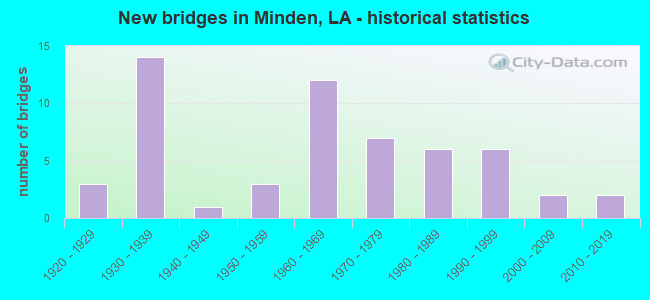
- New bridges - historical statistics
- 31920-1929
- 141930-1939
- 11940-1949
- 31950-1959
- 121960-1969
- 71970-1979
- 61980-1989
- 61990-1999
- 22000-2009
- 22010-2019

- Reconstructed bridges - Historical Statistics
- 61980-1989
- 21990-1999


- Bridge Condition - Deck
- 9.4%Very good
- 6.3%Good
- 40.6%Satisfactory
- 25.0%Fair
- 9.4%Poor
- 9.4%Serious

- Bridge Condition - Superstructure
- 9.4%Very good
- 21.9%Good
- 28.1%Satisfactory
- 28.1%Fair
- 6.3%Poor
- 6.3%Serious

- Bridge Condition - Substructure
- 6.3%Very good
- 6.3%Good
- 25.0%Satisfactory
- 31.3%Fair
- 18.8%Poor
- 12.5%Serious

- Bridge Condition - Channel
- 6.3%Very good
- 16.7%Good
- 35.4%Satisfactory
- 33.3%Fair
- 8.3%Poor

- Bridge Condition - Culverts
- 33.3%Good
- 54.2%Satisfactory
- 12.5%Fair
Find on map >> Show street view
Structure Number: 46032352931801, Location: 0.3 MI W OF HWY 7 (Lat: 32.587769, Lng: -93.300611), Route carried "on" structure: County highway , Year Built: 1976, Status: Posted for load, Structure Length: 1.80m (5.91ft), Average Daily Traffic: 49 (year 2020), Average Future Daily Traffic: 24 (year 2036), Design Load: H 15, Features Intersected: MILE CREEK, Facility Carried by Structure: Tom Crichton Rd
Minimum Vertical Clearance: 30+ m (98+ ft), Kilometerpoint: 0.000, Lanes on structure: 1, Owner: County Highway Agency, Approaching Roadway Width: 10.4m (34.1ft), Material/Design: Wood or Timber, Design/Construction: Stringer/Multi-beam, Number Of Spans In Main Unit: 3, Length of Maximum Span: 5.8m (19.0ft), Curb-To-Curb Width: 6.4m (21.0ft), Out-to-Out Width: 6.7m (22.0ft)
Condition: Deck: Fair, Superstructure: Satisfactory, Substructure: Serious, Channel: Fair, Operating Rating: 25.4 metric tons, Method Used To Determine Operating Rating: Allowable Stress (AS), Inventory Rating: 18.1 metric tons, Method Used To Determine Inventory Rating: Allowable Stress (AS), Structural Evaluation: High priority of corrective action, Deck Geometry: Somewhat better than minimum adequacy, Waterway Adequacy: Equal to present desirable criteria, Approach Roadway Alignment: Equal to present desirable criteria, Bridge Posting: Required (Relationship of Operating Rating to Maximum Legal Load: 0.1 - 9.9% below), Designated Inspection Frequency: Every 24 months, Other Special Inspection Frequency: Every 12 months, Inspection Date: July 2021, Other Special Inspection Date: December 2021, Deck Structure Type: Wood or Timber
Find on map >> Show street view
Structure Number: 46032353931691, Location: 0.7 MI SE OF LA 7 (Lat: 32.589339, Lng: -93.281411), Route carried "on" structure: County highway , Year Built: 1995, Status: Open, Structure Length: 6.71m (22.01ft), Average Daily Traffic: 68 (year 2020), Average Future Daily Traffic: 75 (year 2040), Design Load: HS 20, Features Intersected: COOLEY CREEK, Facility Carried by Structure: Industrial Drive
Minimum Vertical Clearance: 30+ m (98+ ft), Kilometerpoint: 0.000, Lanes on structure: 2, Owner: City or Municipal Highway Agency, Approaching Roadway Width: 8.5m (27.9ft), Material/Design: Concrete, Design/Construction: Slab, Number Of Spans In Main Unit: 11, Length of Maximum Span: 6.1m (20.0ft), Curb-To-Curb Width: 8.6m (28.2ft), Out-to-Out Width: 9.4m (30.8ft)
Condition: Deck: Satisfactory, Superstructure: Satisfactory, Substructure: Satisfactory, Channel: Satisfactory, Operating Rating: 40.2 metric tons, Method Used To Determine Operating Rating: Load and Resistance Factor Rating (LRFR) rating reported by rating factor(RF) method using HL-93 loadings, Inventory Rating: 31.1 metric tons, Method Used To Determine Inventory Rating: Load and Resistance Factor Rating (LRFR) rating reported by rating factor(RF) method using HL-93 loadings, Structural Evaluation: Equal to present minimum criteria, Deck Geometry: Better than present minimum criteria, Waterway Adequacy: Equal to present desirable criteria, Approach Roadway Alignment: Equal to present desirable criteria, Designated Inspection Frequency: Every 24 months, Inspection Date: July 2021, Deck Structure Type: Concrete Cast-file-Place
Find on map >> Show street view
Structure Number: 46032354931701, Location: 0.56 MI SE OF LA 7 (Lat: 32.590369, Lng: -93.284189), Route carried "on" structure: County highway , Year Built: 1995, Status: Open, Structure Length: 1.04m (3.41ft), Average Daily Traffic: 68 (year 2020), Average Future Daily Traffic: 75 (year 2040), Design Load: HS 20, Features Intersected: TRIBUTARY TO COOLEY CREE, Facility Carried by Structure: Industrial Drive
Minimum Vertical Clearance: 30+ m (98+ ft), Kilometerpoint: 0.000, Lanes on structure: 2, Owner: City or Municipal Highway Agency, Approaching Roadway Width: 9.4m (30.8ft), Material/Design: Concrete, Design/Construction: Culvert, Number Of Spans In Main Unit: 4, Length of Maximum Span: 2.4m (7.9ft), Curb-To-Curb Width: 9.4m (30.8ft), Out-to-Out Width: 25.0m (82.0ft)
Condition: Channel: Satisfactory, Culverts: Satisfactory, Operating Rating: 42.1 metric tons, Method Used To Determine Operating Rating: Load and Resistance Factor Rating (LRFR) rating reported by rating factor(RF) method using HL-93 loadings, Inventory Rating: 32.4 metric tons, Method Used To Determine Inventory Rating: Load and Resistance Factor Rating (LRFR) rating reported by rating factor(RF) method using HL-93 loadings, Structural Evaluation: Equal to present minimum criteria, Deck Geometry: Better than present minimum criteria, Waterway Adequacy: Equal to present desirable criteria, Approach Roadway Alignment: Equal to present minimum criteria, Designated Inspection Frequency: Every 24 months, Inspection Date: July 2021, Deck Structure Type: Concrete Cast-file-Place
Find on map >> Show street view
Structure Number: 46032366931751, Location: 0.3 MI W OF HWY 79-8 (Lat: 32.609939, Lng: -93.294339), Route carried "on" structure: County highway , Year Built: 1930, Status: Open, Structure Length: 0.98m (3.22ft), Average Daily Traffic: 4,200 (year 2022), Average Future Daily Traffic: 4,620 (year 2042), Design Load: HS 20, Features Intersected: TRIBUTARY TO MILE CREEK, Facility Carried by Structure: West St
Minimum Vertical Clearance: 30+ m (98+ ft), Kilometerpoint: 0.000, Lanes on structure: 2, Owner: City or Municipal Highway Agency, Approaching Roadway Width: 9.1m (29.9ft), Skew: 3 degrees, Material/Design: Concrete, Design/Construction: Culvert, Number Of Spans In Main Unit: 2, Length of Maximum Span: 4.3m (14.1ft), Curb-To-Curb Width: 9.1m (29.9ft), Out-to-Out Width: 12.8m (42.0ft)
Condition: Channel: Satisfactory, Culverts: Satisfactory, Operating Rating: 31.1 metric tons, Method Used To Determine Operating Rating: Load and Resistance Factor Rating (LRFR) rating reported by rating factor(RF) method using HL-93 loadings, Inventory Rating: 24.0 metric tons, Method Used To Determine Inventory Rating: Load and Resistance Factor Rating (LRFR) rating reported by rating factor(RF) method using HL-93 loadings, Structural Evaluation: Equal to present minimum criteria, Deck Geometry: Meets minimum limits, Waterway Adequacy: Equal to present desirable criteria, Approach Roadway Alignment: Equal to present desirable criteria, Designated Inspection Frequency: Every 24 months, Inspection Date: July 2021, Deck Structure Type: Concrete Cast-file-Place
Find on map >> Show street view
Structure Number: 46032366931761, Location: 0.4 MI W OF HWY 79-8 (Lat: 32.609761, Lng: -93.293061), Route carried "on" structure: County highway , Year Built: 1930, Status: Open, Structure Length: 0.70m (2.30ft), Average Daily Traffic: 4,200 (year 2022), Average Future Daily Traffic: 4,620 (year 2042), Design Load: HS 20, Features Intersected: MILE CREEK, Facility Carried by Structure: West St
Minimum Vertical Clearance: 30+ m (98+ ft), Kilometerpoint: 0.000, Lanes on structure: 2, Owner: City or Municipal Highway Agency, Approaching Roadway Width: 9.1m (29.9ft), Material/Design: Concrete, Design/Construction: Culvert, Number Of Spans In Main Unit: 2, Length of Maximum Span: 3.0m (9.8ft), Curb-To-Curb Width: 9.1m (29.9ft), Out-to-Out Width: 12.8m (42.0ft)
Condition: Channel: Satisfactory, Culverts: Satisfactory, Operating Rating: 40.8 metric tons, Method Used To Determine Operating Rating: Allowable Stress (AS), Inventory Rating: 24.5 metric tons, Method Used To Determine Inventory Rating: Allowable Stress (AS), Structural Evaluation: Equal to present minimum criteria, Deck Geometry: Meets minimum limits, Waterway Adequacy: Equal to present desirable criteria, Approach Roadway Alignment: Equal to present desirable criteria, Designated Inspection Frequency: Every 24 months, Inspection Date: July 2021, Deck Structure Type: Concrete Cast-file-Place
Find on map >> Show street view
Structure Number: 46032369931751, Location: 0.5 MI N OF HWY 79-8 (Lat: 32.614750, Lng: -93.290939), Route carried "on" structure: County highway , Year Built: 1965, Status: Posted for load, Structure Length: 0.82m (2.69ft), Average Daily Traffic: 520 (year 2022), Average Future Daily Traffic: 572 (year 2042), Design Load: HS 20, Features Intersected: TRIBUTARY TO MILE CREEK, Facility Carried by Structure: Miller St
Minimum Vertical Clearance: 30+ m (98+ ft), Kilometerpoint: 0.000, Lanes on structure: 2, Owner: City or Municipal Highway Agency, Approaching Roadway Width: 8.8m (28.9ft), Skew: 1 degrees, Material/Design: Concrete, Design/Construction: Culvert, Number Of Spans In Main Unit: 3, Length of Maximum Span: 2.4m (7.9ft), Curb-To-Curb Width: 8.5m (27.9ft), Out-to-Out Width: 8.9m (29.2ft)
Condition: Channel: Poor, Culverts: Satisfactory, Operating Rating: 22.7 metric tons, Method Used To Determine Operating Rating: Load and Resistance Factor Rating (LRFR) rating reported by rating factor(RF) method using HL-93 loadings, Inventory Rating: 17.5 metric tons, Method Used To Determine Inventory Rating: Load and Resistance Factor Rating (LRFR) rating reported by rating factor(RF) method using HL-93 loadings, Structural Evaluation: Meets minimum limits, Deck Geometry: Somewhat better than minimum adequacy, Waterway Adequacy: Equal to present desirable criteria, Approach Roadway Alignment: Equal to present desirable criteria, Bridge Posting: Required (Relationship of Operating Rating to Maximum Legal Load: 10.0 - 19.9% below), Designated Inspection Frequency: Every 24 months, Inspection Date: July 2021, Deck Structure Type: Concrete Cast-file-Place
Find on map >> Show street view
Structure Number: 46032370931751, Location: 0.3 MI N OF HWY 79-8 (Lat: 32.617150, Lng: -93.291269), Route carried "on" structure: County highway , Year Built: 1935, Status: Open, Structure Length: 0.79m (2.59ft), Average Daily Traffic: 158 (year 2020), Average Future Daily Traffic: 174 (year 2040), Design Load: HS 20, Features Intersected: MILE CREEK, Facility Carried by Structure: Pine St
Minimum Vertical Clearance: 30+ m (98+ ft), Kilometerpoint: 0.000, Lanes on structure: 2, Owner: City or Municipal Highway Agency, Approaching Roadway Width: 8.2m (26.9ft), Material/Design: Concrete, Design/Construction: Culvert, Number Of Spans In Main Unit: 3, Length of Maximum Span: 2.7m (8.9ft), Curb-To-Curb Width: 8.2m (26.9ft), Out-to-Out Width: 15.3m (50.2ft)
Condition: Channel: Good, Culverts: Satisfactory, Operating Rating: 45.0 metric tons, Method Used To Determine Operating Rating: Load and Resistance Factor Rating (LRFR) rating reported by rating factor(RF) method using HL-93 loadings, Inventory Rating: 34.7 metric tons, Method Used To Determine Inventory Rating: Load and Resistance Factor Rating (LRFR) rating reported by rating factor(RF) method using HL-93 loadings, Structural Evaluation: Equal to present minimum criteria, Deck Geometry: Somewhat better than minimum adequacy, Waterway Adequacy: Equal to present desirable criteria, Approach Roadway Alignment: Equal to present desirable criteria, Length Of Structure Improvement: 1.40m (4.59ft), Designated Inspection Frequency: Every 24 months, Inspection Date: July 2021, Bridge Improvement Cost: $83,000, Total Project Cost: $124,000 ( Estimate for 2016), Deck Structure Type: Concrete Cast-file-Place
Find on map >> Show street view
Structure Number: 46032371931451, Location: 0.3 MI E OF HWY 79 (Lat: 32.629669, Lng: -93.243469), Route carried "on" structure: County highway , Year Built: 1930, Status: Posted for load, Structure Length: 1.01m (3.31ft), Average Daily Traffic: 1,041 (year 2020), Average Future Daily Traffic: 510 (year 2036), Design Load: HS 20, Features Intersected: TRIB TO COOLEY BRANCH, Facility Carried by Structure: Old Arcadia Rd
Minimum Vertical Clearance: 30+ m (98+ ft), Kilometerpoint: 0.000, Lanes on structure: 2, Owner: County Highway Agency, Approaching Roadway Width: 9.1m (29.9ft), Skew: 30 degrees, Material/Design: Concrete, Design/Construction: Culvert, Number Of Spans In Main Unit: 6, Length of Maximum Span: 1.5m (4.9ft)
Condition: Channel: Fair, Culverts: Satisfactory, Operating Rating: 40.2 metric tons, Method Used To Determine Operating Rating: Load and Resistance Factor Rating (LRFR) rating reported by rating factor(RF) method using HL-93 loadings, Inventory Rating: 31.1 metric tons, Method Used To Determine Inventory Rating: Load and Resistance Factor Rating (LRFR) rating reported by rating factor(RF) method using HL-93 loadings, Structural Evaluation: Equal to present minimum criteria, Waterway Adequacy: Equal to present desirable criteria, Approach Roadway Alignment: Equal to present minimum criteria, Designated Inspection Frequency: Every 24 months, Inspection Date: July 2021, Deck Structure Type: Concrete Cast-file-Place
Find on map >> Show street view
Structure Number: 46032371931741, Location: 1 MI N OF HWY 79-80 (Lat: 32.617889, Lng: -93.290961), Route carried "on" structure: County highway , Year Built: 1930, Status: Open, Structure Length: 0.64m (2.10ft), Average Daily Traffic: 400 (year 2022), Average Future Daily Traffic: 440 (year 2042), Design Load: HS 20, Features Intersected: TRIBUTARY TO MILE CREEK, Facility Carried by Structure: McIntyre St
Minimum Vertical Clearance: 30+ m (98+ ft), Kilometerpoint: 0.000, Lanes on structure: 2, Owner: City or Municipal Highway Agency, Approaching Roadway Width: 7.9m (25.9ft), Material/Design: Concrete, Design/Construction: Culvert, Number Of Spans In Main Unit: 2, Length of Maximum Span: 3.0m (9.8ft), Curb-To-Curb Width: 7.9m (25.9ft), Out-to-Out Width: 12.3m (40.4ft)
Condition: Channel: Fair, Culverts: Satisfactory, Operating Rating: 42.1 metric tons, Method Used To Determine Operating Rating: Load and Resistance Factor Rating (LRFR) rating reported by rating factor(RF) method using HL-93 loadings, Inventory Rating: 32.4 metric tons, Method Used To Determine Inventory Rating: Load and Resistance Factor Rating (LRFR) rating reported by rating factor(RF) method using HL-93 loadings, Structural Evaluation: Equal to present minimum criteria, Deck Geometry: Somewhat better than minimum adequacy, Waterway Adequacy: Equal to present desirable criteria, Approach Roadway Alignment: Better than present minimum criteria, Designated Inspection Frequency: Every 24 months, Inspection Date: July 2021, Deck Structure Type: Concrete Cast-file-Place
Find on map >> Show street view
Structure Number: 46032372931551, Location: 0.3 MILES SOUTH OF US 79 (Lat: 32.619469, Lng: -93.258781), Route carried "on" structure: County highway , Year Built: 1980, Status: Open, Structure Length: 1.74m (5.71ft), Average Daily Traffic: 92 (year 2020), Average Future Daily Traffic: 101 (year 2040), Design Load: HS 20, Features Intersected: COOLEY CREEK, Facility Carried by Structure: Southridge Drive
Minimum Vertical Clearance: 30+ m (98+ ft), Kilometerpoint: 0.000, Lanes on structure: 2, Owner: City or Municipal Highway Agency, Approaching Roadway Width: 7.6m (24.9ft), Material/Design: Concrete, Design/Construction: Slab, Number Of Spans In Main Unit: 3, Length of Maximum Span: 5.8m (19.0ft), Curb-To-Curb Width: 9.9m (32.5ft), Out-to-Out Width: 10.7m (35.1ft)
Condition: Deck: Satisfactory, Superstructure: Satisfactory, Substructure: Fair, Channel: Satisfactory, Operating Rating: 86.8 metric tons, Method Used To Determine Operating Rating: Load and Resistance Factor Rating (LRFR) rating reported by rating factor(RF) method using HL-93 loadings, Inventory Rating: 67.1 metric tons, Method Used To Determine Inventory Rating: Load and Resistance Factor Rating (LRFR) rating reported by rating factor(RF) method using HL-93 loadings, Structural Evaluation: Somewhat better than minimum adequacy, Deck Geometry: Superior to present desirable criteria, Waterway Adequacy: Better than present minimum criteria, Approach Roadway Alignment: Better than present minimum criteria, Length Of Structure Improvement: 2.50m (8.20ft), Designated Inspection Frequency: Every 24 months, Inspection Date: July 2021, Bridge Improvement Cost: $173,000, Total Project Cost: $259,000 ( Estimate for 2016), Deck Structure Type: Concrete Precast Panels, Wearing Surface/Protective System: Wearing Surface: Bituminous
Find on map >> Show street view
Structure Number: 46032377931421, Location: 0.7 MI E OF HWY 79 (Lat: 32.628700, Lng: -93.237281), Route carried "on" structure: County highway , Year Built: 2004, Status: Open, Structure Length: 2.44m (8.01ft), Average Daily Traffic: 543 (year 2020), Average Future Daily Traffic: 300 (year 2036), Design Load: HS 20, Features Intersected: TRIB. TO COOLEY BRANCH, Facility Carried by Structure: Old Arcadia Rd
Minimum Vertical Clearance: 30+ m (98+ ft), Kilometerpoint: 0.000, Lanes on structure: 2, Base Highway Network: Yes, Owner: County Highway Agency, Approaching Roadway Width: 8.2m (26.9ft), Material/Design: Concrete, Design/Construction: Slab, Number Of Spans In Main Unit: 4, Length of Maximum Span: 6.1m (20.0ft), Curb-To-Curb Width: 8.6m (28.2ft), Out-to-Out Width: 9.3m (30.5ft)
Condition: Deck: Very good, Superstructure: Very good, Substructure: Good, Channel: Very good, Operating Rating: 53.1 metric tons, Method Used To Determine Operating Rating: Load and Resistance Factor Rating (LRFR) rating reported by rating factor(RF) method using HL-93 loadings, Inventory Rating: 41.1 metric tons, Method Used To Determine Inventory Rating: Load and Resistance Factor Rating (LRFR) rating reported by rating factor(RF) method using HL-93 loadings, Structural Evaluation: Better than present minimum criteria, Deck Geometry: Somewhat better than minimum adequacy, Waterway Adequacy: Equal to present desirable criteria, Approach Roadway Alignment: Equal to present desirable criteria, Designated Inspection Frequency: Every 24 months, Inspection Date: July 2021, Deck Structure Type: Concrete Precast Panels
Find on map >> Show street view
Structure Number: 46032378931451, Location: 0.4 MI E OF HWY 79 (Lat: 32.629531, Lng: -93.242519), Route carried "on" structure: County highway , Year Built: 1930, Status: Posted for load, Structure Length: 1.07m (3.51ft), Average Daily Traffic: 1,041 (year 2020), Average Future Daily Traffic: 510 (year 2036), Design Load: HS 20, Features Intersected: TRIB TO COOLEY BRANCH, Facility Carried by Structure: Old Arcadia Rd
Minimum Vertical Clearance: 30+ m (98+ ft), Kilometerpoint: 0.000, Lanes on structure: 2, Owner: County Highway Agency, Approaching Roadway Width: 9.1m (29.9ft), Material/Design: Concrete, Design/Construction: Culvert, Number Of Spans In Main Unit: 6, Length of Maximum Span: 1.8m (5.9ft)
Condition: Channel: Fair, Culverts: Satisfactory, Operating Rating: 33.7 metric tons, Method Used To Determine Operating Rating: Load and Resistance Factor Rating (LRFR) rating reported by rating factor(RF) method using HL-93 loadings, Inventory Rating: 26.2 metric tons, Method Used To Determine Inventory Rating: Load and Resistance Factor Rating (LRFR) rating reported by rating factor(RF) method using HL-93 loadings, Structural Evaluation: Equal to present minimum criteria, Waterway Adequacy: Better than present minimum criteria, Approach Roadway Alignment: Equal to present desirable criteria, Designated Inspection Frequency: Every 24 months, Inspection Date: July 2021, Deck Structure Type: Concrete Cast-file-Place
Find on map >> Show street view
Structure Number: 46032403931451, Location: 2.5 MI. N. OF HWY 79 (Lat: 32.671269, Lng: -93.241600), Route carried "on" structure: County highway , Year Built: 2001, Status: Open, Structure Length: 0.70m (2.30ft), Average Daily Traffic: 198 (year 2020), Average Future Daily Traffic: 108 (year 2036), Design Load: HS 20, Features Intersected: SUGAR CREEK, Facility Carried by Structure: Sugar Creek Rd
Minimum Vertical Clearance: 30+ m (98+ ft), Kilometerpoint: 0.000, Lanes on structure: 2, Base Highway Network: Yes, Owner: County Highway Agency, Approaching Roadway Width: 7.0m (23.0ft), Material/Design: Concrete, Design/Construction: Culvert, Number Of Spans In Main Unit: 3, Length of Maximum Span: 2.1m (6.9ft), Curb-To-Curb Width: 6.9m (22.6ft), Out-to-Out Width: 13.7m (44.9ft)
Condition: Channel: Good, Culverts: Good, Operating Rating: 42.1 metric tons, Method Used To Determine Operating Rating: Load and Resistance Factor Rating (LRFR) rating reported by rating factor(RF) method using HL-93 loadings, Inventory Rating: 32.4 metric tons, Method Used To Determine Inventory Rating: Load and Resistance Factor Rating (LRFR) rating reported by rating factor(RF) method using HL-93 loadings, Structural Evaluation: Better than present minimum criteria, Deck Geometry: Meets minimum limits, Waterway Adequacy: Equal to present desirable criteria, Approach Roadway Alignment: Equal to present minimum criteria, Designated Inspection Frequency: Every 24 months, Inspection Date: July 2021, Deck Structure Type: Concrete Cast-file-Place
Find on map >> Show street view
Structure Number: 46032412931571, Location: 2.75 MI. E. OF LA. 1 (Lat: 32.687050, Lng: -93.261139), Route carried "on" structure: County highway , Year Built: 1979, Status: Posted for load, Structure Length: 1.22m (4.00ft), Average Daily Traffic: 159 (year 2020), Average Future Daily Traffic: 78 (year 2036), Design Load: H 20, Features Intersected: COOLEY BRANCH, Facility Carried by Structure: Dogwood Trail
Minimum Vertical Clearance: 10.67m (35.01ft), Kilometerpoint: 0.000, Lanes on structure: 2, Owner: County Highway Agency, Approaching Roadway Width: 7.9m (25.9ft), Material/Design: Wood or Timber, Design/Construction: Stringer/Multi-beam, Number Of Spans In Main Unit: 2, Length of Maximum Span: 6.1m (20.0ft), Curb-To-Curb Width: 7.6m (24.9ft), Out-to-Out Width: 8.0m (26.2ft)
Condition: Deck: Fair, Superstructure: Fair, Substructure: Poor, Channel: Satisfactory, Operating Rating: 31.7 metric tons, Method Used To Determine Operating Rating: Allowable Stress (AS), Inventory Rating: 22.7 metric tons, Method Used To Determine Inventory Rating: Allowable Stress (AS), Structural Evaluation: Meets minimum limits, Deck Geometry: Somewhat better than minimum adequacy, Waterway Adequacy: Equal to present desirable criteria, Approach Roadway Alignment: Equal to present desirable criteria, Length Of Structure Improvement: 1.89m (6.20ft), Designated Inspection Frequency: Every 24 months, Other Special Inspection Frequency: Every 12 months, Inspection Date: July 2021, Other Special Inspection Date: December 2021, Bridge Improvement Cost: $112,000, Total Project Cost: $168,000 ( Estimate for 2016), Deck Structure Type: Wood or Timber, Wearing Surface/Protective System: Wearing Surface: Other
Find on map >> Show street view
Structure Number: 46032413931971, Location: 6 MI N OF HWY 79-80 (Lat: 32.688831, Lng: -93.329100), Route carried "on" structure: County highway , Year Built: 1971, Status: Open, Structure Length: 1.74m (5.71ft), Average Daily Traffic: 833 (year 2020), Average Future Daily Traffic: 408 (year 2036), Design Load: HS 20, Features Intersected: COW BRANCH, Facility Carried by Structure: Dorcheat Rd
Minimum Vertical Clearance: 30+ m (98+ ft), Kilometerpoint: 0.000, Lanes on structure: 2, Owner: County Highway Agency, Approaching Roadway Width: 12.8m (42.0ft), Material/Design: Concrete, Design/Construction: Slab, Number Of Spans In Main Unit: 3, Length of Maximum Span: 5.8m (19.0ft), Curb-To-Curb Width: 8.7m (28.5ft), Out-to-Out Width: 9.5m (31.2ft)
Condition: Deck: Fair, Superstructure: Fair, Substructure: Poor, Channel: Satisfactory, Operating Rating: 88.5 metric tons, Method Used To Determine Operating Rating: Load and Resistance Factor Rating (LRFR) rating reported by rating factor(RF) method using HL-93 loadings, Inventory Rating: 68.4 metric tons, Method Used To Determine Inventory Rating: Load and Resistance Factor Rating (LRFR) rating reported by rating factor(RF) method using HL-93 loadings, Structural Evaluation: Meets minimum limits, Deck Geometry: Somewhat better than minimum adequacy, Waterway Adequacy: Equal to present desirable criteria, Approach Roadway Alignment: Somewhat better than minimum adequacy, Length Of Structure Improvement: 2.44m (8.01ft), Designated Inspection Frequency: Every 24 months, Other Special Inspection Frequency: Every 12 months, Inspection Date: July 2021, Other Special Inspection Date: December 2021, Bridge Improvement Cost: $148,000, Total Project Cost: $222,000 ( Estimate for 2016), Deck Structure Type: Concrete Precast Panels
Find on map >> Show street view
Structure Number: 80608000002801, Location: 2.0 MI. E. OF LA. 159 (Lat: 32.689847, Lng: -93.297400), Route carried "on" structure: Federal lands road 814.4, Year Built: 1979, Status: Open, Structure Length: 1.22m (4.00ft), Average Daily Traffic: 30 (year 1996), Average Future Daily Traffic: 45 (year 2042), Design Load: HS 20, Features Intersected: COW BRANCH, Facility Carried by Structure: FDR 814
Minimum Vertical Clearance: 30+ m (98+ ft), Kilometerpoint: 0.689, Lanes on structure: 1, Owner: U.S. Forest Service, Approaching Roadway Width: 5.2m (17.1ft), Material/Design: Prestressed concrete, Design/Construction: Channel Beam, Number Of Spans In Main Unit: 2, Length of Maximum Span: 6.1m (20.0ft), Curb or Sidewalk Widths: Left: 0.1m (0.3ft), Right: 0.1m (0.3ft), Curb-To-Curb Width: 4.7m (15.4ft), Out-to-Out Width: 5.1m (16.7ft)
Condition: Deck: Good, Superstructure: Good, Substructure: Good, Channel: Satisfactory, Operating Rating: 24.9 metric tons, Method Used To Determine Operating Rating: Load and Resistance Factor Rating (LRFR) rating reported by rating factor(RF) method using HL-93 loadings, Inventory Rating: 17.8 metric tons, Method Used To Determine Inventory Rating: Load and Resistance Factor Rating (LRFR) rating reported by rating factor(RF) method using HL-93 loadings, Structural Evaluation: Somewhat better than minimum adequacy, Deck Geometry: Better than present minimum criteria, Waterway Adequacy: Equal to present desirable criteria, Approach Roadway Alignment: Equal to present desirable criteria, Designated Inspection Frequency: Every 24 months, Inspection Date: October 2020, Deck Structure Type: Other, Wearing Surface/Protective System: Wearing Surface: Integral Concrete
Find on map >> Show street view
Structure Number: 46000270313111, Location: I20 East under LA 7 (Lat: 32.589539, Lng: -93.293800), Route carried "under" structure: Interstate 20, Structure Length: 0. m, Average Daily Traffic: 43,000 (year 2014), Features Intersected: I20 EB under LA 7 SB
Minimum Vertical Clearance: 5.24m (17.19ft), Kilometerpoint: 14.565, Lanes on structure: 2, Length of Maximum Span: 0.0m
Find on map >> Show street view
Structure Number: 46000270313111, Location: I20 WB under LA 7 NB (Lat: 32.589650, Lng: -93.293169), Route carried "under" structure: Interstate 20, Structure Length: 0. m, Average Daily Traffic: 43,000 (year 2014), Features Intersected: I20 WB under LA 7 NB
Minimum Vertical Clearance: 5.12m (16.80ft), Kilometerpoint: 11.397, Lanes on structure: 2, Length of Maximum Span: 0.0m
Find on map >> Show street view
Structure Number: 46000270313111, Location: I20 under LA 7 (Lat: 32.589331, Lng: -93.293439), Route carried "under" structure: Interstate 20, Structure Length: 0. m, Average Daily Traffic: 43,000 (year 2014), Features Intersected: On/Off Ramp to I20 EB
Minimum Vertical Clearance: 5.58m (18.31ft), Kilometerpoint: 0.126, Lanes on structure: 2, Length of Maximum Span: 0.0m
Find on map >> Show street view
Structure Number: 46000270313112, Location: I20 East under LA 7 (Lat: 32.589539, Lng: -93.293800), Route carried "under" structure: Ramp Interstate 20, Structure Length: 0. m, Average Daily Traffic: 43,000 (year 2014), Features Intersected: I20 East Ramp to LA 7 No
Minimum Vertical Clearance: 5.12m (16.80ft), Kilometerpoint: 14.561, Lanes on structure: 2, Length of Maximum Span: 0.0m
Find on map >> Show street view
Structure Number: 46000270313112, Location: I20 WB under LA 7 (Lat: 32.589650, Lng: -93.293169), Route carried "under" structure: Interstate 20, Structure Length: 0. m, Average Daily Traffic: 43,000 (year 2014), Features Intersected: LA 7 NB to I20 WB
Minimum Vertical Clearance: 5.06m (16.60ft), Kilometerpoint: 11.397, Lanes on structure: 2, Length of Maximum Span: 0.0m
Find on map >> Show street view
Structure Number: 46000270313112, Location: I20 under LA 7 (Lat: 32.589411, Lng: -93.293839), Route carried "under" structure: Interstate 20, Structure Length: 0. m, Average Daily Traffic: 43,000 (year 2014), Features Intersected: On/Off Ramp to I20 EB
Minimum Vertical Clearance: 5.33m (17.49ft), Kilometerpoint: 0.087, Lanes on structure: 2, Length of Maximum Span: 0.0m
Find on map >> Show street view
Structure Number: 46001110203321, Location: I20 East under LA 531 SB (Lat: 32.580569, Lng: -93.247919), Route carried "under" structure: Interstate 20, Structure Length: 0. m, Average Daily Traffic: 29,000 (year 2016), Features Intersected: I20 East at LA 531
Minimum Vertical Clearance: 5.09m (16.70ft), Kilometerpoint: 18.982, Lanes on structure: 2, Length of Maximum Span: 0.0m
Find on map >> Show street view
Structure Number: 46001110203321, Location: I20 West under LA 531 NB (Lat: 32.580619, Lng: -93.247931), Route carried "under" structure: Interstate 20, Structure Length: 0. m, Average Daily Traffic: 29,000 (year 2016), Features Intersected: I20 West at LA 531
Minimum Vertical Clearance: 5.03m (16.50ft), Kilometerpoint: 7.033, Lanes on structure: 2, Length of Maximum Span: 0.0m