Bridge Statistics for Monroe, Louisiana (LA)
Condition, Traffic, Stress, Structural Evaluation, Project Costs
- National Bridge Inventory (NBI) Statistics
- 170Number of bridges
- 2,920ft / 890mTotal length
- $53,619,000Total costs
- 2,302,109Total average daily traffic
- 216,112Total average daily truck traffic
- National Bridge Inventory (NBI) Registered Bridges for Monroe
- No street view available for this location
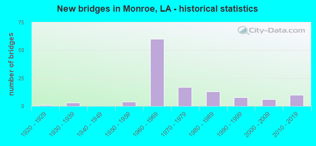
- New bridges - historical statistics
- 11920-1929
- 31930-1939
- 41950-1959
- 601960-1969
- 171970-1979
- 131980-1989
- 81990-1999
- 62000-2009
- 102010-2019


- Bridge Condition - Deck
- 2.9%Very good
- 20.6%Good
- 63.7%Satisfactory
- 6.9%Fair
- 3.9%Poor
- 2.0%Serious
- 1.0%Failed

- Bridge Condition - Superstructure
- 2.9%Very good
- 29.4%Good
- 58.8%Satisfactory
- 6.9%Fair
- 2.0%Poor
- 1.0%Failed

- Bridge Condition - Substructure
- 5.9%Very good
- 30.4%Good
- 51.0%Satisfactory
- 4.9%Fair
- 4.9%Poor
- 2.0%Imminent failure
- 1.0%Failed

- Bridge Condition - Channel
- 10.0%Very good
- 8.9%Good
- 70.0%Satisfactory
- 1.1%Fair
- 8.9%Poor
- 1.1%Failed

- Bridge Condition - Culverts
- 10.0%Very good
- 35.0%Good
- 55.0%Satisfactory
Find on map >> Show street view
Structure Number: 53732350920401, Location: BAYOU DESIARD (Lat: 32.582539, Lng: -92.071081), Route carried "on" structure: County highway , Year Built: 1990, Status: Open, Structure Length: 1.74m (5.71ft), Average Daily Traffic: 1,616 (year 1986), Average Future Daily Traffic: 969 (year 2036), Design Load: HS 20, Features Intersected: BAYOU DESIARD, Facility Carried by Structure: FORTUNE DR
Minimum Vertical Clearance: 30+ m (98+ ft), Kilometerpoint: 0.000, Lanes on structure: 2, Owner: County Highway Agency, Approaching Roadway Width: 8.2m (26.9ft), Material/Design: Concrete, Design/Construction: Slab, Number Of Spans In Main Unit: 3, Length of Maximum Span: 5.8m (19.0ft), Curb-To-Curb Width: 9.8m (32.2ft), Out-to-Out Width: 10.6m (34.8ft)
Condition: Deck: Satisfactory, Superstructure: Satisfactory, Substructure: Very good, Channel: Satisfactory, Operating Rating: 43.1 metric tons, Method Used To Determine Operating Rating: Load and Resistance Factor Rating (LRFR) rating reported by rating factor(RF) method using HL-93 loadings, Inventory Rating: 33.4 metric tons, Method Used To Determine Inventory Rating: Load and Resistance Factor Rating (LRFR) rating reported by rating factor(RF) method using HL-93 loadings, Structural Evaluation: Equal to present minimum criteria, Deck Geometry: Somewhat better than minimum adequacy, Waterway Adequacy: Better than present minimum criteria, Approach Roadway Alignment: Equal to present desirable criteria, Designated Inspection Frequency: Every 24 months, Inspection Date: March 2020, Deck Structure Type: Concrete Precast Panels
Find on map >> Show street view
Structure Number: 53732354920381, Location: AT LA FISH HATCHERY (Lat: 32.590069, Lng: -92.063589), Route carried "on" structure: County highway , Year Built: 1975, Status: Open, Structure Length: 1.52m (4.99ft), Average Daily Traffic: 265 (year 1979), Average Future Daily Traffic: 159 (year 2036), Design Load: HS 20, Features Intersected: DESIARD BAYOU, Facility Carried by Structure: CENTURY LINK DR
Minimum Vertical Clearance: 30+ m (98+ ft), Kilometerpoint: 0.000, Lanes on structure: 2, Owner: City or Municipal Highway Agency, Approaching Roadway Width: 10.4m (34.1ft), Material/Design: Prestressed concrete, Design/Construction: Channel Beam, Number Of Spans In Main Unit: 2, Length of Maximum Span: 7.6m (24.9ft), Curb or Sidewalk Widths: Left: 0.0m, Right: 0.8m (2.6ft), Curb-To-Curb Width: 9.1m (29.9ft), Out-to-Out Width: 10.8m (35.4ft)
Condition: Deck: Satisfactory, Superstructure: Satisfactory, Substructure: Satisfactory, Channel: Poor, Operating Rating: 39.5 metric tons, Method Used To Determine Operating Rating: Load and Resistance Factor Rating (LRFR) rating reported by rating factor(RF) method using HL-93 loadings, Inventory Rating: 30.5 metric tons, Method Used To Determine Inventory Rating: Load and Resistance Factor Rating (LRFR) rating reported by rating factor(RF) method using HL-93 loadings, Structural Evaluation: Equal to present minimum criteria, Deck Geometry: Equal to present minimum criteria, Waterway Adequacy: Better than present minimum criteria, Approach Roadway Alignment: Equal to present desirable criteria, Designated Inspection Frequency: Every 24 months, Inspection Date: July 2020, Deck Structure Type: Concrete Precast Panels, Wearing Surface/Protective System: Wearing Surface: Bituminous
Find on map >> Show street view
Structure Number: 53732457914901, Location: 1.0 MI SOUTH LA 34 (Lat: 32.476481, Lng: -92.134919), Route carried "on" structure: County highway , Year Built: 1987, Status: Open, Structure Length: 10.39m (34.09ft), Average Daily Traffic: 130 (year 1979), Average Future Daily Traffic: 78 (year 2036), Design Load: HS 20, Features Intersected: TONEY BAYOU, Facility Carried by Structure: TONEY BAYOU RD
Minimum Vertical Clearance: 30+ m (98+ ft), Kilometerpoint: 0.000, Lanes on structure: 2, Owner: County Highway Agency, Approaching Roadway Width: 7.9m (25.9ft), Material/Design: Concrete, Design/Construction: Slab, Number Of Spans In Main Unit: 18, Length of Maximum Span: 5.8m (19.0ft), Curb-To-Curb Width: 8.5m (27.9ft), Out-to-Out Width: 9.4m (30.8ft)
Condition: Deck: Satisfactory, Superstructure: Satisfactory, Substructure: Satisfactory, Channel: Satisfactory, Operating Rating: 53.8 metric tons, Method Used To Determine Operating Rating: Load and Resistance Factor Rating (LRFR) rating reported by rating factor(RF) method using HL-93 loadings, Inventory Rating: 41.5 metric tons, Method Used To Determine Inventory Rating: Load and Resistance Factor Rating (LRFR) rating reported by rating factor(RF) method using HL-93 loadings, Structural Evaluation: Equal to present minimum criteria, Deck Geometry: Equal to present minimum criteria, Waterway Adequacy: Better than present minimum criteria, Approach Roadway Alignment: Equal to present minimum criteria, Designated Inspection Frequency: Every 24 months, Underwater Inspection Frequency: Every 60 months, Inspection Date: April 2020, Underwater Inspection Date: June 2018, Deck Structure Type: Concrete Precast Panels, Wearing Surface/Protective System: Wearing Surface: Bituminous
Find on map >> Show street view
Structure Number: 53700153100281, Location: 0.3 MI FROM US 165 (Lat: 32.415831, Lng: -92.101489), Route carried "under" structure: US 165, Structure Length: 0. m, Average Daily Traffic: 760 (year 2016), Features Intersected: US 165 BR UNDER US 165 N
Minimum Vertical Clearance: 7.32m (24.02ft), Kilometerpoint: 16.576, Lanes on structure: 2, Lanes under structure: 1, Length of Maximum Span: 0.0m
Find on map >> Show street view
Structure Number: 53700153106361, Location: 0.2 MI N OF I-20 (Lat: 32.502650, Lng: -92.082400), Route carried "under" structure: US 165, Structure Length: 0. m, Average Daily Traffic: 27,480 (year 2015), Features Intersected: 165 NB OVER 165 BY PASS
Minimum Vertical Clearance: 7.86m (25.79ft), Kilometerpoint: 0.023, Lanes on structure: 2, Length of Maximum Span: 0.0m
Find on map >> Show street view
Structure Number: 53700153106361, Location: 0.2 MI N OF I-20 (Lat: 32.501081, Lng: -92.082550), Route carried "under" structure: US 165, Structure Length: 0. m, Average Daily Traffic: 27,480 (year 2015), Features Intersected: 165 N OVER 165 N OFF RAM
Minimum Vertical Clearance: 4.63m (15.19ft), Kilometerpoint: 0.402, Lanes on structure: 2, Length of Maximum Span: 0.0m
Find on map >> Show street view
Structure Number: 53700153106361, Location: 0.2 MI N OF I-20 (Lat: 32.502061, Lng: -92.082461), Route carried "under" structure: US 165, Structure Length: 0. m, Average Daily Traffic: 27,480 (year 2015), Features Intersected: 165 NB OVER LA 594
Minimum Vertical Clearance: 7.68m (25.20ft), Kilometerpoint: 2.863, Lanes on structure: 3, Length of Maximum Span: 0.0m
Find on map >> Show street view
Structure Number: 53700153106362, Location: 0.2 MI N OF I-20 (Lat: 32.501269, Lng: -92.082819), Route carried "under" structure: US 165, Structure Length: 0. m, Average Daily Traffic: 27,480 (year 2015), Features Intersected: 165 SB OVER 165 ON RAMP
Minimum Vertical Clearance: 4.91m (16.11ft), Kilometerpoint: 2.354, Length of Maximum Span: 0.0m
Find on map >> Show street view
Structure Number: 53700153106362, Location: 0.2 MI N OF I-20 (Lat: 32.502081, Lng: -92.082931), Route carried "under" structure: US 165, Structure Length: 0. m, Average Daily Traffic: 27,480 (year 2015), Features Intersected: 165 SB OVER LA 594
Minimum Vertical Clearance: 7.47m (24.51ft), Kilometerpoint: 2.820, Lanes on structure: 3, Length of Maximum Span: 0.0m
Find on map >> Show street view
Structure Number: 53700153106362, Location: 0.2 MI N OF I-20 (Lat: 32.502681, Lng: -92.082839), Route carried "under" structure: US 165, Structure Length: 0. m, Average Daily Traffic: 27,480 (year 2015), Features Intersected: 165 SB OVER US 165 BYPAS
Minimum Vertical Clearance: 7.89m (25.89ft), Kilometerpoint: 1.901, Length of Maximum Span: 0.0m
Find on map >> Show street view
Structure Number: 53700153106368, Location: 0.2 MI N OF I-20 (Lat: 32.501400, Lng: -92.083169), Route carried "under" structure: Ramp US 165, Structure Length: 0. m, Average Daily Traffic: 8,060 (year 2015), Features Intersected: 165 S OFF RAMP TO I-20
Minimum Vertical Clearance: 4.91m (16.11ft), Kilometerpoint: 0.470, Lanes on structure: 2, Length of Maximum Span: 0.0m
Find on map >> Show street view
Structure Number: 53700160100001, Location: 0.01 MI W OF US 165 O.R (Lat: 32.522569, Lng: -92.080731), Route carried "under" structure: ServiceUS 165, Structure Length: 0. m, Average Daily Traffic: 4,500 (year 2016), Features Intersected: US 165 TURN AROUND UNDER
Minimum Vertical Clearance: 4.94m (16.21ft), Kilometerpoint: 0.069, Lanes on structure: 4, Lanes under structure: 1, Length of Maximum Span: 0.0m
Find on map >> Show street view
Structure Number: 53700160100001, Location: 0.01 MI E OF S SERVICE RD (Lat: 32.522789, Lng: -92.080731), Route carried "under" structure: US 165, Structure Length: 0. m, Average Daily Traffic: 4,500 (year 2016), Features Intersected: US 165 U TURN UNDER US 1
Minimum Vertical Clearance: 4.91m (16.11ft), Kilometerpoint: 0.056, Lanes on structure: 4, Lanes under structure: 1, Length of Maximum Span: 0.0m
Find on map >> Show street view
Structure Number: 53700160100001, Location: 2.84 MI W OF LA 139 (Lat: 32.522569, Lng: -92.080731), Route carried "under" structure: US 80, Structure Length: 0. m, Average Daily Traffic: 12,950 (year 2016), Features Intersected: US 80 WB UNDER US 165
Minimum Vertical Clearance: 5.09m (16.70ft), Kilometerpoint: 16.423, Lanes on structure: 4, Lanes under structure: 2, Length of Maximum Span: 0.0m
Find on map >> Show street view
Structure Number: 53700160100001, Location: 0.5 MI E OF LA 3275 (Lat: 32.522569, Lng: -92.080731), Route carried "under" structure: ServiceUS 165, Structure Length: 0. m, Average Daily Traffic: 12,950 (year 2016), Features Intersected: US 80 EB UNDER US 165, Facility Carried by Structure: US 80
Minimum Vertical Clearance: 5.12m (16.80ft), Kilometerpoint: 0.211, Lanes on structure: 4, Lanes under structure: 2, Length of Maximum Span: 0.0m
Find on map >> Show street view
Structure Number: 53703260100711, Location: 0.9 MI W OF US 165 (Lat: 32.500381, Lng: -92.100019), Route carried "under" structure: ServiceInterstate 20, Structure Length: 0. m, Average Daily Traffic: 8,720 (year 2017), Features Intersected: I-20 EB SERVICE RD UNDER
Minimum Vertical Clearance: 5.24m (17.19ft), Kilometerpoint: 0.269, Lanes on structure: 3, Lanes under structure: 2, Length of Maximum Span: 0.0m
Find on map >> Show street view
Structure Number: 53703260100711, Location: 0.9 MI W OF US 165 (Lat: 32.500531, Lng: -92.099781), Route carried "under" structure: Interstate 20, Structure Length: 0. m, Average Daily Traffic: 43,600 (year 2017), Features Intersected: I-20 EB UNDER LA 594 (TE
Minimum Vertical Clearance: 5.49m (18.01ft), Kilometerpoint: 30.447, Lanes on structure: 3, Lanes under structure: 3, Length of Maximum Span: 0.0m
Find on map >> Show street view
Structure Number: 53703260100711, Location: 0.9 MI W OF US 165 (Lat: 32.500650, Lng: -92.099331), Route carried "under" structure: Interstate 20, Structure Length: 0. m, Average Daily Traffic: 43,600 (year 2017), Features Intersected: I-20 WB UNDER LA 594 (TE
Minimum Vertical Clearance: 5.46m (17.91ft), Kilometerpoint: 15.630, Lanes on structure: 3, Lanes under structure: 3, Length of Maximum Span: 0.0m
Find on map >> Show street view
Structure Number: 53703260100711, Location: 0.9 MI W OF US 165 (Lat: 32.500819, Lng: -92.099069), Route carried "under" structure: ServiceInterstate 20, Structure Length: 0. m, Average Daily Traffic: 8,720 (year 2017), Features Intersected: I-20 WB SERVICE RD UNDER
Minimum Vertical Clearance: 5.27m (17.29ft), Kilometerpoint: 0.251, Lanes on structure: 3, Lanes under structure: 2, Length of Maximum Span: 0.0m
Find on map >> Show street view
Structure Number: 53704510616841, Location: .353 MI E OF LA 15 (Lat: 32.497100, Lng: -92.113461), Route carried "under" structure: Ramp Interstate 20, Structure Length: 0. m, Average Daily Traffic: 8,930 (year 2017), Features Intersected: I-20 EB OFF RAMP TO JACK
Minimum Vertical Clearance: 6.28m (20.60ft), Kilometerpoint: 0.177, Lanes on structure: 2, Lanes under structure: 1, Length of Maximum Span: 0.0m
Find on map >> Show street view
Structure Number: 53704510616841, Location: 0.26 MI E OF LA 15 (Lat: 32.497811, Lng: -92.112319), Route carried "under" structure: Ramp Interstate 20, Structure Length: 0. m, Average Daily Traffic: 8,930 (year 2017), Features Intersected: I-20 WB OFF RAMP TO LAYT
Minimum Vertical Clearance: 6.58m (21.59ft), Kilometerpoint: 0.270, Lanes on structure: 2, Lanes under structure: 1, Length of Maximum Span: 0.0m
Find on map >> Show street view
Structure Number: 53704510616841, Location: 0.20 MI E OF LA 15 (Lat: 32.498419, Lng: -92.111461), Route carried "under" structure: Ramp Interstate 20, Structure Length: 0. m, Average Daily Traffic: 8,930 (year 2017), Features Intersected: I-20 EB OFF RAMP TO HALL
Minimum Vertical Clearance: 6.43m (21.10ft), Kilometerpoint: 0.283, Lanes on structure: 2, Lanes under structure: 1, Length of Maximum Span: 0.0m
Find on map >> Show street view
Structure Number: 53704510616841, Location: 1.5 MI W OF US 165 (Lat: 32.500211, Lng: -92.108581), Route carried "under" structure: State highway 15, Structure Length: 0. m, Average Daily Traffic: 4,400 (year 2017), Features Intersected: LA 15 SB UNDER I-20 EB
Minimum Vertical Clearance: 5.88m (19.29ft), Kilometerpoint: 1.442, Lanes on structure: 2, Lanes under structure: 3, Length of Maximum Span: 0.0m
Find on map >> Show street view
Structure Number: 53704510616841, Location: 1.5 MI W OF US 165 (Lat: 32.500289, Lng: -92.108431), Route carried "under" structure: State highway 15, Structure Length: 0. m, Average Daily Traffic: 4,400 (year 2017), Features Intersected: LA 15 UNDER I-20 EB
Minimum Vertical Clearance: 6.07m (19.91ft), Kilometerpoint: 26.319, Lanes on structure: 2, Lanes under structure: 2, Length of Maximum Span: 0.0m
Find on map >> Show street view
Structure Number: 53704510616842, Location: 1.5 MI W OF US 165 (Lat: 32.500411, Lng: -92.108731), Route carried "under" structure: State highway 15, Structure Length: 0. m, Average Daily Traffic: 4,400 (year 2017), Features Intersected: LA 15 SB UNDER I-20 WB
Minimum Vertical Clearance: 6.61m (21.69ft), Kilometerpoint: 1.440, Lanes on structure: 2, Lanes under structure: 3, Length of Maximum Span: 0.0m
Find on map >> Show street view
Structure Number: 53704510616842, Location: 1.5 MI OF US 165 (Lat: 32.500469, Lng: -92.108581), Route carried "under" structure: State highway 15, Structure Length: 0. m, Average Daily Traffic: 4,400 (year 2017), Features Intersected: LA 15 NB UNDER I-20 WB
Minimum Vertical Clearance: 6.77m (22.21ft), Kilometerpoint: 26.319, Lanes on structure: 2, Lanes under structure: 2, Length of Maximum Span: 0.0m
Find on map >> Show street view
Structure Number: 53704510616842, Location: 0.353 MI E OF LA 15 (Lat: 32.497219, Lng: -92.113519), Route carried "under" structure: Ramp Interstate 20, Structure Length: 0. m, Average Daily Traffic: 8,930 (year 2017), Features Intersected: I-20 EB OFF RAMP TO JACK
Minimum Vertical Clearance: 5.91m (19.39ft), Kilometerpoint: 0.177, Lanes on structure: 2, Lanes under structure: 1, Length of Maximum Span: 0.0m
Find on map >> Show street view
Structure Number: 53704510616842, Location: 0.26 MI E OF LA 15 (Lat: 32.498119, Lng: -92.112281), Route carried "under" structure: Ramp Interstate 20, Structure Length: 0. m, Average Daily Traffic: 8,930 (year 2017), Features Intersected: I-20 WB OFF RAMP TO LAYT
Minimum Vertical Clearance: 5.94m (19.49ft), Kilometerpoint: 0.270, Lanes on structure: 2, Lanes under structure: 1, Length of Maximum Span: 0.0m
Find on map >> Show street view
Structure Number: 53704510616842, Location: 0.20 MI E LA 15 (Lat: 32.498650, Lng: -92.111450), Route carried "under" structure: Ramp Interstate 20, Structure Length: 0. m, Average Daily Traffic: 8,930 (year 2017), Features Intersected: I-20 EB OFF RAMP UNDER I
Minimum Vertical Clearance: 6.61m (21.69ft), Kilometerpoint: 0.309, Lanes on structure: 2, Lanes under structure: 1, Length of Maximum Span: 0.0m
Find on map >> Show street view
Structure Number: 53704510617947, Location: 0.05 MI E OF I 10 (Lat: 32.497019, Lng: -92.113481), Route carried "under" structure: Ramp Interstate 20, Structure Length: 0. m, Average Daily Traffic: 8,760 (year 2016), Features Intersected: I 20 EB OFF RAMP TO JACK
Minimum Vertical Clearance: 4.72m (15.49ft), Kilometerpoint: 0.093, Lanes on structure: 1, Lanes under structure: 1, Length of Maximum Span: 0.0m
Find on map >> Show street view
Structure Number: 53704510617986, Location: 0.062 MI E OF I 20 (Lat: 32.497350, Lng: -92.113611), Route carried "under" structure: Ramp Interstate 20, Structure Length: 0. m, Average Daily Traffic: 8,760 (year 2016), Features Intersected: I 20 ON RAMP EB FROM JAC
Minimum Vertical Clearance: 4.66m (15.29ft), Kilometerpoint: 0.034, Lanes on structure: 1, Lanes under structure: 1, Length of Maximum Span: 0.0m
Find on map >> Show street view
Structure Number: 53704510618067, Location: 0.12 MI FROM I 20 (Lat: 32.498111, Lng: -92.112319), Route carried "under" structure: Ramp Interstate 20, Structure Length: 0. m, Average Daily Traffic: 8,760 (year 2016), Features Intersected: I 20 WB OFF RAMP TO S 2N
Minimum Vertical Clearance: 4.82m (15.81ft), Kilometerpoint: 0.299, Lanes on structure: 1, Lanes under structure: 1, Length of Maximum Span: 0.0m
Find on map >> Show street view
Structure Number: 53704510618067, Location: 0.12 MI FROM I 20 (Lat: 32.497919, Lng: -92.112239), Route carried "under" structure: Ramp Interstate 20, Structure Length: 0. m, Average Daily Traffic: 8,760 (year 2016), Features Intersected: I 20 WB OFF RAMP TO LAYT
Minimum Vertical Clearance: 4.63m (15.19ft), Kilometerpoint: 0.016, Lanes on structure: 1, Lanes under structure: 1, Length of Maximum Span: 0.0m
Find on map >> Show street view
Structure Number: 53704510618096, Location: 0.1 MI N OF I 20 (Lat: 32.498961, Lng: -92.111550), Route carried "under" structure: Ramp Interstate 20, Structure Length: 0. m, Average Daily Traffic: 8,760 (year 2016), Features Intersected: I 20 EB OFF RAMP TO HALL
Minimum Vertical Clearance: 4.72m (15.49ft), Kilometerpoint: 0.344, Lanes on structure: 1, Lanes under structure: 1, Length of Maximum Span: 0.0m
Find on map >> Show street view
Structure Number: 53704510618228, Location: 0.01 MI N OF I 20 (Lat: 32.498661, Lng: -92.111461), Route carried "under" structure: Ramp Interstate 20, Structure Length: 0. m, Average Daily Traffic: 8,760 (year 2016), Features Intersected: I 20 EB OFF RAMP TO HALL
Minimum Vertical Clearance: 4.57m (14.99ft), Kilometerpoint: 0.311, Lanes on structure: 1, Lanes under structure: 1, Length of Maximum Span: 0.0m
Find on map >> Show street view
Structure Number: 53704510619351, Location: .5 MI W OF US 165 (Lat: 32.500169, Lng: -92.092031), Route carried "under" structure: Interstate 20, Structure Length: 0. m, Average Daily Traffic: 40,300 (year 2015), Features Intersected: ORANGE STREET OVER I-20
Minimum Vertical Clearance: 4.88m (16.01ft), Kilometerpoint: 14.943, Lanes on structure: 2, Lanes under structure: 3, Length of Maximum Span: 0.0m
Find on map >> Show street view
Structure Number: 53704510619351, Location: .5 MI W OF US 165 (Lat: 32.499939, Lng: -92.092619), Route carried "under" structure: Interstate 20, Structure Length: 0. m, Average Daily Traffic: 40,300 (year 2015), Features Intersected: ORANGE STREET OVER I-20
Minimum Vertical Clearance: 4.94m (16.21ft), Kilometerpoint: 31.121, Lanes on structure: 2, Lanes under structure: 3, Length of Maximum Span: 0.0m
Find on map >> Show street view
Structure Number: 53704510619881, Location: 0.9 MI E OF TEXAS AVE (Lat: 32.499089, Lng: -92.082419), Route carried "under" structure: US 165, Structure Length: 0. m, Average Daily Traffic: 44,400 (year 2015), Features Intersected: I-20 EB OVER 165 NB, Facility Carried by Structure: I-20 EB
Minimum Vertical Clearance: 5.21m (17.09ft), Kilometerpoint: 10.186, Lanes on structure: 2, Length of Maximum Span: 0.0m
Find on map >> Show street view
Structure Number: 53704510619881, Location: 0.9 MI E OF TEXAS AVE (Lat: 32.499061, Lng: -92.081950), Route carried "under" structure: Ramp US 165, Structure Length: 0. m, Average Daily Traffic: 44,400 (year 2015), Features Intersected: I-20 EB OVER 165 N OFF R, Facility Carried by Structure: I-20 EB
Minimum Vertical Clearance: 4.91m (16.11ft), Kilometerpoint: 0.163, Lanes on structure: 2, Length of Maximum Span: 0.0m
Find on map >> Show street view
Structure Number: 53704510619881, Location: 0.9 MI E OF TEXAS AVE (Lat: 32.499289, Lng: -92.083100), Route carried "under" structure: US 165, Structure Length: 0. m, Average Daily Traffic: 44,400 (year 2015), Features Intersected: I-20 EB OVER US 165 SB, Facility Carried by Structure: I-20 EB
Minimum Vertical Clearance: 4.85m (15.91ft), Kilometerpoint: 2.575, Lanes on structure: 3, Length of Maximum Span: 0.0m
Find on map >> Show street view
Structure Number: 53704510619882, Location: 0.9 MI E OF TEXAS AVE (Lat: 32.499339, Lng: -92.081919), Route carried "under" structure: Ramp US 165, Structure Length: 0. m, Average Daily Traffic: 48,360 (year 2015), Features Intersected: 165 NB OFF RAMP UNDER I-, Facility Carried by Structure: I-20 WB
Minimum Vertical Clearance: 5.03m (16.50ft), Kilometerpoint: 0.195, Lanes on structure: 2, Length of Maximum Span: 0.0m
Find on map >> Show street view
Structure Number: 53704510619882, Location: 0.9 MI E OF TEXAS AVE (Lat: 32.499531, Lng: -92.083061), Route carried "under" structure: US 165, Structure Length: 0. m, Average Daily Traffic: 48,360 (year 2015), Features Intersected: 165 SB UNDER I-20 WB, Facility Carried by Structure: I-20 WB
Minimum Vertical Clearance: 4.88m (16.01ft), Kilometerpoint: 2.548, Lanes on structure: 3, Length of Maximum Span: 0.0m
Find on map >> Show street view
Structure Number: 53704510619882, Location: 0.9 MI E OF TEXAS AVE (Lat: 32.499381, Lng: -92.082431), Route carried "under" structure: US 165, Structure Length: 0. m, Average Daily Traffic: 48,360 (year 2015), Features Intersected: 165 NB UNDER I-20 WB, Facility Carried by Structure: I-20 WB
Minimum Vertical Clearance: 5.27m (17.29ft), Kilometerpoint: 10.218, Lanes on structure: 3, Length of Maximum Span: 0.0m
Find on map >> Show street view
Structure Number: 53704510619887, Location: 0.1 MI S OF I-20 (Lat: 32.497500, Lng: -92.083261), Route carried "under" structure: Interstate 20, Structure Length: 0. m, Average Daily Traffic: 8,060 (year 2015), Features Intersected: FLY RAMP OVER 165 S TO 1
Minimum Vertical Clearance: 4.72m (15.49ft), Kilometerpoint: 2.784, Lanes on structure: 2, Length of Maximum Span: 0.0m
Find on map >> Show street view
Structure Number: 53704510620321, Location: 0.4 MI E OF US 165 (Lat: 32.498669, Lng: -92.075550), Route carried "under" structure: Interstate 20, Structure Length: 0. m, Average Daily Traffic: 7,400 (year 2015), Features Intersected: NUTLAND RD OVER I-20
Minimum Vertical Clearance: 5.00m (16.40ft), Kilometerpoint: 13.383, Lanes on structure: 2, Lanes under structure: 2, Length of Maximum Span: 0.0m
Find on map >> Show street view
Structure Number: 53704510620321, Location: 0.4 MI E OF US 165 (Lat: 32.498431, Lng: -92.075661), Route carried "under" structure: Interstate 20, Structure Length: 0. m, Average Daily Traffic: 7,400 (year 2015), Features Intersected: NUTLAND RD OVER I-20
Minimum Vertical Clearance: 4.97m (16.31ft), Kilometerpoint: 32.726, Lanes on structure: 2, Lanes under structure: 2, Length of Maximum Span: 0.0m
Find on map >> Show street view
Structure Number: 53704510621417, Location: 1.5 MI E OF US 165 (Lat: 32.494769, Lng: -92.056519), Route carried "under" structure: Interstate 20, Structure Length: 0. m, Average Daily Traffic: 7,400 (year 2015), Features Intersected: MALL FLY RAMP OVER I-20
Minimum Vertical Clearance: 6.40m (21.00ft), Kilometerpoint: 11.542, Lanes on structure: 2, Length of Maximum Span: 0.0m
Find on map >> Show street view
Structure Number: 53704510621417, Location: 1.5 MI E OF US 165 (Lat: 32.494561, Lng: -92.056731), Route carried "under" structure: Interstate 20, Structure Length: 0. m, Average Daily Traffic: 7,400 (year 2015), Features Intersected: MALL FLY RAMP OVER I-20
Minimum Vertical Clearance: 5.21m (17.09ft), Kilometerpoint: 34.557, Lanes on structure: 2, Length of Maximum Span: 0.0m
Find on map >> Show street view
Structure Number: 53704510621417, Location: 1.5 MI W OF US 165 (Lat: 32.494869, Lng: -92.056511), Route carried "under" structure: Interstate 20, Structure Length: 0. m, Average Daily Traffic: 7,400 (year 2015), Features Intersected: MALL FLY RAMP OVER I-20
Minimum Vertical Clearance: 6.61m (21.69ft), Kilometerpoint: 0.343, Lanes on structure: 2, Length of Maximum Span: 0.0m
Find on map >> Show street view
Structure Number: 53704510621581, Location: 1.6 MI E OF US 165 (Lat: 32.494589, Lng: -92.054469), Route carried "under" structure: Interstate 20, Structure Length: 0. m, Average Daily Traffic: 3,950 (year 2015), Features Intersected: GARRET RD OVER I-20
Minimum Vertical Clearance: 4.97m (16.31ft), Kilometerpoint: 11.349, Lanes on structure: 2, Length of Maximum Span: 0.0m
Find on map >> Show street view
Structure Number: 53704510621581, Location: 1.6 MI E OF US 165 (Lat: 32.494369, Lng: -92.054581), Route carried "under" structure: Interstate 20, Structure Length: 0. m, Average Daily Traffic: 3,950 (year 2015), Features Intersected: GARRET RD OVER I-20
Minimum Vertical Clearance: 4.91m (16.11ft), Kilometerpoint: 34.762, Lanes on structure: 2, Length of Maximum Span: 0.0m