Bridge Statistics for Morris, Illinois (IL)
Condition, Traffic, Stress, Structural Evaluation, Project Costs
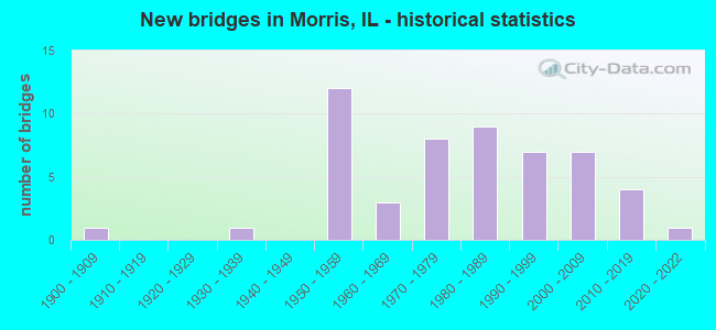
- New bridges - historical statistics
- 11900-1909
- 11930-1939
- 121950-1959
- 31960-1969
- 81970-1979
- 91980-1989
- 71990-1999
- 72000-2009
- 42010-2019
- 12020-2022

- Reconstructed bridges - Historical Statistics
- 41990-1999
- 12000-2009


- Bridge Condition - Deck
- 2.6%Excellent
- 23.7%Very good
- 36.8%Good
- 13.2%Satisfactory
- 10.5%Fair
- 10.5%Poor
- 2.6%Serious

- Bridge Condition - Superstructure
- 2.6%Excellent
- 28.9%Very good
- 21.1%Good
- 26.3%Satisfactory
- 13.2%Fair
- 2.6%Poor
- 5.3%Serious

- Bridge Condition - Substructure
- 2.6%Excellent
- 36.8%Very good
- 31.6%Good
- 2.6%Satisfactory
- 23.7%Fair
- 2.6%Poor

- Bridge Condition - Channel
- 5.6%Excellent
- 25.0%Very good
- 30.6%Good
- 30.6%Satisfactory
- 5.6%Fair
- 2.8%Poor
Find on map >> Show street view
Structure Number: 327009, Location: 300 FT W NETTLE ST (Lat: 41.359050, Lng: -88.429631), Route carried "on" structure: Other road , Year Built: 1964, Status: Open, Structure Length: 1.13m (3.71ft), Average Daily Traffic: 3,850 (year 2019), Truck Traffic: 5%, Average Future Daily Traffic: 5,519 (year 2032), Features Intersected: NETTLE CR, Facility Carried by Structure: JEFFERSON ST
Minimum Vertical Clearance: 30+ m (98+ ft), Kilometerpoint: 0.789, Lanes on structure: 2, Base Highway Network: Yes, Owner: City or Municipal Highway Agency, Approaching Roadway Width: 12.2m (40.0ft), Material/Design: Concrete, Design/Construction: Culvert, Number Of Spans In Main Unit: 1, Length of Maximum Span: 9.1m (29.9ft), Curb or Sidewalk Widths: Left: 1.8m (5.9ft), Right: 1.8m (5.9ft), Curb-To-Curb Width: 12.2m (40.0ft), Out-to-Out Width: 18.9m (62.0ft)
Condition: Channel: Good, Culverts: Good, Operating Rating: 40.5 metric tons, Method Used To Determine Operating Rating: Field evaluation and documented engineering judgment, Inventory Rating: 24.3 metric tons, Method Used To Determine Inventory Rating: Field evaluation and documented engineering judgment, Structural Evaluation: Equal to present minimum criteria, Deck Geometry: Equal to present minimum criteria, Waterway Adequacy: Equal to present desirable criteria, Approach Roadway Alignment: Equal to present desirable criteria, Designated Inspection Frequency: Every 24 months, Inspection Date: June 2021, Deck Structure Type: Concrete Cast-file-Place, Wearing Surface/Protective System: Wearing Surface: Bituminous
Find on map >> Show street view
Structure Number: 32701, Location: 150' E OF WASHINGTON (Lat: 41.365108, Lng: -88.404075), Route carried "on" structure: Other road , Year Built: 1990, Status: Open, Structure Length: 2.56m (8.40ft), Average Daily Traffic: 900 (year 2019), Truck Traffic: 16%, Average Future Daily Traffic: 1,309 (year 2032), Design Load: HS 20, Features Intersected: I&M CANAL, Facility Carried by Structure: ARMSTRONG STREET
Minimum Vertical Clearance: 30+ m (98+ ft), Kilometerpoint: 1.497, Lanes on structure: 2, Owner: City or Municipal Highway Agency, Approaching Roadway Width: 10.0m (32.8ft), Skew: 2 degrees, Material/Design: Concrete, Design/Construction: Channel Beam, Number Of Spans In Main Unit: 3, Length of Maximum Span: 8.9m (29.2ft), Curb or Sidewalk Widths: Left: 1.6m (5.2ft), Right: 1.6m (5.2ft), Curb-To-Curb Width: 10.0m (32.8ft), Out-to-Out Width: 13.7m (44.9ft)
Condition: Deck: Satisfactory, Superstructure: Satisfactory, Substructure: Very good, Channel: Very good, Operating Rating: 57.3 metric tons, Method Used To Determine Operating Rating: Load Factor (LF) rating reported by rating factor (RF) method using MS18 loading, Inventory Rating: 34.0 metric tons, Method Used To Determine Inventory Rating: Load Factor (LF) rating reported by rating factor (RF) method using MS18 loading, Structural Evaluation: Equal to present minimum criteria, Deck Geometry: Equal to present minimum criteria, Waterway Adequacy: Equal to present desirable criteria, Approach Roadway Alignment: Equal to present desirable criteria, Designated Inspection Frequency: Every 24 months, Inspection Date: June 2021, Deck Structure Type: Concrete Precast Panels, Wearing Surface/Protective System: Wearing Surface: Bituminous, Deck Protection: Epoxy Coated Reinforcing
Find on map >> Show street view
Structure Number: 327011, Location: E OF UNION ST (Lat: 41.371133, Lng: -88.430247), Route carried "on" structure: City street , Year Built: 1975, Status: Open, Structure Length: 2.13m (6.99ft), Average Daily Traffic: 2,450 (year 2019), Truck Traffic: 4%, Average Future Daily Traffic: 2,333 (year 2032), Design Load: HS 20, Features Intersected: NETTLE CREEK, Facility Carried by Structure: WAVERLY STREET
Minimum Vertical Clearance: 30+ m (98+ ft), Kilometerpoint: 0.113, Lanes on structure: 2, Owner: City or Municipal Highway Agency, Approaching Roadway Width: 11.9m (39.0ft), Material/Design: Concrete, Design/Construction: Slab, Number Of Spans In Main Unit: 2, Length of Maximum Span: 10.2m (33.5ft), Curb or Sidewalk Widths: Left: 1.5m (4.9ft), Right: 1.5m (4.9ft), Curb-To-Curb Width: 11.9m (39.0ft), Out-to-Out Width: 15.5m (50.9ft)
Condition: Deck: Good, Superstructure: Good, Substructure: Good, Channel: Satisfactory, Operating Rating: 56.7 metric tons, Method Used To Determine Operating Rating: Load Factor (LF) rating reported by rating factor (RF) method using MS18 loading, Inventory Rating: 34.0 metric tons, Method Used To Determine Inventory Rating: Load Factor (LF) rating reported by rating factor (RF) method using MS18 loading, Structural Evaluation: Better than present minimum criteria, Deck Geometry: Somewhat better than minimum adequacy, Waterway Adequacy: Equal to present minimum criteria, Approach Roadway Alignment: Equal to present desirable criteria, Designated Inspection Frequency: Every 48 months, Inspection Date: June 2021, Deck Structure Type: Concrete Precast Panels, Wearing Surface/Protective System: Wearing Surface: Bituminous, Membrane: Built-up
Find on map >> Show street view
Structure Number: 327012, Location: .03M S OF THOMAS DR. (Lat: 41.375369, Lng: -88.437489), Route carried "on" structure: Other road , Year Built: 2000, Status: Open, Structure Length: 2.77m (9.09ft), Average Daily Traffic: 1,350 (year 2019), Truck Traffic: 8%, Average Future Daily Traffic: 2,048 (year 2032), Design Load: HS 20, Features Intersected: E FORK NETTLE CREEK, Facility Carried by Structure: CREEK DR./MS 1115
Minimum Vertical Clearance: 30+ m (98+ ft), Kilometerpoint: 0.756, Lanes on structure: 2, Owner: City or Municipal Highway Agency, Approaching Roadway Width: 10.7m (35.1ft), Material/Design: Concrete, Design/Construction: Channel Beam, Number Of Spans In Main Unit: 3, Length of Maximum Span: 10.1m (33.1ft), Curb or Sidewalk Widths: Left: 1.8m (5.9ft), Right: 1.8m (5.9ft), Curb-To-Curb Width: 10.7m (35.1ft), Out-to-Out Width: 14.9m (48.9ft)
Condition: Deck: Good, Superstructure: Satisfactory, Substructure: Very good, Channel: Good, Operating Rating: 44.1 metric tons, Method Used To Determine Operating Rating: Assigned rating based on Load Factor Design (LFD) reported by rating factor (RF) using MS18 loading, Inventory Rating: 32.4 metric tons, Method Used To Determine Inventory Rating: Assigned rating based on Load Factor Design (LFD) reported by rating factor (RF) using MS18 loading, Structural Evaluation: Equal to present minimum criteria, Deck Geometry: Equal to present minimum criteria, Waterway Adequacy: Superior to present desirable criteria, Approach Roadway Alignment: Better than present minimum criteria, Designated Inspection Frequency: Every 24 months, Inspection Date: June 2021, Deck Structure Type: Concrete Precast Panels, Wearing Surface/Protective System: Wearing Surface: Bituminous, Membrane: Built-up, Deck Protection: Epoxy Coated Reinforcing
Find on map >> Show street view
Structure Number: 327099, Location: Wm. G. Stratton SP (Lat: 41.356000, Lng: -88.416642), Route carried "on" structure: Other road , Year Built: 2020, Status: Open, Structure Length: 3.01m (9.88ft), Average Daily Traffic: 300 (year 2019), Truck Traffic: 12%, Average Future Daily Traffic: 370 (year 2032), Design Load: HS 25 or greater, Features Intersected: I & M Canal, Facility Carried by Structure: PRICE ST
Minimum Vertical Clearance: 30+ m (98+ ft), Kilometerpoint: 0.048, Lanes on structure: 2, Owner: State Park, Forest, or Reservation Agency, Approaching Roadway Width: 6.7m (22.0ft), Material/Design: Prestressed concrete, Design/Construction: Box Beam or Girders - Multiple, Number Of Spans In Main Unit: 3, Length of Maximum Span: 0.0m, Curb or Sidewalk Widths: Left: 0.0m, Right: 1.7m (5.6ft), Curb-To-Curb Width: 6.7m (22.0ft), Out-to-Out Width: 9.1m (29.9ft)
Condition: Deck: Excellent, Superstructure: Excellent, Substructure: Excellent, Channel: Excellent, Operating Rating: 56.1 metric tons, Method Used To Determine Operating Rating: Load and Resistance Factor Rating (LRFR) rating reported by rating factor(RF) method using HL-93 loadings, Inventory Rating: 43.4 metric tons, Method Used To Determine Inventory Rating: Load and Resistance Factor Rating (LRFR) rating reported by rating factor(RF) method using HL-93 loadings, Structural Evaluation: Superior to present desirable criteria, Deck Geometry: Meets minimum limits, Waterway Adequacy: Superior to present desirable criteria, Approach Roadway Alignment: Equal to present desirable criteria, Designated Inspection Frequency: Every 24 months, Inspection Date: March 2021, Deck Structure Type: Concrete Precast Panels, Wearing Surface/Protective System: Wearing Surface: Integral Concrete, Membrane: Built-up, Deck Protection: Epoxy Coated Reinforcing
Find on map >> Show street view
Structure Number: 320055, Location: 3.19 MI W OF ILL 47 (Lat: 41.378031, Lng: -88.479611), Route carried "under" structure: Interstate 80, Year Built: 1958, Structure Length: 0. m, Average Daily Traffic: 30,700 (year 2021), Truck Traffic: 27%, Features Intersected: FAI 80, Facility Carried by Structure: Saratoga Rd / TR 8
Minimum Vertical Clearance: 5.16m (16.93ft), Kilometerpoint: 175.301, Lanes on structure: 2, Lanes under structure: 4, Material/Design: Concrete continuous, Design/Construction: Tee Beam, Length of Maximum Span: 17.0m (55.8ft)
Find on map >> Show street view
Structure Number: 320056, Location: 2.21 MI W ILL 47 (Lat: 41.378261, Lng: -88.460769), Route carried "under" structure: Interstate 80, Year Built: 1958, Structure Length: 0. m, Average Daily Traffic: 30,700 (year 2021), Truck Traffic: 27%, Features Intersected: FAI 80, Facility Carried by Structure: Ashton Rd / TR 106
Minimum Vertical Clearance: 5.16m (16.93ft), Kilometerpoint: 176.878, Lanes on structure: 2, Lanes under structure: 4, Material/Design: Concrete continuous, Design/Construction: Tee Beam, Length of Maximum Span: 17.0m (55.8ft)
Find on map >> Show street view
Structure Number: 320064, Location: 4.20 MI W OF ILL 47 (Lat: 41.377789, Lng: -88.498981), Route carried "under" structure: Interstate 80, Year Built: 1958, Structure Length: 0. m, Average Daily Traffic: 30,700 (year 2021), Truck Traffic: 27%, Features Intersected: FAI 80, Facility Carried by Structure: Pioneer Rd / TR 78
Minimum Vertical Clearance: 5.16m (16.93ft), Kilometerpoint: 173.676, Lanes on structure: 2, Lanes under structure: 4, Material/Design: Concrete continuous, Design/Construction: Tee Beam, Length of Maximum Span: 17.0m (55.8ft)
Find on map >> Show street view
Structure Number: 320086, Location: .57 S OF US 6 WEST (Lat: 41.362894, Lng: -88.422233), Route carried "under" structure: City street , Year Built: 1978, Structure Length: 0. m, Average Daily Traffic: 2,300 (year 2019), Truck Traffic: 9%, Features Intersected: ARMSTRONG & B & O RR, Facility Carried by Structure: ILL 47
Minimum Vertical Clearance: 8.20m (26.90ft), Kilometerpoint: 0.000, Lanes on structure: 4, Lanes under structure: 2, Material/Design: Steel continuous, Design/Construction: Stringer/Multi-beam, Length of Maximum Span: 21.9m (71.9ft)
Find on map >> Show street view
Structure Number: 320087, Location: ILL 47 IN MORRIS (Lat: 41.366028, Lng: -88.420739), Route carried "under" structure: City street , Year Built: 1978, Structure Length: 0. m, Average Daily Traffic: 475 (year 2019), Truck Traffic: 11%, Features Intersected: BUCHANAN ST, Facility Carried by Structure: ILL 47
Minimum Vertical Clearance: 5.16m (16.93ft), Kilometerpoint: 0.306, Lanes on structure: 4, Lanes under structure: 2, Material/Design: Steel continuous, Design/Construction: Stringer/Multi-beam, Length of Maximum Span: 14.9m (48.9ft)
Find on map >> Show street view
Structure Number: 320095, Location: INTER I80 & ILL47 (Lat: 41.388567, Lng: -88.422356), Route carried "under" structure: Interstate 80, Year Built: 1997, Structure Length: 0. m, Average Daily Traffic: 36,900 (year 2021), Truck Traffic: 30%, Features Intersected: I 80, Facility Carried by Structure: ILL 47
Minimum Vertical Clearance: 4.95m (16.24ft), Kilometerpoint: 180.435, Lanes on structure: 4, Lanes under structure: 4, Material/Design: Steel continuous, Design/Construction: Stringer/Multi-beam, Length of Maximum Span: 28.2m (92.5ft)
Find on map >> Show street view
Structure Number: 320113, Location: 1.24 MI E OF IL 47 (Lat: 41.399369, Lng: -88.403181), Route carried "under" structure: Interstate 80, Year Built: 2006, Structure Length: 0. m, Average Daily Traffic: 36,900 (year 2021), Truck Traffic: 30%, Features Intersected: I-80, Facility Carried by Structure: ASHLEY RD/FAU 5974
Minimum Vertical Clearance: 5.31m (17.42ft), Kilometerpoint: 182.430, Lanes on structure: 2, Lanes under structure: 4, Material/Design: Steel continuous, Design/Construction: Stringer/Multi-beam, Length of Maximum Span: 37.1m (121.7ft)
Find on map >> Show street view
Structure Number: 320124, Location: 0.70 mi W of IL 47 (Lat: 41.382681, Lng: -88.432811), Route carried "under" structure: Interstate 80, Year Built: 2015, Structure Length: 0. m, Average Daily Traffic: 30,700 (year 2021), Truck Traffic: 27%, Features Intersected: I-80, Facility Carried by Structure: Lisbon Rd (FAU 596
Minimum Vertical Clearance: 5.44m (17.85ft), Kilometerpoint: 179.324, Lanes on structure: 2, Lanes under structure: 4, Material/Design: Steel continuous, Design/Construction: Stringer/Multi-beam, Length of Maximum Span: 31.5m (103.3ft)
Find on map >> Show street view
Structure Number: 327001, Location: CRI&P RR OV LISBON S (Lat: 41.363531, Lng: -88.426367), Route carried "under" structure: Other road , Year Built: 1900, Structure Length: 0. m, Average Daily Traffic: 3,150 (year 2019), Truck Traffic: 7%, Features Intersected: LISBON ST, Facility Carried by Structure: CRI&P RR
Minimum Vertical Clearance: 3.40m (11.15ft), Kilometerpoint: 0.998, Lanes under structure: 2, Material/Design: Steel, Design/Construction: Stringer/Multi-beam, Length of Maximum Span: 8.5m (27.9ft)