Bridge Statistics for Muncy, Pennsylvania (PA)
Condition, Traffic, Stress, Structural Evaluation, Project Costs
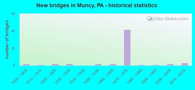
- New bridges - historical statistics
- 21900-1909
- 11910-1919
- 21920-1929
- 21930-1939
- 21950-1959
- 21960-1969
- 421970-1979
- 11980-1989
- 11990-1999
- 22000-2009
- 32010-2019

- Reconstructed bridges - Historical Statistics
- 31980-1989
- 101990-1999
- 12000-2009
- 12010-2019
- 12020-2022


- Bridge Condition - Deck
- 25.0%Very good
- 44.4%Good
- 16.7%Satisfactory
- 13.9%Fair

- Bridge Condition - Superstructure
- 13.5%Very good
- 37.8%Good
- 35.1%Satisfactory
- 10.8%Fair
- 2.7%Imminent failure

- Bridge Condition - Substructure
- 56.8%Good
- 32.4%Satisfactory
- 8.1%Fair
- 2.7%Critical

- Bridge Condition - Channel
- 10.3%Very good
- 17.2%Good
- 31.0%Satisfactory
- 27.6%Fair
- 13.8%Poor

- Bridge Condition - Culverts
- 40.0%Very good
- 60.0%Good
Find on map >> Show street view
Structure Number: 46776, Location: 1.9 MI. N. OF PENNSDALE (Lat: 41.269661, Lng: -76.798228), Route carried "on" structure: City street , Year Built: 2011, Status: Open, Structure Length: 0.73m (2.40ft), Average Daily Traffic: 100 (year 2019), Truck Traffic: 5%, Average Future Daily Traffic: 154 (year 2041), Design Load: HS 25 or greater, Features Intersected: CARPENTERS RUN, Facility Carried by Structure: T-549 BUGBEE RD
Minimum Vertical Clearance: 30+ m (98+ ft), Kilometerpoint: 0.000, Lanes on structure: 2, Owner: Town or Township Highway Agency, Approaching Roadway Width: 6.7m (22.0ft), Material/Design: Concrete, Design/Construction: Culvert, Number Of Spans In Main Unit: 1, Length of Maximum Span: 7.3m (24.0ft)
Condition: Channel: Satisfactory, Culverts: Very good, Operating Rating: 75.3 metric tons, Method Used To Determine Operating Rating: Assigned rating based on Load Factor Design (LFD) reported in metric tons, Inventory Rating: 58.1 metric tons, Method Used To Determine Inventory Rating: Assigned rating based on Load Factor Design (LFD) reported in metric tons, Structural Evaluation: Equal to present desirable criteria, Waterway Adequacy: Better than present minimum criteria, Approach Roadway Alignment: Equal to present desirable criteria, Designated Inspection Frequency: Every 24 months, Inspection Date: September 2021
Find on map >> Show street view
Structure Number: 47209, Location: 1 MI S OF PENNSDALE (Lat: 41.235139, Lng: -76.793389), Route carried "on" structure: State highway , Year Built: 2012, Status: Open, Structure Length: 1.74m (5.71ft), Average Daily Traffic: 621 (year 2020), Truck Traffic: 6%, Average Future Daily Traffic: 1,127 (year 2032), Design Load: HL 93, Features Intersected: WOLF RUN, Facility Carried by Structure: SR 2051
Minimum Vertical Clearance: 30+ m (98+ ft), Kilometerpoint: 1.339, Lanes on structure: 2, Owner: State Highway Agency, Approaching Roadway Width: 5.8m (19.0ft), Skew: 4 degrees, Material/Design: Prestressed concrete, Design/Construction: Box Beam or Girders - Single/Spread, Number Of Spans In Main Unit: 1, Length of Maximum Span: 16.8m (55.1ft), Curb or Sidewalk Widths: Left: 0.2m (0.7ft), Right: 0.2m (0.7ft), Curb-To-Curb Width: 8.5m (27.9ft), Out-to-Out Width: 9.6m (31.5ft)
Condition: Deck: Very good, Superstructure: Very good, Substructure: Good, Channel: Satisfactory, Operating Rating: 58.3 metric tons, Method Used To Determine Operating Rating: Assigned ratings based on Load and Resistance Factor Design (LRFD) reported by rating factor (RF) using HL93 loadings, Inventory Rating: 36.6 metric tons, Method Used To Determine Inventory Rating: Assigned ratings based on Load and Resistance Factor Design (LRFD) reported by rating factor (RF) using HL93 loadings, Structural Evaluation: Better than present minimum criteria, Deck Geometry: Somewhat better than minimum adequacy, Waterway Adequacy: Better than present minimum criteria, Approach Roadway Alignment: Equal to present desirable criteria, Designated Inspection Frequency: Every 48 months, Inspection Date: January 2020, Deck Structure Type: Concrete Cast-file-Place, Wearing Surface/Protective System: Wearing Surface: Epoxy Overlay, Deck Protection: Epoxy Coated Reinforcing
Find on map >> Show street view
Structure Number: 54646, Location: 2 MI SW OF MUNCY (Lat: 41.194661, Lng: -76.824611), Route carried "on" structure: State highway 405, Year Built: 2017, Status: Open, Structure Length: 0.79m (2.59ft), Average Daily Traffic: 3,968 (year 2020), Truck Traffic: 9%, Average Future Daily Traffic: 7,429 (year 2037), Design Load: HL 93, Features Intersected: OVER TURKEY RUN
Minimum Vertical Clearance: 30+ m (98+ ft), Kilometerpoint: 4.966, Lanes on structure: 2, Base Highway Network: Yes, Owner: State Highway Agency, Approaching Roadway Width: 14.9m (48.9ft), Material/Design: Concrete, Design/Construction: Culvert, Number Of Spans In Main Unit: 1, Length of Maximum Span: 7.3m (24.0ft)
Condition: Channel: Very good, Culverts: Very good, Operating Rating: 57.7 metric tons, Method Used To Determine Operating Rating: Assigned ratings based on Load and Resistance Factor Design (LRFD) reported by rating factor (RF) using HL93 loadings, Inventory Rating: 36.3 metric tons, Method Used To Determine Inventory Rating: Assigned ratings based on Load and Resistance Factor Design (LRFD) reported by rating factor (RF) using HL93 loadings, Structural Evaluation: Equal to present desirable criteria, Waterway Adequacy: Equal to present minimum criteria, Approach Roadway Alignment: Equal to present desirable criteria, Designated Inspection Frequency: Every 48 months, Inspection Date: October 2019
Find on map >> Show street view
Structure Number: 24659, Location: HALLS STATION (Lat: 41.237781, Lng: -76.809456), Route carried "under" structure: State highway , Year Built: 1975, Structure Length: 0. m, Average Daily Traffic: 4,769 (year 2022), Truck Traffic: 5%, Features Intersected: I 180 OVER SR 2036, Facility Carried by Structure: SR-0180,
Minimum Vertical Clearance: 30+ m (98+ ft), Kilometerpoint: 0.737, Lanes on structure: 2, Lanes under structure: 1, Material/Design: Prestressed concrete, Design/Construction: Stringer/Multi-beam, Length of Maximum Span: 30.2m (99.1ft)
Find on map >> Show street view
Structure Number: 24659, Location: HALLS STATION (Lat: 41.237781, Lng: -76.809456), Route carried "under" structure: State highway , Year Built: 1975, Structure Length: 0. m, Average Daily Traffic: 4,769 (year 2022), Truck Traffic: 5%, Features Intersected: I 180 OVER SR 2036, Facility Carried by Structure: SR-0180,
Minimum Vertical Clearance: 4.50m (14.76ft), Kilometerpoint: 0.737, Lanes on structure: 2, Lanes under structure: 1, Material/Design: Prestressed concrete, Design/Construction: Stringer/Multi-beam, Length of Maximum Span: 30.2m (99.1ft)
Find on map >> Show street view
Structure Number: 2466, Location: HALLS STATION (Lat: 41.237917, Lng: -76.809175), Route carried "under" structure: US 220, Year Built: 1975, Structure Length: 0. m, Average Daily Traffic: 4,081 (year 2022), Truck Traffic: 7%, Features Intersected: OVER SR 0220, Facility Carried by Structure: SR-0180,WB
Minimum Vertical Clearance: 30+ m (98+ ft), Kilometerpoint: 22.846, Lanes on structure: 2, Lanes under structure: 1, Material/Design: Prestressed concrete, Design/Construction: Stringer/Multi-beam, Length of Maximum Span: 30.2m (99.1ft)
Find on map >> Show street view
Structure Number: 2466, Location: HALLS STATION (Lat: 41.237917, Lng: -76.809175), Route carried "under" structure: US 220, Year Built: 1975, Structure Length: 0. m, Average Daily Traffic: 4,081 (year 2022), Truck Traffic: 7%, Features Intersected: OVER SR 0220, Facility Carried by Structure: SR-0180,WB
Minimum Vertical Clearance: 4.50m (14.76ft), Kilometerpoint: 22.846, Lanes on structure: 2, Lanes under structure: 1, Material/Design: Prestressed concrete, Design/Construction: Stringer/Multi-beam, Length of Maximum Span: 30.2m (99.1ft)
Find on map >> Show street view
Structure Number: 24668, Location: 1 MI E OF MUNCY (Lat: 41.210756, Lng: -76.770975), Route carried "under" structure: State highway 405, Year Built: 1973, Structure Length: 0. m, Average Daily Traffic: 14,203 (year 2021), Truck Traffic: 11%, Features Intersected: E.B. OVER S.R. 405, Facility Carried by Structure: I 180 EB
Minimum Vertical Clearance: 4.57m (14.99ft), Kilometerpoint: 10.084, Lanes on structure: 2, Lanes under structure: 2, Material/Design: Prestressed concrete, Design/Construction: Stringer/Multi-beam, Length of Maximum Span: 32.3m (106.0ft)
Find on map >> Show street view
Structure Number: 24669, Location: 1 MI E OF MUNCY (Lat: 41.207278, Lng: -76.769208), Route carried "under" structure: State highway , Year Built: 1973, Structure Length: 0. m, Average Daily Traffic: 3,179 (year 2021), Truck Traffic: 1%, Features Intersected: E.B. OVER S.R. 2044, Facility Carried by Structure: I 180 EB
Minimum Vertical Clearance: 4.75m (15.58ft), Kilometerpoint: 1.548, Lanes on structure: 2, Lanes under structure: 2, Material/Design: Prestressed concrete, Design/Construction: Stringer/Multi-beam, Length of Maximum Span: 22.3m (73.2ft)
Find on map >> Show street view
Structure Number: 2467, Location: 1 MI E OF MUNCY (Lat: 41.210861, Lng: -76.770711), Route carried "under" structure: State highway 405, Year Built: 1973, Structure Length: 0. m, Average Daily Traffic: 14,203 (year 2021), Truck Traffic: 11%, Features Intersected: W.B. OVER S.R. 405, Facility Carried by Structure: I 180 WB
Minimum Vertical Clearance: 4.80m (15.75ft), Kilometerpoint: 10.084, Lanes on structure: 2, Lanes under structure: 2, Material/Design: Prestressed concrete, Design/Construction: Stringer/Multi-beam, Length of Maximum Span: 32.3m (106.0ft)
Find on map >> Show street view
Structure Number: 24671, Location: 1 MI E OF MUNCY (Lat: 41.207408, Lng: -76.768931), Route carried "under" structure: State highway , Year Built: 1973, Structure Length: 0. m, Average Daily Traffic: 3,179 (year 2021), Truck Traffic: 1%, Features Intersected: W.B. OVER S.R. 2044, Facility Carried by Structure: I 180 WB
Minimum Vertical Clearance: 5.36m (17.59ft), Kilometerpoint: 1.548, Lanes on structure: 2, Lanes under structure: 2, Material/Design: Prestressed concrete, Design/Construction: Stringer/Multi-beam, Length of Maximum Span: 22.3m (73.2ft)
Find on map >> Show street view
Structure Number: 24672, Location: 1 MI SE OF MUNCY (Lat: 41.201361, Lng: -76.769075), Route carried "under" structure: State highway , Year Built: 1973, Structure Length: 0. m, Average Daily Traffic: 1,235 (year 2022), Truck Traffic: 2%, Features Intersected: E.B. OVER S.R. 2061, Facility Carried by Structure: I 180 EB
Minimum Vertical Clearance: 4.54m (14.90ft), Kilometerpoint: 1.230, Lanes on structure: 2, Lanes under structure: 2, Material/Design: Prestressed concrete, Design/Construction: Stringer/Multi-beam, Length of Maximum Span: 31.7m (104.0ft)
Find on map >> Show street view
Structure Number: 24673, Location: 1 MI SE OF MUNCY (Lat: 41.201353, Lng: -76.768772), Route carried "under" structure: State highway , Year Built: 1973, Structure Length: 0. m, Average Daily Traffic: 1,235 (year 2022), Truck Traffic: 2%, Features Intersected: W.B. OVER S.R. 2061, Facility Carried by Structure: I 180 WB
Minimum Vertical Clearance: 4.45m (14.60ft), Kilometerpoint: 1.230, Lanes on structure: 2, Lanes under structure: 2, Material/Design: Prestressed concrete, Design/Construction: Stringer/Multi-beam, Length of Maximum Span: 31.7m (104.0ft)
Find on map >> Show street view
Structure Number: 24675, Location: .5 MI S OF MUNCY (Lat: 41.187631, Lng: -76.785247), Route carried "under" structure: State highway , Year Built: 1973, Structure Length: 0. m, Average Daily Traffic: 1,763 (year 2021), Truck Traffic: 7%, Features Intersected: E.B. OVER S.R. 2014, Facility Carried by Structure: SR 0180
Minimum Vertical Clearance: 4.57m (14.99ft), Kilometerpoint: 30.825, Lanes on structure: 2, Lanes under structure: 2, Material/Design: Prestressed concrete, Design/Construction: Stringer/Multi-beam, Length of Maximum Span: 32.0m (105.0ft)
Find on map >> Show street view
Structure Number: 24676, Location: .5 MI S OF MUNCY (Lat: 41.187319, Lng: -76.785294), Route carried "under" structure: State highway , Year Built: 1973, Structure Length: 0. m, Average Daily Traffic: 1,763 (year 2021), Truck Traffic: 7%, Features Intersected: W.B. OVER S.R. 2014, Facility Carried by Structure: SR 0180
Minimum Vertical Clearance: 4.52m (14.83ft), Kilometerpoint: 30.825, Lanes on structure: 2, Lanes under structure: 2, Material/Design: Prestressed concrete, Design/Construction: Stringer/Multi-beam, Length of Maximum Span: 32.0m (105.0ft)
Find on map >> Show street view
Structure Number: 24927, Location: LYCOMING MALL INTERCHANGE (Lat: 41.246294, Lng: -76.832931), Route carried "under" structure: Interstate 180, Year Built: 1974, Structure Length: 0. m, Average Daily Traffic: 13,487 (year 2021), Truck Traffic: 14%, Features Intersected: OVER I-180 & RAMP B, Facility Carried by Structure: SR2049
Minimum Vertical Clearance: 5.61m (18.41ft), Kilometerpoint: 19.090, Lanes on structure: 2, Lanes under structure: 5, Material/Design: Prestressed concrete, Design/Construction: Stringer/Multi-beam, Length of Maximum Span: 32.3m (106.0ft)
Find on map >> Show street view
Structure Number: 24927, Location: LYCOMING MALL INTERCHANGE (Lat: 41.246294, Lng: -76.832931), Route carried "under" structure: Interstate 180, Year Built: 1974, Structure Length: 0. m, Average Daily Traffic: 11,385 (year 2021), Truck Traffic: 14%, Features Intersected: OVER I-180 & RAMP B, Facility Carried by Structure: SR2049
Minimum Vertical Clearance: 5.61m (18.41ft), Kilometerpoint: 19.143, Lanes on structure: 2, Lanes under structure: 5, Material/Design: Prestressed concrete, Design/Construction: Stringer/Multi-beam, Length of Maximum Span: 32.3m (106.0ft)
Find on map >> Show street view
Structure Number: 24931, Location: 1 MI N OF MUNCY (Lat: 41.222053, Lng: -76.787011), Route carried "under" structure: Interstate 180, Year Built: 1973, Structure Length: 0. m, Average Daily Traffic: 9,440 (year 2021), Truck Traffic: 20%, Features Intersected: OVER LR 1073 (I-180), Facility Carried by Structure: S.R.2053
Minimum Vertical Clearance: 5.05m (16.57ft), Kilometerpoint: 23.937, Lanes on structure: 2, Lanes under structure: 4, Material/Design: Prestressed concrete, Design/Construction: Stringer/Multi-beam, Length of Maximum Span: 26.8m (87.9ft)
Find on map >> Show street view
Structure Number: 24931, Location: 1 MI N OF MUNCY (Lat: 41.222053, Lng: -76.787011), Route carried "under" structure: Interstate 180, Year Built: 1973, Structure Length: 0. m, Average Daily Traffic: 9,624 (year 2021), Truck Traffic: 17%, Features Intersected: OVER LR 1073 (I-180), Facility Carried by Structure: S.R.2053
Minimum Vertical Clearance: 5.05m (16.57ft), Kilometerpoint: 23.939, Lanes on structure: 2, Lanes under structure: 4, Material/Design: Prestressed concrete, Design/Construction: Stringer/Multi-beam, Length of Maximum Span: 26.8m (87.9ft)
Find on map >> Show street view
Structure Number: 29064, Location: 2.5 MI.SOUTH OF MUNCY (Lat: 41.162283, Lng: -76.793519), Route carried "under" structure: Interstate 180, Year Built: 1970, Structure Length: 0. m, Average Daily Traffic: 8,967 (year 2021), Truck Traffic: 24%, Features Intersected: 1045 OVER I-180 EB & WB, Facility Carried by Structure: T-666
Minimum Vertical Clearance: 5.04m (16.54ft), Kilometerpoint: 1.365, Lanes on structure: 2, Lanes under structure: 4, Material/Design: Prestressed concrete, Design/Construction: Stringer/Multi-beam, Length of Maximum Span: 29.0m (95.1ft)
Find on map >> Show street view
Structure Number: 29064, Location: 2.5 MI.SOUTH OF MUNCY (Lat: 41.162283, Lng: -76.793519), Route carried "under" structure: Interstate 180, Year Built: 1970, Structure Length: 0. m, Average Daily Traffic: 8,837 (year 2021), Truck Traffic: 18%, Features Intersected: 1045 OVER I-180 EB & WB, Facility Carried by Structure: T-666
Minimum Vertical Clearance: 5.04m (16.54ft), Kilometerpoint: 1.408, Lanes on structure: 2, Lanes under structure: 4, Material/Design: Prestressed concrete, Design/Construction: Stringer/Multi-beam, Length of Maximum Span: 29.0m (95.1ft)