Bridge Statistics for Natchitoches, Louisiana (LA)
Condition, Traffic, Stress, Structural Evaluation, Project Costs
- National Bridge Inventory (NBI) Statistics
- 69Number of bridges
- 1,096ft / 334mTotal length
- $5,107,000Total costs
- 417,997Total average daily traffic
- 60,429Total average daily truck traffic
- National Bridge Inventory (NBI) Registered Bridges for Natchitoches
- No street view available for this location
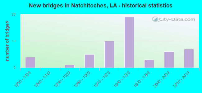
- New bridges - historical statistics
- 41930-1939
- 11950-1959
- 51960-1969
- 101970-1979
- 191980-1989
- 31990-1999
- 62000-2009
- 72010-2019
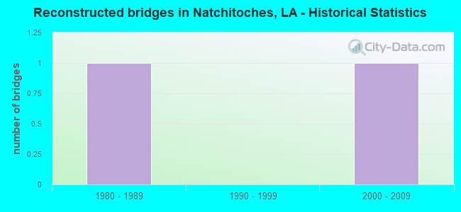
- Reconstructed bridges - Historical Statistics
- 11980-1989
- 01990-1999
- 12000-2009
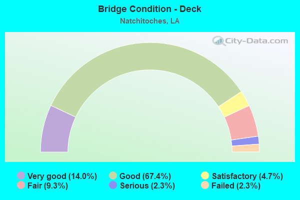
- Bridge Condition - Deck
- 14.0%Very good
- 67.4%Good
- 4.7%Satisfactory
- 9.3%Fair
- 2.3%Serious
- 2.3%Failed
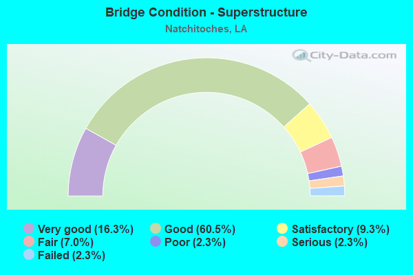
- Bridge Condition - Superstructure
- 16.3%Very good
- 60.5%Good
- 9.3%Satisfactory
- 7.0%Fair
- 2.3%Poor
- 2.3%Serious
- 2.3%Failed
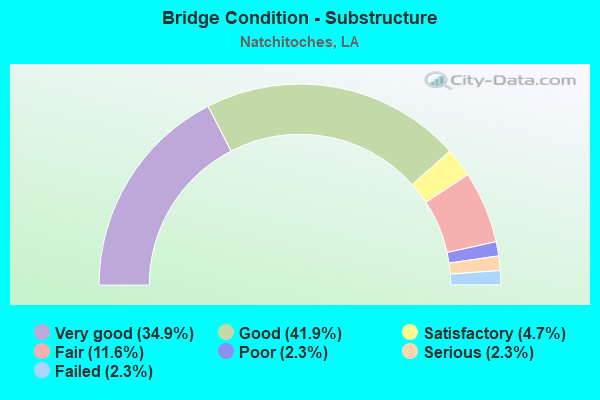
- Bridge Condition - Substructure
- 34.9%Very good
- 41.9%Good
- 4.7%Satisfactory
- 11.6%Fair
- 2.3%Poor
- 2.3%Serious
- 2.3%Failed
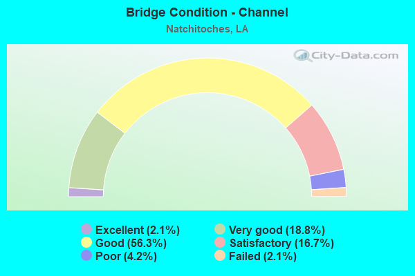
- Bridge Condition - Channel
- 2.1%Excellent
- 18.8%Very good
- 56.3%Good
- 16.7%Satisfactory
- 4.2%Poor
- 2.1%Failed
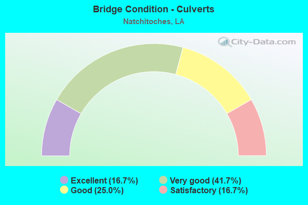
- Bridge Condition - Culverts
- 16.7%Excellent
- 41.7%Very good
- 25.0%Good
- 16.7%Satisfactory
Find on map >> Show street view
Structure Number: 83504550631401, Location: 1.9 MI N OF LA 6 (Lat: 31.755069, Lng: -93.175300), Route carried "on" structure: County highway , Year Built: 1986, Status: Open, Structure Length: 8.93m (29.30ft), Average Daily Traffic: 15,900 (year 2016), Truck Traffic: 30%, Average Future Daily Traffic: 11,016 (year 2036), Design Load: HS 20, Features Intersected: I-49, Facility Carried by Structure: EIGHT MILE LP
Minimum Vertical Clearance: 30+ m (98+ ft), Kilometerpoint: 50.574, Lanes on structure: 2, Lanes under structure: 4, Owner: State Highway Agency, Approaching Roadway Width: 8.5m (27.9ft), Skew: 36 degrees, Material/Design: Prestressed concrete continuous, Design/Construction: Stringer/Multi-beam, Number Of Spans In Main Unit: 2, Number Of Approach Spans: 2, Length of Maximum Span: 29.9m (98.1ft), Curb-To-Curb Width: 8.5m (27.9ft), Out-to-Out Width: 9.4m (30.8ft)
Condition: Deck: Good, Superstructure: Very good, Substructure: Good, Operating Rating: 39.9 metric tons, Method Used To Determine Operating Rating: Allowable Stress (AS), Inventory Rating: 32.7 metric tons, Method Used To Determine Inventory Rating: Allowable Stress (AS), Structural Evaluation: Better than present minimum criteria, Deck Geometry: Meets minimum limits, Underclear: Somewhat better than minimum adequacy, Approach Roadway Alignment: Equal to present minimum criteria, Designated Inspection Frequency: Every 24 months, Inspection Date: June 2020, Deck Structure Type: Concrete Cast-file-Place, Wearing Surface/Protective System: Wearing Surface: Monolithic Concrete
Find on map >> Show street view
Structure Number: 83504550633921, Location: 4.42 MI. NORTH OF LA 6 (Lat: 31.786569, Lng: -93.197300), Route carried "on" structure: County highway , Year Built: 1985, Status: Open, Structure Length: 8.47m (27.79ft), Average Daily Traffic: 1,530 (year 2015), Average Future Daily Traffic: 1,101 (year 2036), Design Load: HS 20, Features Intersected: I-49, Facility Carried by Structure: POSEY RD
Minimum Vertical Clearance: 30+ m (98+ ft), Kilometerpoint: 54.628, Lanes on structure: 2, Lanes under structure: 4, Base Highway Network: Yes (Inventory Route: 455-06-1, Subroute: 10), Owner: State Highway Agency, Approaching Roadway Width: 5.8m (19.0ft), Skew: 37 degrees, Material/Design: Steel continuous, Design/Construction: Stringer/Multi-beam, Number Of Spans In Main Unit: 2, Length of Maximum Span: 42.1m (138.1ft), Curb-To-Curb Width: 20.1m (65.9ft), Out-to-Out Width: 21.0m (68.9ft)
Condition: Deck: Good, Superstructure: Satisfactory, Substructure: Very good, Operating Rating: 55.3 metric tons, Method Used To Determine Operating Rating: Load Factor (LF), Inventory Rating: 33.6 metric tons, Method Used To Determine Inventory Rating: Load Factor (LF), Structural Evaluation: Equal to present minimum criteria, Deck Geometry: Superior to present desirable criteria, Underclear: Superior to present desirable criteria, Approach Roadway Alignment: Equal to present desirable criteria, Designated Inspection Frequency: Every 24 months, Inspection Date: June 2020, Deck Structure Type: Concrete Cast-file-Place, Wearing Surface/Protective System: Wearing Surface: Monolithic Concrete
Find on map >> Show street view
Structure Number: 83504550634711, Location: 5.21 MI. NORTH OF LA 6 (Lat: 31.796461, Lng: -93.204300), Route carried "on" structure: Interstate 49, Year Built: 1984, Status: Open, Structure Length: 0.88m (2.89ft), Average Daily Traffic: 16,200 (year 2016), Truck Traffic: 30%, Average Future Daily Traffic: 11,232 (year 2036), Design Load: HS 20, Features Intersected: CREEK
Minimum Vertical Clearance: 30+ m (98+ ft), Kilometerpoint: 55.904, Lanes on structure: 4, Base Highway Network: Yes (Inventory Route: 455-06-1, Subroute: 10), Owner: State Highway Agency, Approaching Roadway Width: 23.2m (76.1ft), Skew: 30 degrees, Material/Design: Concrete, Design/Construction: Culvert, Number Of Spans In Main Unit: 3, Length of Maximum Span: 2.7m (8.9ft), Curb or Sidewalk Widths: Left: 1.2m (3.9ft), Right: 0.0m
Condition: Channel: Good, Culverts: Very good, Operating Rating: 42.1 metric tons, Method Used To Determine Operating Rating: Load and Resistance Factor Rating (LRFR) rating reported by rating factor(RF) method using HL-93 loadings, Inventory Rating: 32.4 metric tons, Method Used To Determine Inventory Rating: Load and Resistance Factor Rating (LRFR) rating reported by rating factor(RF) method using HL-93 loadings, Structural Evaluation: Equal to present desirable criteria, Waterway Adequacy: Superior to present desirable criteria, Approach Roadway Alignment: Equal to present desirable criteria, Designated Inspection Frequency: Every 24 months, Inspection Date: June 2020, Deck Structure Type: Concrete Cast-file-Place
Find on map >> Show street view
Structure Number: 83508350402071, Location: 2.07 MI. EAST OF LA 485 (Lat: 31.746250, Lng: -93.270400), Route carried "on" structure: State highway 1222, Year Built: 1994, Status: Open, Structure Length: 0.67m (2.20ft), Average Daily Traffic: 190 (year 2016), Truck Traffic: 10%, Average Future Daily Traffic: 129 (year 2036), Design Load: HS 20, Features Intersected: MALLARD BAYOU RELIEF
Minimum Vertical Clearance: 30+ m (98+ ft), Kilometerpoint: 3.331, Lanes on structure: 2, Owner: State Highway Agency, Approaching Roadway Width: 7.9m (25.9ft), Skew: 30 degrees, Material/Design: Steel, Design/Construction: Culvert, Number Of Spans In Main Unit: 3, Length of Maximum Span: 1.8m (5.9ft)
Condition: Channel: Good, Culverts: Very good, Operating Rating: 70.6 metric tons, Method Used To Determine Operating Rating: Load and Resistance Factor Rating (LRFR) rating reported by rating factor(RF) method using HL-93 loadings, Inventory Rating: 54.4 metric tons, Method Used To Determine Inventory Rating: Load and Resistance Factor Rating (LRFR) rating reported by rating factor(RF) method using HL-93 loadings, Structural Evaluation: Equal to present desirable criteria, Waterway Adequacy: Better than present minimum criteria, Approach Roadway Alignment: Better than present minimum criteria, Designated Inspection Frequency: Every 24 months, Inspection Date: Febuary 2020
Find on map >> Show street view
Structure Number: 83508350501701, Location: 1.7 MI. N OF INT LA6 (Lat: 31.750811, Lng: -93.155500), Route carried "on" structure: State highway 504, Year Built: 2005, Status: Open, Structure Length: 5.49m (18.01ft), Average Daily Traffic: 3,300 (year 2016), Truck Traffic: 8%, Average Future Daily Traffic: 2,664 (year 2036), Design Load: HS 20, Features Intersected: SIBLEY LAKE
Minimum Vertical Clearance: 30+ m (98+ ft), Kilometerpoint: 2.929, Lanes on structure: 2, Owner: State Highway Agency, Approaching Roadway Width: 8.8m (28.9ft), Skew: 30 degrees, Material/Design: Concrete, Design/Construction: Slab, Number Of Spans In Main Unit: 9, Length of Maximum Span: 6.1m (20.0ft), Curb-To-Curb Width: 8.8m (28.9ft), Out-to-Out Width: 9.8m (32.2ft)
Condition: Deck: Good, Superstructure: Good, Substructure: Good, Channel: Good, Operating Rating: 50.9 metric tons, Method Used To Determine Operating Rating: Load and Resistance Factor Rating (LRFR) rating reported by rating factor(RF) method using HL-93 loadings, Inventory Rating: 39.2 metric tons, Method Used To Determine Inventory Rating: Load and Resistance Factor Rating (LRFR) rating reported by rating factor(RF) method using HL-93 loadings, Structural Evaluation: Better than present minimum criteria, Deck Geometry: Meets minimum limits, Waterway Adequacy: Superior to present desirable criteria, Approach Roadway Alignment: Equal to present desirable criteria, Designated Inspection Frequency: Every 24 months, Underwater Inspection Frequency: Every 60 months, Inspection Date: Febuary 2020, Underwater Inspection Date: May 2018, Deck Structure Type: Concrete Cast-file-Place, Wearing Surface/Protective System: Wearing Surface: Monolithic Concrete
Find on map >> Show street view
Structure Number: 83508350503461, Location: 3.46 MI. N OF INT LA6 (Lat: 31.774200, Lng: -93.148600), Route carried "on" structure: State highway 504, Year Built: 1979, Status: Open, Structure Length: 2.44m (8.01ft), Average Daily Traffic: 3,300 (year 2016), Truck Traffic: 8%, Average Future Daily Traffic: 2,664 (year 2036), Design Load: HS 20, Features Intersected: RIO-HONDO-CREEK
Minimum Vertical Clearance: 30+ m (98+ ft), Kilometerpoint: 5.792, Lanes on structure: 2, Owner: State Highway Agency, Approaching Roadway Width: 12.2m (40.0ft), Material/Design: Concrete, Design/Construction: Slab, Number Of Spans In Main Unit: 4, Length of Maximum Span: 6.1m (20.0ft), Curb-To-Curb Width: 12.2m (40.0ft), Out-to-Out Width: 13.0m (42.7ft)
Condition: Deck: Good, Superstructure: Good, Substructure: Good, Channel: Satisfactory, Operating Rating: 68.0 metric tons, Method Used To Determine Operating Rating: Load Factor (LF), Inventory Rating: 40.8 metric tons, Method Used To Determine Inventory Rating: Load Factor (LF), Structural Evaluation: Better than present minimum criteria, Deck Geometry: Equal to present minimum criteria, Waterway Adequacy: Equal to present desirable criteria, Approach Roadway Alignment: Equal to present desirable criteria, Designated Inspection Frequency: Every 24 months, Inspection Date: Febuary 2020, Deck Structure Type: Concrete Cast-file-Place
Find on map >> Show street view
Structure Number: 83508352000001, Location: INT. LA 6B & LA 494, NATC (Lat: 31.754139, Lng: -93.087089), Route carried "on" structure: State highway 494, Year Built: 2003, Status: Open, Structure Length: 13.72m (45.01ft), Average Daily Traffic: 19,200 (year 2016), Truck Traffic: 14%, Average Future Daily Traffic: 14,688 (year 2036), Design Load: HS 20, Features Intersected: CANE RIVER
Minimum Vertical Clearance: 30+ m (98+ ft), Kilometerpoint: 0.018, Lanes on structure: 3, Base Highway Network: Yes (Inventory Route: 835-20-1, Subroute: 10), Owner: State Highway Agency, Approaching Roadway Width: 12.2m (40.0ft), Skew: 30 degrees, Material/Design: Prestressed concrete continuous, Design/Construction: Stringer/Multi-beam, Number Of Spans In Main Unit: 6, Length of Maximum Span: 22.9m (75.1ft), Curb or Sidewalk Widths: Left: 1.5m (4.9ft), Right: 1.5m (4.9ft), Curb-To-Curb Width: 14.0m (45.9ft), Out-to-Out Width: 18.7m (61.4ft)
Condition: Deck: Very good, Superstructure: Very good, Substructure: Good, Channel: Very good, Operating Rating: 29.8 metric tons, Method Used To Determine Operating Rating: Load and Resistance Factor Rating (LRFR) rating reported by rating factor(RF) method using HL-93 loadings, Inventory Rating: 23.0 metric tons, Method Used To Determine Inventory Rating: Load and Resistance Factor Rating (LRFR) rating reported by rating factor(RF) method using HL-93 loadings, Structural Evaluation: Somewhat better than minimum adequacy, Deck Geometry: Somewhat better than minimum adequacy, Waterway Adequacy: Equal to present desirable criteria, Approach Roadway Alignment: Equal to present desirable criteria, Designated Inspection Frequency: Every 24 months, Underwater Inspection Frequency: Every 60 months, Inspection Date: April 2020, Underwater Inspection Date: April 2020, Deck Structure Type: Concrete Cast-file-Place, Wearing Surface/Protective System: Wearing Surface: Monolithic Concrete
Find on map >> Show street view
Structure Number: 83531374930441, Location: 1.1 MILES NORTH OF LA 120 (Lat: 31.625189, Lng: -93.073600), Route carried "on" structure: County highway , Year Built: 2003, Status: Open, Structure Length: 3.47m (11.38ft), Average Daily Traffic: 50 (year 2002), Average Future Daily Traffic: 36 (year 2036), Design Load: HS 20, Features Intersected: BAYOU GRANDE, Facility Carried by Structure: Longlois Hill Rd
Minimum Vertical Clearance: 30+ m (98+ ft), Kilometerpoint: 1.812, Lanes on structure: 2, Owner: County Highway Agency, Approaching Roadway Width: 6.7m (22.0ft), Skew: 30 degrees, Material/Design: Concrete, Design/Construction: Slab, Number Of Spans In Main Unit: 6, Length of Maximum Span: 5.8m (19.0ft), Curb-To-Curb Width: 7.1m (23.3ft), Out-to-Out Width: 8.2m (26.9ft)
Condition: Deck: Good, Superstructure: Good, Substructure: Very good, Channel: Satisfactory, Operating Rating: 49.9 metric tons, Method Used To Determine Operating Rating: Load and Resistance Factor Rating (LRFR) rating reported by rating factor(RF) method using HL-93 loadings, Inventory Rating: 38.6 metric tons, Method Used To Determine Inventory Rating: Load and Resistance Factor Rating (LRFR) rating reported by rating factor(RF) method using HL-93 loadings, Structural Evaluation: Better than present minimum criteria, Deck Geometry: Somewhat better than minimum adequacy, Waterway Adequacy: Equal to present desirable criteria, Approach Roadway Alignment: Better than present minimum criteria, Designated Inspection Frequency: Every 24 months, Inspection Date: Febuary 2021, Deck Structure Type: Concrete Precast Panels, Wearing Surface/Protective System: Wearing Surface: Monolithic Concrete
Find on map >> Show street view
Structure Number: 83531403930281, Location: 0.09 MILES WEST OF LA 1 (Lat: 31.672819, Lng: -93.046900), Route carried "on" structure: County highway , Year Built: 1984, Status: Open, Structure Length: 7.38m (24.21ft), Average Daily Traffic: 730 (year 1979), Average Future Daily Traffic: 525 (year 2036), Design Load: HS 20, Features Intersected: BAYOU NATCHEZ, Facility Carried by Structure: Main St in Natchez
Minimum Vertical Clearance: 30+ m (98+ ft), Kilometerpoint: 1.241, Lanes on structure: 2, Owner: County Highway Agency, Approaching Roadway Width: 9.1m (29.9ft), Skew: 30 degrees, Material/Design: Prestressed concrete continuous, Design/Construction: Stringer/Multi-beam, Number Of Spans In Main Unit: 5, Length of Maximum Span: 14.6m (47.9ft), Curb-To-Curb Width: 9.1m (29.9ft), Out-to-Out Width: 10.0m (32.8ft)
Condition: Deck: Good, Superstructure: Satisfactory, Substructure: Good, Channel: Good, Operating Rating: 60.9 metric tons, Method Used To Determine Operating Rating: Load and Resistance Factor Rating (LRFR) rating reported by rating factor(RF) method using HL-93 loadings, Inventory Rating: 41.5 metric tons, Method Used To Determine Inventory Rating: Load and Resistance Factor Rating (LRFR) rating reported by rating factor(RF) method using HL-93 loadings, Structural Evaluation: Equal to present minimum criteria, Deck Geometry: Equal to present minimum criteria, Waterway Adequacy: Equal to present desirable criteria, Approach Roadway Alignment: Equal to present desirable criteria, Designated Inspection Frequency: Every 24 months, Underwater Inspection Frequency: Every 60 months, Inspection Date: Febuary 2021, Underwater Inspection Date: March 2018, Deck Structure Type: Concrete Cast-file-Place, Wearing Surface/Protective System: Wearing Surface: Monolithic Concrete
Find on map >> Show street view
Structure Number: 83531444931021, Location: 0.85 M. W. OF LA 504 (Lat: 31.742619, Lng: -93.170900), Route carried "on" structure: County highway , Year Built: 1980, Status: Posted for load, Structure Length: 1.86m (6.10ft), Average Daily Traffic: 20 (year 1980), Average Future Daily Traffic: 14 (year 2036), Design Load: HS 20, Features Intersected: YOUNGS BAYOU, Facility Carried by Structure: Eight Mile Loop
Minimum Vertical Clearance: 30+ m (98+ ft), Kilometerpoint: 1.432, Lanes on structure: 2, Owner: County Highway Agency, Approaching Roadway Width: 7.0m (23.0ft), Skew: 30 degrees, Material/Design: Prestressed concrete, Design/Construction: Channel Beam, Number Of Spans In Main Unit: 3, Length of Maximum Span: 6.1m (20.0ft), Curb-To-Curb Width: 7.1m (23.3ft), Out-to-Out Width: 7.6m (24.9ft)
Condition: Deck: Good, Superstructure: Satisfactory, Substructure: Fair, Channel: Satisfactory, Operating Rating: 79.7 metric tons, Method Used To Determine Operating Rating: Load and Resistance Factor Rating (LRFR) rating reported by rating factor(RF) method using HL-93 loadings, Inventory Rating: 74.2 metric tons, Method Used To Determine Inventory Rating: Load and Resistance Factor Rating (LRFR) rating reported by rating factor(RF) method using HL-93 loadings, Structural Evaluation: Somewhat better than minimum adequacy, Deck Geometry: Somewhat better than minimum adequacy, Waterway Adequacy: Equal to present minimum criteria, Approach Roadway Alignment: Equal to present minimum criteria, Bridge Posting: Required (Relationship of Operating Rating to Maximum Legal Load: 0.1 - 9.9% below), Length Of Structure Improvement: 2.59m (8.50ft), Designated Inspection Frequency: Every 24 months, Inspection Date: January 2021, Bridge Improvement Cost: $154,000, Total Project Cost: $231,000 ( Estimate for 2016), Deck Structure Type: Concrete Precast Panels, Wearing Surface/Protective System: Wearing Surface: Other
Find on map >> Show street view
Structure Number: 83531455930371, Location: 0.3 MI. NORTH OF LA 494 (Lat: 31.757950, Lng: -93.063200), Route carried "on" structure: County highway , Year Built: 2000, Status: Open, Structure Length: 0.82m (2.69ft), Average Daily Traffic: 50 (year 2000), Average Future Daily Traffic: 36 (year 2036), Design Load: HS 20, Features Intersected: DRAINAGE DITCH, Facility Carried by Structure: Raplh St
Minimum Vertical Clearance: 30+ m (98+ ft), Kilometerpoint: 0.597, Lanes on structure: 2, Owner: County Highway Agency, Approaching Roadway Width: 7.0m (23.0ft), Skew: 36 degrees, Material/Design: Concrete, Design/Construction: Culvert, Number Of Spans In Main Unit: 3, Length of Maximum Span: 2.4m (7.9ft)
Condition: Channel: Good, Culverts: Very good, Operating Rating: 42.1 metric tons, Method Used To Determine Operating Rating: Load and Resistance Factor Rating (LRFR) rating reported by rating factor(RF) method using HL-93 loadings, Inventory Rating: 32.4 metric tons, Method Used To Determine Inventory Rating: Load and Resistance Factor Rating (LRFR) rating reported by rating factor(RF) method using HL-93 loadings, Structural Evaluation: Equal to present desirable criteria, Waterway Adequacy: Equal to present desirable criteria, Approach Roadway Alignment: Better than present minimum criteria, Designated Inspection Frequency: Every 24 months, Inspection Date: January 2021, Deck Structure Type: Concrete Cast-file-Place
Find on map >> Show street view
Structure Number: 83531456930371, Location: 0.6 MILES NORTH OF LA 494 (Lat: 31.759469, Lng: -93.062000), Route carried "on" structure: County highway , Year Built: 2001, Status: Open, Structure Length: 0.82m (2.69ft), Average Daily Traffic: 100 (year 1999), Average Future Daily Traffic: 72 (year 2036), Design Load: HS 20, Features Intersected: CADNEY BAYOU TRIB. II, Facility Carried by Structure: Carolyn St
Minimum Vertical Clearance: 30+ m (98+ ft), Kilometerpoint: 0.175, Lanes on structure: 2, Owner: County Highway Agency, Approaching Roadway Width: 7.0m (23.0ft), Skew: 30 degrees, Material/Design: Concrete, Design/Construction: Culvert, Number Of Spans In Main Unit: 3, Length of Maximum Span: 2.4m (7.9ft)
Condition: Channel: Good, Culverts: Very good, Operating Rating: 33.0 metric tons, Method Used To Determine Operating Rating: Load and Resistance Factor Rating (LRFR) rating reported by rating factor(RF) method using HL-93 loadings, Inventory Rating: 25.6 metric tons, Method Used To Determine Inventory Rating: Load and Resistance Factor Rating (LRFR) rating reported by rating factor(RF) method using HL-93 loadings, Structural Evaluation: Equal to present minimum criteria, Waterway Adequacy: Equal to present desirable criteria, Approach Roadway Alignment: Better than present minimum criteria, Designated Inspection Frequency: Every 24 months, Inspection Date: January 2021, Deck Structure Type: Concrete Precast Panels
Find on map >> Show street view
Structure Number: 83531458930361, Location: 0.5 M. N. OF LA 494 (Lat: 31.763681, Lng: -93.060000), Route carried "on" structure: County highway , Year Built: 2000, Status: Open, Structure Length: 2.90m (9.51ft), Average Daily Traffic: 390 (year 1999), Average Future Daily Traffic: 280 (year 2036), Design Load: HS 20, Features Intersected: CADNEY BAYOU TRIBUTARY, Facility Carried by Structure: Blanchard St
Minimum Vertical Clearance: 30+ m (98+ ft), Kilometerpoint: 1.246, Lanes on structure: 2, Owner: County Highway Agency, Approaching Roadway Width: 8.5m (27.9ft), Skew: 36 degrees, Material/Design: Concrete, Design/Construction: Slab, Number Of Spans In Main Unit: 5, Length of Maximum Span: 5.8m (19.0ft), Curb-To-Curb Width: 8.5m (27.9ft), Out-to-Out Width: 9.4m (30.8ft)
Condition: Deck: Good, Superstructure: Good, Substructure: Very good, Channel: Very good, Operating Rating: 36.0 metric tons, Method Used To Determine Operating Rating: Load and Resistance Factor Rating (LRFR) rating reported by rating factor(RF) method using HL-93 loadings, Inventory Rating: 27.9 metric tons, Method Used To Determine Inventory Rating: Load and Resistance Factor Rating (LRFR) rating reported by rating factor(RF) method using HL-93 loadings, Structural Evaluation: Better than present minimum criteria, Deck Geometry: Equal to present minimum criteria, Waterway Adequacy: Equal to present desirable criteria, Approach Roadway Alignment: Better than present minimum criteria, Designated Inspection Frequency: Every 24 months, Inspection Date: January 2021, Deck Structure Type: Concrete Cast-file-Place, Wearing Surface/Protective System: Wearing Surface: Monolithic Concrete
Find on map >> Show street view
Structure Number: 83531459930361, Location: 1.3 MI. EAST OF LA 1224 (Lat: 31.764611, Lng: -93.062300), Route carried "on" structure: County highway , Year Built: 1993, Status: Open, Structure Length: 0.85m (2.79ft), Average Daily Traffic: 550 (year 1992), Average Future Daily Traffic: 396 (year 2036), Design Load: HS 20, Features Intersected: ST MAURICE DITCH, Facility Carried by Structure: St Maurice Lane
Minimum Vertical Clearance: 30+ m (98+ ft), Kilometerpoint: 2.025, Lanes on structure: 2, Owner: County Highway Agency, Approaching Roadway Width: 6.7m (22.0ft), Skew: 30 degrees, Material/Design: Steel, Design/Construction: Culvert, Number Of Spans In Main Unit: 3, Length of Maximum Span: 2.4m (7.9ft)
Condition: Channel: Good, Culverts: Good, Operating Rating: 75.2 metric tons, Method Used To Determine Operating Rating: Load and Resistance Factor Rating (LRFR) rating reported by rating factor(RF) method using HL-93 loadings, Inventory Rating: 69.0 metric tons, Method Used To Determine Inventory Rating: Load and Resistance Factor Rating (LRFR) rating reported by rating factor(RF) method using HL-93 loadings, Structural Evaluation: Better than present minimum criteria, Waterway Adequacy: Equal to present desirable criteria, Approach Roadway Alignment: Equal to present desirable criteria, Designated Inspection Frequency: Every 24 months, Inspection Date: January 2021
Find on map >> Show street view
Structure Number: 83531485931181, Location: 3.43 MI. WEST OF LA 1 (Lat: 31.807939, Lng: -93.195700), Route carried "on" structure: County highway , Year Built: 1984, Status: Open, Structure Length: 7.62m (25.00ft), Average Daily Traffic: 280 (year 2016), Average Future Daily Traffic: 201 (year 2036), Design Load: HS 20, Features Intersected: JOHNSON CHUTE BAYOU, Facility Carried by Structure: Johnson Chute Rd
Minimum Vertical Clearance: 30+ m (98+ ft), Kilometerpoint: 5.530, Lanes on structure: 2, Owner: County Highway Agency, Approaching Roadway Width: 7.3m (24.0ft), Skew: 30 degrees, Material/Design: Prestressed concrete continuous, Design/Construction: Stringer/Multi-beam, Number Of Spans In Main Unit: 5, Length of Maximum Span: 15.2m (49.9ft), Curb-To-Curb Width: 8.5m (27.9ft), Out-to-Out Width: 9.4m (30.8ft)
Condition: Deck: Good, Superstructure: Good, Substructure: Good, Channel: Good, Operating Rating: 61.6 metric tons, Method Used To Determine Operating Rating: Load and Resistance Factor Rating (LRFR) rating reported by rating factor(RF) method using HL-93 loadings, Inventory Rating: 40.2 metric tons, Method Used To Determine Inventory Rating: Load and Resistance Factor Rating (LRFR) rating reported by rating factor(RF) method using HL-93 loadings, Structural Evaluation: Better than present minimum criteria, Deck Geometry: Equal to present minimum criteria, Waterway Adequacy: Better than present minimum criteria, Approach Roadway Alignment: Better than present minimum criteria, Designated Inspection Frequency: Every 24 months, Underwater Inspection Frequency: Every 60 months, Inspection Date: January 2021, Underwater Inspection Date: March 2018, Deck Structure Type: Concrete Cast-file-Place, Wearing Surface/Protective System: Wearing Surface: Monolithic Concrete
Find on map >> Show street view
Structure Number: 83504550623811, Location: 3.7 MI N OF LA 120 (Lat: 31.665389, Lng: -93.102039), Route carried "under" structure: State highway 478, Structure Length: 0. m, Average Daily Traffic: 130 (year 2015), Features Intersected: LA 478 NB UNDER I-49 NB
Minimum Vertical Clearance: 5.27m (17.29ft), Kilometerpoint: 6.072, Lanes on structure: 2, Length of Maximum Span: 0.0m
Find on map >> Show street view
Structure Number: 83504550623811, Location: 3.7 MI N OF LA 120 (Lat: 31.665669, Lng: -93.102119), Route carried "under" structure: State highway 478, Structure Length: 0. m, Average Daily Traffic: 130 (year 2015), Features Intersected: LA 478 SB UNDER I-49 NB
Minimum Vertical Clearance: 5.15m (16.90ft), Kilometerpoint: 6.524, Lanes on structure: 2, Length of Maximum Span: 0.0m
Find on map >> Show street view
Structure Number: 83504550623812, Location: 3.7 MI N OF LA 120 (Lat: 31.664511, Lng: -93.102381), Route carried "under" structure: State highway 478, Structure Length: 0. m, Average Daily Traffic: 130 (year 2015), Features Intersected: LA 478 NB UNDER I-49 SB
Minimum Vertical Clearance: 5.30m (17.39ft), Kilometerpoint: 5.969, Lanes on structure: 2, Length of Maximum Span: 0.0m
Find on map >> Show street view
Structure Number: 83504550623812, Location: 3.7 MI N OF LA 120 (Lat: 31.664819, Lng: -93.102450), Route carried "under" structure: State highway 478, Structure Length: 0. m, Average Daily Traffic: 130 (year 2015), Features Intersected: LA 478 NB UNDER I-49 SB
Minimum Vertical Clearance: 5.18m (16.99ft), Kilometerpoint: 6.626, Lanes on structure: 2, Length of Maximum Span: 0.0m
Find on map >> Show street view
Structure Number: 83504550629211, Location: 3.5 MI W OF LA 1 BYPASS (Lat: 31.728439, Lng: -93.156150), Route carried "under" structure: State highway 6, Structure Length: 0. m, Average Daily Traffic: 9,400 (year 2014), Features Intersected: LA 6 EB UNDER I-49 NB
Minimum Vertical Clearance: 5.06m (16.60ft), Kilometerpoint: 15.445, Lanes on structure: 2, Length of Maximum Span: 0.0m
Find on map >> Show street view
Structure Number: 83504550629211, Location: 3.5 MI W OF LA 1 BYPASS (Lat: 31.728611, Lng: -93.156100), Route carried "under" structure: State highway 6, Structure Length: 0. m, Average Daily Traffic: 9,400 (year 2014), Features Intersected: LA 6 WB UNDER I-49 NB
Minimum Vertical Clearance: 5.09m (16.70ft), Kilometerpoint: 8.589, Lanes on structure: 2, Length of Maximum Span: 0.0m
Find on map >> Show street view
Structure Number: 83504550629212, Location: 3.5 W OF LA 1 BYPASS (Lat: 31.728511, Lng: -93.156369), Route carried "under" structure: State highway 6, Structure Length: 0. m, Average Daily Traffic: 9,400 (year 2014), Features Intersected: LA 6 WB UNDER I-49 SB
Minimum Vertical Clearance: 5.06m (16.60ft), Kilometerpoint: 8.618, Lanes on structure: 2, Length of Maximum Span: 0.0m
Find on map >> Show street view
Structure Number: 83504550629212, Location: 3.5 MI W OF LA 1 BYPASS (Lat: 31.728331, Lng: -93.156419), Route carried "under" structure: State highway 6, Structure Length: 0. m, Average Daily Traffic: 9,400 (year 2014), Features Intersected: LA 6 EB UNDER I-49 SB
Minimum Vertical Clearance: 5.03m (16.50ft), Kilometerpoint: 15.416, Lanes on structure: 2, Length of Maximum Span: 0.0m
Find on map >> Show street view
Structure Number: 83504550630371, Location: 1.1 MI N OF LA 6 (Lat: 31.740000, Lng: -93.160000), Route carried "under" structure: Interstate 49, Structure Length: 0. m, Average Daily Traffic: 15,100 (year 2014), Features Intersected: I-49 SB UNDER 8 MILE LOO
Minimum Vertical Clearance: 5.33m (17.49ft), Kilometerpoint: 32.668, Lanes on structure: 2, Length of Maximum Span: 0.0m
Find on map >> Show street view
Structure Number: 83504550630371, Location: 1.1 MI N OF LA 6 (Lat: 31.742619, Lng: -93.165961), Route carried "under" structure: Interstate 49, Structure Length: 0. m, Average Daily Traffic: 15,100 (year 2014), Features Intersected: I-49 NB UNDER 8 MILE LOO
Minimum Vertical Clearance: 5.24m (17.19ft), Kilometerpoint: 48.916, Lanes on structure: 2, Length of Maximum Span: 0.0m
Find on map >> Show street view
Structure Number: 83504550631401, Location: 2.2 MI N OF LA 6 (Lat: 31.755311, Lng: -93.175131), Route carried "under" structure: Interstate 49, Structure Length: 0. m, Average Daily Traffic: 15,100 (year 2014), Features Intersected: I-49 SB UNDER 8 MILE LOO
Minimum Vertical Clearance: 5.30m (17.39ft), Kilometerpoint: 31.041, Lanes on structure: 2, Length of Maximum Span: 0.0m
Find on map >> Show street view
Structure Number: 83504550631401, Location: 2.2 MI N OF LA 6 (Lat: 31.755439, Lng: -93.174889), Route carried "under" structure: Interstate 49, Structure Length: 0. m, Average Daily Traffic: 15,100 (year 2014), Features Intersected: I-49 NB UNDER 8 MILE LOO
Minimum Vertical Clearance: 5.03m (16.50ft), Kilometerpoint: 50.569, Lanes on structure: 2, Length of Maximum Span: 0.0m
Find on map >> Show street view
Structure Number: 83504550633921, Location: 4.8 MILES NORTH OF LA 6 (Lat: 31.786839, Lng: -93.196819), Route carried "under" structure: Interstate 49, Structure Length: 0. m, Average Daily Traffic: 1,530 (year 2015), Features Intersected: POSEY RD OVER 49 NORTH
Minimum Vertical Clearance: 5.18m (16.99ft), Kilometerpoint: 54.623, Lanes on structure: 2, Length of Maximum Span: 0.0m
Find on map >> Show street view
Structure Number: 83504550633921, Location: 4.8 MILES NORTH OF LA 6 (Lat: 31.786861, Lng: -93.197181), Route carried "under" structure: Interstate 49, Structure Length: 0. m, Average Daily Traffic: 1,530 (year 2015), Features Intersected: POSEY RD OVER 49 SOUTH
Minimum Vertical Clearance: 5.21m (17.09ft), Kilometerpoint: 26.968, Lanes on structure: 2, Length of Maximum Span: 0.0m