Bridge Statistics for Newton, Kansas (KS)
Condition, Traffic, Stress, Structural Evaluation, Project Costs
- New bridges - historical statistics
- 21920-1929
- 51930-1939
- 21940-1949
- 191950-1959
- 241960-1969
- 331970-1979
- 111980-1989
- 81990-1999
- 152000-2009
- 102010-2019
- Reconstructed bridges - Historical Statistics
- 11960-1969
- 31970-1979
- 11980-1989
- 21990-1999
- 12000-2009
- 22010-2019
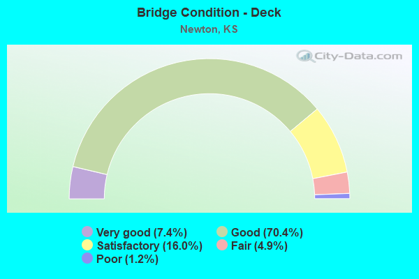
- Bridge Condition - Deck
- 7.4%Very good
- 70.4%Good
- 16.0%Satisfactory
- 4.9%Fair
- 1.2%Poor
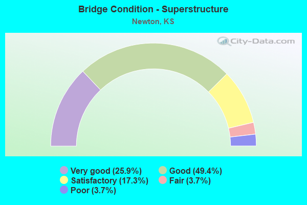
- Bridge Condition - Superstructure
- 25.9%Very good
- 49.4%Good
- 17.3%Satisfactory
- 3.7%Fair
- 3.7%Poor
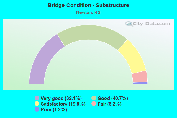
- Bridge Condition - Substructure
- 32.1%Very good
- 40.7%Good
- 19.8%Satisfactory
- 6.2%Fair
- 1.2%Poor
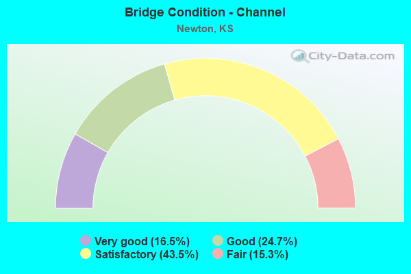
- Bridge Condition - Channel
- 16.5%Very good
- 24.7%Good
- 43.5%Satisfactory
- 15.3%Fair
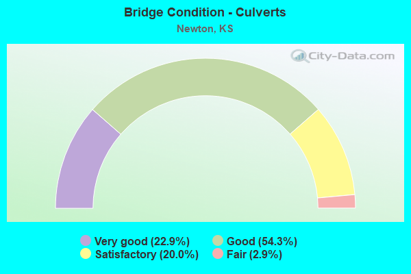
- Bridge Condition - Culverts
- 22.9%Very good
- 54.3%Good
- 20.0%Satisfactory
- 2.9%Fair
Find on map >> Show street view
Structure Number: 999905000400841, Location: 0.36 MI NE I135 JCT EB (Lat: 38.065556, Lng: -97.318333), Route carried "on" structure: US 50, Year Built: 1997, Status: Open, Structure Length: 4.95m (16.24ft), Average Daily Traffic: 3,183 (year 2020), Truck Traffic: 30%, Average Future Daily Traffic: 4,121 (year 2041), Design Load: HS 25 or greater, Features Intersected: SPENCER STREET
Minimum Vertical Clearance: 30.47m (99.97ft), Kilometerpoint: 37.301, Lanes on structure: 1, Lanes under structure: 2, Base Highway Network: Yes, Owner: State Highway Agency, Approaching Roadway Width: 8.5m (27.9ft), Material/Design: Concrete continuous, Design/Construction: Slab, Number Of Spans In Main Unit: 3, Length of Maximum Span: 19.5m (64.0ft), Curb-To-Curb Width: 8.5m (27.9ft), Out-to-Out Width: 9.1m (29.9ft)
Condition: Deck: Good, Superstructure: Very good, Substructure: Very good, Operating Rating: 90.6 metric tons, Method Used To Determine Operating Rating: Load Factor (LF), Inventory Rating: 54.4 metric tons, Method Used To Determine Inventory Rating: Load Factor (LF), Structural Evaluation: Equal to present desirable criteria, Deck Geometry: Meets minimum limits, Underclear: Somewhat better than minimum adequacy, Approach Roadway Alignment: Better than present minimum criteria, Length Of Structure Improvement: 16.25m (53.31ft), Designated Inspection Frequency: Every 24 months, Inspection Date: October 2020, Wearing Surface/Protective System: Wearing Surface: Monolithic Concrete, Deck Protection: Epoxy Coated Reinforcing
Find on map >> Show street view
Structure Number: 999905000400851, Location: 0.37 MI NE I135 JCT (Lat: 38.066389, Lng: -97.318333), Route carried "on" structure: US 50, Year Built: 1997, Status: Open, Structure Length: 4.34m (14.24ft), Average Daily Traffic: 3,183 (year 2020), Truck Traffic: 30%, Average Future Daily Traffic: 4,121 (year 2041), Design Load: HS 25 or greater, Features Intersected: SPENCER STREET
Minimum Vertical Clearance: 30.47m (99.97ft), Kilometerpoint: 37.464, Lanes on structure: 1, Lanes under structure: 2, Base Highway Network: Yes, Owner: State Highway Agency, Approaching Roadway Width: 8.5m (27.9ft), Material/Design: Concrete continuous, Design/Construction: Slab, Number Of Spans In Main Unit: 3, Length of Maximum Span: 17.1m (56.1ft), Curb-To-Curb Width: 8.5m (27.9ft), Out-to-Out Width: 9.1m (29.9ft)
Condition: Deck: Good, Superstructure: Very good, Substructure: Very good, Operating Rating: 88.0 metric tons, Method Used To Determine Operating Rating: Load Factor (LF), Inventory Rating: 52.6 metric tons, Method Used To Determine Inventory Rating: Load Factor (LF), Structural Evaluation: Equal to present desirable criteria, Deck Geometry: Meets minimum limits, Underclear: Somewhat better than minimum adequacy, Approach Roadway Alignment: Better than present minimum criteria, Length Of Structure Improvement: 14.25m (46.75ft), Designated Inspection Frequency: Every 24 months, Inspection Date: October 2020, Wearing Surface/Protective System: Wearing Surface: Monolithic Concrete, Deck Protection: Epoxy Coated Reinforcing
Find on map >> Show street view
Structure Number: 999905000400861, Location: 0.64 MI NE I135 -135 SL (Lat: 38.066389, Lng: -97.313333), Route carried "on" structure: US 50, Year Built: 1997, Status: Open, Structure Length: 4.98m (16.34ft), Average Daily Traffic: 3,183 (year 2020), Truck Traffic: 30%, Average Future Daily Traffic: 4,121 (year 2041), Design Load: HS 25 or greater, Features Intersected: RP FROM WB 50 TO SB CR
Minimum Vertical Clearance: 30.47m (99.97ft), Kilometerpoint: 37.749, Lanes on structure: 1, Lanes under structure: 1, Base Highway Network: Yes, Owner: State Highway Agency, Approaching Roadway Width: 8.5m (27.9ft), Skew: 4 degrees, Material/Design: Concrete continuous, Design/Construction: Slab, Number Of Spans In Main Unit: 3, Length of Maximum Span: 19.5m (64.0ft), Curb-To-Curb Width: 8.5m (27.9ft), Out-to-Out Width: 9.1m (29.9ft)
Condition: Deck: Good, Superstructure: Very good, Substructure: Very good, Operating Rating: 90.6 metric tons, Method Used To Determine Operating Rating: Load Factor (LF), Inventory Rating: 58.1 metric tons, Method Used To Determine Inventory Rating: Load Factor (LF), Structural Evaluation: Equal to present desirable criteria, Deck Geometry: Meets minimum limits, Underclear: Equal to present minimum criteria, Approach Roadway Alignment: Better than present minimum criteria, Length Of Structure Improvement: 16.33m (53.58ft), Designated Inspection Frequency: Every 24 months, Inspection Date: October 2020, Wearing Surface/Protective System: Wearing Surface: Monolithic Concrete, Deck Protection: Epoxy Coated Reinforcing
Find on map >> Show street view
Structure Number: 999905000400891, Location: .24 MI N SJCT K15, WL (Lat: 38.027500, Lng: -97.329444), Route carried "on" structure: US 50, Year Built: 2002, Status: Open, Structure Length: 5.60m (18.37ft), Average Daily Traffic: 3,000 (year 2020), Truck Traffic: 19%, Average Future Daily Traffic: 3,884 (year 2041), Design Load: HS 25 or greater, Features Intersected: I-135 SOUTHBOUND
Minimum Vertical Clearance: 30.47m (99.97ft), Kilometerpoint: 32.755, Lanes on structure: 1, Lanes under structure: 2, Base Highway Network: Yes, Owner: State Highway Agency, Approaching Roadway Width: 12.2m (40.0ft), Skew: 4 degrees, Material/Design: Concrete continuous, Design/Construction: Slab, Number Of Spans In Main Unit: 3, Length of Maximum Span: 22.0m (72.2ft), Curb-To-Curb Width: 9.1m (29.9ft), Out-to-Out Width: 9.9m (32.5ft)
Condition: Deck: Good, Superstructure: Very good, Substructure: Very good, Operating Rating: 90.6 metric tons, Method Used To Determine Operating Rating: Load Factor (LF), Inventory Rating: 57.2 metric tons, Method Used To Determine Inventory Rating: Load Factor (LF), Structural Evaluation: Equal to present desirable criteria, Deck Geometry: Meets minimum limits, Underclear: High priority of corrective action, Approach Roadway Alignment: Better than present minimum criteria, Length Of Structure Improvement: 18.38m (60.30ft), Designated Inspection Frequency: Every 24 months, Inspection Date: October 2020, Wearing Surface/Protective System: Wearing Surface: Monolithic Concrete, Deck Protection: Epoxy Coated Reinforcing
Find on map >> Show street view
Structure Number: 999905000401031, Location: 1.7 MI W K-15 W JCT (Lat: 38.026111, Lng: -97.354722), Route carried "on" structure: US 50, Year Built: 2013, Status: Open, Structure Length: 11.98m (39.30ft), Average Daily Traffic: 3,784 (year 2020), Truck Traffic: 19%, Average Future Daily Traffic: 4,899 (year 2041), Design Load: HL 93, Features Intersected: ANDERSON RNDBT & PD PASS
Minimum Vertical Clearance: 30.47m (99.97ft), Kilometerpoint: 30.504, Lanes on structure: 2, Lanes under structure: 2, Base Highway Network: Yes, Owner: State Highway Agency, Approaching Roadway Width: 12.2m (40.0ft), Material/Design: Steel continuous, Design/Construction: Stringer/Multi-beam, Number Of Spans In Main Unit: 3, Length of Maximum Span: 45.7m (149.9ft), Curb-To-Curb Width: 12.2m (40.0ft), Out-to-Out Width: 13.0m (42.7ft)
Condition: Deck: Good, Superstructure: Very good, Substructure: Very good, Operating Rating: 88.8 metric tons, Method Used To Determine Operating Rating: Load and Resistance Factor Rating (LRFR) rating reported by rating factor(RF) method using HL-93 loadings, Inventory Rating: 68.7 metric tons, Method Used To Determine Inventory Rating: Load and Resistance Factor Rating (LRFR) rating reported by rating factor(RF) method using HL-93 loadings, Structural Evaluation: Equal to present desirable criteria, Deck Geometry: Better than present minimum criteria, Underclear: Superior to present desirable criteria, Approach Roadway Alignment: Equal to present desirable criteria, Length Of Structure Improvement: 39.30m (128.94ft), Designated Inspection Frequency: Every 24 months, Inspection Date: October 2020, Wearing Surface/Protective System: Wearing Surface: Monolithic Concrete, Deck Protection: Epoxy Coated Reinforcing
Find on map >> Show street view
Structure Number: 999905000401041, Location: 1.7 MI W K-15 W JCT (Lat: 38.026389, Lng: -97.354722), Route carried "on" structure: US 50, Year Built: 2013, Status: Open, Structure Length: 11.98m (39.30ft), Average Daily Traffic: 3,784 (year 2020), Truck Traffic: 19%, Average Future Daily Traffic: 4,899 (year 2041), Design Load: HL 93, Features Intersected: ANDERSON RNDBT & PD PASS
Minimum Vertical Clearance: 30.47m (99.97ft), Kilometerpoint: 30.507, Lanes on structure: 2, Lanes under structure: 2, Base Highway Network: Yes, Owner: State Highway Agency, Approaching Roadway Width: 12.2m (40.0ft), Material/Design: Steel continuous, Design/Construction: Stringer/Multi-beam, Number Of Spans In Main Unit: 3, Length of Maximum Span: 45.7m (149.9ft), Curb-To-Curb Width: 12.2m (40.0ft), Out-to-Out Width: 13.0m (42.7ft)
Condition: Deck: Good, Superstructure: Very good, Substructure: Very good, Operating Rating: 88.8 metric tons, Method Used To Determine Operating Rating: Load and Resistance Factor Rating (LRFR) rating reported by rating factor(RF) method using HL-93 loadings, Inventory Rating: 68.7 metric tons, Method Used To Determine Inventory Rating: Load and Resistance Factor Rating (LRFR) rating reported by rating factor(RF) method using HL-93 loadings, Structural Evaluation: Equal to present desirable criteria, Deck Geometry: Better than present minimum criteria, Underclear: Superior to present desirable criteria, Approach Roadway Alignment: Equal to present desirable criteria, Length Of Structure Improvement: 39.30m (128.94ft), Designated Inspection Frequency: Every 24 months, Inspection Date: October 2020, Wearing Surface/Protective System: Wearing Surface: Monolithic Concrete, Deck Protection: Epoxy Coated Reinforcing
Find on map >> Show street view
Structure Number: 999905000401051, Location: 1.36 MI W K-15 W JCT (Lat: 38.026389, Lng: -97.360833), Route carried "on" structure: US 50, Year Built: 2012, Status: Open, Structure Length: 14.97m (49.11ft), Average Daily Traffic: 3,784 (year 2020), Truck Traffic: 19%, Average Future Daily Traffic: 4,899 (year 2041), Design Load: HL 93, Features Intersected: SAND CR & RR & PED PASS
Minimum Vertical Clearance: 30.47m (99.97ft), Kilometerpoint: 29.945, Lanes on structure: 2, Base Highway Network: Yes, Owner: State Highway Agency, Approaching Roadway Width: 15.8m (51.8ft), Skew: 3 degrees, Material/Design: Steel continuous, Design/Construction: Stringer/Multi-beam, Number Of Spans In Main Unit: 4, Length of Maximum Span: 41.2m (135.2ft), Curb-To-Curb Width: 15.8m (51.8ft), Out-to-Out Width: 16.5m (54.1ft)
Condition: Deck: Good, Superstructure: Very good, Substructure: Very good, Channel: Very good, Operating Rating: 49.9 metric tons, Method Used To Determine Operating Rating: Load and Resistance Factor Rating (LRFR) rating reported by rating factor(RF) method using HL-93 loadings, Inventory Rating: 38.2 metric tons, Method Used To Determine Inventory Rating: Load and Resistance Factor Rating (LRFR) rating reported by rating factor(RF) method using HL-93 loadings, Structural Evaluation: Equal to present desirable criteria, Deck Geometry: Superior to present desirable criteria, Waterway Adequacy: Equal to present desirable criteria, Approach Roadway Alignment: Equal to present desirable criteria, Length Of Structure Improvement: 56.70m (186.02ft), Designated Inspection Frequency: Every 24 months, Inspection Date: October 2020, Wearing Surface/Protective System: Wearing Surface: Monolithic Concrete, Deck Protection: Epoxy Coated Reinforcing
Find on map >> Show street view
Structure Number: 999905000401061, Location: 1.36 MI W K-15 W JCT (Lat: 38.026111, Lng: -97.361111), Route carried "on" structure: US 50, Year Built: 2014, Status: Open, Structure Length: 14.97m (49.11ft), Average Daily Traffic: 3,784 (year 2020), Truck Traffic: 19%, Average Future Daily Traffic: 4,899 (year 2041), Design Load: HL 93, Features Intersected: SAND CR & RR & PED PASS
Minimum Vertical Clearance: 30.47m (99.97ft), Kilometerpoint: 29.927, Lanes on structure: 2, Base Highway Network: Yes, Owner: State Highway Agency, Approaching Roadway Width: 12.2m (40.0ft), Skew: 3 degrees, Material/Design: Steel continuous, Design/Construction: Stringer/Multi-beam, Number Of Spans In Main Unit: 4, Length of Maximum Span: 41.2m (135.2ft), Curb-To-Curb Width: 12.2m (40.0ft), Out-to-Out Width: 12.8m (42.0ft)
Condition: Deck: Very good, Superstructure: Very good, Substructure: Very good, Channel: Very good, Operating Rating: 59.3 metric tons, Method Used To Determine Operating Rating: Load and Resistance Factor Rating (LRFR) rating reported by rating factor(RF) method using HL-93 loadings, Inventory Rating: 45.7 metric tons, Method Used To Determine Inventory Rating: Load and Resistance Factor Rating (LRFR) rating reported by rating factor(RF) method using HL-93 loadings, Structural Evaluation: Equal to present desirable criteria, Deck Geometry: Better than present minimum criteria, Waterway Adequacy: Equal to present desirable criteria, Approach Roadway Alignment: Equal to present desirable criteria, Length Of Structure Improvement: 49.10m (161.09ft), Designated Inspection Frequency: Every 24 months, Inspection Date: October 2020, Wearing Surface/Protective System: Wearing Surface: Monolithic Concrete, Deck Protection: Epoxy Coated Reinforcing
Find on map >> Show street view
Structure Number: 999913500400031, Location: 2.00 MI N OF SEDWICK CL (Lat: 37.941111, Lng: -97.328056), Route carried "on" structure: ServiceCounty highway 83, Year Built: 1969, Status: Open, Structure Length: 8.33m (27.33ft), Average Daily Traffic: 38 (year 2020), Average Future Daily Traffic: 16,716 (year 2041), Design Load: H 20, Features Intersected: I-135 HIGHWAY, Facility Carried by Structure: LOCAL ROAD
Minimum Vertical Clearance: 30.47m (99.97ft), Kilometerpoint: 8.979, Lanes on structure: 2, Lanes under structure: 4, Owner: State Highway Agency, Approaching Roadway Width: 8.5m (27.9ft), Material/Design: Steel continuous, Design/Construction: Stringer/Multi-beam, Number Of Spans In Main Unit: 4, Length of Maximum Span: 28.0m (91.9ft), Curb-To-Curb Width: 8.5m (27.9ft), Out-to-Out Width: 9.4m (30.8ft)
Condition: Deck: Good, Superstructure: Good, Substructure: Good, Operating Rating: 41.7 metric tons, Method Used To Determine Operating Rating: Load Factor (LF), Inventory Rating: 24.5 metric tons, Method Used To Determine Inventory Rating: Load Factor (LF), Structural Evaluation: Equal to present minimum criteria, Deck Geometry: Better than present minimum criteria, Underclear: Somewhat better than minimum adequacy, Approach Roadway Alignment: Somewhat better than minimum adequacy, Length Of Structure Improvement: 27.33m (89.67ft), Designated Inspection Frequency: Every 24 months, Inspection Date: October 2020, Deck Structure Type: Concrete Cast-file-Place, Wearing Surface/Protective System: Wearing Surface: Monolithic Concrete
Find on map >> Show street view
Structure Number: 999913500400041, Location: 2.09 MI N OF SEDWICK CL (Lat: 37.942222, Lng: -97.328056), Route carried "on" structure: Interstate 135, Year Built: 1970, Status: Open, Structure Length: 4.04m (13.25ft), Average Daily Traffic: 11,839 (year 2020), Truck Traffic: 19%, Average Future Daily Traffic: 16,915 (year 2041), Design Load: HS 20+Mod, Features Intersected: JESTER CREEK
Minimum Vertical Clearance: 30.47m (99.97ft), Kilometerpoint: 3.362, Lanes on structure: 2, Base Highway Network: Yes, Owner: State Highway Agency, Approaching Roadway Width: 12.2m (40.0ft), Material/Design: Concrete continuous, Design/Construction: Slab, Number Of Spans In Main Unit: 3, Length of Maximum Span: 15.8m (51.8ft), Curb-To-Curb Width: 12.2m (40.0ft), Out-to-Out Width: 12.8m (42.0ft)
Condition: Deck: Good, Superstructure: Good, Substructure: Very good, Channel: Good, Operating Rating: 63.5 metric tons, Method Used To Determine Operating Rating: Load Factor (LF), Inventory Rating: 38.1 metric tons, Method Used To Determine Inventory Rating: Load Factor (LF), Structural Evaluation: Better than present minimum criteria, Deck Geometry: Better than present minimum criteria, Waterway Adequacy: Better than present minimum criteria, Approach Roadway Alignment: Equal to present desirable criteria, Length Of Structure Improvement: 13.25m (43.47ft), Designated Inspection Frequency: Every 24 months, Inspection Date: October 2020, Deck Structure Type: Concrete Cast-file-Place, Wearing Surface/Protective System: Wearing Surface: Low Slump Concrete
Find on map >> Show street view
Structure Number: 999913500400051, Location: 2.08 MI N OF SEDWICK CL (Lat: 37.942222, Lng: -97.327778), Route carried "on" structure: Interstate 135, Year Built: 1970, Status: Open, Structure Length: 4.04m (13.25ft), Average Daily Traffic: 11,839 (year 2020), Truck Traffic: 19%, Average Future Daily Traffic: 16,915 (year 2041), Design Load: HS 20+Mod, Features Intersected: JESTER CREEK
Minimum Vertical Clearance: 30.47m (99.97ft), Kilometerpoint: 3.362, Lanes on structure: 2, Base Highway Network: Yes, Owner: State Highway Agency, Approaching Roadway Width: 12.2m (40.0ft), Material/Design: Concrete continuous, Design/Construction: Slab, Number Of Spans In Main Unit: 3, Length of Maximum Span: 15.8m (51.8ft), Curb-To-Curb Width: 12.2m (40.0ft), Out-to-Out Width: 12.8m (42.0ft)
Condition: Deck: Very good, Superstructure: Good, Substructure: Good, Channel: Good, Operating Rating: 63.5 metric tons, Method Used To Determine Operating Rating: Load Factor (LF), Inventory Rating: 38.1 metric tons, Method Used To Determine Inventory Rating: Load Factor (LF), Structural Evaluation: Better than present minimum criteria, Deck Geometry: Better than present minimum criteria, Waterway Adequacy: Better than present minimum criteria, Approach Roadway Alignment: Equal to present desirable criteria, Length Of Structure Improvement: 13.25m (43.47ft), Designated Inspection Frequency: Every 24 months, Inspection Date: October 2020, Deck Structure Type: Concrete Cast-file-Place, Wearing Surface/Protective System: Wearing Surface: Low Slump Concrete
Find on map >> Show street view
Structure Number: 999913500400061, Location: JCT K-196 (Lat: 37.955556, Lng: -97.327778), Route carried "on" structure: Interstate 135, Year Built: 1970, Status: Open, Structure Length: 7.15m (23.46ft), Average Daily Traffic: 11,839 (year 2020), Truck Traffic: 19%, Average Future Daily Traffic: 16,915 (year 2041), Design Load: HS 20+Mod, Features Intersected: RS1937 SPUR, K196
Minimum Vertical Clearance: 30.47m (99.97ft), Kilometerpoint: 4.839, Lanes on structure: 2, Lanes under structure: 4, Base Highway Network: Yes, Owner: State Highway Agency, Approaching Roadway Width: 12.2m (40.0ft), Material/Design: Concrete continuous, Design/Construction: Slab, Number Of Spans In Main Unit: 4, Length of Maximum Span: 20.1m (65.9ft), Curb-To-Curb Width: 12.2m (40.0ft), Out-to-Out Width: 12.8m (42.0ft)
Condition: Deck: Good, Superstructure: Good, Substructure: Very good, Operating Rating: 62.6 metric tons, Method Used To Determine Operating Rating: Load Factor (LF), Inventory Rating: 37.2 metric tons, Method Used To Determine Inventory Rating: Load Factor (LF), Structural Evaluation: Better than present minimum criteria, Deck Geometry: Better than present minimum criteria, Underclear: Better than present minimum criteria, Approach Roadway Alignment: Equal to present desirable criteria, Length Of Structure Improvement: 23.45m (76.94ft), Designated Inspection Frequency: Every 24 months, Inspection Date: October 2020, Deck Structure Type: Concrete Cast-file-Place, Wearing Surface/Protective System: Wearing Surface: Low Slump Concrete
Find on map >> Show street view
Structure Number: 999913500400071, Location: JCT K-196 (Lat: 37.955556, Lng: -97.327500), Route carried "on" structure: Interstate 135, Year Built: 1970, Status: Open, Structure Length: 7.15m (23.46ft), Average Daily Traffic: 11,839 (year 2020), Truck Traffic: 19%, Average Future Daily Traffic: 16,915 (year 2041), Design Load: HS 20+Mod, Features Intersected: RS1937 SPUR, K196
Minimum Vertical Clearance: 30.47m (99.97ft), Kilometerpoint: 4.841, Lanes on structure: 2, Lanes under structure: 4, Base Highway Network: Yes, Owner: State Highway Agency, Approaching Roadway Width: 12.2m (40.0ft), Material/Design: Concrete continuous, Design/Construction: Slab, Number Of Spans In Main Unit: 4, Length of Maximum Span: 20.1m (65.9ft), Curb-To-Curb Width: 12.2m (40.0ft), Out-to-Out Width: 12.8m (42.0ft)
Condition: Deck: Good, Superstructure: Good, Substructure: Good, Operating Rating: 62.6 metric tons, Method Used To Determine Operating Rating: Load Factor (LF), Inventory Rating: 37.2 metric tons, Method Used To Determine Inventory Rating: Load Factor (LF), Structural Evaluation: Better than present minimum criteria, Deck Geometry: Better than present minimum criteria, Underclear: Better than present minimum criteria, Approach Roadway Alignment: Equal to present desirable criteria, Length Of Structure Improvement: 23.45m (76.94ft), Designated Inspection Frequency: Every 24 months, Inspection Date: October 2020, Deck Structure Type: Concrete Cast-file-Place, Wearing Surface/Protective System: Wearing Surface: Low Slump Concrete
Find on map >> Show street view
Structure Number: 999913500400091, Location: 1.00 MI. N OF K-196 JCT (Lat: 37.970000, Lng: -97.326944), Route carried "on" structure: ServiceCounty highway 69, Year Built: 1969, Status: Open, Structure Length: 8.33m (27.33ft), Average Daily Traffic: 38 (year 2020), Average Future Daily Traffic: 17,074 (year 2041), Design Load: H 20, Features Intersected: I-135 HIGHWAY, Facility Carried by Structure: LOCAL ROAD
Minimum Vertical Clearance: 30.47m (99.97ft), Kilometerpoint: 10.503, Lanes on structure: 2, Lanes under structure: 4, Owner: State Highway Agency, Approaching Roadway Width: 7.3m (24.0ft), Material/Design: Steel continuous, Design/Construction: Stringer/Multi-beam, Number Of Spans In Main Unit: 4, Length of Maximum Span: 28.0m (91.9ft), Curb-To-Curb Width: 8.5m (27.9ft), Out-to-Out Width: 9.4m (30.8ft)
Condition: Deck: Good, Superstructure: Good, Substructure: Good, Operating Rating: 41.7 metric tons, Method Used To Determine Operating Rating: Load Factor (LF), Inventory Rating: 24.5 metric tons, Method Used To Determine Inventory Rating: Load Factor (LF), Structural Evaluation: Equal to present minimum criteria, Deck Geometry: Better than present minimum criteria, Underclear: Somewhat better than minimum adequacy, Approach Roadway Alignment: Somewhat better than minimum adequacy, Length Of Structure Improvement: 27.33m (89.67ft), Designated Inspection Frequency: Every 24 months, Inspection Date: October 2020, Deck Structure Type: Concrete Cast-file-Place, Wearing Surface/Protective System: Wearing Surface: Low Slump Concrete
Find on map >> Show street view
Structure Number: 999913500400101, Location: 1.61 MI. N OF K-196 JCT (Lat: 37.978889, Lng: -97.326667), Route carried "on" structure: Interstate 135, Year Built: 1970, Year Reconstructed: 1996, Status: Open, Structure Length: 1.47m (4.82ft), Average Daily Traffic: 12,092 (year 2020), Truck Traffic: 20%, Average Future Daily Traffic: 17,276 (year 2041), Design Load: H 20, Features Intersected: JESTER CREEK DRAINAGE
Minimum Vertical Clearance: 30.47m (99.97ft), Kilometerpoint: 7.427, Lanes on structure: 4, Base Highway Network: Yes, Owner: State Highway Agency, Approaching Roadway Width: 24.4m (80.1ft), Skew: 23 degrees, Material/Design: Concrete, Design/Construction: Culvert, Number Of Spans In Main Unit: 4, Length of Maximum Span: 3.0m (9.8ft), Curb-To-Curb Width: 24.4m (80.1ft), Out-to-Out Width: 61.0m (200.1ft)
Condition: Channel: Good, Culverts: Good, Operating Rating: 33.8 metric tons, Method Used To Determine Operating Rating: Load Factor (LF), Inventory Rating: 20.3 metric tons, Method Used To Determine Inventory Rating: Load Factor (LF), Structural Evaluation: Somewhat better than minimum adequacy, Deck Geometry: Superior to present desirable criteria, Waterway Adequacy: Equal to present minimum criteria, Approach Roadway Alignment: Equal to present desirable criteria, Length Of Structure Improvement: 4.83m (15.85ft), Designated Inspection Frequency: Every 24 months, Inspection Date: October 2020, Deck Structure Type: Concrete Cast-file-Place, Wearing Surface/Protective System: Wearing Surface: Monolithic Concrete
Find on map >> Show street view
Structure Number: 999913500400121, Location: 2.00 MI. N OF K-196 JCT (Lat: 37.984444, Lng: -97.326944), Route carried "on" structure: ServiceCounty highway 59, Year Built: 1970, Status: Open, Structure Length: 8.33m (27.33ft), Average Daily Traffic: 38 (year 2020), Average Future Daily Traffic: 17,074 (year 2041), Design Load: H 20, Features Intersected: I-135 HIGHWAY, Facility Carried by Structure: LOCAL ROAD
Minimum Vertical Clearance: 30.47m (99.97ft), Kilometerpoint: 15.318, Lanes on structure: 2, Lanes under structure: 4, Owner: State Highway Agency, Approaching Roadway Width: 8.5m (27.9ft), Material/Design: Steel continuous, Design/Construction: Stringer/Multi-beam, Number Of Spans In Main Unit: 4, Length of Maximum Span: 28.0m (91.9ft), Curb-To-Curb Width: 8.5m (27.9ft), Out-to-Out Width: 9.4m (30.8ft)
Condition: Deck: Good, Superstructure: Good, Substructure: Very good, Operating Rating: 41.7 metric tons, Method Used To Determine Operating Rating: Load Factor (LF), Inventory Rating: 24.5 metric tons, Method Used To Determine Inventory Rating: Load Factor (LF), Structural Evaluation: Equal to present minimum criteria, Deck Geometry: Better than present minimum criteria, Underclear: Somewhat better than minimum adequacy, Approach Roadway Alignment: Somewhat better than minimum adequacy, Length Of Structure Improvement: 27.33m (89.67ft), Designated Inspection Frequency: Every 24 months, Inspection Date: October 2020, Deck Structure Type: Concrete Cast-file-Place, Wearing Surface/Protective System: Wearing Surface: Monolithic Concrete
Find on map >> Show street view
Structure Number: 999913500400131, Location: 3.01 MI. N OF K-196 JCT (Lat: 37.999167, Lng: -97.328056), Route carried "on" structure: County highway 4130, Year Built: 1969, Status: Open, Structure Length: 8.33m (27.33ft), Average Daily Traffic: 2,775 (year 2020), Truck Traffic: 5%, Average Future Daily Traffic: 3,320 (year 2041), Design Load: H 20, Features Intersected: I-135 HIGHWAY, Facility Carried by Structure: SE 36th Street
Minimum Vertical Clearance: 30.47m (99.97ft), Kilometerpoint: 3.833, Lanes on structure: 2, Lanes under structure: 4, Owner: State Highway Agency, Approaching Roadway Width: 8.5m (27.9ft), Material/Design: Steel continuous, Design/Construction: Stringer/Multi-beam, Number Of Spans In Main Unit: 4, Length of Maximum Span: 28.0m (91.9ft), Curb-To-Curb Width: 8.5m (27.9ft), Out-to-Out Width: 9.4m (30.8ft)
Condition: Deck: Satisfactory, Superstructure: Good, Substructure: Good, Operating Rating: 41.7 metric tons, Method Used To Determine Operating Rating: Load Factor (LF), Inventory Rating: 24.5 metric tons, Method Used To Determine Inventory Rating: Load Factor (LF), Structural Evaluation: Equal to present minimum criteria, Deck Geometry: Meets minimum limits, Underclear: Somewhat better than minimum adequacy, Approach Roadway Alignment: Somewhat better than minimum adequacy, Length Of Structure Improvement: 27.33m (89.67ft), Designated Inspection Frequency: Every 24 months, Inspection Date: October 2020, Deck Structure Type: Concrete Cast-file-Place, Wearing Surface/Protective System: Wearing Surface: Bituminous
Find on map >> Show street view
Structure Number: 999913500400141, Location: 4.01 MI. N OF K-196 JCT (Lat: 38.013611, Lng: -97.327778), Route carried "on" structure: ServiceCity street 37, Year Built: 1970, Status: Open, Structure Length: 8.33m (27.33ft), Average Daily Traffic: 363 (year 2020), Truck Traffic: 1%, Average Future Daily Traffic: 17,145 (year 2041), Design Load: H 20, Features Intersected: I-135 HIGHWAY, Facility Carried by Structure: LOCAL ROAD
Minimum Vertical Clearance: 30.47m (99.97ft), Kilometerpoint: 0.847, Lanes on structure: 2, Lanes under structure: 4, Owner: State Highway Agency, Approaching Roadway Width: 7.3m (24.0ft), Material/Design: Steel continuous, Design/Construction: Stringer/Multi-beam, Number Of Spans In Main Unit: 4, Length of Maximum Span: 28.0m (91.9ft), Curb-To-Curb Width: 8.5m (27.9ft), Out-to-Out Width: 9.4m (30.8ft)
Condition: Deck: Good, Superstructure: Good, Substructure: Good, Operating Rating: 41.7 metric tons, Method Used To Determine Operating Rating: Load Factor (LF), Inventory Rating: 24.5 metric tons, Method Used To Determine Inventory Rating: Load Factor (LF), Structural Evaluation: Equal to present minimum criteria, Deck Geometry: Equal to present minimum criteria, Underclear: Somewhat better than minimum adequacy, Approach Roadway Alignment: Somewhat better than minimum adequacy, Length Of Structure Improvement: 27.33m (89.67ft), Designated Inspection Frequency: Every 24 months, Inspection Date: October 2020, Deck Structure Type: Concrete Cast-file-Place, Wearing Surface/Protective System: Wearing Surface: Epoxy Overlay
Find on map >> Show street view
Structure Number: 999913500400171, Location: 0.80 MI. N OF US-50 S JCT (Lat: 38.035000, Lng: -97.324167), Route carried "on" structure: Interstate 135, Year Built: 1959, Status: Open, Structure Length: 3.43m (11.25ft), Average Daily Traffic: 12,246 (year 2020), Truck Traffic: 18%, Average Future Daily Traffic: 18,924 (year 2041), Design Load: HS 20+Mod, Features Intersected: KO RAILROAD
Minimum Vertical Clearance: 30.47m (99.97ft), Kilometerpoint: 13.800, Lanes on structure: 2, Base Highway Network: Yes, Owner: State Highway Agency, Approaching Roadway Width: 12.2m (40.0ft), Material/Design: Concrete continuous, Design/Construction: Slab, Number Of Spans In Main Unit: 3, Length of Maximum Span: 13.4m (44.0ft), Curb-To-Curb Width: 12.2m (40.0ft), Out-to-Out Width: 12.8m (42.0ft)
Condition: Deck: Good, Superstructure: Good, Substructure: Good, Operating Rating: 46.3 metric tons, Method Used To Determine Operating Rating: Load Factor (LF), Inventory Rating: 28.1 metric tons, Method Used To Determine Inventory Rating: Load Factor (LF), Structural Evaluation: Better than present minimum criteria, Deck Geometry: Better than present minimum criteria, Underclear: Superior to present desirable criteria, Approach Roadway Alignment: Equal to present desirable criteria, Length Of Structure Improvement: 11.25m (36.91ft), Designated Inspection Frequency: Every 24 months, Inspection Date: October 2020, Deck Structure Type: Concrete Cast-file-Place, Wearing Surface/Protective System: Wearing Surface: Low Slump Concrete
Find on map >> Show street view
Structure Number: 999913500400181, Location: 0.79 MI. N OF US-50 S JCT (Lat: 38.034722, Lng: -97.324167), Route carried "on" structure: Interstate 135, Year Built: 1959, Status: Open, Structure Length: 3.43m (11.25ft), Average Daily Traffic: 12,246 (year 2020), Truck Traffic: 18%, Average Future Daily Traffic: 18,924 (year 2041), Design Load: HS 20+Mod, Features Intersected: KO RAILROAD
Minimum Vertical Clearance: 30.47m (99.97ft), Kilometerpoint: 13.707, Lanes on structure: 2, Base Highway Network: Yes, Owner: State Highway Agency, Approaching Roadway Width: 12.2m (40.0ft), Material/Design: Concrete continuous, Design/Construction: Slab, Number Of Spans In Main Unit: 3, Length of Maximum Span: 13.4m (44.0ft), Curb-To-Curb Width: 12.2m (40.0ft), Out-to-Out Width: 12.8m (42.0ft)
Condition: Deck: Good, Superstructure: Good, Substructure: Good, Operating Rating: 46.3 metric tons, Method Used To Determine Operating Rating: Load Factor (LF), Inventory Rating: 28.1 metric tons, Method Used To Determine Inventory Rating: Load Factor (LF), Structural Evaluation: Better than present minimum criteria, Deck Geometry: Better than present minimum criteria, Underclear: Equal to present minimum criteria, Approach Roadway Alignment: Equal to present desirable criteria, Length Of Structure Improvement: 11.25m (36.91ft), Designated Inspection Frequency: Every 24 months, Inspection Date: October 2020, Deck Structure Type: Concrete Cast-file-Place, Wearing Surface/Protective System: Wearing Surface: Low Slump Concrete
Find on map >> Show street view
Structure Number: 999913500400211, Location: 0.21 MI. S OF US-50 N JCT (Lat: 38.057222, Lng: -97.322500), Route carried "on" structure: Interstate 135, Year Built: 1959, Year Reconstructed: 2019, Status: Open, Structure Length: 3.12m (10.24ft), Average Daily Traffic: 10,749 (year 2020), Truck Traffic: 20%, Average Future Daily Traffic: 16,611 (year 2041), Design Load: HS 20+Mod, Features Intersected: 12TH ST
Minimum Vertical Clearance: 30.47m (99.97ft), Kilometerpoint: 16.291, Lanes on structure: 2, Lanes under structure: 2, Base Highway Network: Yes, Owner: State Highway Agency, Approaching Roadway Width: 12.2m (40.0ft), Material/Design: Concrete continuous, Design/Construction: Slab, Number Of Spans In Main Unit: 3, Length of Maximum Span: 12.2m (40.0ft), Curb-To-Curb Width: 11.9m (39.0ft), Out-to-Out Width: 12.8m (42.0ft)
Condition: Deck: Good, Superstructure: Good, Substructure: Good, Operating Rating: 39.9 metric tons, Method Used To Determine Operating Rating: Load Factor (LF), Inventory Rating: 23.6 metric tons, Method Used To Determine Inventory Rating: Load Factor (LF), Structural Evaluation: Somewhat better than minimum adequacy, Deck Geometry: Equal to present minimum criteria, Underclear: High priority of corrective action, Approach Roadway Alignment: Equal to present minimum criteria, Length Of Structure Improvement: 10.25m (33.63ft), Designated Inspection Frequency: Every 24 months, Inspection Date: October 2020, Deck Structure Type: Concrete Cast-file-Place, Wearing Surface/Protective System: Wearing Surface: Low Slump Concrete
Find on map >> Show street view
Structure Number: 999913500400231, Location: 0.03 MI. S OF US-50 N JCT (Lat: 38.059722, Lng: -97.322500), Route carried "on" structure: Interstate 135, Year Built: 1959, Year Reconstructed: 1984, Status: Open, Structure Length: 11.31m (37.11ft), Average Daily Traffic: 10,749 (year 2020), Truck Traffic: 20%, Average Future Daily Traffic: 16,611 (year 2041), Design Load: HS 20+Mod, Features Intersected: BNSF RR&OLD U50
Minimum Vertical Clearance: 30.47m (99.97ft), Kilometerpoint: 16.555, Lanes on structure: 3, Lanes under structure: 2, Base Highway Network: Yes, Owner: State Highway Agency, Approaching Roadway Width: 14.6m (47.9ft), Material/Design: Steel continuous, Design/Construction: Stringer/Multi-beam, Number Of Spans In Main Unit: 5, Length of Maximum Span: 24.4m (80.1ft), Curb-To-Curb Width: 14.6m (47.9ft), Out-to-Out Width: 15.4m (50.5ft)
Condition: Deck: Good, Superstructure: Good, Substructure: Good, Operating Rating: 74.8 metric tons, Method Used To Determine Operating Rating: Load Factor (LF), Inventory Rating: 44.8 metric tons, Method Used To Determine Inventory Rating: Load Factor (LF), Structural Evaluation: Better than present minimum criteria, Deck Geometry: Meets minimum limits, Underclear: Meets minimum limits, Approach Roadway Alignment: Equal to present desirable criteria, Length Of Structure Improvement: 37.10m (121.72ft), Designated Inspection Frequency: Every 24 months, Inspection Date: October 2020, Deck Structure Type: Concrete Cast-file-Place, Wearing Surface/Protective System: Wearing Surface: Epoxy Overlay
Find on map >> Show street view
Structure Number: 999913500400241, Location: 0.04 MI. S OF US-50 N JCT (Lat: 38.059722, Lng: -97.322222), Route carried "on" structure: Interstate 135, Year Built: 1956, Year Reconstructed: 1985, Status: Open, Structure Length: 11.31m (37.11ft), Average Daily Traffic: 10,749 (year 2020), Truck Traffic: 20%, Average Future Daily Traffic: 16,611 (year 2041), Design Load: HS 20+Mod, Features Intersected: BNSF RR&OLD U50
Minimum Vertical Clearance: 30.47m (99.97ft), Kilometerpoint: 16.485, Lanes on structure: 2, Lanes under structure: 2, Base Highway Network: Yes, Owner: State Highway Agency, Approaching Roadway Width: 12.2m (40.0ft), Material/Design: Steel continuous, Design/Construction: Stringer/Multi-beam, Number Of Spans In Main Unit: 5, Length of Maximum Span: 24.4m (80.1ft), Curb-To-Curb Width: 12.2m (40.0ft), Out-to-Out Width: 13.0m (42.7ft)
Condition: Deck: Good, Superstructure: Good, Substructure: Good, Operating Rating: 77.4 metric tons, Method Used To Determine Operating Rating: Load Factor (LF), Inventory Rating: 46.3 metric tons, Method Used To Determine Inventory Rating: Load Factor (LF), Structural Evaluation: Better than present minimum criteria, Deck Geometry: Better than present minimum criteria, Underclear: Equal to present desirable criteria, Approach Roadway Alignment: Equal to present desirable criteria, Length Of Structure Improvement: 37.10m (121.72ft), Designated Inspection Frequency: Every 24 months, Inspection Date: October 2020, Deck Structure Type: Concrete Cast-file-Place, Wearing Surface/Protective System: Wearing Surface: Low Slump Concrete
Find on map >> Show street view
Structure Number: 999913500400251, Location: 0.55 MI NW OF 50 N JCT (Lat: 38.067778, Lng: -97.323889), Route carried "on" structure: Interstate 135, Year Built: 1959, Year Reconstructed: 2000, Status: Open, Structure Length: 1.52m (4.99ft), Average Daily Traffic: 7,574 (year 2020), Truck Traffic: 28%, Average Future Daily Traffic: 11,704 (year 2041), Design Load: HS 20+Mod, Features Intersected: SAND CREEK DRAINAGE
Minimum Vertical Clearance: 30.47m (99.97ft), Kilometerpoint: 17.466, Lanes on structure: 4, Base Highway Network: Yes, Owner: State Highway Agency, Approaching Roadway Width: 24.4m (80.1ft), Skew: 20 degrees, Material/Design: Concrete, Design/Construction: Culvert, Number Of Spans In Main Unit: 4, Length of Maximum Span: 3.7m (12.1ft), Curb-To-Curb Width: 24.4m (80.1ft), Out-to-Out Width: 46.8m (153.5ft)
Condition: Channel: Satisfactory, Culverts: Good, Operating Rating: 47.2 metric tons, Method Used To Determine Operating Rating: Load Factor (LF), Inventory Rating: 28.2 metric tons, Method Used To Determine Inventory Rating: Load Factor (LF), Structural Evaluation: Better than present minimum criteria, Deck Geometry: Superior to present desirable criteria, Waterway Adequacy: Equal to present minimum criteria, Approach Roadway Alignment: Equal to present desirable criteria, Length Of Structure Improvement: 4.98m (16.34ft), Designated Inspection Frequency: Every 24 months, Inspection Date: October 2020, Deck Structure Type: Concrete Cast-file-Place, Wearing Surface/Protective System: Wearing Surface: Monolithic Concrete
Find on map >> Show street view
Structure Number: 999913500400261, Location: 0.88 MI NW OF 50 N JCT (Lat: 38.071667, Lng: -97.326944), Route carried "on" structure: ServiceCounty highway 38, Year Built: 1959, Status: Open, Structure Length: 8.98m (29.46ft), Average Daily Traffic: 363 (year 2020), Truck Traffic: 1%, Average Future Daily Traffic: 12,903 (year 2041), Design Load: H 15, Features Intersected: I-135 HIGHWAY, Facility Carried by Structure: 24TH STREET
Minimum Vertical Clearance: 30.47m (99.97ft), Kilometerpoint: 0.761, Lanes on structure: 2, Lanes under structure: 4, Owner: State Highway Agency, Approaching Roadway Width: 8.5m (27.9ft), Material/Design: Concrete continuous, Design/Construction: Box Beam or Girders - Multiple, Number Of Spans In Main Unit: 4, Length of Maximum Span: 24.7m (81.0ft), Curb-To-Curb Width: 7.3m (24.0ft), Out-to-Out Width: 7.8m (25.6ft)
Condition: Deck: Good, Superstructure: Good, Substructure: Good, Operating Rating: 55.7 metric tons, Method Used To Determine Operating Rating: Load Factor (LF), Inventory Rating: 33.3 metric tons, Method Used To Determine Inventory Rating: Load Factor (LF), Structural Evaluation: Better than present minimum criteria, Deck Geometry: Somewhat better than minimum adequacy, Underclear: Equal to present minimum criteria, Approach Roadway Alignment: Somewhat better than minimum adequacy, Length Of Structure Improvement: 29.45m (96.62ft), Designated Inspection Frequency: Every 24 months, Inspection Date: October 2020, Deck Structure Type: Concrete Cast-file-Place, Wearing Surface/Protective System: Wearing Surface: Low Slump Concrete
Find on map >> Show street view
Structure Number: 999913500400831, Location: 0.22 MI S OF US-50 N JCT (Lat: 38.057222, Lng: -97.322222), Route carried "on" structure: Interstate 135, Year Built: 1994, Status: Open, Structure Length: 3.12m (10.24ft), Average Daily Traffic: 10,749 (year 2020), Truck Traffic: 20%, Average Future Daily Traffic: 16,611 (year 2041), Design Load: HS 25 or greater, Features Intersected: 12TH ST.
Minimum Vertical Clearance: 30.47m (99.97ft), Kilometerpoint: 16.208, Lanes on structure: 2, Lanes under structure: 2, Base Highway Network: Yes, Owner: State Highway Agency, Approaching Roadway Width: 12.2m (40.0ft), Material/Design: Concrete continuous, Design/Construction: Slab, Number Of Spans In Main Unit: 3, Length of Maximum Span: 12.2m (40.0ft), Curb-To-Curb Width: 12.2m (40.0ft), Out-to-Out Width: 13.0m (42.7ft)
Condition: Deck: Good, Superstructure: Very good, Substructure: Very good, Operating Rating: 79.8 metric tons, Method Used To Determine Operating Rating: Load Factor (LF), Inventory Rating: 48.1 metric tons, Method Used To Determine Inventory Rating: Load Factor (LF), Structural Evaluation: Equal to present desirable criteria, Deck Geometry: Better than present minimum criteria, Underclear: Meets minimum limits, Approach Roadway Alignment: Equal to present desirable criteria, Length Of Structure Improvement: 10.25m (33.63ft), Designated Inspection Frequency: Every 24 months, Inspection Date: October 2020, Wearing Surface/Protective System: Wearing Surface: Monolithic Concrete, Deck Protection: Epoxy Coated Reinforcing
Find on map >> Show street view
Structure Number: 999913500400901, Location: 1.33 MI. N OF US-50 S JCT (Lat: 38.042500, Lng: -97.322222), Route carried "on" structure: Interstate 135, Year Built: 2002, Status: Open, Structure Length: 10.09m (33.10ft), Average Daily Traffic: 11,520 (year 2020), Truck Traffic: 20%, Average Future Daily Traffic: 17,802 (year 2041), Design Load: HS 25 or greater, Features Intersected: N. 1ST ST
Minimum Vertical Clearance: 30.47m (99.97ft), Kilometerpoint: 14.566, Lanes on structure: 2, Lanes under structure: 2, Base Highway Network: Yes, Owner: State Highway Agency, Approaching Roadway Width: 12.2m (40.0ft), Material/Design: Steel continuous, Design/Construction: Stringer/Multi-beam, Number Of Spans In Main Unit: 4, Length of Maximum Span: 31.0m (101.7ft), Curb-To-Curb Width: 12.2m (40.0ft), Out-to-Out Width: 12.9m (42.3ft)
Condition: Deck: Good, Superstructure: Very good, Substructure: Very good, Inventory Rating: 60.8 metric tons, Method Used To Determine Inventory Rating: Load Factor (LF), Structural Evaluation: Equal to present desirable criteria, Deck Geometry: Better than present minimum criteria, Underclear: Superior to present desirable criteria, Approach Roadway Alignment: Equal to present desirable criteria, Length Of Structure Improvement: 33.10m (108.60ft), Designated Inspection Frequency: Every 24 months, Inspection Date: October 2020, Wearing Surface/Protective System: Wearing Surface: Low Slump Concrete, Deck Protection: Epoxy Coated Reinforcing
Find on map >> Show street view
Structure Number: 999913500400911, Location: 1.33 MI. N OF US-50 JCT. (Lat: 38.042500, Lng: -97.322500), Route carried "on" structure: Interstate 135, Year Built: 2000, Status: Open, Structure Length: 10.09m (33.10ft), Average Daily Traffic: 11,520 (year 2020), Truck Traffic: 20%, Average Future Daily Traffic: 17,802 (year 2041), Design Load: HS 25 or greater, Features Intersected: N. 1ST ST.
Minimum Vertical Clearance: 30.47m (99.97ft), Kilometerpoint: 14.650, Lanes on structure: 2, Lanes under structure: 2, Base Highway Network: Yes, Owner: State Highway Agency, Approaching Roadway Width: 12.2m (40.0ft), Material/Design: Steel continuous, Design/Construction: Stringer/Multi-beam, Number Of Spans In Main Unit: 4, Length of Maximum Span: 31.0m (101.7ft), Curb-To-Curb Width: 12.2m (40.0ft), Out-to-Out Width: 12.9m (42.3ft)
Condition: Deck: Good, Superstructure: Very good, Substructure: Good, Inventory Rating: 60.8 metric tons, Method Used To Determine Inventory Rating: Load Factor (LF), Structural Evaluation: Better than present minimum criteria, Deck Geometry: Better than present minimum criteria, Underclear: Better than present minimum criteria, Approach Roadway Alignment: Equal to present desirable criteria, Length Of Structure Improvement: 33.10m (108.60ft), Designated Inspection Frequency: Every 24 months, Inspection Date: October 2020, Wearing Surface/Protective System: Wearing Surface: Low Slump Concrete, Deck Protection: Epoxy Coated Reinforcing
Find on map >> Show street view
Structure Number: 999913500400921, Location: .82 MI. S OF US-50 N JCT (Lat: 38.050000, Lng: -97.322222), Route carried "on" structure: Interstate 135, Year Built: 2002, Status: Open, Structure Length: 10.09m (33.10ft), Average Daily Traffic: 11,520 (year 2020), Truck Traffic: 20%, Average Future Daily Traffic: 17,802 (year 2041), Design Load: HS 25 or greater, Features Intersected: BROADWAY
Minimum Vertical Clearance: 30.47m (99.97ft), Kilometerpoint: 15.403, Lanes on structure: 2, Lanes under structure: 2, Base Highway Network: Yes, Owner: State Highway Agency, Approaching Roadway Width: 12.2m (40.0ft), Material/Design: Steel continuous, Design/Construction: Stringer/Multi-beam, Number Of Spans In Main Unit: 4, Length of Maximum Span: 31.0m (101.7ft), Curb-To-Curb Width: 12.2m (40.0ft), Out-to-Out Width: 12.9m (42.3ft)
Condition: Deck: Good, Superstructure: Very good, Substructure: Very good, Inventory Rating: 60.8 metric tons, Method Used To Determine Inventory Rating: Load Factor (LF), Structural Evaluation: Equal to present desirable criteria, Deck Geometry: Better than present minimum criteria, Underclear: Better than present minimum criteria, Approach Roadway Alignment: Equal to present desirable criteria, Length Of Structure Improvement: 33.10m (108.60ft), Designated Inspection Frequency: Every 24 months, Inspection Date: October 2020, Wearing Surface/Protective System: Wearing Surface: Low Slump Concrete, Deck Protection: Epoxy Coated Reinforcing
Find on map >> Show street view
Structure Number: 999913500400931, Location: .82 MI. S OF US-50 N JCT. (Lat: 38.050000, Lng: -97.322500), Route carried "on" structure: Interstate 135, Year Built: 2002, Status: Open, Structure Length: 10.09m (33.10ft), Average Daily Traffic: 11,520 (year 2020), Truck Traffic: 20%, Average Future Daily Traffic: 17,802 (year 2041), Design Load: HS 25 or greater, Features Intersected: BROADWAY
Minimum Vertical Clearance: 30.47m (99.97ft), Kilometerpoint: 15.485, Lanes on structure: 2, Lanes under structure: 2, Base Highway Network: Yes, Owner: State Highway Agency, Approaching Roadway Width: 12.2m (40.0ft), Material/Design: Steel continuous, Design/Construction: Stringer/Multi-beam, Number Of Spans In Main Unit: 4, Length of Maximum Span: 31.0m (101.7ft), Curb-To-Curb Width: 12.2m (40.0ft), Out-to-Out Width: 12.9m (42.3ft)
Condition: Deck: Good, Superstructure: Very good, Substructure: Good, Inventory Rating: 60.8 metric tons, Method Used To Determine Inventory Rating: Load Factor (LF), Structural Evaluation: Better than present minimum criteria, Deck Geometry: Better than present minimum criteria, Underclear: Better than present minimum criteria, Approach Roadway Alignment: Equal to present desirable criteria, Length Of Structure Improvement: 33.10m (108.60ft), Designated Inspection Frequency: Every 24 months, Inspection Date: October 2020, Wearing Surface/Protective System: Wearing Surface: Low Slump Concrete, Deck Protection: Epoxy Coated Reinforcing
Find on map >> Show street view
Structure Number: 999913500400981, Location: 1.58 MI N OF US-50 S JCT (Lat: 38.049167, Lng: -97.322500), Route carried "on" structure: Interstate 135, Year Built: 2002, Status: Open, Structure Length: 1.02m (3.35ft), Average Daily Traffic: 11,520 (year 2020), Truck Traffic: 20%, Average Future Daily Traffic: 17,802 (year 2041), Design Load: HS 20, Features Intersected: SAND CREEK DRAINAGE
Minimum Vertical Clearance: 30.47m (99.97ft), Kilometerpoint: 15.371, Lanes on structure: 6, Base Highway Network: Yes, Owner: State Highway Agency, Approaching Roadway Width: 39.6m (129.9ft), Skew: 20 degrees, Material/Design: Concrete, Design/Construction: Culvert, Number Of Spans In Main Unit: 3, Length of Maximum Span: 3.0m (9.8ft), Curb-To-Curb Width: 39.6m (129.9ft), Out-to-Out Width: 102.0m (334.6ft)
Condition: Channel: Good, Culverts: Good, Operating Rating: 89.8 metric tons, Method Used To Determine Operating Rating: Load Factor (LF), Inventory Rating: 89.8 metric tons, Method Used To Determine Inventory Rating: Load Factor (LF), Structural Evaluation: Better than present minimum criteria, Deck Geometry: Superior to present desirable criteria, Waterway Adequacy: Equal to present desirable criteria, Approach Roadway Alignment: Equal to present desirable criteria, Length Of Structure Improvement: 3.36m (11.02ft), Designated Inspection Frequency: Every 24 months, Inspection Date: October 2020, Deck Structure Type: Concrete Cast-file-Place, Wearing Surface/Protective System: Wearing Surface: Monolithic Concrete
Find on map >> Show street view
Structure Number: 999913500400991, Location: .69 MI. N. OF US-50 JCT. (Lat: 38.033611, Lng: -97.325000), Route carried "on" structure: Interstate 135, Year Built: 2002, Status: Open, Structure Length: 4.59m (15.06ft), Average Daily Traffic: 12,246 (year 2020), Truck Traffic: 18%, Average Future Daily Traffic: 18,924 (year 2041), Design Load: HS 25 or greater, Features Intersected: SE 14TH ST.
Minimum Vertical Clearance: 30.47m (99.97ft), Kilometerpoint: 13.642, Lanes on structure: 2, Lanes under structure: 2, Base Highway Network: Yes, Owner: State Highway Agency, Approaching Roadway Width: 12.2m (40.0ft), Skew: 2 degrees, Material/Design: Concrete continuous, Design/Construction: Slab, Number Of Spans In Main Unit: 3, Length of Maximum Span: 18.0m (59.1ft), Curb-To-Curb Width: 12.2m (40.0ft), Out-to-Out Width: 14.9m (48.9ft)
Condition: Deck: Good, Superstructure: Very good, Substructure: Very good, Operating Rating: 90.6 metric tons, Method Used To Determine Operating Rating: Load Factor (LF), Inventory Rating: 55.3 metric tons, Method Used To Determine Inventory Rating: Load Factor (LF), Structural Evaluation: Equal to present desirable criteria, Deck Geometry: Better than present minimum criteria, Underclear: Equal to present desirable criteria, Approach Roadway Alignment: Equal to present desirable criteria, Length Of Structure Improvement: 15.05m (49.38ft), Designated Inspection Frequency: Every 24 months, Inspection Date: October 2020, Wearing Surface/Protective System: Wearing Surface: Monolithic Concrete, Deck Protection: Epoxy Coated Reinforcing
Find on map >> Show street view
Structure Number: 999913500401001, Location: .69 MI. N OF US-50 JCT (Lat: 38.033611, Lng: -97.324722), Route carried "on" structure: Interstate 135, Year Built: 2002, Status: Open, Structure Length: 4.59m (15.06ft), Average Daily Traffic: 12,246 (year 2020), Truck Traffic: 18%, Average Future Daily Traffic: 18,924 (year 2041), Design Load: HS 25 or greater, Features Intersected: SE 14TH ST
Minimum Vertical Clearance: 30.47m (99.97ft), Kilometerpoint: 13.556, Lanes on structure: 2, Lanes under structure: 2, Base Highway Network: Yes, Owner: State Highway Agency, Approaching Roadway Width: 12.2m (40.0ft), Skew: 2 degrees, Material/Design: Concrete continuous, Design/Construction: Slab, Number Of Spans In Main Unit: 3, Length of Maximum Span: 18.0m (59.1ft), Curb-To-Curb Width: 12.2m (40.0ft), Out-to-Out Width: 14.8m (48.6ft)
Condition: Deck: Very good, Superstructure: Very good, Substructure: Very good, Operating Rating: 90.6 metric tons, Method Used To Determine Operating Rating: Load Factor (LF), Inventory Rating: 55.3 metric tons, Method Used To Determine Inventory Rating: Load Factor (LF), Structural Evaluation: Equal to present desirable criteria, Deck Geometry: Better than present minimum criteria, Underclear: Equal to present desirable criteria, Approach Roadway Alignment: Equal to present desirable criteria, Length Of Structure Improvement: 15.05m (49.38ft), Designated Inspection Frequency: Every 24 months, Inspection Date: October 2020, Wearing Surface/Protective System: Wearing Surface: Monolithic Concrete, Deck Protection: Epoxy Coated Reinforcing
Find on map >> Show street view
Structure Number: 999919600400761, Location: 0.38 MI E I135 (Lat: 37.955556, Lng: -97.320556), Route carried "on" structure: State highway 196, Year Built: 1987, Status: Open, Structure Length: 4.35m (14.27ft), Average Daily Traffic: 2,337 (year 2020), Truck Traffic: 13%, Average Future Daily Traffic: 2,582 (year 2041), Design Load: HS 20, Features Intersected: JESTER CREEK
Minimum Vertical Clearance: 30.47m (99.97ft), Kilometerpoint: 0.813, Lanes on structure: 2, Base Highway Network: Yes, Owner: State Highway Agency, Approaching Roadway Width: 12.2m (40.0ft), Material/Design: Concrete continuous, Design/Construction: Slab, Number Of Spans In Main Unit: 3, Length of Maximum Span: 17.1m (56.1ft), Curb-To-Curb Width: 12.2m (40.0ft), Out-to-Out Width: 12.8m (42.0ft)
Condition: Deck: Very good, Superstructure: Very good, Substructure: Good, Channel: Satisfactory, Operating Rating: 78.9 metric tons, Method Used To Determine Operating Rating: Load Factor (LF), Inventory Rating: 47.2 metric tons, Method Used To Determine Inventory Rating: Load Factor (LF), Structural Evaluation: Better than present minimum criteria, Deck Geometry: Equal to present minimum criteria, Waterway Adequacy: Equal to present minimum criteria, Approach Roadway Alignment: Somewhat better than minimum adequacy, Length Of Structure Improvement: 14.26m (46.78ft), Designated Inspection Frequency: Every 24 months, Inspection Date: October 2020, Wearing Surface/Protective System: Wearing Surface: Low Slump Concrete, Deck Protection: Epoxy Coated Reinforcing
Find on map >> Show street view
Structure Number: 999901500400621, Location: US-50/I-135 JCT. (Lat: 38.026667, Lng: -97.329722), Route carried "under" structure: US 50, Year Built: 1970, Structure Length: 0. m, Average Daily Traffic: 9,434 (year 2020), Truck Traffic: 21%, Features Intersected: I-135 HWY SB, US-50 EB, Facility Carried by Structure: I-135NB to K15NB
Minimum Vertical Clearance: 7.62m (25.00ft), Kilometerpoint: 32.637, Lanes on structure: 1, Lanes under structure: 2, Material/Design: Steel continuous, Design/Construction: Stringer/Multi-beam, Length of Maximum Span: 28.0m (91.9ft)
Find on map >> Show street view
Structure Number: 999901500400621, Location: US-50/I-135 JCT. (Lat: 38.026667, Lng: -97.329722), Route carried "under" structure: US 50, Year Built: 1970, Structure Length: 0. m, Average Daily Traffic: 9,434 (year 2020), Truck Traffic: 21%, Features Intersected: I-135 HWY SB, US-50 EB, Facility Carried by Structure: I-135NB to K15NB
Minimum Vertical Clearance: 4.91m (16.11ft), Kilometerpoint: 32.637, Lanes on structure: 1, Lanes under structure: 1, Material/Design: Steel continuous, Design/Construction: Stringer/Multi-beam, Length of Maximum Span: 28.0m (91.9ft)
Find on map >> Show street view
Structure Number: 999905000400581, Location: US-50/I-135 N. JCT. (Lat: 38.065278, Lng: -97.322500), Route carried "under" structure: Interstate 135, Year Built: 1959, Structure Length: 0. m, Average Daily Traffic: 7,574 (year 2020), Truck Traffic: 28%, Features Intersected: I135 HWY NB-SB, Facility Carried by Structure: US-50 WESTBOUND
Minimum Vertical Clearance: 5.23m (17.16ft), Kilometerpoint: 17.183, Lanes on structure: 1, Lanes under structure: 4, Material/Design: Concrete continuous, Design/Construction: Box Beam or Girders - Multiple, Length of Maximum Span: 22.9m (75.1ft)
Find on map >> Show street view
Structure Number: 999905000400741, Location: JCT U50 / K15 (Lat: 38.026111, Lng: -97.336389), Route carried "under" structure: US 50, Year Built: 1975, Structure Length: 0. m, Average Daily Traffic: 4,929 (year 2020), Truck Traffic: 15%, Features Intersected: URB4123, K15 HWY
Minimum Vertical Clearance: 5.17m (16.96ft), Kilometerpoint: 32.116, Lanes on structure: 2, Lanes under structure: 4, Material/Design: Steel continuous, Design/Construction: Stringer/Multi-beam, Length of Maximum Span: 20.1m (65.9ft)
Find on map >> Show street view
Structure Number: 999905000400891, Location: .24 MI N SJCT K15, WL (Lat: 38.027500, Lng: -97.329444), Route carried "under" structure: Interstate 135, Year Built: 2002, Structure Length: 0. m, Average Daily Traffic: 9,434 (year 2020), Truck Traffic: 21%, Features Intersected: I-135 SOUTHBOUND, Facility Carried by Structure: US 50 EASTBOUND
Minimum Vertical Clearance: 5.51m (18.08ft), Kilometerpoint: 12.835, Lanes on structure: 1, Lanes under structure: 2, Material/Design: Concrete continuous, Design/Construction: Slab, Length of Maximum Span: 22.0m (72.2ft)
Find on map >> Show street view
Structure Number: 999913500400031, Location: 2.00 MI N OF SEDWICK CL (Lat: 37.941111, Lng: -97.328056), Route carried "under" structure: Interstate 135, Year Built: 1969, Structure Length: 0. m, Average Daily Traffic: 11,839 (year 2020), Truck Traffic: 19%, Features Intersected: I-135 HIGHWAY, Facility Carried by Structure: LOCAL ROAD
Minimum Vertical Clearance: 4.95m (16.24ft), Kilometerpoint: 3.227, Lanes on structure: 2, Lanes under structure: 4, Material/Design: Steel continuous, Design/Construction: Stringer/Multi-beam, Length of Maximum Span: 28.0m (91.9ft)
Find on map >> Show street view
Structure Number: 999913500400061, Location: JCT K-196 (Lat: 37.955556, Lng: -97.327778), Route carried "under" structure: State highway 196, Year Built: 1970, Structure Length: 0. m, Average Daily Traffic: 2,337 (year 2020), Truck Traffic: 13%, Features Intersected: RS1937 SPUR, K196, Facility Carried by Structure: I-135 SOUTHBOUND
Minimum Vertical Clearance: 4.95m (16.24ft), Kilometerpoint: 0.097, Lanes on structure: 2, Lanes under structure: 4, Material/Design: Concrete continuous, Design/Construction: Slab, Length of Maximum Span: 20.1m (65.9ft)
Find on map >> Show street view
Structure Number: 999913500400071, Location: JCT K-196 (Lat: 37.955556, Lng: -97.327500), Route carried "under" structure: State highway 196, Year Built: 1970, Structure Length: 0. m, Average Daily Traffic: 2,337 (year 2020), Truck Traffic: 13%, Features Intersected: RS1937 SPUR, K196, Facility Carried by Structure: I-135 NORTHBOUND
Minimum Vertical Clearance: 4.93m (16.17ft), Kilometerpoint: 0.122, Lanes on structure: 2, Lanes under structure: 4, Material/Design: Concrete continuous, Design/Construction: Slab, Length of Maximum Span: 20.1m (65.9ft)
Find on map >> Show street view
Structure Number: 999913500400091, Location: 1.00 MI. N OF K-196 JCT (Lat: 37.970000, Lng: -97.326944), Route carried "under" structure: Interstate 135, Year Built: 1969, Structure Length: 0. m, Average Daily Traffic: 12,092 (year 2020), Truck Traffic: 20%, Features Intersected: I-135 HIGHWAY, Facility Carried by Structure: LOCAL ROAD
Minimum Vertical Clearance: 4.90m (16.08ft), Kilometerpoint: 6.445, Lanes on structure: 2, Lanes under structure: 4, Material/Design: Steel continuous, Design/Construction: Stringer/Multi-beam, Length of Maximum Span: 28.0m (91.9ft)
Find on map >> Show street view
Structure Number: 999913500400121, Location: 2.00 MI. N OF K-196 JCT (Lat: 37.984444, Lng: -97.326944), Route carried "under" structure: Interstate 135, Year Built: 1970, Structure Length: 0. m, Average Daily Traffic: 12,092 (year 2020), Truck Traffic: 20%, Features Intersected: I-135 HIGHWAY, Facility Carried by Structure: LOCAL ROAD
Minimum Vertical Clearance: 4.92m (16.14ft), Kilometerpoint: 8.048, Lanes on structure: 2, Lanes under structure: 4, Material/Design: Steel continuous, Design/Construction: Stringer/Multi-beam, Length of Maximum Span: 28.0m (91.9ft)
Find on map >> Show street view
Structure Number: 999913500400131, Location: 3.01 MI. N OF K-196 JCT (Lat: 37.999167, Lng: -97.328056), Route carried "under" structure: Interstate 135, Year Built: 1969, Structure Length: 0. m, Average Daily Traffic: 12,092 (year 2020), Truck Traffic: 20%, Features Intersected: I-135 HIGHWAY, Facility Carried by Structure: SE 36th Street
Minimum Vertical Clearance: 4.90m (16.08ft), Kilometerpoint: 9.672, Lanes on structure: 2, Lanes under structure: 4, Material/Design: Steel continuous, Design/Construction: Stringer/Multi-beam, Length of Maximum Span: 28.0m (91.9ft)
Find on map >> Show street view
Structure Number: 999913500400141, Location: 4.01 MI. N OF K-196 JCT (Lat: 38.013611, Lng: -97.327778), Route carried "under" structure: Interstate 135, Year Built: 1970, Structure Length: 0. m, Average Daily Traffic: 10,885 (year 2020), Truck Traffic: 22%, Features Intersected: I-135 HIGHWAY, Facility Carried by Structure: LOCAL ROAD
Minimum Vertical Clearance: 4.92m (16.14ft), Kilometerpoint: 11.277, Lanes on structure: 2, Lanes under structure: 4, Material/Design: Steel continuous, Design/Construction: Stringer/Multi-beam, Length of Maximum Span: 28.0m (91.9ft)
Find on map >> Show street view
Structure Number: 999913500400261, Location: 0.88 MI NW OF 50 N JCT (Lat: 38.071667, Lng: -97.326944), Route carried "under" structure: Interstate 135, Year Built: 1959, Structure Length: 0. m, Average Daily Traffic: 7,574 (year 2020), Truck Traffic: 28%, Features Intersected: I-135 HIGHWAY, Facility Carried by Structure: 24TH STREET
Minimum Vertical Clearance: 5.04m (16.54ft), Kilometerpoint: 18.009, Lanes on structure: 2, Lanes under structure: 4, Material/Design: Concrete continuous, Design/Construction: Box Beam or Girders - Multiple, Length of Maximum Span: 24.7m (81.0ft)