Bridge Statistics for North Kingstown, Rhode Island (RI)
Condition, Traffic, Stress, Structural Evaluation, Project Costs
- National Bridge Inventory (NBI) Statistics
- 44Number of bridges
- 348ft / 106mTotal length
- $37,653,000Total costs
- 652,688Total average daily traffic
- 34,703Total average daily truck traffic
- National Bridge Inventory (NBI) Registered Bridges for North Kingstown
- No street view available for this location
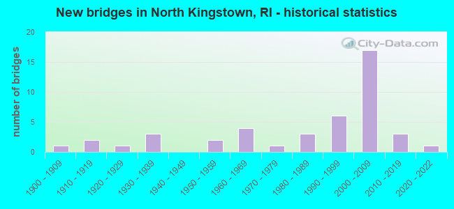
- New bridges - historical statistics
- 11900-1909
- 21910-1919
- 11920-1929
- 31930-1939
- 21950-1959
- 41960-1969
- 11970-1979
- 31980-1989
- 61990-1999
- 172000-2009
- 32010-2019
- 12020-2022

- Reconstructed bridges - Historical Statistics
- 21970-1979
- 31980-1989
- 51990-1999


- Bridge Condition - Deck
- 60.0%Good
- 30.0%Satisfactory
- 10.0%Fair

- Bridge Condition - Superstructure
- 6.5%Very good
- 35.5%Good
- 29.0%Satisfactory
- 19.4%Fair
- 6.5%Poor
- 3.2%Serious

- Bridge Condition - Substructure
- 3.2%Very good
- 58.1%Good
- 22.6%Satisfactory
- 12.9%Fair
- 3.2%Poor

- Bridge Condition - Channel
- 9.1%Very good
- 27.3%Good
- 45.5%Satisfactory
- 18.2%Fair

- Bridge Condition - Culverts
- 33.3%Good
- 66.7%Satisfactory
Find on map >> Show street view
Structure Number: 1003, Location: .07 Mi S of JCT RI 403 (Lat: 41.603667, Lng: -71.454611), Route carried "under" structure: Ramp State highway , Year Built: 2003, Structure Length: 0. m, Average Daily Traffic: 500 (year 2008), Truck Traffic: 3%, Features Intersected: Davisville Access Rd, Facility Carried by Structure: US 1 POST RD
Minimum Vertical Clearance: 7.32m (24.02ft), Kilometerpoint: 0.000, Lanes on structure: 5, Lanes under structure: 1, Material/Design: Prestressed concrete, Design/Construction: Stringer/Multi-beam, Length of Maximum Span: 32.9m (107.9ft)
Find on map >> Show street view
Structure Number: 1004, Location: .05 E US1 Post Rd (Lat: 41.603361, Lng: -71.453778), Route carried "under" structure: City street , Year Built: 2006, Structure Length: 0. m, Average Daily Traffic: 2,650 (year 2008), Truck Traffic: 6%, Features Intersected: Davisville Access Rd, Facility Carried by Structure: US 1 POST RD-RMP D
Minimum Vertical Clearance: 7.19m (23.59ft), Kilometerpoint: 0.000, Lanes on structure: 2, Lanes under structure: 2, Material/Design: Prestressed concrete, Design/Construction: Stringer/Multi-beam, Length of Maximum Span: 39.9m (130.9ft)
Find on map >> Show street view
Structure Number: 1006, Location: Jct RI 403 (Lat: 41.608625, Lng: -71.471878), Route carried "under" structure: US 403, Year Built: 2004, Structure Length: 0. m, Average Daily Traffic: 3,629 (year 2021), Truck Traffic: 17%, Features Intersected: RI 403, Facility Carried by Structure: W DAVISVILLE RD
Minimum Vertical Clearance: 5.08m (16.67ft), Kilometerpoint: 0.000, Lanes on structure: 2, Lanes under structure: 4, Material/Design: Prestressed concrete, Design/Construction: Stringer/Multi-beam, Length of Maximum Span: 35.7m (117.1ft)
Find on map >> Show street view
Structure Number: 1008, Location: 1.2 Mi W of JCT US1 (Lat: 41.613833, Lng: -71.474083), Route carried "under" structure: State highway 403, Year Built: 2007, Structure Length: 0. m, Average Daily Traffic: 5,000 (year 2008), Truck Traffic: 6%, Features Intersected: RI 403, Facility Carried by Structure: DEVILS FOOT RD
Minimum Vertical Clearance: 5.33m (17.49ft), Kilometerpoint: 0.000, Lanes on structure: 2, Lanes under structure: 4, Material/Design: Steel continuous, Design/Construction: Stringer/Multi-beam, Length of Maximum Span: 41.7m (136.8ft)
Find on map >> Show street view
Structure Number: 1011, Location: 0.1Mi.N.RI403 (Lat: 41.604194, Lng: -71.448556), Route carried "under" structure: Ramp State highway , Year Built: 2002, Structure Length: 0. m, Average Daily Traffic: 2,850 (year 2008), Truck Traffic: 2%, Features Intersected: RampEE/W.DavisvilleRD/RR, Facility Carried by Structure: RI 403 Ramp BB
Minimum Vertical Clearance: 7.03m (23.06ft), Kilometerpoint: 0.000, Lanes on structure: 2, Lanes under structure: 3, Material/Design: Prestressed concrete, Design/Construction: Stringer/Multi-beam, Length of Maximum Span: 39.3m (128.9ft)
Find on map >> Show street view
Structure Number: 1028, Location: 1 mi East of Post Rd (Lat: 41.607836, Lng: -71.438808), Route carried "under" structure: Spur County highway , Year Built: 2011, Structure Length: 0. m, Average Daily Traffic: 2,451 (year 2021), Truck Traffic: 14%, Features Intersected: DAVISVILLE RD, Facility Carried by Structure: ROMANO VINEYARDWAY
Minimum Vertical Clearance: 7.67m (25.16ft), Kilometerpoint: 0.000, Lanes on structure: 2, Lanes under structure: 2, Material/Design: Prestressed concrete, Design/Construction: Stringer/Multi-beam, Length of Maximum Span: 25.6m (84.0ft)