Bridge Statistics for North Las Vegas, Nevada (NV)
Condition, Traffic, Stress, Structural Evaluation, Project Costs
- National Bridge Inventory (NBI) Statistics
- 134Number of bridges
- 1,083ft / 330mTotal length
- $5,868,000Total costs
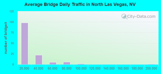
- 2,262,043Total average daily traffic
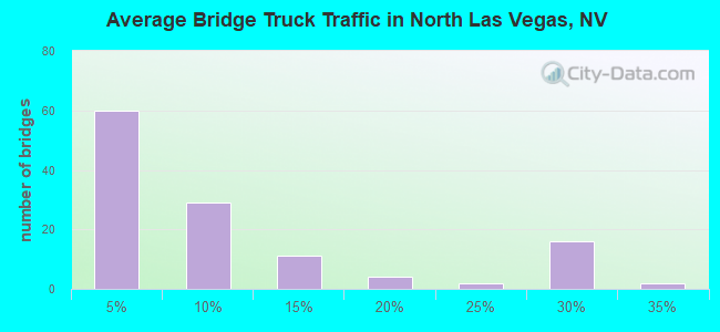
- 200,727Total average daily truck traffic
- National Bridge Inventory (NBI) Registered Bridges for North Las Vegas
- No street view available for this location
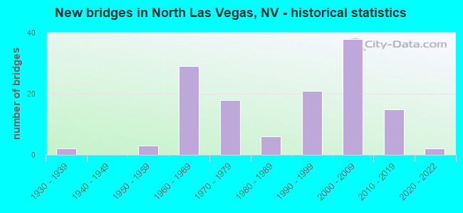
- New bridges - historical statistics
- 21930-1939
- 31950-1959
- 291960-1969
- 181970-1979
- 61980-1989
- 211990-1999
- 382000-2009
- 152010-2019
- 22020-2022
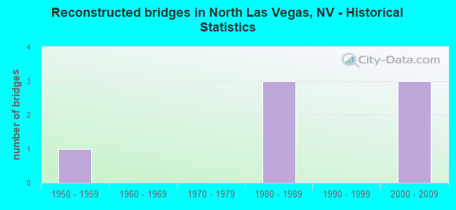
- Reconstructed bridges - Historical Statistics
- 11950-1959
- 01960-1969
- 01970-1979
- 31980-1989
- 01990-1999
- 32000-2009
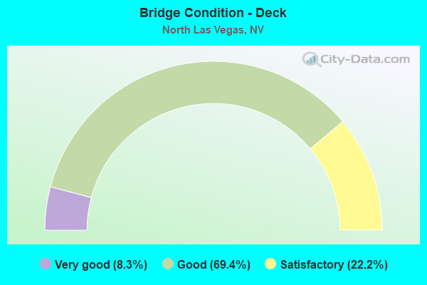
- Bridge Condition - Deck
- 8.3%Very good
- 69.4%Good
- 22.2%Satisfactory
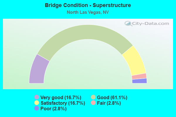
- Bridge Condition - Superstructure
- 16.7%Very good
- 61.1%Good
- 16.7%Satisfactory
- 2.8%Fair
- 2.8%Poor
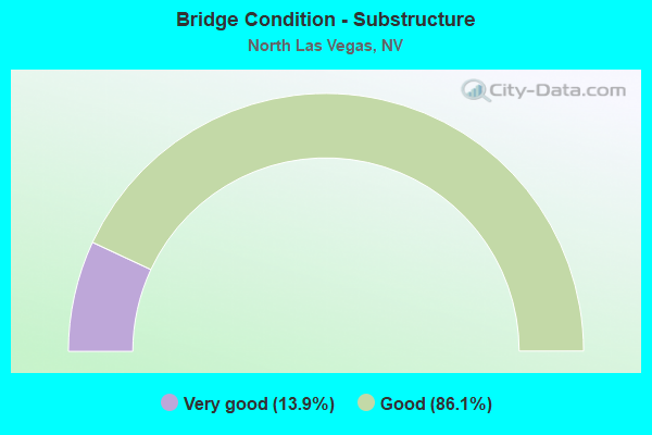
- Bridge Condition - Substructure
- 13.9%Very good
- 86.1%Good
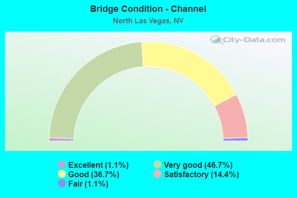
- Bridge Condition - Channel
- 1.1%Excellent
- 46.7%Very good
- 36.7%Good
- 14.4%Satisfactory
- 1.1%Fair
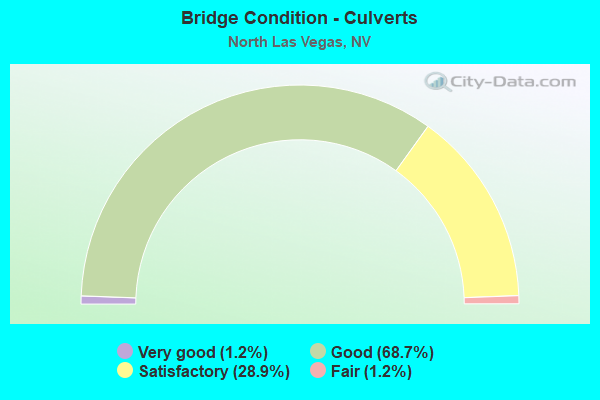
- Bridge Condition - Culverts
- 1.2%Very good
- 68.7%Good
- 28.9%Satisfactory
- 1.2%Fair
Find on map >> Show street view
Structure Number: G2568E, Location: NORTH LAS VEGAS (Lat: 36.280425, Lng: -115.064058), Route carried "on" structure: County highway 215, Year Built: 2001, Status: Open, Structure Length: 3.61m (11.84ft), Average Daily Traffic: 2,200 (year 2017), Truck Traffic: 10%, Average Future Daily Traffic: 5,000 (year 2040), Design Load: HS 20+Mod, Features Intersected: UNION PACIFIC RR
Minimum Vertical Clearance: 30+ m (98+ ft), Kilometerpoint: 0.000, Lanes on structure: 3, Base Highway Network: Yes, Owner: County Highway Agency, Approaching Roadway Width: 12.4m (40.7ft), Material/Design: Prestressed concrete, Design/Construction: Box Beam or Girders - Multiple, Number Of Spans In Main Unit: 1, Length of Maximum Span: 34.7m (113.8ft), Curb-To-Curb Width: 18.4m (60.4ft), Out-to-Out Width: 19.3m (63.3ft)
Condition: Deck: Good, Superstructure: Very good, Substructure: Good, Operating Rating: 90.5 metric tons, Method Used To Determine Operating Rating: Load Factor (LF), Inventory Rating: 50.6 metric tons, Method Used To Determine Inventory Rating: Load Factor (LF), Structural Evaluation: Better than present minimum criteria, Deck Geometry: Superior to present desirable criteria, Underclear: Superior to present desirable criteria, Approach Roadway Alignment: Equal to present desirable criteria, Designated Inspection Frequency: Every 24 months, Inspection Date: December 2019, Deck Structure Type: Concrete Cast-file-Place, Wearing Surface/Protective System: Wearing Surface: Monolithic Concrete
Find on map >> Show street view
Structure Number: G2568W, Location: NORTH LAS VEGAS (Lat: 36.280533, Lng: -115.063867), Route carried "on" structure: County highway 215, Year Built: 2001, Status: Open, Structure Length: 3.61m (11.84ft), Average Daily Traffic: 2,200 (year 2017), Truck Traffic: 10%, Average Future Daily Traffic: 5,000 (year 2040), Design Load: HS 20+Mod, Features Intersected: UNION PACIFIC RR
Minimum Vertical Clearance: 30+ m (98+ ft), Kilometerpoint: 0.000, Lanes on structure: 2, Base Highway Network: Yes, Owner: County Highway Agency, Approaching Roadway Width: 12.4m (40.7ft), Material/Design: Prestressed concrete, Design/Construction: Box Beam or Girders - Multiple, Number Of Spans In Main Unit: 1, Length of Maximum Span: 34.7m (113.8ft), Curb-To-Curb Width: 18.4m (60.4ft), Out-to-Out Width: 19.3m (63.3ft)
Condition: Deck: Good, Superstructure: Good, Substructure: Good, Operating Rating: 90.5 metric tons, Method Used To Determine Operating Rating: Load Factor (LF), Inventory Rating: 50.6 metric tons, Method Used To Determine Inventory Rating: Load Factor (LF), Structural Evaluation: Better than present minimum criteria, Deck Geometry: Superior to present desirable criteria, Underclear: Superior to present desirable criteria, Approach Roadway Alignment: Equal to present desirable criteria, Designated Inspection Frequency: Every 24 months, Inspection Date: December 2019, Deck Structure Type: Concrete Cast-file-Place, Wearing Surface/Protective System: Wearing Surface: Monolithic Concrete
Find on map >> Show street view
Structure Number: G2847, Location: NORTH LAS VEGAS (Lat: 36.265983, Lng: -115.079742), Route carried "on" structure: City street , Year Built: 2008, Status: Open, Structure Length: 12.85m (42.16ft), Average Daily Traffic: 34,000 (year 2017), Truck Traffic: 2%, Average Future Daily Traffic: 70,316 (year 2040), Design Load: HS 20+Mod, Features Intersected: RAIL ROAD & DONOVAN ROAD, Facility Carried by Structure: LAMB BLVD
Minimum Vertical Clearance: 30+ m (98+ ft), Kilometerpoint: 0.000, Lanes on structure: 8, Lanes under structure: 2, Owner: City or Municipal Highway Agency, Approaching Roadway Width: 32.0m (105.0ft), Skew: 25 degrees, Material/Design: Prestressed concrete, Design/Construction: Stringer/Multi-beam, Number Of Spans In Main Unit: 1, Number Of Approach Spans: 2, Length of Maximum Span: 48.0m (157.5ft), Curb or Sidewalk Widths: Left: 1.5m (4.9ft), Right: 1.5m (4.9ft), Curb-To-Curb Width: 29.6m (97.1ft), Out-to-Out Width: 36.3m (119.1ft)
Condition: Deck: Good, Superstructure: Good, Substructure: Good, Operating Rating: 42.4 metric tons, Method Used To Determine Operating Rating: Load and Resistance Factor (LRFR), Inventory Rating: 32.7 metric tons, Method Used To Determine Inventory Rating: Load and Resistance Factor (LRFR), Structural Evaluation: Better than present minimum criteria, Deck Geometry: Meets minimum limits, Underclear: Superior to present desirable criteria, Approach Roadway Alignment: Equal to present desirable criteria, Designated Inspection Frequency: Every 24 months, Inspection Date: Febuary 2021, Deck Structure Type: Concrete Cast-file-Place, Wearing Surface/Protective System: Wearing Surface: Monolithic Concrete
Find on map >> Show street view
Structure Number: H 948, Location: NORTH LAS VEGAS (Lat: 36.188356, Lng: -115.143228), Route carried "on" structure: City street 577, Year Built: 1970, Status: Open, Structure Length: 8.41m (27.59ft), Average Daily Traffic: 14,500 (year 2017), Truck Traffic: 4%, Average Future Daily Traffic: 29,988 (year 2040), Design Load: HS 20+Mod, Features Intersected: I 15, Facility Carried by Structure: OWENS AV
Minimum Vertical Clearance: 30+ m (98+ ft), Kilometerpoint: 71.032, Lanes on structure: 4, Lanes under structure: 10, Owner: State Highway Agency, Approaching Roadway Width: 17.1m (56.1ft), Skew: 21 degrees, Material/Design: Steel, Design/Construction: Stringer/Multi-beam, Number Of Spans In Main Unit: 2, Number Of Approach Spans: 2, Length of Maximum Span: 31.1m (102.0ft), Curb or Sidewalk Widths: Left: 1.5m (4.9ft), Right: 1.5m (4.9ft), Curb-To-Curb Width: 17.1m (56.1ft), Out-to-Out Width: 21.0m (68.9ft)
Condition: Deck: Good, Superstructure: Satisfactory, Substructure: Good, Operating Rating: 55.1 metric tons, Method Used To Determine Operating Rating: Load Factor (LF), Inventory Rating: 32.9 metric tons, Method Used To Determine Inventory Rating: Load Factor (LF), Structural Evaluation: Equal to present minimum criteria, Deck Geometry: Somewhat better than minimum adequacy, Underclear: Meets minimum limits, Approach Roadway Alignment: Equal to present desirable criteria, Length Of Structure Improvement: 9.40m (30.84ft), Designated Inspection Frequency: Every 24 months, Inspection Date: January 2021, Bridge Improvement Cost: $1,619,000, Roadway Improvement Cost: $162,000, Total Project Cost: $2,429,000, Deck Structure Type: Concrete Cast-file-Place, Wearing Surface/Protective System: Wearing Surface: Bituminous
Find on map >> Show street view
Structure Number: H 97, Location: NORTH OF LAS VEGAS (Lat: 36.329692, Lng: -114.923194), Route carried "on" structure: ServiceOther road , Year Built: 1963, Status: Open, Structure Length: 4.33m (14.21ft), Average Daily Traffic: 1,825 (year 2017), Truck Traffic: 3%, Average Future Daily Traffic: 2,000 (year 2040), Features Intersected: I 15, Facility Carried by Structure: PRIVATE ROAD
Minimum Vertical Clearance: 30+ m (98+ ft), Kilometerpoint: 0.000, Lanes on structure: 2, Lanes under structure: 4, Owner: State Highway Agency, Approaching Roadway Width: 7.9m (25.9ft), Skew: 2 degrees, Material/Design: Concrete continuous, Design/Construction: Box Beam or Girders - Single/Spread, Number Of Spans In Main Unit: 2, Length of Maximum Span: 21.9m (71.9ft), Curb or Sidewalk Widths: Left: 0.3m (1.0ft), Right: 0.3m (1.0ft), Curb-To-Curb Width: 7.3m (24.0ft), Out-to-Out Width: 8.5m (27.9ft)
Condition: Deck: Satisfactory, Superstructure: Satisfactory, Substructure: Good, Inventory Rating: 61.7 metric tons, Method Used To Determine Inventory Rating: Load Factor (LF), Structural Evaluation: Equal to present minimum criteria, Deck Geometry: Meets minimum limits, Underclear: High priority of replacement, Approach Roadway Alignment: Equal to present desirable criteria, Length Of Structure Improvement: 5.50m (18.04ft), Designated Inspection Frequency: Every 24 months, Inspection Date: November 2020, Bridge Improvement Cost: $442,000, Roadway Improvement Cost: $44,000, Total Project Cost: $663,000, Deck Structure Type: Concrete Cast-file-Place, Wearing Surface/Protective System: Wearing Surface: Bituminous
Find on map >> Show street view
Structure Number: H1217N, Location: NORTH LAS VEGAS (Lat: 36.225636, Lng: -115.246694), Route carried "on" structure: US 95, Year Built: 1977, Status: Open, Structure Length: 3.81m (12.50ft), Average Daily Traffic: 73,000 (year 2017), Truck Traffic: 5%, Average Future Daily Traffic: 150,973 (year 2040), Design Load: HS 20+Mod, Features Intersected: GOWAN RD
Minimum Vertical Clearance: 30+ m (98+ ft), Kilometerpoint: 141.482, Lanes on structure: 6, Lanes under structure: 2, Base Highway Network: Yes, Owner: State Highway Agency, Approaching Roadway Width: 17.7m (58.1ft), Material/Design: Concrete continuous, Design/Construction: Slab, Number Of Spans In Main Unit: 3, Length of Maximum Span: 17.1m (56.1ft), Curb-To-Curb Width: 26.5m (86.9ft), Out-to-Out Width: 27.4m (89.9ft)
Condition: Deck: Good, Superstructure: Good, Substructure: Good, Operating Rating: 90.4 metric tons, Method Used To Determine Operating Rating: Load Factor (LF), Inventory Rating: 54.1 metric tons, Method Used To Determine Inventory Rating: Load Factor (LF), Structural Evaluation: Better than present minimum criteria, Deck Geometry: Somewhat better than minimum adequacy, Underclear: Meets minimum limits, Approach Roadway Alignment: Equal to present desirable criteria, Designated Inspection Frequency: Every 24 months, Inspection Date: January 2020, Deck Structure Type: Concrete Cast-file-Place, Wearing Surface/Protective System: Wearing Surface: Monolithic Concrete
Find on map >> Show street view
Structure Number: H1217S, Location: NORTH LAS VEGAS (Lat: 36.225631, Lng: -115.246983), Route carried "on" structure: US 95, Year Built: 1977, Status: Open, Structure Length: 3.81m (12.50ft), Average Daily Traffic: 73,000 (year 2017), Truck Traffic: 5%, Average Future Daily Traffic: 150,973 (year 2040), Design Load: HS 20+Mod, Features Intersected: GOWAN RD
Minimum Vertical Clearance: 30+ m (98+ ft), Kilometerpoint: 141.482, Lanes on structure: 5, Lanes under structure: 2, Base Highway Network: Yes, Owner: State Highway Agency, Approaching Roadway Width: 17.7m (58.1ft), Material/Design: Concrete continuous, Design/Construction: Slab, Number Of Spans In Main Unit: 3, Length of Maximum Span: 17.1m (56.1ft), Curb-To-Curb Width: 26.5m (86.9ft), Out-to-Out Width: 27.4m (89.9ft)
Condition: Deck: Good, Superstructure: Good, Substructure: Good, Operating Rating: 90.4 metric tons, Method Used To Determine Operating Rating: Load Factor (LF), Inventory Rating: 54.1 metric tons, Method Used To Determine Inventory Rating: Load Factor (LF), Structural Evaluation: Better than present minimum criteria, Deck Geometry: Superior to present desirable criteria, Underclear: Meets minimum limits, Approach Roadway Alignment: Equal to present desirable criteria, Designated Inspection Frequency: Every 24 months, Inspection Date: January 2020, Deck Structure Type: Concrete Cast-file-Place, Wearing Surface/Protective System: Wearing Surface: Monolithic Concrete
Find on map >> Show street view
Structure Number: H2826N, Location: NORTH OF LAS VEGAS (Lat: 36.208417, Lng: -115.133972), Route carried "on" structure: City street , Year Built: 2015, Status: Open, Structure Length: 15.30m (50.20ft), Average Daily Traffic: 2,050 (year 2017), Truck Traffic: 1%, Average Future Daily Traffic: 4,240 (year 2040), Design Load: HL 93, Features Intersected: LOSEE ROAD, Facility Carried by Structure: NORTH 5TH STREET
Minimum Vertical Clearance: 30+ m (98+ ft), Kilometerpoint: 0.000, Lanes on structure: 3, Lanes under structure: 4, Owner: City or Municipal Highway Agency, Approaching Roadway Width: 14.6m (47.9ft), Material/Design: Prestressed concrete continuous, Design/Construction: Box Beam or Girders - Single/Spread, Number Of Spans In Main Unit: 2, Length of Maximum Span: 76.2m (250.0ft), Curb or Sidewalk Widths: Left: 0.0m, Right: 3.7m (12.1ft), Curb-To-Curb Width: 14.6m (47.9ft), Out-to-Out Width: 18.9m (62.0ft)
Condition: Deck: Good, Superstructure: Good, Substructure: Good, Operating Rating: 51.5 metric tons, Method Used To Determine Operating Rating: Load and Resistance Factor (LRFR), Inventory Rating: 39.2 metric tons, Method Used To Determine Inventory Rating: Load and Resistance Factor (LRFR), Structural Evaluation: Better than present minimum criteria, Deck Geometry: Somewhat better than minimum adequacy, Underclear: Somewhat better than minimum adequacy, Approach Roadway Alignment: Equal to present desirable criteria, Designated Inspection Frequency: Every 24 months, Inspection Date: September 2020, Deck Structure Type: Concrete Cast-file-Place, Wearing Surface/Protective System: Wearing Surface: Monolithic Concrete
Find on map >> Show street view
Structure Number: H2826S, Location: NORTH OF LAS VEGAS (Lat: 36.208417, Lng: -115.133972), Route carried "on" structure: City street , Year Built: 2015, Status: Open, Structure Length: 13.11m (43.01ft), Average Daily Traffic: 2,050 (year 2017), Truck Traffic: 1%, Average Future Daily Traffic: 4,240 (year 2040), Design Load: HL 93, Features Intersected: LOSEE ROAD, Facility Carried by Structure: NORTH 5TH STREET
Minimum Vertical Clearance: 30+ m (98+ ft), Kilometerpoint: 0.000, Lanes on structure: 3, Lanes under structure: 4, Owner: City or Municipal Highway Agency, Approaching Roadway Width: 16.6m (54.5ft), Material/Design: Prestressed concrete continuous, Design/Construction: Box Beam or Girders - Single/Spread, Number Of Spans In Main Unit: 2, Length of Maximum Span: 74.4m (244.1ft), Curb-To-Curb Width: 16.6m (54.5ft), Out-to-Out Width: 17.7m (58.1ft)
Condition: Deck: Good, Superstructure: Good, Substructure: Very good, Operating Rating: 51.5 metric tons, Method Used To Determine Operating Rating: Load and Resistance Factor (LRFR), Inventory Rating: 39.2 metric tons, Method Used To Determine Inventory Rating: Load and Resistance Factor (LRFR), Structural Evaluation: Better than present minimum criteria, Deck Geometry: Equal to present desirable criteria, Underclear: Superior to present desirable criteria, Approach Roadway Alignment: Equal to present desirable criteria, Designated Inspection Frequency: Every 24 months, Inspection Date: September 2020, Deck Structure Type: Concrete Cast-file-Place, Wearing Surface/Protective System: Wearing Surface: Monolithic Concrete
Find on map >> Show street view
Structure Number: I 956, Location: NORTH LAS VEGAS (Lat: 36.240219, Lng: -115.101775), Route carried "on" structure: State highway 573, Year Built: 1970, Year Reconstructed: 1986, Status: Open, Structure Length: 9.57m (31.40ft), Average Daily Traffic: 54,000 (year 2017), Truck Traffic: 4%, Average Future Daily Traffic: 68,000 (year 2040), Design Load: HS 20+Mod, Features Intersected: I 15
Minimum Vertical Clearance: 30+ m (98+ ft), Kilometerpoint: 77.958, Lanes on structure: 9, Lanes under structure: 7, Base Highway Network: Yes, Owner: State Highway Agency, Approaching Roadway Width: 23.1m (75.8ft), Skew: 24 degrees, Material/Design: Prestressed concrete, Design/Construction: Box Beam or Girders - Multiple, Number Of Spans In Main Unit: 2, Number Of Approach Spans: 2, Length of Maximum Span: 39.6m (129.9ft), Curb or Sidewalk Widths: Left: 1.2m (3.9ft), Right: 1.2m (3.9ft), Curb-To-Curb Width: 37.0m (121.4ft), Out-to-Out Width: 40.3m (132.2ft)
Condition: Deck: Satisfactory, Superstructure: Fair, Substructure: Good, Operating Rating: 67.2 metric tons, Method Used To Determine Operating Rating: Load Factor (LF), Inventory Rating: 43.1 metric tons, Method Used To Determine Inventory Rating: Load Factor (LF), Structural Evaluation: Somewhat better than minimum adequacy, Deck Geometry: Equal to present minimum criteria, Underclear: Somewhat better than minimum adequacy, Approach Roadway Alignment: Equal to present desirable criteria, Designated Inspection Frequency: Every 24 months, Inspection Date: December 2020, Deck Structure Type: Concrete Cast-file-Place, Wearing Surface/Protective System: Wearing Surface: Bituminous
Find on map >> Show street view
Structure Number: I 959N, Location: NORTH LAS VEGAS (Lat: 36.258119, Lng: -115.079794), Route carried "on" structure: Interstate 15, Year Built: 2005, Status: Open, Structure Length: 7.11m (23.33ft), Average Daily Traffic: 15,025 (year 2017), Truck Traffic: 10%, Average Future Daily Traffic: 68,000 (year 2040), Design Load: HS 20+Mod, Features Intersected: SR610 LAMB BLVD
Minimum Vertical Clearance: 30+ m (98+ ft), Kilometerpoint: 80.710, Lanes on structure: 3, Lanes under structure: 6, Base Highway Network: Yes, Owner: State Highway Agency, Approaching Roadway Width: 14.6m (47.9ft), Skew: 4 degrees, Material/Design: Prestressed concrete, Design/Construction: Box Beam or Girders - Multiple, Number Of Spans In Main Unit: 1, Length of Maximum Span: 69.5m (228.0ft), Curb-To-Curb Width: 14.6m (47.9ft), Out-to-Out Width: 19.2m (63.0ft)
Condition: Deck: Good, Superstructure: Good, Substructure: Good, Operating Rating: 89.1 metric tons, Method Used To Determine Operating Rating: Load Factor (LF), Inventory Rating: 53.2 metric tons, Method Used To Determine Inventory Rating: Load Factor (LF), Structural Evaluation: Better than present minimum criteria, Deck Geometry: Meets minimum limits, Underclear: Meets minimum limits, Approach Roadway Alignment: Equal to present desirable criteria, Designated Inspection Frequency: Every 24 months, Inspection Date: October 2020, Deck Structure Type: Concrete Cast-file-Place, Wearing Surface/Protective System: Wearing Surface: Monolithic Concrete
Find on map >> Show street view
Structure Number: I 959S, Location: NORTH LAS VEGAS (Lat: 36.258494, Lng: -115.079825), Route carried "on" structure: Interstate 15, Year Built: 2005, Status: Open, Structure Length: 7.11m (23.33ft), Average Daily Traffic: 24,000 (year 2017), Truck Traffic: 10%, Average Future Daily Traffic: 49,635 (year 2040), Design Load: HS 20+Mod, Features Intersected: SR610 LAMB BLVD
Minimum Vertical Clearance: 30+ m (98+ ft), Kilometerpoint: 80.710, Lanes on structure: 3, Lanes under structure: 6, Base Highway Network: Yes, Owner: State Highway Agency, Approaching Roadway Width: 14.6m (47.9ft), Skew: 4 degrees, Material/Design: Prestressed concrete, Design/Construction: Box Beam or Girders - Multiple, Number Of Spans In Main Unit: 1, Length of Maximum Span: 69.5m (228.0ft), Curb-To-Curb Width: 14.6m (47.9ft), Out-to-Out Width: 19.2m (63.0ft)
Condition: Deck: Good, Superstructure: Good, Substructure: Good, Operating Rating: 89.1 metric tons, Method Used To Determine Operating Rating: Load Factor (LF), Inventory Rating: 53.2 metric tons, Method Used To Determine Inventory Rating: Load Factor (LF), Structural Evaluation: Better than present minimum criteria, Deck Geometry: Meets minimum limits, Underclear: Meets minimum limits, Approach Roadway Alignment: Equal to present desirable criteria, Designated Inspection Frequency: Every 24 months, Inspection Date: October 2020, Deck Structure Type: Concrete Cast-file-Place, Wearing Surface/Protective System: Wearing Surface: Monolithic Concrete
Find on map >> Show street view
Structure Number: I 965S, Location: NORTH OF LAS VEGAS (Lat: 36.282806, Lng: -115.026297), Route carried "on" structure: Interstate 15, Year Built: 1963, Status: Open, Structure Length: 5.30m (17.39ft), Average Daily Traffic: 11,550 (year 2017), Truck Traffic: 27%, Average Future Daily Traffic: 14,523 (year 2040), Design Load: HS 20+Mod, Features Intersected: SPEEDWAY INTERCHANGE
Minimum Vertical Clearance: 30+ m (98+ ft), Kilometerpoint: 86.359, Lanes on structure: 2, Lanes under structure: 5, Base Highway Network: Yes, Owner: State Highway Agency, Approaching Roadway Width: 11.6m (38.1ft), Skew: 2 degrees, Material/Design: Concrete continuous, Design/Construction: Tee Beam, Number Of Spans In Main Unit: 3, Length of Maximum Span: 21.3m (69.9ft), Curb-To-Curb Width: 11.6m (38.1ft), Out-to-Out Width: 13.1m (43.0ft)
Condition: Deck: Good, Superstructure: Good, Substructure: Good, Operating Rating: 56.1 metric tons, Method Used To Determine Operating Rating: Load Factor (LF), Inventory Rating: 33.9 metric tons, Method Used To Determine Inventory Rating: Load Factor (LF), Structural Evaluation: Better than present minimum criteria, Deck Geometry: Equal to present minimum criteria, Underclear: High priority of corrective action, Approach Roadway Alignment: Equal to present desirable criteria, Designated Inspection Frequency: Every 24 months, Inspection Date: November 2020, Deck Structure Type: Concrete Cast-file-Place, Wearing Surface/Protective System: Wearing Surface: Bituminous
Find on map >> Show street view
Structure Number: I 969N, Location: NORTH LAS VEGAS (Lat: 36.309886, Lng: -114.952706), Route carried "on" structure: Interstate 15, Year Built: 1963, Status: Open, Structure Length: 4.08m (13.39ft), Average Daily Traffic: 11,725 (year 2017), Truck Traffic: 25%, Average Future Daily Traffic: 14,000 (year 2040), Design Load: HS 20+Mod, Features Intersected: SR604 LAS VEGAS BL
Minimum Vertical Clearance: 30+ m (98+ ft), Kilometerpoint: 93.627, Lanes on structure: 2, Lanes under structure: 2, Base Highway Network: Yes, Owner: State Highway Agency, Approaching Roadway Width: 11.6m (38.1ft), Skew: 2 degrees, Material/Design: Concrete continuous, Design/Construction: Box Beam or Girders - Multiple, Number Of Spans In Main Unit: 3, Length of Maximum Span: 15.4m (50.5ft), Curb-To-Curb Width: 11.6m (38.1ft), Out-to-Out Width: 13.1m (43.0ft)
Condition: Deck: Good, Superstructure: Good, Substructure: Good, Operating Rating: 61.0 metric tons, Method Used To Determine Operating Rating: Load Factor (LF), Inventory Rating: 36.6 metric tons, Method Used To Determine Inventory Rating: Load Factor (LF), Structural Evaluation: Better than present minimum criteria, Deck Geometry: Equal to present minimum criteria, Underclear: Somewhat better than minimum adequacy, Approach Roadway Alignment: Equal to present desirable criteria, Designated Inspection Frequency: Every 48 months, Inspection Date: October 2020, Deck Structure Type: Concrete Cast-file-Place, Wearing Surface/Protective System: Wearing Surface: Bituminous
Find on map >> Show street view
Structure Number: I 969S, Location: NORTH LAS VEGAS (Lat: 36.310444, Lng: -114.952561), Route carried "on" structure: Interstate 15, Year Built: 1963, Status: Open, Structure Length: 4.08m (13.39ft), Average Daily Traffic: 11,725 (year 2017), Truck Traffic: 25%, Average Future Daily Traffic: 14,000 (year 2040), Design Load: HS 20+Mod, Features Intersected: SR604 LAS VEGAS BL
Minimum Vertical Clearance: 30+ m (98+ ft), Kilometerpoint: 93.627, Lanes on structure: 2, Lanes under structure: 2, Base Highway Network: Yes, Owner: State Highway Agency, Approaching Roadway Width: 11.6m (38.1ft), Skew: 2 degrees, Material/Design: Concrete continuous, Design/Construction: Box Beam or Girders - Multiple, Number Of Spans In Main Unit: 3, Length of Maximum Span: 15.8m (51.8ft), Curb-To-Curb Width: 11.6m (38.1ft), Out-to-Out Width: 13.1m (43.0ft)
Condition: Deck: Good, Superstructure: Poor, Substructure: Good, Operating Rating: 61.0 metric tons, Method Used To Determine Operating Rating: Load Factor (LF), Inventory Rating: 36.6 metric tons, Method Used To Determine Inventory Rating: Load Factor (LF), Structural Evaluation: Meets minimum limits, Deck Geometry: Equal to present minimum criteria, Underclear: Somewhat better than minimum adequacy, Approach Roadway Alignment: Equal to present desirable criteria, Designated Inspection Frequency: Every 24 months, Other Special Inspection Frequency: Every 24 months, Inspection Date: October 2020, Other Special Inspection Date: October 2021, Deck Structure Type: Concrete Cast-file-Place, Wearing Surface/Protective System: Wearing Surface: Bituminous
Find on map >> Show street view
Structure Number: I1126, Location: NORTH LAS VEGAS (Lat: 36.217872, Lng: -115.123886), Route carried "on" structure: State highway 574, Year Built: 1999, Status: Open, Structure Length: 6.85m (22.47ft), Average Daily Traffic: 66,000 (year 2017), Truck Traffic: 10%, Average Future Daily Traffic: 84,000 (year 2040), Design Load: HS 20+Mod, Features Intersected: I 15
Minimum Vertical Clearance: 30+ m (98+ ft), Kilometerpoint: 11.243, Lanes on structure: 8, Lanes under structure: 8, Base Highway Network: Yes, Owner: State Highway Agency, Approaching Roadway Width: 24.0m (78.7ft), Skew: 3 degrees, Material/Design: Prestressed concrete continuous, Design/Construction: Box Beam or Girders - Single/Spread, Number Of Spans In Main Unit: 2, Length of Maximum Span: 28.0m (91.9ft), Curb or Sidewalk Widths: Left: 1.7m (5.6ft), Right: 0.0m, Curb-To-Curb Width: 64.0m (210.0ft), Out-to-Out Width: 66.5m (218.2ft)
Condition: Deck: Satisfactory, Superstructure: Good, Substructure: Good, Operating Rating: 58.8 metric tons, Method Used To Determine Operating Rating: Load Factor (LF), Inventory Rating: 34.6 metric tons, Method Used To Determine Inventory Rating: Load Factor (LF), Structural Evaluation: Better than present minimum criteria, Deck Geometry: Superior to present desirable criteria, Underclear: Equal to present minimum criteria, Approach Roadway Alignment: Equal to present desirable criteria, Designated Inspection Frequency: Every 48 months, Inspection Date: Febuary 2021, Deck Structure Type: Concrete Cast-file-Place, Wearing Surface/Protective System: Wearing Surface: Monolithic Concrete
Find on map >> Show street view
Structure Number: I233, Location: NORTH OF LAS VEGAS (Lat: 36.289814, Lng: -115.180294), Route carried "on" structure: City street , Year Built: 2009, Status: Open, Structure Length: 8.53m (27.99ft), Average Daily Traffic: 23,100 (year 2017), Truck Traffic: 2%, Average Future Daily Traffic: 47,774 (year 2040), Design Load: HS 20+Mod, Features Intersected: CC 215, Facility Carried by Structure: ALIANTE PKWY
Minimum Vertical Clearance: 30+ m (98+ ft), Kilometerpoint: 0.000, Lanes on structure: 10, Lanes under structure: 4, Owner: County Highway Agency, Approaching Roadway Width: 31.0m (101.7ft), Skew: 20 degrees, Material/Design: Prestressed concrete continuous, Design/Construction: Box Beam or Girders - Single/Spread, Number Of Spans In Main Unit: 2, Length of Maximum Span: 44.5m (146.0ft), Curb or Sidewalk Widths: Left: 1.7m (5.6ft), Right: 1.7m (5.6ft), Curb-To-Curb Width: 41.4m (135.8ft), Out-to-Out Width: 46.0m (150.9ft)
Condition: Deck: Good, Superstructure: Good, Substructure: Good, Operating Rating: 69.1 metric tons, Method Used To Determine Operating Rating: Load Factor (LF), Inventory Rating: 41.5 metric tons, Method Used To Determine Inventory Rating: Load Factor (LF), Structural Evaluation: Better than present minimum criteria, Deck Geometry: Equal to present minimum criteria, Underclear: Better than present minimum criteria, Approach Roadway Alignment: Equal to present desirable criteria, Designated Inspection Frequency: Every 24 months, Inspection Date: Febuary 2021, Deck Structure Type: Concrete Cast-file-Place, Wearing Surface/Protective System: Wearing Surface: Monolithic Concrete
Find on map >> Show street view
Structure Number: I259, Location: NORTH CC215 (Lat: 36.293231, Lng: -115.153606), Route carried "on" structure: City street , Year Built: 2016, Status: Open, Structure Length: 8.35m (27.40ft), Average Daily Traffic: 100 (year 2017), Average Future Daily Traffic: 100 (year 2040), Design Load: HS 25 or greater, Features Intersected: CC 215, Facility Carried by Structure: REVERE STREET
Minimum Vertical Clearance: 30+ m (98+ ft), Kilometerpoint: 0.000, Lanes on structure: 10, Lanes under structure: 4, Owner: County Highway Agency, Approaching Roadway Width: 31.7m (104.0ft), Skew: 20 degrees, Material/Design: Prestressed concrete continuous, Design/Construction: Box Beam or Girders - Single/Spread, Number Of Spans In Main Unit: 2, Length of Maximum Span: 41.5m (136.2ft), Curb or Sidewalk Widths: Left: 1.7m (5.6ft), Right: 1.7m (5.6ft), Curb-To-Curb Width: 42.1m (138.1ft), Out-to-Out Width: 46.0m (150.9ft)
Condition: Deck: Very good, Superstructure: Very good, Substructure: Very good, Operating Rating: 33.6 metric tons, Method Used To Determine Operating Rating: Load and Resistance Factor (LRFR), Inventory Rating: 26.1 metric tons, Method Used To Determine Inventory Rating: Load and Resistance Factor (LRFR), Structural Evaluation: Equal to present minimum criteria, Deck Geometry: Better than present minimum criteria, Underclear: Superior to present desirable criteria, Approach Roadway Alignment: Equal to present desirable criteria, Designated Inspection Frequency: Every 24 months, Inspection Date: December 2020, Deck Structure Type: Concrete Cast-file-Place, Wearing Surface/Protective System: Wearing Surface: Monolithic Concrete
Find on map >> Show street view
Structure Number: I2941, Location: BTW 5TH St. and Pecos Rd (Lat: 36.289444, Lng: -115.116944), Route carried "on" structure: Alternate City street , Year Built: 2020, Status: Open, Structure Length: 9.01m (29.56ft), Average Daily Traffic: 11,600 (year 2019), Truck Traffic: 2%, Average Future Daily Traffic: 16,000 (year 2037), Design Load: HL 93, Features Intersected: CC215 BRUCE WOODBURY BW, Facility Carried by Structure: LOSEE ROAD
Minimum Vertical Clearance: 30+ m (98+ ft), Kilometerpoint: 0.000, Lanes on structure: 7, Lanes under structure: 4, Owner: County Highway Agency, Approaching Roadway Width: 19.4m (63.6ft), Skew: 20 degrees, Material/Design: Prestressed concrete, Design/Construction: Box Beam or Girders - Single/Spread, Number Of Spans In Main Unit: 2, Length of Maximum Span: 45.4m (149.0ft), Curb or Sidewalk Widths: Left: 1.7m (5.6ft), Right: 1.7m (5.6ft), Curb-To-Curb Width: 39.9m (130.9ft), Out-to-Out Width: 43.9m (144.0ft)
Condition: Deck: Very good, Superstructure: Very good, Substructure: Good, Structural Evaluation: Better than present minimum criteria, Deck Geometry: Superior to present desirable criteria, Underclear: Better than present minimum criteria, Approach Roadway Alignment: Equal to present desirable criteria, Designated Inspection Frequency: Every 24 months, Inspection Date: October 2021, Deck Structure Type: Concrete Cast-file-Place, Wearing Surface/Protective System: Wearing Surface: Monolithic Concrete
Find on map >> Show street view
Structure Number: I2943, Location: BTW N PECOS RD & UPRR (Lat: 36.289719, Lng: -115.079906), Route carried "on" structure: Alternate City street , Year Built: 2019, Status: Open, Structure Length: 9.01m (29.56ft), Average Daily Traffic: 500 (year 2018), Truck Traffic: 1%, Average Future Daily Traffic: 2,500 (year 2038), Design Load: HL 93, Features Intersected: I 215 BRUCE WOODBURY BW, Facility Carried by Structure: N LAMB BOULEVARD
Minimum Vertical Clearance: 30+ m (98+ ft), Lanes on structure: 7, Lanes under structure: 4, Base Highway Network: Yes, Owner: County Highway Agency, Approaching Roadway Width: 39.3m (128.9ft), Skew: 20 degrees, Material/Design: Prestressed concrete, Design/Construction: Box Beam or Girders - Multiple, Number Of Spans In Main Unit: 2, Length of Maximum Span: 45.7m (149.9ft), Curb or Sidewalk Widths: Left: 1.7m (5.6ft), Right: 1.7m (5.6ft), Curb-To-Curb Width: 39.6m (129.9ft), Out-to-Out Width: 43.9m (144.0ft)
Condition: Deck: Very good, Superstructure: Very good, Substructure: Very good, Structural Evaluation: Equal to present desirable criteria, Deck Geometry: Superior to present desirable criteria, Underclear: Superior to present desirable criteria, Approach Roadway Alignment: Equal to present desirable criteria, Designated Inspection Frequency: Every 24 months, Inspection Date: October 2021, Deck Structure Type: Concrete Cast-file-Place, Wearing Surface/Protective System: Wearing Surface: Monolithic Concrete
Find on map >> Show street view
Structure Number: I3233N, Location: NORTH OF LAS VEGAS (Lat: 36.380811, Lng: -114.891511), Route carried "on" structure: Interstate 15, Year Built: 2019, Status: Open, Structure Length: 3.17m (10.40ft), Average Daily Traffic: 15,000 (year 2017), Truck Traffic: 18%, Average Future Daily Traffic: 16,500 (year 2037), Design Load: HL 93, Features Intersected: US 93 GARNET INTERCH
Minimum Vertical Clearance: 30+ m (98+ ft), Kilometerpoint: 103.524, Lanes on structure: 2, Lanes under structure: 4, Base Highway Network: Yes, Owner: State Highway Agency, Approaching Roadway Width: 11.4m (37.4ft), Material/Design: Prestressed concrete, Design/Construction: Stringer/Multi-beam, Number Of Spans In Main Unit: 1, Length of Maximum Span: 31.1m (102.0ft), Curb-To-Curb Width: 17.7m (58.1ft), Out-to-Out Width: 18.6m (61.0ft)
Condition: Deck: Good, Superstructure: Good, Substructure: Very good, Operating Rating: 60.4 metric tons, Method Used To Determine Operating Rating: Load and Resistance Factor (LRFR), Inventory Rating: 33.7 metric tons, Method Used To Determine Inventory Rating: Load and Resistance Factor (LRFR), Structural Evaluation: Better than present minimum criteria, Deck Geometry: Superior to present desirable criteria, Underclear: Somewhat better than minimum adequacy, Approach Roadway Alignment: Equal to present desirable criteria, Designated Inspection Frequency: Every 24 months, Inspection Date: Febuary 2021, Deck Structure Type: Concrete Precast Panels, Wearing Surface/Protective System: Wearing Surface: Epoxy Overlay
Find on map >> Show street view
Structure Number: I3233S, Location: NORTH OF LAS VEGAS (Lat: 36.380950, Lng: -114.891511), Route carried "on" structure: Interstate 15, Year Built: 2019, Status: Open, Structure Length: 3.17m (10.40ft), Average Daily Traffic: 9,700 (year 2017), Truck Traffic: 18%, Average Future Daily Traffic: 13,440 (year 2040), Design Load: HL 93, Features Intersected: US 93 GARNET INTERCH
Minimum Vertical Clearance: 30+ m (98+ ft), Kilometerpoint: 103.524, Lanes on structure: 2, Lanes under structure: 4, Base Highway Network: Yes, Owner: State Highway Agency, Approaching Roadway Width: 11.4m (37.4ft), Material/Design: Prestressed concrete, Design/Construction: Stringer/Multi-beam, Number Of Spans In Main Unit: 1, Length of Maximum Span: 31.1m (102.0ft), Curb-To-Curb Width: 17.7m (58.1ft), Out-to-Out Width: 18.6m (61.0ft)
Condition: Deck: Good, Superstructure: Very good, Substructure: Very good, Operating Rating: 60.4 metric tons, Method Used To Determine Operating Rating: Load and Resistance Factor (LRFR), Inventory Rating: 33.7 metric tons, Method Used To Determine Inventory Rating: Load and Resistance Factor (LRFR), Structural Evaluation: Equal to present desirable criteria, Deck Geometry: Superior to present desirable criteria, Underclear: Somewhat better than minimum adequacy, Approach Roadway Alignment: Equal to present desirable criteria, Designated Inspection Frequency: Every 24 months, Inspection Date: Febuary 2021, Deck Structure Type: Concrete Precast Panels, Wearing Surface/Protective System: Wearing Surface: Epoxy Overlay
Find on map >> Show street view
Structure Number: M1536B, Location: N LAS VEGAS E BRIDGE (Lat: 36.217650, Lng: -115.107514), Route carried "on" structure: City street 574, Year Built: 1967, Status: Open, Structure Length: 1.13m (3.71ft), Average Daily Traffic: 36,000 (year 2017), Truck Traffic: 4%, Average Future Daily Traffic: 74,452 (year 2040), Design Load: HS 20, Features Intersected: LAS VEGAS WASH
Minimum Vertical Clearance: 30+ m (98+ ft), Kilometerpoint: 0.000, Lanes on structure: 7, Base Highway Network: Yes, Owner: City or Municipal Highway Agency, Approaching Roadway Width: 24.7m (81.0ft), Skew: 20 degrees, Material/Design: Steel, Design/Construction: Culvert, Number Of Spans In Main Unit: 2, Length of Maximum Span: 4.6m (15.1ft), Curb or Sidewalk Widths: Left: 1.5m (4.9ft), Right: 1.5m (4.9ft)
Condition: Channel: Very good, Culverts: Good, Structural Evaluation: Better than present minimum criteria, Waterway Adequacy: Equal to present desirable criteria, Approach Roadway Alignment: Equal to present desirable criteria, Length Of Structure Improvement: 1.80m (5.91ft), Designated Inspection Frequency: Every 48 months, Inspection Date: January 2021, Bridge Improvement Cost: $365,000, Roadway Improvement Cost: $37,000, Total Project Cost: $548,000
Find on map >> Show street view
Structure Number: 2361020P, Location: E. OF N. LAS VEGAS BLVD. (Lat: 36.254275, Lng: -114.993875), Route carried "on" structure: Other road , Year Built: 2010, Status: Open, Structure Length: 1.01m (3.31ft), Average Daily Traffic: 100 (year 2021), Average Future Daily Traffic: 105 (year 2031), Features Intersected: WASH, Facility Carried by Structure: E. MINOT AVE.
Minimum Vertical Clearance: 30+ m (98+ ft), Kilometerpoint: 0.000, Lanes on structure: 2, Owner: Air Force, Approaching Roadway Width: 7.9m (25.9ft), Material/Design: Steel, Design/Construction: Culvert, Number Of Spans In Main Unit: 5, Length of Maximum Span: 1.5m (4.9ft), Curb-To-Curb Width: 9.6m (31.5ft), Out-to-Out Width: 10.4m (34.1ft)
Condition: Channel: Excellent, Culverts: Satisfactory, Operating Rating: 36.3 metric tons, Method Used To Determine Operating Rating: No rating analysis performed, Inventory Rating: 32.7 metric tons, Method Used To Determine Inventory Rating: No rating analysis performed, Structural Evaluation: Equal to present minimum criteria, Deck Geometry: Better than present minimum criteria, Waterway Adequacy: Equal to present desirable criteria, Approach Roadway Alignment: Equal to present desirable criteria, Length Of Structure Improvement: 1.04m (3.41ft), Designated Inspection Frequency: Every 24 months, Inspection Date: December 2020, Wearing Surface/Protective System: Wearing Surface: Bituminous
Find on map >> Show street view
Structure Number: G 393, Location: NORTHEAST OF LAS VEGAS (Lat: 36.316292, Lng: -114.951767), Route carried "under" structure: Other road 407, Year Built: 1939, Structure Length: 0. m, Average Daily Traffic: 1,500 (year 2017), Truck Traffic: 30%, Features Intersected: FR CL07, Facility Carried by Structure: UPRR
Minimum Vertical Clearance: 30+ m (98+ ft), Kilometerpoint: 0.000, Lanes under structure: 2, Material/Design: Steel, Design/Construction: Stringer/Multi-beam, Length of Maximum Span: 9.8m (32.2ft)
Find on map >> Show street view
Structure Number: G 949, Location: NORTH LAS VEGAS (Lat: 36.191494, Lng: -115.141228), Route carried "under" structure: Interstate 15, Year Built: 1970, Structure Length: 0. m, Average Daily Traffic: 180,000 (year 2017), Truck Traffic: 7%, Features Intersected: I 15, Facility Carried by Structure: UPRR
Minimum Vertical Clearance: 5.03m (16.50ft), Kilometerpoint: 71.431, Lanes under structure: 10, Material/Design: Steel, Design/Construction: Girder and Floorbeam System, Length of Maximum Span: 43.3m (142.1ft)
Find on map >> Show street view
Structure Number: G 951, Location: NORTH LAS VEGAS (Lat: 36.195814, Lng: -115.140825), Route carried "under" structure: City street 147, Year Built: 1970, Structure Length: 0. m, Average Daily Traffic: 15,500 (year 2017), Truck Traffic: 6%, Features Intersected: SR 147/LAKE MEAD BL, Facility Carried by Structure: UPRR
Minimum Vertical Clearance: 4.88m (16.01ft), Kilometerpoint: 0.000, Lanes under structure: 6, Material/Design: Prestressed concrete, Design/Construction: Box Beam or Girders - Single/Spread, Length of Maximum Span: 24.1m (79.1ft)
Find on map >> Show street view
Structure Number: G 953, Location: NORTH LAS VEGAS (Lat: 36.203522, Lng: -115.134553), Route carried "under" structure: Interstate 15, Year Built: 1971, Structure Length: 0. m, Average Daily Traffic: 70,200 (year 2009), Truck Traffic: 3%, Features Intersected: I 15, UPRR & CONC.CHAN, Facility Carried by Structure: CAREY AV
Minimum Vertical Clearance: 5.09m (16.70ft), Kilometerpoint: 72.886, Lanes on structure: 4, Lanes under structure: 10, Material/Design: Concrete continuous, Design/Construction: Box Beam or Girders - Multiple, Length of Maximum Span: 29.6m (97.1ft)
Find on map >> Show street view
Structure Number: G1041, Location: NORTHEAST OF LAS VEGAS (Lat: 36.329750, Lng: -114.923133), Route carried "under" structure: Interstate 15, Year Built: 1964, Structure Length: 0. m, Average Daily Traffic: 29,900 (year 2017), Truck Traffic: 25%, Features Intersected: I 15, Facility Carried by Structure: UPRR SPUR
Minimum Vertical Clearance: 5.03m (16.50ft), Kilometerpoint: 97.084, Lanes under structure: 4, Material/Design: Steel, Design/Construction: Girder and Floorbeam System, Length of Maximum Span: 22.6m (74.1ft)
Find on map >> Show street view
Structure Number: H 948, Location: NORTH LAS VEGAS (Lat: 36.188356, Lng: -115.143228), Route carried "under" structure: Interstate 15, Year Built: 1970, Structure Length: 0. m, Average Daily Traffic: 95,395 (year 2009), Truck Traffic: 3%, Features Intersected: I 15, Facility Carried by Structure: OWENS AV
Minimum Vertical Clearance: 5.03m (16.50ft), Kilometerpoint: 71.032, Lanes on structure: 4, Lanes under structure: 10, Material/Design: Steel, Design/Construction: Stringer/Multi-beam, Length of Maximum Span: 31.1m (102.0ft)
Find on map >> Show street view
Structure Number: H 97, Location: NORTH OF LAS VEGAS (Lat: 36.329692, Lng: -114.923194), Route carried "under" structure: Interstate 15, Year Built: 1963, Structure Length: 0. m, Average Daily Traffic: 26,200 (year 2009), Truck Traffic: 9%, Features Intersected: I 15, Facility Carried by Structure: PRIVATE ROAD
Minimum Vertical Clearance: 5.21m (17.09ft), Kilometerpoint: 0.000, Lanes on structure: 2, Lanes under structure: 4, Material/Design: Concrete continuous, Design/Construction: Box Beam or Girders - Single/Spread, Length of Maximum Span: 21.9m (71.9ft)
Find on map >> Show street view
Structure Number: I 956, Location: NORTH LAS VEGAS (Lat: 36.240219, Lng: -115.101775), Route carried "under" structure: Interstate 15, Year Built: 1970, Structure Length: 0. m, Average Daily Traffic: 34,400 (year 2009), Truck Traffic: 3%, Features Intersected: I 15, Facility Carried by Structure: SR573 CRAIG RD
Minimum Vertical Clearance: 5.27m (17.29ft), Kilometerpoint: 77.958, Lanes on structure: 9, Lanes under structure: 7, Material/Design: Prestressed concrete, Design/Construction: Box Beam or Girders - Multiple, Length of Maximum Span: 39.6m (129.9ft)
Find on map >> Show street view
Structure Number: I 959N, Location: NORTH LAS VEGAS (Lat: 36.258119, Lng: -115.079794), Route carried "under" structure: County highway , Year Built: 2005, Structure Length: 0. m, Average Daily Traffic: 2,500 (year 2009), Truck Traffic: 2%, Features Intersected: SR 610 LAMB BL, Facility Carried by Structure: I 15N
Minimum Vertical Clearance: 5.18m (16.99ft), Kilometerpoint: 80.710, Lanes on structure: 3, Lanes under structure: 6, Material/Design: Prestressed concrete, Design/Construction: Box Beam or Girders - Multiple, Length of Maximum Span: 69.5m (228.0ft)
Find on map >> Show street view
Structure Number: I 959S, Location: NORTH LAS VEGAS (Lat: 36.258494, Lng: -115.079825), Route carried "under" structure: County highway , Year Built: 2005, Structure Length: 0. m, Average Daily Traffic: 2,500 (year 2009), Truck Traffic: 2%, Features Intersected: SR 610 LAMB BL, Facility Carried by Structure: I 15S
Minimum Vertical Clearance: 5.18m (16.99ft), Kilometerpoint: 80.710, Lanes on structure: 3, Lanes under structure: 6, Material/Design: Prestressed concrete, Design/Construction: Box Beam or Girders - Multiple, Length of Maximum Span: 69.5m (228.0ft)
Find on map >> Show street view
Structure Number: I 969N, Location: NORTH LAS VEGAS (Lat: 36.309886, Lng: -114.952706), Route carried "under" structure: State highway 604, Year Built: 1963, Structure Length: 0. m, Average Daily Traffic: 4,350 (year 2009), Truck Traffic: 14%, Features Intersected: SR604 LAS VEGAS BL, Facility Carried by Structure: I 15N
Minimum Vertical Clearance: 4.69m (15.39ft), Kilometerpoint: 93.627, Lanes on structure: 2, Lanes under structure: 2, Material/Design: Concrete continuous, Design/Construction: Box Beam or Girders - Multiple, Length of Maximum Span: 15.4m (50.5ft)
Find on map >> Show street view
Structure Number: I 969S, Location: NORTH LAS VEGAS (Lat: 36.310444, Lng: -114.952561), Route carried "under" structure: State highway 604, Year Built: 1963, Structure Length: 0. m, Average Daily Traffic: 4,350 (year 2009), Truck Traffic: 3%, Features Intersected: SR604 LAS VEGAS BL, Facility Carried by Structure: I 15S
Minimum Vertical Clearance: 4.69m (15.39ft), Kilometerpoint: 93.627, Lanes on structure: 2, Lanes under structure: 2, Material/Design: Concrete continuous, Design/Construction: Box Beam or Girders - Multiple, Length of Maximum Span: 15.8m (51.8ft)
Find on map >> Show street view
Structure Number: I1126, Location: NORTH LAS VEGAS (Lat: 36.217872, Lng: -115.123886), Route carried "under" structure: Interstate 15, Year Built: 1999, Structure Length: 0. m, Average Daily Traffic: 34,975 (year 2009), Truck Traffic: 3%, Features Intersected: I 15, Facility Carried by Structure: SR574 CHEYENNE AVE
Minimum Vertical Clearance: 5.97m (19.59ft), Kilometerpoint: 11.243, Lanes on structure: 8, Lanes under structure: 8, Material/Design: Prestressed concrete continuous, Design/Construction: Box Beam or Girders - Single/Spread, Length of Maximum Span: 28.0m (91.9ft)
Find on map >> Show street view
Structure Number: I233, Location: NORTH OF LAS VEGAS (Lat: 36.289814, Lng: -115.180294), Route carried "under" structure: County highway 215, Year Built: 2009, Structure Length: 0. m, Average Daily Traffic: 12,000 (year 2009), Truck Traffic: 3%, Features Intersected: CC 215, Facility Carried by Structure: ALIANTE PKWY
Minimum Vertical Clearance: 5.27m (17.29ft), Kilometerpoint: 0.000, Lanes on structure: 10, Lanes under structure: 4, Material/Design: Prestressed concrete continuous, Design/Construction: Box Beam or Girders - Single/Spread, Length of Maximum Span: 44.5m (146.0ft)
Find on map >> Show street view
Structure Number: P3244, Location: NORTH LAS VEGAS (Lat: 36.217506, Lng: -115.111703), Route carried "under" structure: Alternate State highway 574, Year Built: 2018, Structure Length: 0. m, Average Daily Traffic: 35,000 (year 2017), Features Intersected: E CHEYENNE AVE, Facility Carried by Structure: LV WASH PED TRAIL
Minimum Vertical Clearance: 30+ m (98+ ft), Kilometerpoint: 11.957, Lanes under structure: 6, Material/Design: Steel, Design/Construction: Truss - Thru, Length of Maximum Span: 48.8m (160.1ft)