Bridge Statistics for Olive Branch, Mississippi (MS)
Condition, Traffic, Stress, Structural Evaluation, Project Costs
- National Bridge Inventory (NBI) Statistics
- 70Number of bridges
- 1,903ft / 580mTotal length
- $2,318,577,000Total costs
- 823,665Total average daily traffic
- 123,798Total average daily truck traffic
- National Bridge Inventory (NBI) Registered Bridges for Olive Branch
- No street view available for this location
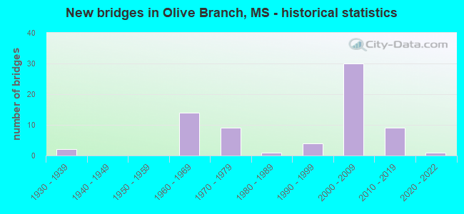
- New bridges - historical statistics
- 21930-1939
- 141960-1969
- 91970-1979
- 11980-1989
- 41990-1999
- 302000-2009
- 92010-2019
- 12020-2022


- Bridge Condition - Deck
- 22.6%Very good
- 41.9%Good
- 19.4%Satisfactory
- 16.1%Fair

- Bridge Condition - Superstructure
- 58.1%Very good
- 32.3%Good
- 3.2%Satisfactory
- 6.5%Fair

- Bridge Condition - Substructure
- 58.1%Very good
- 35.5%Good
- 6.5%Satisfactory

- Bridge Condition - Channel
- 36.4%Very good
- 15.2%Good
- 36.4%Satisfactory
- 9.1%Fair
- 3.0%Poor

- Bridge Condition - Culverts
- 17.6%Very good
- 47.1%Good
- 23.5%Satisfactory
- 11.8%Fair
Find on map >> Show street view
Structure Number: SA1700000000102, Location: SEC 5 T 2S R 6W (Lat: 34.946983, Lng: -89.866150), Route carried "on" structure: City street 7903, Year Built: 2007, Status: Open, Structure Length: 8.54m (28.02ft), Average Daily Traffic: 1,000 (year 2020), Truck Traffic: 8%, Average Future Daily Traffic: 1,500 (year 2040), Design Load: HS 20, Features Intersected: CAMP CREEK, Facility Carried by Structure: CRAFT ROAD
Minimum Vertical Clearance: 30+ m (98+ ft), Kilometerpoint: 1.554, Lanes on structure: 5, Owner: City or Municipal Highway Agency, Approaching Roadway Width: 20.4m (66.9ft), Skew: 4 degrees, Material/Design: Prestressed concrete, Design/Construction: Stringer/Multi-beam, Number Of Spans In Main Unit: 6, Length of Maximum Span: 24.4m (80.1ft), Curb or Sidewalk Widths: Left: 0.4m (1.3ft), Right: 0.4m (1.3ft), Curb-To-Curb Width: 21.0m (68.9ft), Out-to-Out Width: 21.8m (71.5ft)
Condition: Deck: Good, Superstructure: Very good, Substructure: Very good, Channel: Good, Operating Rating: 54.6 metric tons, Method Used To Determine Operating Rating: Load Factor (LF), Inventory Rating: 24.9 metric tons, Method Used To Determine Inventory Rating: Load Factor (LF), Structural Evaluation: Equal to present minimum criteria, Deck Geometry: Somewhat better than minimum adequacy, Waterway Adequacy: Better than present minimum criteria, Approach Roadway Alignment: Equal to present minimum criteria, Designated Inspection Frequency: Every 24 months, Inspection Date: May 2020, Deck Structure Type: Concrete Cast-file-Place, Wearing Surface/Protective System: Wearing Surface: Monolithic Concrete
Find on map >> Show street view
Structure Number: SA1700000000115, Location: SEC 4 T 2S R 6W (Lat: 34.934469, Lng: -89.848075), Route carried "on" structure: City street , Year Built: 2005, Status: Open, Structure Length: 2.80m (9.19ft), Average Daily Traffic: 100 (year 2020), Truck Traffic: 8%, Average Future Daily Traffic: 150 (year 2040), Design Load: HS 20, Features Intersected: LICK CREEK, Facility Carried by Structure: ROSS ROAD
Minimum Vertical Clearance: 30+ m (98+ ft), Kilometerpoint: 0.500, Lanes on structure: 2, Owner: City or Municipal Highway Agency, Approaching Roadway Width: 9.8m (32.2ft), Material/Design: Prestressed concrete, Design/Construction: Stringer/Multi-beam, Number Of Spans In Main Unit: 1, Length of Maximum Span: 28.0m (91.9ft), Curb or Sidewalk Widths: Left: 0.4m (1.3ft), Right: 0.4m (1.3ft), Curb-To-Curb Width: 11.0m (36.1ft), Out-to-Out Width: 15.5m (50.9ft)
Condition: Deck: Very good, Superstructure: Very good, Substructure: Very good, Channel: Very good, Operating Rating: 62.1 metric tons, Method Used To Determine Operating Rating: Load Factor (LF), Inventory Rating: 23.2 metric tons, Method Used To Determine Inventory Rating: Load Factor (LF), Structural Evaluation: Equal to present minimum criteria, Deck Geometry: Superior to present desirable criteria, Waterway Adequacy: Equal to present desirable criteria, Approach Roadway Alignment: Equal to present desirable criteria, Designated Inspection Frequency: Every 24 months, Inspection Date: November 2020, Deck Structure Type: Concrete Cast-file-Place, Wearing Surface/Protective System: Wearing Surface: Monolithic Concrete
Find on map >> Show street view
Structure Number: SA170000000A001, Location: SEC 17 T 1S R 6W B (Lat: 34.991233, Lng: -89.865467), Route carried "on" structure: City street 680, Year Built: 2020, Status: Open, Structure Length: 2.74m (8.99ft), Average Daily Traffic: 3,000 (year 2020), Truck Traffic: 8%, Average Future Daily Traffic: 4,500 (year 2040), Design Load: HL 93, Features Intersected: UNNAMED CREEK, Facility Carried by Structure: STATE LINE ROAD
Minimum Vertical Clearance: 30+ m (98+ ft), Kilometerpoint: 6.759, Lanes on structure: 2, Owner: City or Municipal Highway Agency, Approaching Roadway Width: 11.0m (36.1ft), Skew: 3 degrees, Material/Design: Prestressed concrete, Design/Construction: Stringer/Multi-beam, Number Of Spans In Main Unit: 3, Length of Maximum Span: 9.1m (29.9ft), Curb or Sidewalk Widths: Left: 0.5m (1.6ft), Right: 0.5m (1.6ft), Curb-To-Curb Width: 11.0m (36.1ft), Out-to-Out Width: 12.0m (39.4ft)
Condition: Deck: Very good, Superstructure: Very good, Substructure: Very good, Channel: Very good, Operating Rating: 54.1 metric tons, Method Used To Determine Operating Rating: Load and Resistance Factor Rating (LRFR) rating reported by rating factor(RF) method using HL-93 loadings, Inventory Rating: 32.4 metric tons, Method Used To Determine Inventory Rating: Load and Resistance Factor Rating (LRFR) rating reported by rating factor(RF) method using HL-93 loadings, Structural Evaluation: Equal to present desirable criteria, Deck Geometry: Somewhat better than minimum adequacy, Waterway Adequacy: Equal to present desirable criteria, Approach Roadway Alignment: Equal to present desirable criteria, Designated Inspection Frequency: Every 24 months, Inspection Date: November 2020, Deck Structure Type: Concrete Cast-file-Place, Wearing Surface/Protective System: Wearing Surface: Monolithic Concrete
Find on map >> Show street view
Structure Number: 11002690170237A, Location: I 269 OVER SR 305 (Lat: 34.870550, Lng: -89.830381), Route carried "under" structure: State highway 305, Year Built: 2016, Structure Length: 0. m, Average Daily Traffic: 5,700 (year 2017), Truck Traffic: 10%, Features Intersected: SR 305, Facility Carried by Structure: I 269
Minimum Vertical Clearance: 5.31m (17.42ft), Kilometerpoint: 11.854, Lanes on structure: 2, Lanes under structure: 3, Material/Design: Prestressed concrete continuous, Design/Construction: Stringer/Multi-beam, Length of Maximum Span: 39.0m (128.0ft)
Find on map >> Show street view
Structure Number: 11002690170237B, Location: I 269 OVER SR 305 (Lat: 34.870200, Lng: -89.830350), Route carried "under" structure: State highway 305, Year Built: 2016, Structure Length: 0. m, Average Daily Traffic: 5,700 (year 2017), Truck Traffic: 10%, Features Intersected: SR 305, Facility Carried by Structure: I 269
Minimum Vertical Clearance: 6.48m (21.26ft), Kilometerpoint: 11.816, Lanes on structure: 2, Lanes under structure: 3, Material/Design: Prestressed concrete continuous, Design/Construction: Stringer/Multi-beam, Length of Maximum Span: 39.0m (128.0ft)
Find on map >> Show street view
Structure Number: 21000780170026A, Location: US 78 OVER SR 302 (Lat: 34.962181, Lng: -89.852500), Route carried "under" structure: State highway 302, Year Built: 1967, Structure Length: 0. m, Average Daily Traffic: 35,000 (year 2017), Truck Traffic: 20%, Features Intersected: SR 302, Facility Carried by Structure: US 78
Minimum Vertical Clearance: 4.76m (15.62ft), Kilometerpoint: 26.969, Lanes on structure: 2, Lanes under structure: 5, Material/Design: Concrete continuous, Design/Construction: Box Beam or Girders - Single/Spread, Length of Maximum Span: 27.4m (89.9ft)
Find on map >> Show street view
Structure Number: 21000780170026B, Location: US 78 OVER SR 302 (Lat: 34.962181, Lng: -89.852861), Route carried "under" structure: State highway 302, Year Built: 1967, Structure Length: 0. m, Average Daily Traffic: 35,000 (year 2017), Truck Traffic: 20%, Features Intersected: SR 302, Facility Carried by Structure: US 78
Minimum Vertical Clearance: 4.79m (15.72ft), Kilometerpoint: 26.937, Lanes on structure: 2, Lanes under structure: 5, Material/Design: Concrete continuous, Design/Construction: Box Beam or Girders - Single/Spread, Length of Maximum Span: 27.4m (89.9ft)
Find on map >> Show street view
Structure Number: 21000780170043A, Location: US 78 OVER SR 305 (Lat: 34.945861, Lng: -89.830650), Route carried "under" structure: State highway 305, Year Built: 1967, Structure Length: 0. m, Average Daily Traffic: 9,500 (year 2017), Truck Traffic: 10%, Features Intersected: SR 305, Facility Carried by Structure: US 78
Minimum Vertical Clearance: 4.98m (16.34ft), Kilometerpoint: 0.180, Lanes on structure: 2, Lanes under structure: 4, Material/Design: Prestressed concrete, Design/Construction: Stringer/Multi-beam, Length of Maximum Span: 20.7m (67.9ft)
Find on map >> Show street view
Structure Number: 21000780170043A, Location: US 78 OVER SR 305 (Lat: 34.945769, Lng: -89.830519), Route carried "under" structure: State highway 305, Year Built: 1967, Structure Length: 0. m, Average Daily Traffic: 9,500 (year 2017), Truck Traffic: 10%, Features Intersected: SR 305, Facility Carried by Structure: US 78
Minimum Vertical Clearance: 4.95m (16.24ft), Kilometerpoint: 20.205, Lanes on structure: 2, Lanes under structure: 4, Material/Design: Prestressed concrete, Design/Construction: Stringer/Multi-beam, Length of Maximum Span: 20.7m (67.9ft)
Find on map >> Show street view
Structure Number: 21000780170043B, Location: US 78 OVER SR 305 (Lat: 34.945561, Lng: -89.830669), Route carried "under" structure: State highway 305, Year Built: 1967, Structure Length: 0. m, Average Daily Traffic: 9,500 (year 2017), Truck Traffic: 10%, Features Intersected: SR 305, Facility Carried by Structure: US 78
Minimum Vertical Clearance: 5.15m (16.90ft), Kilometerpoint: 0.214, Lanes on structure: 2, Lanes under structure: 4, Material/Design: Prestressed concrete, Design/Construction: Stringer/Multi-beam, Length of Maximum Span: 20.7m (67.9ft)
Find on map >> Show street view
Structure Number: 21000780170043B, Location: US 78 OVER SR 305 (Lat: 34.945481, Lng: -89.830531), Route carried "under" structure: State highway 305, Year Built: 1967, Structure Length: 0. m, Average Daily Traffic: 9,500 (year 2017), Truck Traffic: 10%, Features Intersected: SR 305, Facility Carried by Structure: US 78
Minimum Vertical Clearance: 5.12m (16.80ft), Kilometerpoint: 20.173, Lanes on structure: 2, Lanes under structure: 4, Material/Design: Prestressed concrete, Design/Construction: Stringer/Multi-beam, Length of Maximum Span: 20.7m (67.9ft)
Find on map >> Show street view
Structure Number: 31003020170181A, Location: 1.1 MI E US 78 (Lat: 34.967450, Lng: -89.835081), Route carried "under" structure: City street , Year Built: 2001, Structure Length: 0. m, Average Daily Traffic: 2,000 (year 2017), Truck Traffic: 3%, Features Intersected: SR178 SR305 BNRR RAMP, Facility Carried by Structure: SR 302
Minimum Vertical Clearance: 5.01m (16.44ft), Kilometerpoint: 1.992, Lanes on structure: 3, Lanes under structure: 10, Material/Design: Steel continuous, Design/Construction: Stringer/Multi-beam, Length of Maximum Span: 64.9m (212.9ft)
Find on map >> Show street view
Structure Number: 31003020170181A, Location: 1.1 MI E US 78 (Lat: 34.967939, Lng: -89.833769), Route carried "under" structure: State highway 178, Year Built: 2001, Structure Length: 0. m, Average Daily Traffic: 7,300 (year 2017), Truck Traffic: 8%, Features Intersected: SR178 SR305 BNRR RAMP, Facility Carried by Structure: SR 302
Minimum Vertical Clearance: 8.24m (27.03ft), Kilometerpoint: 4.612, Lanes on structure: 3, Lanes under structure: 10, Material/Design: Steel continuous, Design/Construction: Stringer/Multi-beam, Length of Maximum Span: 64.9m (212.9ft)
Find on map >> Show street view
Structure Number: 31003020170181A, Location: 1.1 MI E US 78 (Lat: 34.968650, Lng: -89.831350), Route carried "under" structure: Ramp State highway 302, Year Built: 2001, Structure Length: 0. m, Average Daily Traffic: 1,900 (year 2017), Truck Traffic: 8%, Features Intersected: SR178 SR305 BNRR RAMP
Minimum Vertical Clearance: 5.21m (17.09ft), Kilometerpoint: 0.200, Lanes on structure: 3, Lanes under structure: 10, Material/Design: Steel continuous, Design/Construction: Stringer/Multi-beam, Length of Maximum Span: 64.9m (212.9ft)
Find on map >> Show street view
Structure Number: 31003020170181A, Location: 1.1 MI E US 78 (Lat: 34.968831, Lng: -89.830489), Route carried "under" structure: State highway 305, Year Built: 2001, Structure Length: 0. m, Average Daily Traffic: 24,000 (year 2017), Truck Traffic: 14%, Features Intersected: SR178 SR305 BNRR RAMP, Facility Carried by Structure: SR 302
Minimum Vertical Clearance: 6.65m (21.82ft), Kilometerpoint: 22.766, Lanes on structure: 3, Lanes under structure: 10, Material/Design: Steel continuous, Design/Construction: Stringer/Multi-beam, Length of Maximum Span: 64.9m (212.9ft)
Find on map >> Show street view
Structure Number: 31003020170181B, Location: 1.1 MI E US 78 (Lat: 34.968389, Lng: -89.831311), Route carried "under" structure: State highway 302, Year Built: 2001, Structure Length: 0. m, Average Daily Traffic: 1,900 (year 2017), Truck Traffic: 8%, Features Intersected: SR 178 BNRR RAMP D SR305
Minimum Vertical Clearance: 5.30m (17.39ft), Kilometerpoint: 0.227, Lanes on structure: 2, Lanes under structure: 10, Material/Design: Steel continuous, Design/Construction: Stringer/Multi-beam, Length of Maximum Span: 64.9m (212.9ft)
Find on map >> Show street view
Structure Number: 31003020170181B, Location: 1.1 MI E US 78 (Lat: 34.967250, Lng: -89.834839), Route carried "under" structure: City street , Year Built: 2001, Structure Length: 0. m, Average Daily Traffic: 2,000 (year 2017), Truck Traffic: 3%, Features Intersected: SR 178 BNRR RAMP D SR305, Facility Carried by Structure: SR 302
Minimum Vertical Clearance: 5.79m (19.00ft), Kilometerpoint: 1.962, Lanes on structure: 2, Lanes under structure: 10, Material/Design: Steel continuous, Design/Construction: Stringer/Multi-beam, Length of Maximum Span: 64.9m (212.9ft)
Find on map >> Show street view
Structure Number: 31003020170181B, Location: 1.1 MI E US 78 (Lat: 34.967761, Lng: -89.833489), Route carried "under" structure: State highway 178, Year Built: 2001, Structure Length: 0. m, Average Daily Traffic: 7,300 (year 2017), Truck Traffic: 8%, Features Intersected: SR 178 BNRR RAMP D SR305, Facility Carried by Structure: SR 302
Minimum Vertical Clearance: 8.23m (27.00ft), Kilometerpoint: 4.645, Lanes on structure: 2, Lanes under structure: 10, Material/Design: Steel continuous, Design/Construction: Stringer/Multi-beam, Length of Maximum Span: 64.9m (212.9ft)
Find on map >> Show street view
Structure Number: 31003020170181B, Location: 1.1 MI E US 78 (Lat: 34.968569, Lng: -89.830481), Route carried "under" structure: State highway 305, Year Built: 2001, Structure Length: 0. m, Average Daily Traffic: 24,000 (year 2017), Truck Traffic: 14%, Features Intersected: SR 178 BNRR RAMP D SR305, Facility Carried by Structure: SR 302
Minimum Vertical Clearance: 5.15m (16.90ft), Kilometerpoint: 22.737, Lanes on structure: 2, Lanes under structure: 10, Material/Design: Steel continuous, Design/Construction: Stringer/Multi-beam, Length of Maximum Span: 64.9m (212.9ft)
Find on map >> Show street view
Structure Number: 31003050170238, Location: 1.4 MI N US 78 (Lat: 34.967239, Lng: -89.830461), Route carried "under" structure: Ramp State highway 305, Year Built: 2001, Structure Length: 0. m, Average Daily Traffic: 1,900 (year 2017), Truck Traffic: 8%, Features Intersected: SR 178 AND BNRR
Minimum Vertical Clearance: 5.65m (18.54ft), Kilometerpoint: 0.381, Lanes on structure: 4, Lanes under structure: 5, Material/Design: Steel continuous, Design/Construction: Stringer/Multi-beam, Length of Maximum Span: 18.3m (60.0ft)
Find on map >> Show street view
Structure Number: 31003050170238, Location: 1.4 MI N US 78 (Lat: 34.965781, Lng: -89.830439), Route carried "under" structure: State highway 178, Year Built: 2001, Structure Length: 0. m, Average Daily Traffic: 7,300 (year 2017), Truck Traffic: 12%, Features Intersected: SR 178 AND BNRR, Facility Carried by Structure: SR 305
Minimum Vertical Clearance: 4.95m (16.24ft), Kilometerpoint: 5.000, Lanes on structure: 4, Lanes under structure: 5, Material/Design: Steel continuous, Design/Construction: Stringer/Multi-beam, Length of Maximum Span: 18.3m (60.0ft)
Find on map >> Show street view
Structure Number: 41000780170014, Location: 1.4 MI E TENN ST LINE (Lat: 34.976681, Lng: -89.864669), Route carried "under" structure: US 78, Year Built: 1967, Structure Length: 0. m, Average Daily Traffic: 14,500 (year 2017), Truck Traffic: 17%, Features Intersected: US 78, Facility Carried by Structure: CRAFT ROAD
Minimum Vertical Clearance: 5.24m (17.19ft), Kilometerpoint: 15.747, Lanes on structure: 2, Lanes under structure: 4, Material/Design: Concrete continuous, Design/Construction: Box Beam or Girders - Single/Spread, Length of Maximum Span: 28.3m (92.8ft)
Find on map >> Show street view
Structure Number: 41000780170014, Location: 1.4 MI E TENN ST LINE (Lat: 34.976439, Lng: -89.864811), Route carried "under" structure: US 78, Year Built: 1967, Structure Length: 0. m, Average Daily Traffic: 14,500 (year 2017), Truck Traffic: 17%, Features Intersected: US 78, Facility Carried by Structure: CRAFT ROAD
Minimum Vertical Clearance: 4.89m (16.04ft), Kilometerpoint: 2.403, Lanes on structure: 2, Lanes under structure: 4, Material/Design: Concrete continuous, Design/Construction: Box Beam or Girders - Single/Spread, Length of Maximum Span: 28.3m (92.8ft)
Find on map >> Show street view
Structure Number: 41000780170085, Location: 3.4 MI W MARSHALL CL (Lat: 34.914236, Lng: -89.769011), Route carried "under" structure: US 78, Year Built: 1971, Structure Length: 0. m, Average Daily Traffic: 14,500 (year 2017), Truck Traffic: 17%, Features Intersected: US 78, Facility Carried by Structure: MILLER ROAD
Minimum Vertical Clearance: 4.94m (16.21ft), Kilometerpoint: 3.581, Lanes on structure: 2, Lanes under structure: 4, Material/Design: Prestressed concrete, Design/Construction: Stringer/Multi-beam, Length of Maximum Span: 29.3m (96.1ft)
Find on map >> Show street view
Structure Number: 41000780170085, Location: 3.4 MI W MARSHALL CL (Lat: 34.914236, Lng: -89.769011), Route carried "under" structure: US 78, Year Built: 1971, Structure Length: 0. m, Average Daily Traffic: 14,500 (year 2017), Truck Traffic: 17%, Features Intersected: US 78, Facility Carried by Structure: MILLER ROAD
Minimum Vertical Clearance: 5.56m (18.24ft), Kilometerpoint: 3.581, Lanes on structure: 2, Lanes under structure: 4, Material/Design: Prestressed concrete, Design/Construction: Stringer/Multi-beam, Length of Maximum Span: 29.3m (96.1ft)