Bridge Statistics for Ottawa, Illinois (IL)
Condition, Traffic, Stress, Structural Evaluation, Project Costs
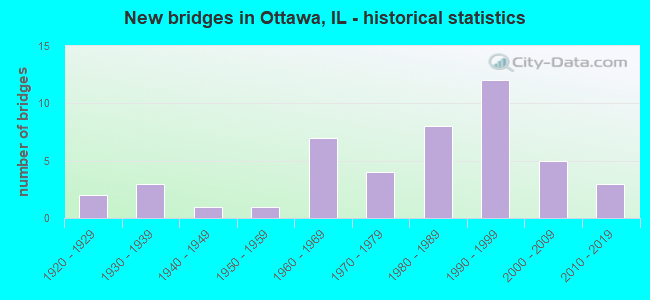
- New bridges - historical statistics
- 21920-1929
- 31930-1939
- 11940-1949
- 11950-1959
- 71960-1969
- 41970-1979
- 81980-1989
- 121990-1999
- 52000-2009
- 32010-2019

- Reconstructed bridges - Historical Statistics
- 21970-1979
- 21980-1989
- 21990-1999


- Bridge Condition - Deck
- 26.5%Very good
- 8.8%Good
- 44.1%Satisfactory
- 11.8%Fair
- 8.8%Poor

- Bridge Condition - Superstructure
- 28.9%Very good
- 21.1%Good
- 31.6%Satisfactory
- 10.5%Fair
- 7.9%Poor

- Bridge Condition - Substructure
- 39.5%Very good
- 36.8%Good
- 7.9%Satisfactory
- 13.2%Fair
- 2.6%Poor

- Bridge Condition - Channel
- 5.7%Excellent
- 45.7%Very good
- 20.0%Good
- 17.1%Satisfactory
- 8.6%Fair
- 2.9%Poor

- Bridge Condition - Culverts
- 25.0%Very good
- 50.0%Good
- 25.0%Satisfactory
Find on map >> Show street view
Structure Number: 507401, Location: 300FT N OF PRAIRIE (Lat: 41.361292, Lng: -88.838128), Route carried "on" structure: City street , Year Built: 1940, Status: Open, Structure Length: 1.52m (4.99ft), Average Daily Traffic: 650 (year 2020), Truck Traffic: 8%, Average Future Daily Traffic: 1,452 (year 2032), Features Intersected: GOOSE CR, Facility Carried by Structure: POST ST
Minimum Vertical Clearance: 30+ m (98+ ft), Kilometerpoint: 0.306, Lanes on structure: 2, Owner: City or Municipal Highway Agency, Approaching Roadway Width: 7.6m (24.9ft), Material/Design: Concrete, Design/Construction: Slab, Number Of Spans In Main Unit: 2, Length of Maximum Span: 7.3m (24.0ft), Curb-To-Curb Width: 7.6m (24.9ft), Out-to-Out Width: 8.0m (26.2ft)
Condition: Deck: Poor, Superstructure: Poor, Substructure: Fair, Channel: Satisfactory, Operating Rating: 32.4 metric tons, Method Used To Determine Operating Rating: Field evaluation and documented engineering judgment, Inventory Rating: 19.4 metric tons, Method Used To Determine Inventory Rating: Field evaluation and documented engineering judgment, Structural Evaluation: Meets minimum limits, Deck Geometry: Meets minimum limits, Waterway Adequacy: Better than present minimum criteria, Approach Roadway Alignment: Equal to present desirable criteria, Designated Inspection Frequency: Every 24 months, Inspection Date: March 2021, Deck Structure Type: Concrete Cast-file-Place, Wearing Surface/Protective System: Wearing Surface: Bituminous
Find on map >> Show street view
Structure Number: 507403, Location: 150 FT E OF IL 23 (Lat: 41.363086, Lng: -88.838875), Route carried "on" structure: City street , Year Built: 1994, Status: Open, Structure Length: 1.45m (4.76ft), Average Daily Traffic: 700 (year 2020), Truck Traffic: 4%, Average Future Daily Traffic: 949 (year 2032), Design Load: HS 20, Features Intersected: GOOSE CREEK, Facility Carried by Structure: POST ST
Minimum Vertical Clearance: 30+ m (98+ ft), Kilometerpoint: 0.048, Lanes on structure: 2, Owner: City or Municipal Highway Agency, Approaching Roadway Width: 7.3m (24.0ft), Skew: 4 degrees, Material/Design: Steel, Design/Construction: Stringer/Multi-beam, Number Of Spans In Main Unit: 1, Length of Maximum Span: 13.5m (44.3ft), Curb or Sidewalk Widths: Left: 1.5m (4.9ft), Right: 0.0m, Curb-To-Curb Width: 7.9m (25.9ft), Out-to-Out Width: 9.8m (32.2ft)
Condition: Deck: Very good, Superstructure: Very good, Substructure: Very good, Channel: Very good, Operating Rating: 44.1 metric tons, Method Used To Determine Operating Rating: Assigned rating based on Load Factor Design (LFD) reported by rating factor (RF) using MS18 loading, Inventory Rating: 32.4 metric tons, Method Used To Determine Inventory Rating: Assigned rating based on Load Factor Design (LFD) reported by rating factor (RF) using MS18 loading, Structural Evaluation: Equal to present desirable criteria, Deck Geometry: Somewhat better than minimum adequacy, Waterway Adequacy: Equal to present desirable criteria, Approach Roadway Alignment: Equal to present desirable criteria, Designated Inspection Frequency: Every 48 months, Inspection Date: September 2018, Deck Structure Type: Concrete Cast-file-Place, Wearing Surface/Protective System: Deck Protection: Epoxy Coated Reinforcing
Find on map >> Show street view
Structure Number: 500129, Location: 6.0 MI E OF ILL 178 (Lat: 41.368269, Lng: -88.893789), Route carried "under" structure: Interstate 80, Year Built: 1962, Structure Length: 0. m, Average Daily Traffic: 30,600 (year 2021), Truck Traffic: 31%, Features Intersected: FAI 80, Facility Carried by Structure: TWP RD TR 244
Minimum Vertical Clearance: 4.72m (15.49ft), Kilometerpoint: 140.428, Lanes on structure: 2, Lanes under structure: 4, Material/Design: Steel continuous, Design/Construction: Stringer/Multi-beam, Length of Maximum Span: 18.0m (59.1ft)
Find on map >> Show street view
Structure Number: 50013, Location: 8.1 MI E OF ILL 178 (Lat: 41.369558, Lng: -88.855364), Route carried "under" structure: Interstate 80, Year Built: 1961, Structure Length: 0. m, Average Daily Traffic: 30,600 (year 2021), Truck Traffic: 31%, Features Intersected: FAI 80, Facility Carried by Structure: TWP RD TR 284
Minimum Vertical Clearance: 4.95m (16.24ft), Kilometerpoint: 143.662, Lanes on structure: 2, Lanes under structure: 4, Material/Design: Steel continuous, Design/Construction: Stringer/Multi-beam, Length of Maximum Span: 19.5m (64.0ft)
Find on map >> Show street view
Structure Number: 500216, Location: ILL 23 AT OTTAWA (Lat: 41.376036, Lng: -88.836078), Route carried "under" structure: Interstate 80, Year Built: 1993, Structure Length: 0. m, Average Daily Traffic: 30,900 (year 2021), Truck Traffic: 28%, Features Intersected: I 80, Facility Carried by Structure: IL 23/FAP 68
Minimum Vertical Clearance: 5.08m (16.67ft), Kilometerpoint: 145.465, Lanes on structure: 4, Lanes under structure: 4, Material/Design: Steel continuous, Design/Construction: Stringer/Multi-beam, Length of Maximum Span: 30.5m (100.1ft)
Find on map >> Show street view
Structure Number: 500222, Location: 7.0 M E OF IL 178 (Lat: 41.368375, Lng: -88.874600), Route carried "under" structure: Interstate 80, Year Built: 1997, Structure Length: 0. m, Average Daily Traffic: 30,600 (year 2021), Truck Traffic: 31%, Features Intersected: I 80, Facility Carried by Structure: FAS 1267/TERRA COT
Minimum Vertical Clearance: 5.08m (16.67ft), Kilometerpoint: 142.037, Lanes on structure: 2, Lanes under structure: 4, Material/Design: Steel continuous, Design/Construction: Stringer/Multi-beam, Length of Maximum Span: 27.0m (88.6ft)