Bridge Statistics for Pawtucket, Rhode Island (RI)
Condition, Traffic, Stress, Structural Evaluation, Project Costs
- National Bridge Inventory (NBI) Statistics
- 56Number of bridges
- 571ft / 174mTotal length
- $122,647,000Total costs
- 2,097,753Total average daily traffic
- 239,542Total average daily truck traffic
- National Bridge Inventory (NBI) Registered Bridges for Pawtucket
- No street view available for this location
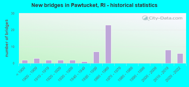
- New bridges - historical statistics
- 2Before 1900
- 31900-1909
- 21910-1919
- 21920-1929
- 21930-1939
- 11940-1949
- 71950-1959
- 231960-1969
- 82010-2019
- 62020-2022

- Reconstructed bridges - Historical Statistics
- 11960-1969
- 21970-1979
- 91980-1989
- 21990-1999
- 92000-2009


- Bridge Condition - Deck
- 16.2%Very good
- 48.6%Good
- 21.6%Satisfactory
- 13.5%Fair

- Bridge Condition - Superstructure
- 16.7%Very good
- 19.0%Good
- 21.4%Satisfactory
- 31.0%Fair
- 9.5%Poor
- 2.4%Serious

- Bridge Condition - Substructure
- 11.9%Very good
- 23.8%Good
- 33.3%Satisfactory
- 26.2%Fair
- 4.8%Poor

- Bridge Condition - Channel
- 23.1%Good
- 38.5%Satisfactory
- 38.5%Fair
Find on map >> Show street view
Structure Number: 965, Location: 0.1 Mi N of George St (Lat: 41.872628, Lng: -71.384517), Route carried "on" structure: City street , Year Built: 1877, Year Reconstructed: 1985, Status: Posted for load, Structure Length: 13.48m (44.23ft), Average Daily Traffic: 14,948 (year 2014), Truck Traffic: 10%, Average Future Daily Traffic: 17,938 (year 2036), Features Intersected: SEEKONK RVR TAFT S, Facility Carried by Structure: DIVISION ST
Minimum Vertical Clearance: 30+ m (98+ ft), Kilometerpoint: 0.267, Lanes on structure: 2, Lanes under structure: 2, Owner: City or Municipal Highway Agency, Approaching Roadway Width: 7.9m (25.9ft), Material/Design: Masonry, Design/Construction: Arch - Deck, Number Of Spans In Main Unit: 9, Length of Maximum Span: 17.3m (56.8ft), Curb or Sidewalk Widths: Left: 1.7m (5.6ft), Right: 1.7m (5.6ft), Curb-To-Curb Width: 7.9m (25.9ft), Out-to-Out Width: 9.0m (29.5ft)
Condition: Deck: Fair, Superstructure: Fair, Substructure: Fair, Channel: Fair, Operating Rating: 74.7 metric tons, Method Used To Determine Operating Rating: Allowable Stress (AS), Inventory Rating: 44.7 metric tons, Method Used To Determine Inventory Rating: Allowable Stress (AS), Structural Evaluation: Somewhat better than minimum adequacy, Deck Geometry: High priority of corrective action, Underclear: Better than present minimum criteria, Waterway Adequacy: Equal to present desirable criteria, Approach Roadway Alignment: Equal to present minimum criteria, Bridge Posting: Required (Relationship of Operating Rating to Maximum Legal Load: 10.0 - 19.9% below), Length Of Structure Improvement: 13.62m (44.69ft), Designated Inspection Frequency: Every 24 months, Underwater Inspection Frequency: Every 48 months, Other Special Inspection Frequency: Every 12 months, Inspection Date: April 2020, Underwater Inspection Date: April 2018, Other Special Inspection Date: March 2021, Bridge Improvement Cost: $6,556,000, Roadway Improvement Cost: $656,000, Total Project Cost: $9,834,000, Deck Structure Type: Concrete Cast-file-Place, Wearing Surface/Protective System: Wearing Surface: Bituminous
Find on map >> Show street view
Structure Number: 966, Location: 0.2 Mi W of JCT I-95 (Lat: 41.876519, Lng: -71.383281), Route carried "on" structure: Business US 1, Year Built: 1858, Year Reconstructed: 1968, Status: Open, Structure Length: 3.32m (10.89ft), Average Daily Traffic: 16,040 (year 2015), Truck Traffic: 2%, Average Future Daily Traffic: 19,248 (year 2036), Features Intersected: BLACKSTONE RIVER, Facility Carried by Structure: MAIN ST
Minimum Vertical Clearance: 30+ m (98+ ft), Kilometerpoint: 49.838, Lanes on structure: 1, Base Highway Network: Yes, Owner: City or Municipal Highway Agency, Approaching Roadway Width: 19.5m (64.0ft), Material/Design: Masonry, Design/Construction: Arch - Deck, Number Of Spans In Main Unit: 2, Length of Maximum Span: 16.2m (53.1ft), Curb or Sidewalk Widths: Left: 0.0m, Right: 3.0m (9.8ft), Curb-To-Curb Width: 4.3m (14.1ft), Out-to-Out Width: 7.3m (24.0ft)
Condition: Superstructure: Fair, Substructure: Fair, Channel: Satisfactory, Structural Evaluation: Somewhat better than minimum adequacy, Deck Geometry: High priority of replacement, Waterway Adequacy: Equal to present desirable criteria, Approach Roadway Alignment: Somewhat better than minimum adequacy, Length Of Structure Improvement: 3.78m (12.40ft), Designated Inspection Frequency: Every 24 months, Underwater Inspection Frequency: Every 48 months, Inspection Date: August 2020, Underwater Inspection Date: August 2020, Bridge Improvement Cost: $1,874,000, Roadway Improvement Cost: $187,000, Total Project Cost: $2,811,000
Find on map >> Show street view
Structure Number: 9662, Location: 0.2 MI. W OF JCT. I-95 (Lat: 41.876422, Lng: -71.383361), Route carried "on" structure: US 1, Year Built: 1968, Status: Open, Structure Length: 3.78m (12.40ft), Average Daily Traffic: 10,100 (year 2006), Truck Traffic: 10%, Average Future Daily Traffic: 12,120 (year 2036), Design Load: HS 20, Features Intersected: BLACKSTONE RIVER, Facility Carried by Structure: MAIN ST
Minimum Vertical Clearance: 30+ m (98+ ft), Kilometerpoint: 89.650, Lanes on structure: 3, Base Highway Network: Yes, Owner: City or Municipal Highway Agency, Approaching Roadway Width: 19.5m (64.0ft), Material/Design: Steel, Design/Construction: Stringer/Multi-beam, Number Of Spans In Main Unit: 1, Length of Maximum Span: 36.0m (118.1ft), Curb or Sidewalk Widths: Left: 0.0m, Right: 5.8m (19.0ft), Curb-To-Curb Width: 12.2m (40.0ft), Out-to-Out Width: 18.0m (59.1ft)
Condition: Deck: Satisfactory, Superstructure: Fair, Substructure: Fair, Channel: Good, Operating Rating: 33.0 metric tons, Method Used To Determine Operating Rating: Load and Resistance Factor Rating (LRFR) rating reported by rating factor(RF) method using HL-93 loadings, Inventory Rating: 25.6 metric tons, Method Used To Determine Inventory Rating: Load and Resistance Factor Rating (LRFR) rating reported by rating factor(RF) method using HL-93 loadings, Structural Evaluation: Somewhat better than minimum adequacy, Deck Geometry: Meets minimum limits, Waterway Adequacy: Superior to present desirable criteria, Approach Roadway Alignment: Better than present minimum criteria, Length Of Structure Improvement: 3.78m (12.40ft), Designated Inspection Frequency: Every 24 months, Underwater Inspection Frequency: Every 48 months, Inspection Date: August 2020, Underwater Inspection Date: August 2020, Bridge Improvement Cost: $2,089,000, Roadway Improvement Cost: $209,000, Total Project Cost: $3,134,000, Deck Structure Type: Concrete Cast-file-Place, Wearing Surface/Protective System: Wearing Surface: Bituminous
Find on map >> Show street view
Structure Number: 968, Location: 0.4 Mi N of JCT I-95 (Lat: 41.888669, Lng: -71.381739), Route carried "on" structure: City street , Year Built: 1910, Year Reconstructed: 1991, Status: Open, Structure Length: 5.76m (18.90ft), Average Daily Traffic: 9,999 (year 2015), Truck Traffic: 10%, Average Future Daily Traffic: 11,999 (year 2036), Features Intersected: BLACKSTONE RIVER, Facility Carried by Structure: ROOSEVELT AV
Minimum Vertical Clearance: 30+ m (98+ ft), Kilometerpoint: 1.342, Lanes on structure: 2, Owner: City or Municipal Highway Agency, Approaching Roadway Width: 9.8m (32.2ft), Material/Design: Concrete, Design/Construction: Arch - Deck, Number Of Spans In Main Unit: 3, Length of Maximum Span: 19.8m (65.0ft), Curb or Sidewalk Widths: Left: 2.7m (8.9ft), Right: 2.7m (8.9ft), Curb-To-Curb Width: 9.8m (32.2ft), Out-to-Out Width: 16.3m (53.5ft)
Condition: Superstructure: Satisfactory, Substructure: Satisfactory, Channel: Satisfactory, Operating Rating: 33.9 metric tons, Method Used To Determine Operating Rating: Load and Resistance Factor (LRFR), Inventory Rating: 26.1 metric tons, Method Used To Determine Inventory Rating: Load and Resistance Factor (LRFR), Structural Evaluation: Equal to present minimum criteria, Deck Geometry: Meets minimum limits, Waterway Adequacy: Superior to present desirable criteria, Approach Roadway Alignment: Equal to present minimum criteria, Length Of Structure Improvement: 5.76m (18.90ft), Designated Inspection Frequency: Every 24 months, Underwater Inspection Frequency: Every 48 months, Inspection Date: June 2020, Underwater Inspection Date: June 2020, Bridge Improvement Cost: $1,954,000, Roadway Improvement Cost: $195,000, Total Project Cost: $2,931,000
Find on map >> Show street view
Structure Number: 969, Location: 1.0 Mi E of JCT US 1A (Lat: 41.874150, Lng: -71.340922), Route carried "on" structure: State highway , Year Built: 1926, Status: Open, Structure Length: 1.52m (4.99ft), Average Daily Traffic: 7,250 (year 2021), Truck Traffic: 4%, Average Future Daily Traffic: 7,975 (year 2041), Features Intersected: TEN MILE RIVER, Facility Carried by Structure: RI 15 ARMSTC BLVD
Minimum Vertical Clearance: 30+ m (98+ ft), Kilometerpoint: 13.325, Lanes on structure: 2, Owner: State Highway Agency, Approaching Roadway Width: 11.0m (36.1ft), Material/Design: Concrete, Design/Construction: Arch - Deck, Number Of Spans In Main Unit: 1, Length of Maximum Span: 15.2m (49.9ft), Curb or Sidewalk Widths: Left: 2.1m (6.9ft), Right: 2.1m (6.9ft), Curb-To-Curb Width: 11.0m (36.1ft), Out-to-Out Width: 16.6m (54.5ft)
Condition: Superstructure: Good, Substructure: Fair, Channel: Fair, Operating Rating: 97.2 metric tons, Method Used To Determine Operating Rating: Load and Resistance Factor Rating (LRFR) rating reported by rating factor(RF) method using HL-93 loadings, Inventory Rating: 97.2 metric tons, Method Used To Determine Inventory Rating: Load and Resistance Factor Rating (LRFR) rating reported by rating factor(RF) method using HL-93 loadings, Structural Evaluation: Somewhat better than minimum adequacy, Deck Geometry: Meets minimum limits, Waterway Adequacy: Superior to present desirable criteria, Approach Roadway Alignment: Equal to present desirable criteria, Length Of Structure Improvement: 1.52m (4.99ft), Designated Inspection Frequency: Every 24 months, Inspection Date: June 2020, Bridge Improvement Cost: $524,000, Roadway Improvement Cost: $52,000, Total Project Cost: $787,000
Find on map >> Show street view
Structure Number: 97, Location: 0.5 Mi E of JCT RI 126 (Lat: 41.877228, Lng: -71.405806), Route carried "on" structure: City street , Year Built: 1967, Status: Posted for load, Structure Length: 1.04m (3.41ft), Average Daily Traffic: 9,765 (year 2015), Truck Traffic: 10%, Average Future Daily Traffic: 11,718 (year 2036), Design Load: HS 20, Features Intersected: MOSHASSUCK RIVER, Facility Carried by Structure: WEEDEN ST
Minimum Vertical Clearance: 30+ m (98+ ft), Kilometerpoint: 1.006, Lanes on structure: 2, Owner: City or Municipal Highway Agency, Approaching Roadway Width: 7.9m (25.9ft), Skew: 1 degrees, Material/Design: Steel, Design/Construction: Stringer/Multi-beam, Number Of Spans In Main Unit: 1, Length of Maximum Span: 9.8m (32.2ft), Curb or Sidewalk Widths: Left: 2.1m (6.9ft), Right: 2.1m (6.9ft), Curb-To-Curb Width: 7.9m (25.9ft), Out-to-Out Width: 12.2m (40.0ft)
Condition: Deck: Good, Superstructure: Poor, Substructure: Satisfactory, Channel: Fair, Operating Rating: 30.8 metric tons, Method Used To Determine Operating Rating: Load and Resistance Factor Rating (LRFR) rating reported by rating factor(RF) method using HL-93 loadings, Inventory Rating: 23.7 metric tons, Method Used To Determine Inventory Rating: Load and Resistance Factor Rating (LRFR) rating reported by rating factor(RF) method using HL-93 loadings, Structural Evaluation: Meets minimum limits, Deck Geometry: High priority of replacement, Waterway Adequacy: Equal to present desirable criteria, Approach Roadway Alignment: Equal to present desirable criteria, Bridge Posting: Required (Relationship of Operating Rating to Maximum Legal Load: 10.0 - 19.9% below), Length Of Structure Improvement: 1.04m (3.41ft), Designated Inspection Frequency: Every 24 months, Other Special Inspection Frequency: Every 12 months, Inspection Date: May 2020, Other Special Inspection Date: May 2021, Bridge Improvement Cost: $191,000, Roadway Improvement Cost: $19,000, Total Project Cost: $287,000, Deck Structure Type: Concrete Cast-file-Place, Wearing Surface/Protective System: Wearing Surface: Bituminous
Find on map >> Show street view
Structure Number: 1551, Location: 0.1 mi N of George st (Lat: 41.873258, Lng: -71.385550), Route carried "on" structure: Interstate 95, Year Built: 2013, Status: Open, Structure Length: 1.79m (5.87ft), Average Daily Traffic: 116,900 (year 2015), Truck Traffic: 1%, Average Future Daily Traffic: 140,280 (year 2036), Design Load: HS 25 or greater, Features Intersected: PLEASANT STREET
Minimum Vertical Clearance: 5.79m (19.00ft), Kilometerpoint: 66.933, Lanes on structure: 8, Lanes under structure: 2, Base Highway Network: Yes, Owner: State Highway Agency, Approaching Roadway Width: 43.3m (142.1ft), Skew: 31 degrees, Material/Design: Prestressed concrete, Design/Construction: Box Beam or Girders - Single/Spread, Number Of Spans In Main Unit: 1, Length of Maximum Span: 16.5m (54.1ft), Curb-To-Curb Width: 43.3m (142.1ft), Out-to-Out Width: 46.4m (152.2ft)
Condition: Deck: Good, Superstructure: Good, Substructure: Good, Operating Rating: 60.6 metric tons, Method Used To Determine Operating Rating: Load and Resistance Factor Rating (LRFR) rating reported by rating factor(RF) method using HL-93 loadings, Inventory Rating: 46.0 metric tons, Method Used To Determine Inventory Rating: Load and Resistance Factor Rating (LRFR) rating reported by rating factor(RF) method using HL-93 loadings, Structural Evaluation: Better than present minimum criteria, Deck Geometry: Equal to present desirable criteria, Underclear: Meets minimum limits, Approach Roadway Alignment: Equal to present desirable criteria, Length Of Structure Improvement: 1.83m (6.00ft), Designated Inspection Frequency: Every 24 months, Inspection Date: June 2020, Deck Structure Type: Concrete Cast-file-Place, Wearing Surface/Protective System: Wearing Surface: Bituminous, Membrane: Epoxy, Deck Protection: Galvanized Reinforcing
Find on map >> Show street view
Structure Number: 544, Location: 2.5 Mi N of JCT RI 146 (Lat: 41.871614, Lng: -71.398361), Route carried "under" structure: Interstate 95, Year Built: 1964, Structure Length: 0. m, Average Daily Traffic: 19,853 (year 2021), Truck Traffic: 4%, Features Intersected: I-95 NB & SB, Facility Carried by Structure: RI 122 LONSDALE AV
Minimum Vertical Clearance: 4.34m (14.24ft), Kilometerpoint: 0.000, Lanes on structure: 2, Lanes under structure: 6, Material/Design: Steel, Design/Construction: Stringer/Multi-beam, Length of Maximum Span: 21.0m (68.9ft)
Find on map >> Show street view
Structure Number: 545, Location: 2.0 Mi N of JCT RI 146 (Lat: 41.872167, Lng: -71.396194), Route carried "under" structure: Interstate 95, Year Built: 1964, Structure Length: 0. m, Average Daily Traffic: 78,500 (year 2008), Truck Traffic: 10%, Features Intersected: I-95 NB & SB, Facility Carried by Structure: SLATER ST
Minimum Vertical Clearance: 4.62m (15.16ft), Kilometerpoint: 0.000, Lanes on structure: 2, Lanes under structure: 6, Material/Design: Prestressed concrete, Design/Construction: Stringer/Multi-beam, Length of Maximum Span: 17.4m (57.1ft)
Find on map >> Show street view
Structure Number: 546, Location: 1.0 Mi S of MASS LINE (Lat: 41.872428, Lng: -71.394586), Route carried "under" structure: Interstate 95, Year Built: 1964, Structure Length: 0. m, Average Daily Traffic: 71,000 (year 2008), Truck Traffic: 10%, Features Intersected: I-95 NB & SB, Facility Carried by Structure: MAIN ST
Minimum Vertical Clearance: 4.32m (14.17ft), Kilometerpoint: 0.000, Lanes on structure: 2, Lanes under structure: 8, Material/Design: Steel, Design/Construction: Stringer/Multi-beam, Length of Maximum Span: 27.1m (88.9ft)
Find on map >> Show street view
Structure Number: 547, Location: 1.1 Mi S of MASS LINE (Lat: 41.873056, Lng: -71.390556), Route carried "under" structure: Interstate 95, Year Built: 1964, Structure Length: 0. m, Average Daily Traffic: 90,000 (year 2008), Truck Traffic: 10%, Features Intersected: I-95 NB & SB, Facility Carried by Structure: GARDEN ST
Minimum Vertical Clearance: 5.13m (16.83ft), Kilometerpoint: 0.000, Lanes on structure: 3, Lanes under structure: 6, Material/Design: Steel, Design/Construction: Stringer/Multi-beam, Length of Maximum Span: 17.7m (58.1ft)
Find on map >> Show street view
Structure Number: 5485, Location: 0.2 Mi S of JCT RI 15 (Lat: 41.873086, Lng: -71.389714), Route carried "under" structure: Interstate 95, Year Built: 2018, Structure Length: 0. m, Average Daily Traffic: 90,000 (year 2008), Truck Traffic: 10%, Features Intersected: I-95 NB & SB, Facility Carried by Structure: PINE ST
Minimum Vertical Clearance: 5.46m (17.91ft), Kilometerpoint: 0.000, Lanes on structure: 3, Lanes under structure: 7, Material/Design: Steel, Design/Construction: Stringer/Multi-beam, Length of Maximum Span: 22.6m (74.1ft)
Find on map >> Show street view
Structure Number: 549, Location: 2.0 Mi N of RI 146 (Lat: 41.873078, Lng: -71.387564), Route carried "under" structure: Interstate 95, Year Built: 1964, Structure Length: 0. m, Average Daily Traffic: 90,000 (year 2008), Truck Traffic: 10%, Features Intersected: I-95 NB & SB, Facility Carried by Structure: GEORGE ST
Minimum Vertical Clearance: 4.40m (14.44ft), Kilometerpoint: 0.000, Lanes on structure: 4, Lanes under structure: 7, Material/Design: Prestressed concrete, Design/Construction: Box Beam or Girders - Multiple, Length of Maximum Span: 26.9m (88.3ft)
Find on map >> Show street view
Structure Number: 555, Location: 0.1 Mi E of BROADWAY INT (Lat: 41.876631, Lng: -71.379436), Route carried "under" structure: Interstate 95, Year Built: 1958, Structure Length: 0. m, Average Daily Traffic: 80,000 (year 2008), Truck Traffic: 10%, Features Intersected: I-95 NB & SB, Facility Carried by Structure: WALCOTT ST
Minimum Vertical Clearance: 5.54m (18.18ft), Kilometerpoint: 0.000, Lanes on structure: 4, Lanes under structure: 7, Material/Design: Steel, Design/Construction: Stringer/Multi-beam, Length of Maximum Span: 20.5m (67.3ft)
Find on map >> Show street view
Structure Number: 556, Location: 0.5 Mi N of SEEKONK RIVER (Lat: 41.878056, Lng: -71.378900), Route carried "under" structure: Interstate 95, Year Built: 1964, Structure Length: 0. m, Average Daily Traffic: 80,000 (year 2008), Truck Traffic: 10%, Features Intersected: I-95 NB & SB, Facility Carried by Structure: UNDERWOOD ST
Minimum Vertical Clearance: 5.69m (18.67ft), Kilometerpoint: 0.000, Lanes on structure: 2, Lanes under structure: 8, Material/Design: Steel, Design/Construction: Stringer/Multi-beam, Length of Maximum Span: 24.4m (80.1ft)
Find on map >> Show street view
Structure Number: 557, Location: 0.4 Mi S of MASS. LINE (Lat: 41.879494, Lng: -71.378161), Route carried "under" structure: Interstate 95, Year Built: 1958, Structure Length: 0. m, Average Daily Traffic: 63,800 (year 2008), Truck Traffic: 10%, Features Intersected: I-95 NB & SB, Facility Carried by Structure: EXCHANGE ST
Minimum Vertical Clearance: 4.93m (16.17ft), Kilometerpoint: 0.000, Lanes on structure: 2, Lanes under structure: 7, Material/Design: Steel, Design/Construction: Stringer/Multi-beam, Length of Maximum Span: 17.8m (58.4ft)
Find on map >> Show street view
Structure Number: 558, Location: 1.0 Mi S of MASS LINE (Lat: 41.882350, Lng: -71.377456), Route carried "under" structure: Interstate 95, Year Built: 1964, Structure Length: 0. m, Average Daily Traffic: 9,700 (year 2021), Truck Traffic: 4%, Features Intersected: I-95 NB & SB, Facility Carried by Structure: US 1 BROADWAY
Minimum Vertical Clearance: 4.75m (15.58ft), Kilometerpoint: 0.000, Lanes on structure: 2, Lanes under structure: 6, Material/Design: Steel, Design/Construction: Stringer/Multi-beam, Length of Maximum Span: 32.9m (107.9ft)
Find on map >> Show street view
Structure Number: 559, Location: 0.1 Mi N of JCT US 1 (Lat: 41.883267, Lng: -71.378089), Route carried "under" structure: Interstate 95, Year Built: 1964, Structure Length: 0. m, Average Daily Traffic: 1,500 (year 2021), Truck Traffic: 3%, Features Intersected: I-95 NB & SB, Facility Carried by Structure: FOUNTAIN ST
Minimum Vertical Clearance: 4.32m (14.17ft), Kilometerpoint: 0.000, Lanes on structure: 2, Lanes under structure: 6, Material/Design: Steel, Design/Construction: Stringer/Multi-beam, Length of Maximum Span: 32.9m (107.9ft)
Find on map >> Show street view
Structure Number: 56, Location: 1.0 Mi S of MASS LINE (Lat: 41.885233, Lng: -71.378622), Route carried "under" structure: Interstate 95, Year Built: 1964, Structure Length: 0. m, Average Daily Traffic: 6,100 (year 2021), Truck Traffic: 2%, Features Intersected: I-95 NB & SB, Facility Carried by Structure: CENTRAL AV
Minimum Vertical Clearance: 4.26m (13.98ft), Kilometerpoint: 0.000, Lanes on structure: 2, Lanes under structure: 7, Material/Design: Steel, Design/Construction: Stringer/Multi-beam, Length of Maximum Span: 22.9m (75.1ft)
Find on map >> Show street view
Structure Number: 5625, Location: 0.3 Mi S of Mass Line (Lat: 41.893022, Lng: -71.377175), Route carried "under" structure: City street , Year Built: 2020, Structure Length: 0. m, Average Daily Traffic: 1,552 (year 2008), Truck Traffic: 3%, Features Intersected: ROOSEVELT AV, Facility Carried by Structure: I-95 NB
Minimum Vertical Clearance: 4.47m (14.67ft), Kilometerpoint: 0.000, Lanes on structure: 3, Lanes under structure: 1, Material/Design: Steel, Design/Construction: Stringer/Multi-beam, Length of Maximum Span: 25.3m (83.0ft)
Find on map >> Show street view
Structure Number: 5627, Location: 0.3 Mi S of Mass Line (Lat: 41.893000, Lng: -71.377481), Route carried "under" structure: City street _, Year Built: 2020, Structure Length: 0. m, Average Daily Traffic: 1,552 (year 2008), Truck Traffic: 3%, Features Intersected: ROOSEVELT AV, Facility Carried by Structure: I-95 SB
Minimum Vertical Clearance: 4.85m (15.91ft), Kilometerpoint: 0.000, Lanes on structure: 3, Lanes under structure: 1, Material/Design: Steel, Design/Construction: Stringer/Multi-beam, Length of Maximum Span: 24.7m (81.0ft)