Bridge Statistics for Philadelphia, Mississippi (MS)
Condition, Traffic, Stress, Structural Evaluation, Project Costs
- National Bridge Inventory (NBI) Statistics
- 49Number of bridges
- 630ft / 192mTotal length
- $2,408,532,000Total costs
- 188,280Total average daily traffic
- 18,779Total average daily truck traffic
- National Bridge Inventory (NBI) Registered Bridges for Philadelphia
- No street view available for this location
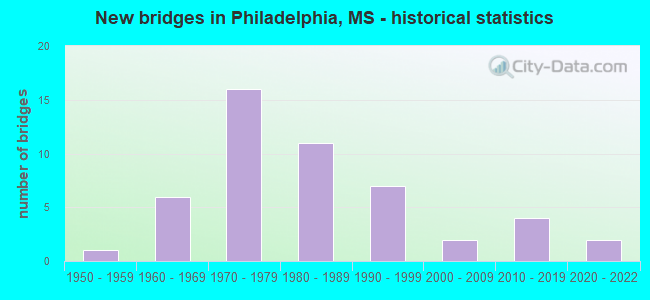
- New bridges - historical statistics
- 11950-1959
- 61960-1969
- 161970-1979
- 111980-1989
- 71990-1999
- 22000-2009
- 42010-2019
- 22020-2022


- Bridge Condition - Deck
- 21.4%Very good
- 42.9%Good
- 17.9%Satisfactory
- 17.9%Fair

- Bridge Condition - Superstructure
- 60.7%Very good
- 14.3%Good
- 10.7%Satisfactory
- 14.3%Fair

- Bridge Condition - Substructure
- 35.7%Very good
- 35.7%Good
- 7.1%Satisfactory
- 14.3%Fair
- 7.1%Poor

- Bridge Condition - Channel
- 2.2%Excellent
- 55.6%Very good
- 15.6%Good
- 15.6%Satisfactory
- 11.1%Fair

- Bridge Condition - Culverts
- 47.4%Very good
- 42.1%Good
- 5.3%Satisfactory
- 5.3%Fair
Find on map >> Show street view
Structure Number: SA500000000A074, Location: SEC 35 T11N R11E (Lat: 32.763583, Lng: -89.139022), Route carried "on" structure: County highway 496, Year Built: 2016, Status: Open, Structure Length: 9.75m (31.99ft), Average Daily Traffic: 1,500 (year 2021), Truck Traffic: 10%, Average Future Daily Traffic: 1,960 (year 2041), Design Load: HL 93, Features Intersected: KENTAWKA CREEK, Facility Carried by Structure: COUNTY ROAD 375
Minimum Vertical Clearance: 30+ m (98+ ft), Kilometerpoint: 1770.000, Lanes on structure: 2, Owner: City or Municipal Highway Agency, Approaching Roadway Width: 7.3m (24.0ft), Skew: 3 degrees, Material/Design: Prestressed concrete, Design/Construction: Stringer/Multi-beam, Number Of Spans In Main Unit: 7, Length of Maximum Span: 24.4m (80.1ft), Curb-To-Curb Width: 9.1m (29.9ft), Out-to-Out Width: 10.0m (32.8ft)
Condition: Deck: Very good, Superstructure: Good, Substructure: Very good, Channel: Satisfactory, Operating Rating: 48.0 metric tons, Method Used To Determine Operating Rating: Load and Resistance Factor Rating (LRFR) rating reported by rating factor(RF) method using HL-93 loadings, Inventory Rating: 33.4 metric tons, Method Used To Determine Inventory Rating: Load and Resistance Factor Rating (LRFR) rating reported by rating factor(RF) method using HL-93 loadings, Structural Evaluation: Better than present minimum criteria, Deck Geometry: Somewhat better than minimum adequacy, Waterway Adequacy: Better than present minimum criteria, Approach Roadway Alignment: Equal to present desirable criteria, Designated Inspection Frequency: Every 24 months, Inspection Date: March 2021, Deck Structure Type: Concrete Cast-file-Place, Wearing Surface/Protective System: Wearing Surface: Monolithic Concrete
Find on map >> Show street view
Structure Number: SA500000000A079, Location: SEC 18 T11N R12E (Lat: 32.799758, Lng: -89.106864), Route carried "on" structure: County highway 573, Year Built: 2016, Status: Open, Structure Length: 3.11m (10.20ft), Average Daily Traffic: 4,700 (year 2021), Truck Traffic: 10%, Average Future Daily Traffic: 6,500 (year 2041), Design Load: HL 93, Features Intersected: BRANCH, Facility Carried by Structure: COUNTY ROAD 561
Minimum Vertical Clearance: 30+ m (98+ ft), Kilometerpoint: 0.000, Lanes on structure: 2, Owner: City or Municipal Highway Agency, Approaching Roadway Width: 7.3m (24.0ft), Material/Design: Concrete, Design/Construction: Channel Beam, Number Of Spans In Main Unit: 1, Number Of Approach Spans: 2, Length of Maximum Span: 12.2m (40.0ft), Curb-To-Curb Width: 9.1m (29.9ft), Out-to-Out Width: 9.9m (32.5ft)
Condition: Deck: Good, Superstructure: Good, Substructure: Good, Channel: Very good, Operating Rating: 43.7 metric tons, Method Used To Determine Operating Rating: Load and Resistance Factor Rating (LRFR) rating reported by rating factor(RF) method using HL-93 loadings, Inventory Rating: 33.7 metric tons, Method Used To Determine Inventory Rating: Load and Resistance Factor Rating (LRFR) rating reported by rating factor(RF) method using HL-93 loadings, Structural Evaluation: Better than present minimum criteria, Deck Geometry: Meets minimum limits, Waterway Adequacy: Equal to present desirable criteria, Approach Roadway Alignment: Equal to present desirable criteria, Designated Inspection Frequency: Every 24 months, Inspection Date: Febuary 2021, Deck Structure Type: Concrete Precast Panels, Wearing Surface/Protective System: Wearing Surface: Monolithic Concrete
Find on map >> Show street view
Structure Number: SA500000000A082, Location: SEC 31 T11N R12E (Lat: 32.757892, Lng: -89.104906), Route carried "on" structure: City street 9580, Year Built: 2021, Status: Open, Structure Length: 1.52m (4.99ft), Average Daily Traffic: 1,650 (year 2021), Truck Traffic: 8%, Average Future Daily Traffic: 2,400 (year 2041), Design Load: HL 93, Features Intersected: CYPRESS BRANCH, Facility Carried by Structure: ST FRANCIS DRIVE
Minimum Vertical Clearance: 30+ m (98+ ft), Kilometerpoint: 0.160, Lanes on structure: 2, Owner: City or Municipal Highway Agency, Approaching Roadway Width: 8.5m (27.9ft), Material/Design: Concrete, Design/Construction: Channel Beam, Number Of Spans In Main Unit: 2, Length of Maximum Span: 9.1m (29.9ft), Curb-To-Curb Width: 8.5m (27.9ft), Out-to-Out Width: 9.3m (30.5ft)
Condition: Deck: Very good, Superstructure: Very good, Substructure: Very good, Channel: Very good, Operating Rating: 43.7 metric tons, Method Used To Determine Operating Rating: Load and Resistance Factor Rating (LRFR) rating reported by rating factor(RF) method using HL-93 loadings, Inventory Rating: 33.7 metric tons, Method Used To Determine Inventory Rating: Load and Resistance Factor Rating (LRFR) rating reported by rating factor(RF) method using HL-93 loadings, Structural Evaluation: Equal to present desirable criteria, Deck Geometry: Somewhat better than minimum adequacy, Waterway Adequacy: Equal to present desirable criteria, Approach Roadway Alignment: Equal to present desirable criteria, Designated Inspection Frequency: Every 24 months, Inspection Date: October 2021, Deck Structure Type: Concrete Precast Panels, Wearing Surface/Protective System: Wearing Surface: Monolithic Concrete
Find on map >> Show street view
Structure Number: 31000150501693, Location: SR15 OVER SR 19 (Lat: 32.809303, Lng: -89.119261), Route carried "under" structure: State highway 19, Year Built: 1975, Structure Length: 0. m, Average Daily Traffic: 1,900 (year 2017), Truck Traffic: 8%, Features Intersected: SR 19, Facility Carried by Structure: SR 15
Minimum Vertical Clearance: 5.24m (17.19ft), Kilometerpoint: 28.435, Lanes on structure: 2, Lanes under structure: 4, Material/Design: Prestressed concrete, Design/Construction: Stringer/Multi-beam, Length of Maximum Span: 29.0m (95.1ft)
Find on map >> Show street view
Structure Number: 31000150501693, Location: SR15 OVER SR 19 (Lat: 32.809303, Lng: -89.119261), Route carried "under" structure: State highway 19, Year Built: 1975, Structure Length: 0. m, Average Daily Traffic: 1,900 (year 2017), Truck Traffic: 8%, Features Intersected: SR 19, Facility Carried by Structure: SR 15
Minimum Vertical Clearance: 4.88m (16.01ft), Kilometerpoint: 28.435, Lanes on structure: 2, Lanes under structure: 4, Material/Design: Prestressed concrete, Design/Construction: Stringer/Multi-beam, Length of Maximum Span: 29.0m (95.1ft)