Bridge Statistics for Pineville, Louisiana (LA)
Condition, Traffic, Stress, Structural Evaluation, Project Costs
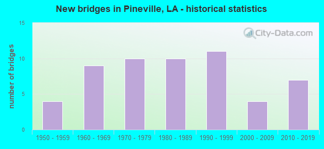
- New bridges - historical statistics
- 41950-1959
- 91960-1969
- 101970-1979
- 101980-1989
- 111990-1999
- 42000-2009
- 72010-2019


- Bridge Condition - Deck
- 2.1%Excellent
- 54.2%Good
- 37.5%Satisfactory
- 6.3%Fair

- Bridge Condition - Superstructure
- 2.1%Excellent
- 50.0%Good
- 37.5%Satisfactory
- 10.4%Fair

- Bridge Condition - Substructure
- 2.1%Excellent
- 64.6%Good
- 16.7%Satisfactory
- 14.6%Fair
- 2.1%Serious

- Bridge Condition - Channel
- 32.4%Good
- 41.2%Satisfactory
- 20.6%Fair
- 5.9%Poor

- Bridge Condition - Culverts
- 57.1%Good
- 28.6%Satisfactory
- 14.3%Serious
Find on map >> Show street view
Structure Number: 84008404000501, Location: INT. LA 3100 & US 167 (Lat: 31.341069, Lng: -92.416700), Route carried "on" structure: State highway 3100, Year Built: 1969, Status: Open, Structure Length: 11.13m (36.52ft), Average Daily Traffic: 2,500 (year 2016), Truck Traffic: 8%, Average Future Daily Traffic: 3,250 (year 2036), Design Load: HS 20, Features Intersected: US 167
Minimum Vertical Clearance: 30+ m (98+ ft), Kilometerpoint: 0.756, Lanes on structure: 2, Lanes under structure: 4, Owner: State Highway Agency, Approaching Roadway Width: 13.4m (44.0ft), Skew: 30 degrees, Material/Design: Prestressed concrete, Design/Construction: Stringer/Multi-beam, Number Of Spans In Main Unit: 4, Length of Maximum Span: 27.7m (90.9ft), Curb-To-Curb Width: 8.5m (27.9ft), Out-to-Out Width: 10.2m (33.5ft)
Condition: Deck: Good, Superstructure: Satisfactory, Substructure: Good, Operating Rating: 84.4 metric tons, Method Used To Determine Operating Rating: Load Factor (LF), Inventory Rating: 50.8 metric tons, Method Used To Determine Inventory Rating: Load Factor (LF), Structural Evaluation: Equal to present minimum criteria, Deck Geometry: Meets minimum limits, Underclear: Equal to present minimum criteria, Approach Roadway Alignment: Equal to present desirable criteria, Designated Inspection Frequency: Every 24 months, Inspection Date: November 2020, Deck Structure Type: Concrete Cast-file-Place, Wearing Surface/Protective System: Wearing Surface: Monolithic Concrete
Find on map >> Show street view
Structure Number: 84008404303061, Location: 2.7 MI. NORTH OF I-49 (Lat: 31.341511, Lng: -92.433000), Route carried "on" structure: US 71, Year Built: 1997, Status: Open, Structure Length: 3.66m (12.01ft), Average Daily Traffic: 12,600 (year 2016), Truck Traffic: 14%, Average Future Daily Traffic: 19,344 (year 2036), Design Load: HS 20, Features Intersected: ROCKY BAYOU
Minimum Vertical Clearance: 30+ m (98+ ft), Kilometerpoint: 4.925, Lanes on structure: 3, Base Highway Network: Yes (Inventory Route: 840-43-1, Subroute: 10), Owner: State Highway Agency, Approaching Roadway Width: 15.9m (52.2ft), Skew: 30 degrees, Material/Design: Concrete, Design/Construction: Slab, Number Of Spans In Main Unit: 6, Length of Maximum Span: 6.1m (20.0ft), Curb-To-Curb Width: 15.7m (51.5ft), Out-to-Out Width: 16.7m (54.8ft)
Condition: Deck: Good, Superstructure: Good, Substructure: Good, Channel: Satisfactory, Operating Rating: 67.1 metric tons, Method Used To Determine Operating Rating: Load Factor (LF), Inventory Rating: 39.9 metric tons, Method Used To Determine Inventory Rating: Load Factor (LF), Structural Evaluation: Better than present minimum criteria, Deck Geometry: Better than present minimum criteria, Waterway Adequacy: Better than present minimum criteria, Approach Roadway Alignment: Equal to present desirable criteria, Designated Inspection Frequency: Every 24 months, Inspection Date: August 2020, Deck Structure Type: Concrete Cast-file-Place, Wearing Surface/Protective System: Wearing Surface: Monolithic Concrete
Find on map >> Show street view
Structure Number: 84008404303062, Location: 2.7 MI. N OF I-49 (Lat: 31.341881, Lng: -92.433000), Route carried "on" structure: US 71, Year Built: 1997, Status: Open, Structure Length: 3.66m (12.01ft), Average Daily Traffic: 12,600 (year 2016), Truck Traffic: 14%, Average Future Daily Traffic: 19,344 (year 2036), Design Load: HS 20, Features Intersected: ROCKY BAYOU
Minimum Vertical Clearance: 30+ m (98+ ft), Kilometerpoint: 4.736, Lanes on structure: 2, Base Highway Network: Yes (Inventory Route: 840-43-2, Subroute: 10), Owner: State Highway Agency, Approaching Roadway Width: 12.2m (40.0ft), Skew: 30 degrees, Material/Design: Concrete, Design/Construction: Slab, Number Of Spans In Main Unit: 6, Length of Maximum Span: 6.1m (20.0ft), Curb-To-Curb Width: 11.1m (36.4ft), Out-to-Out Width: 13.0m (42.7ft)
Condition: Deck: Good, Superstructure: Good, Substructure: Good, Channel: Good, Operating Rating: 66.2 metric tons, Method Used To Determine Operating Rating: Load Factor (LF), Inventory Rating: 39.9 metric tons, Method Used To Determine Inventory Rating: Load Factor (LF), Structural Evaluation: Better than present minimum criteria, Deck Geometry: Equal to present minimum criteria, Waterway Adequacy: Better than present minimum criteria, Approach Roadway Alignment: Equal to present desirable criteria, Designated Inspection Frequency: Every 24 months, Inspection Date: August 2020, Deck Structure Type: Concrete Cast-file-Place, Wearing Surface/Protective System: Wearing Surface: Monolithic Concrete
Find on map >> Show street view
Structure Number: 84031101922791, Location: 0.55 MILE NW OF LA 3265 (Lat: 31.168581, Lng: -92.465400), Route carried "on" structure: County highway , Year Built: 1988, Status: Open, Structure Length: 5.21m (17.09ft), Average Daily Traffic: 25 (year 1976), Average Future Daily Traffic: 32 (year 2036), Design Load: HS 20, Features Intersected: BAYOU CLEAR, Facility Carried by Structure: Coulee Crossing Rd
Minimum Vertical Clearance: 30+ m (98+ ft), Kilometerpoint: 4.463, Lanes on structure: 2, Owner: County Highway Agency, Approaching Roadway Width: 9.8m (32.2ft), Skew: 30 degrees, Material/Design: Concrete, Design/Construction: Slab, Number Of Spans In Main Unit: 9, Length of Maximum Span: 5.8m (19.0ft), Curb-To-Curb Width: 9.8m (32.2ft), Out-to-Out Width: 10.7m (35.1ft)
Condition: Deck: Good, Superstructure: Good, Substructure: Good, Channel: Good, Operating Rating: 49.2 metric tons, Method Used To Determine Operating Rating: Load and Resistance Factor Rating (LRFR) rating reported by rating factor(RF) method using HL-93 loadings, Inventory Rating: 37.9 metric tons, Method Used To Determine Inventory Rating: Load and Resistance Factor Rating (LRFR) rating reported by rating factor(RF) method using HL-93 loadings, Structural Evaluation: Better than present minimum criteria, Deck Geometry: Equal to present desirable criteria, Waterway Adequacy: Better than present minimum criteria, Approach Roadway Alignment: Somewhat better than minimum adequacy, Designated Inspection Frequency: Every 24 months, Underwater Inspection Frequency: Every 60 months, Inspection Date: September 2021, Underwater Inspection Date: May 2018, Deck Structure Type: Concrete Precast Panels, Wearing Surface/Protective System: Wearing Surface: Monolithic Concrete
Find on map >> Show street view
Structure Number: 84031188922611, Location: 0.02 M. N. OF GREER ST. (Lat: 31.313061, Lng: -92.434661), Route carried "on" structure: County highway , Year Built: 1981, Status: Open, Structure Length: 1.19m (3.90ft), Average Daily Traffic: 250 (year 2016), Average Future Daily Traffic: 325 (year 2036), Design Load: HS 20, Features Intersected: HUFFMAN CREEK, Facility Carried by Structure: REMBERT ST
Minimum Vertical Clearance: 30+ m (98+ ft), Kilometerpoint: 0.000, Lanes on structure: 2, Owner: City or Municipal Highway Agency, Approaching Roadway Width: 7.0m (23.0ft), Skew: 30 degrees, Material/Design: Prestressed concrete, Design/Construction: Channel Beam, Number Of Spans In Main Unit: 1, Length of Maximum Span: 11.6m (38.1ft), Curb-To-Curb Width: 8.0m (26.2ft), Out-to-Out Width: 8.4m (27.6ft)
Condition: Deck: Satisfactory, Superstructure: Good, Substructure: Satisfactory, Channel: Good, Operating Rating: 29.5 metric tons, Method Used To Determine Operating Rating: Load and Resistance Factor Rating (LRFR) rating reported by rating factor(RF) method using HL-93 loadings, Inventory Rating: 13.6 metric tons, Method Used To Determine Inventory Rating: Load and Resistance Factor Rating (LRFR) rating reported by rating factor(RF) method using HL-93 loadings, Structural Evaluation: Meets minimum limits, Deck Geometry: Somewhat better than minimum adequacy, Waterway Adequacy: Equal to present minimum criteria, Approach Roadway Alignment: Better than present minimum criteria, Designated Inspection Frequency: Every 24 months, Inspection Date: April 2021, Deck Structure Type: Concrete Precast Panels, Wearing Surface/Protective System: Wearing Surface: Bituminous
Find on map >> Show street view
Structure Number: 84031196922441, Location: 0.2 MI. NORTH OF LA 107 (Lat: 31.327400, Lng: -92.408100), Route carried "on" structure: County highway , Year Built: 1998, Status: Open, Structure Length: 3.05m (10.01ft), Average Daily Traffic: 6,700 (year 1992), Average Future Daily Traffic: 8,710 (year 2036), Design Load: HS 20, Features Intersected: CANAL, Facility Carried by Structure: PINE GROVE DR
Minimum Vertical Clearance: 30+ m (98+ ft), Kilometerpoint: 0.280, Lanes on structure: 2, Owner: City or Municipal Highway Agency, Approaching Roadway Width: 12.2m (40.0ft), Skew: 30 degrees, Material/Design: Concrete, Design/Construction: Slab, Number Of Spans In Main Unit: 5, Length of Maximum Span: 6.1m (20.0ft), Curb-To-Curb Width: 12.3m (40.4ft), Out-to-Out Width: 16.5m (54.1ft)
Condition: Deck: Good, Superstructure: Good, Substructure: Good, Channel: Satisfactory, Operating Rating: 46.0 metric tons, Method Used To Determine Operating Rating: Load and Resistance Factor Rating (LRFR) rating reported by rating factor(RF) method using HL-93 loadings, Inventory Rating: 35.6 metric tons, Method Used To Determine Inventory Rating: Load and Resistance Factor Rating (LRFR) rating reported by rating factor(RF) method using HL-93 loadings, Structural Evaluation: Better than present minimum criteria, Deck Geometry: Somewhat better than minimum adequacy, Waterway Adequacy: Equal to present desirable criteria, Approach Roadway Alignment: Equal to present desirable criteria, Designated Inspection Frequency: Every 24 months, Inspection Date: April 2021, Deck Structure Type: Concrete Cast-file-Place, Wearing Surface/Protective System: Wearing Surface: Monolithic Concrete
Find on map >> Show street view
Structure Number: 84031199922481, Location: 0.05 MI. SOUTH OF LA 28 (Lat: 31.332661, Lng: -92.414300), Route carried "on" structure: County highway , Year Built: 1970, Status: Posted for load, Structure Length: 0.94m (3.08ft), Average Daily Traffic: 200 (year 1980), Average Future Daily Traffic: 260 (year 2036), Design Load: HS 20, Features Intersected: UNNAMED STREAM, Facility Carried by Structure: HEMBLING DR
Minimum Vertical Clearance: 30+ m (98+ ft), Kilometerpoint: 0.080, Lanes on structure: 2, Owner: City or Municipal Highway Agency, Approaching Roadway Width: 8.5m (27.9ft), Skew: 33 degrees, Material/Design: Prestressed concrete, Design/Construction: Channel Beam, Number Of Spans In Main Unit: 1, Length of Maximum Span: 9.4m (30.8ft), Curb-To-Curb Width: 8.9m (29.2ft), Out-to-Out Width: 9.3m (30.5ft)
Condition: Deck: Satisfactory, Superstructure: Satisfactory, Substructure: Fair, Channel: Fair, Operating Rating: 20.1 metric tons, Method Used To Determine Operating Rating: Load and Resistance Factor Rating (LRFR) rating reported by rating factor(RF) method using HL-93 loadings, Inventory Rating: 10.7 metric tons, Method Used To Determine Inventory Rating: Load and Resistance Factor Rating (LRFR) rating reported by rating factor(RF) method using HL-93 loadings, Structural Evaluation: High priority of corrective action, Deck Geometry: Equal to present minimum criteria, Waterway Adequacy: Equal to present minimum criteria, Approach Roadway Alignment: Equal to present minimum criteria, Bridge Posting: Required (Relationship of Operating Rating to Maximum Legal Load: 10.0 - 19.9% below), Designated Inspection Frequency: Every 24 months, Inspection Date: April 2021, Deck Structure Type: Concrete Precast Panels, Wearing Surface/Protective System: Wearing Surface: Bituminous
Find on map >> Show street view
Structure Number: 84031204922631, Location: 0.38 MI. WEST OF US 71 (Lat: 31.340150, Lng: -92.438500), Route carried "on" structure: County highway , Year Built: 2005, Status: Open, Structure Length: 0.70m (2.30ft), Average Daily Traffic: 349 (year 2016), Average Future Daily Traffic: 453 (year 2036), Design Load: HS 20, Features Intersected: BUHLOW LAKE TRIB., Facility Carried by Structure: AIRPORT RD
Minimum Vertical Clearance: 30+ m (98+ ft), Kilometerpoint: 1.720, Lanes on structure: 2, Owner: City or Municipal Highway Agency, Approaching Roadway Width: 6.1m (20.0ft), Skew: 30 degrees, Material/Design: Steel, Design/Construction: Culvert, Number Of Spans In Main Unit: 2, Length of Maximum Span: 3.0m (9.8ft), Curb-To-Curb Width: 6.1m (20.0ft), Out-to-Out Width: 18.3m (60.0ft)
Condition: Channel: Fair, Culverts: Good, Operating Rating: 71.0 metric tons, Method Used To Determine Operating Rating: Load and Resistance Factor Rating (LRFR) rating reported by rating factor(RF) method using HL-93 loadings, Inventory Rating: 54.8 metric tons, Method Used To Determine Inventory Rating: Load and Resistance Factor Rating (LRFR) rating reported by rating factor(RF) method using HL-93 loadings, Structural Evaluation: Better than present minimum criteria, Deck Geometry: Meets minimum limits, Waterway Adequacy: Equal to present desirable criteria, Approach Roadway Alignment: Equal to present desirable criteria, Designated Inspection Frequency: Every 24 months, Inspection Date: July 2021, Deck Structure Type: Other
Find on map >> Show street view
Structure Number: 84031205922551, Location: 0.46 MI. N.OF US 165B (Lat: 31.343489, Lng: -92.429200), Route carried "on" structure: County highway , Year Built: 1983, Status: Open, Structure Length: 2.32m (7.61ft), Average Daily Traffic: 1,422 (year 1990), Average Future Daily Traffic: 1,848 (year 2036), Design Load: HS 20, Features Intersected: CREEK, Facility Carried by Structure: JEFFERSON HWY
Minimum Vertical Clearance: 30+ m (98+ ft), Kilometerpoint: 0.718, Lanes on structure: 2, Owner: City or Municipal Highway Agency, Approaching Roadway Width: 9.8m (32.2ft), Skew: 30 degrees, Material/Design: Concrete, Design/Construction: Slab, Number Of Spans In Main Unit: 4, Length of Maximum Span: 5.8m (19.0ft), Curb-To-Curb Width: 9.9m (32.5ft), Out-to-Out Width: 10.5m (34.4ft)
Condition: Deck: Satisfactory, Superstructure: Satisfactory, Substructure: Fair, Channel: Fair, Operating Rating: 36.9 metric tons, Method Used To Determine Operating Rating: Load and Resistance Factor Rating (LRFR) rating reported by rating factor(RF) method using HL-93 loadings, Inventory Rating: 28.5 metric tons, Method Used To Determine Inventory Rating: Load and Resistance Factor Rating (LRFR) rating reported by rating factor(RF) method using HL-93 loadings, Structural Evaluation: Somewhat better than minimum adequacy, Deck Geometry: Somewhat better than minimum adequacy, Waterway Adequacy: Superior to present desirable criteria, Approach Roadway Alignment: Somewhat better than minimum adequacy, Designated Inspection Frequency: Every 24 months, Inspection Date: April 2021, Deck Structure Type: Concrete Precast Panels, Wearing Surface/Protective System: Wearing Surface: Bituminous
Find on map >> Show street view
Structure Number: 84031207922291, Location: 0.09 M. N. OF SUSEK DRIVE (Lat: 31.345411, Lng: -92.381500), Route carried "on" structure: County highway , Year Built: 1975, Status: Open, Structure Length: 0.76m (2.49ft), Average Daily Traffic: 150 (year 1980), Average Future Daily Traffic: 195 (year 2036), Design Load: HS 20, Features Intersected: BAYOU MARIA TRIB., Facility Carried by Structure: WILDWOOD DR
Minimum Vertical Clearance: 30+ m (98+ ft), Kilometerpoint: 0.145, Lanes on structure: 2, Owner: City or Municipal Highway Agency, Approaching Roadway Width: 8.2m (26.9ft), Skew: 30 degrees, Material/Design: Prestressed concrete, Design/Construction: Channel Beam, Number Of Spans In Main Unit: 1, Length of Maximum Span: 7.6m (24.9ft), Curb-To-Curb Width: 8.6m (28.2ft), Out-to-Out Width: 9.0m (29.5ft)
Condition: Deck: Fair, Superstructure: Fair, Substructure: Fair, Channel: Fair, Operating Rating: 18.1 metric tons, Method Used To Determine Operating Rating: Load and Resistance Factor Rating (LRFR) rating reported by rating factor(RF) method using HL-93 loadings, Inventory Rating: 9.7 metric tons, Method Used To Determine Inventory Rating: Load and Resistance Factor Rating (LRFR) rating reported by rating factor(RF) method using HL-93 loadings, Structural Evaluation: High priority of corrective action, Deck Geometry: Equal to present minimum criteria, Waterway Adequacy: Equal to present minimum criteria, Approach Roadway Alignment: Equal to present minimum criteria, Designated Inspection Frequency: Every 24 months, Inspection Date: April 2021, Deck Structure Type: Concrete Precast Panels, Wearing Surface/Protective System: Wearing Surface: Monolithic Concrete
Find on map >> Show street view
Structure Number: 84031213922551, Location: 0.17 MI. NW US 165 (Lat: 31.354161, Lng: -92.425600), Route carried "on" structure: County highway , Year Built: 2002, Status: Open, Structure Length: 3.02m (9.91ft), Average Daily Traffic: 150 (year 1999), Average Future Daily Traffic: 195 (year 2036), Design Load: HS 20, Features Intersected: BAYOU RIGOLETTE TRIB., Facility Carried by Structure: Myland Dr
Minimum Vertical Clearance: 30+ m (98+ ft), Kilometerpoint: 0.288, Lanes on structure: 2, Owner: County Highway Agency, Approaching Roadway Width: 7.3m (24.0ft), Material/Design: Concrete, Design/Construction: Slab, Number Of Spans In Main Unit: 5, Length of Maximum Span: 6.1m (20.0ft), Curb-To-Curb Width: 7.2m (23.6ft), Out-to-Out Width: 8.2m (26.9ft)
Condition: Deck: Satisfactory, Superstructure: Satisfactory, Substructure: Satisfactory, Channel: Satisfactory, Operating Rating: 33.4 metric tons, Method Used To Determine Operating Rating: Load and Resistance Factor Rating (LRFR) rating reported by rating factor(RF) method using HL-93 loadings, Inventory Rating: 25.9 metric tons, Method Used To Determine Inventory Rating: Load and Resistance Factor Rating (LRFR) rating reported by rating factor(RF) method using HL-93 loadings, Structural Evaluation: Equal to present minimum criteria, Deck Geometry: Meets minimum limits, Waterway Adequacy: Equal to present desirable criteria, Approach Roadway Alignment: Equal to present desirable criteria, Designated Inspection Frequency: Every 24 months, Inspection Date: July 2021, Deck Structure Type: Concrete Cast-file-Place, Wearing Surface/Protective System: Wearing Surface: Monolithic Concrete
Find on map >> Show street view
Structure Number: 84031216922361, Location: 0.25 MI. EAST OF LA 3144 (Lat: 31.351481, Lng: -92.401700), Route carried "on" structure: County highway , Year Built: 1993, Status: Open, Structure Length: 1.16m (3.81ft), Average Daily Traffic: 3,220 (year 1991), Average Future Daily Traffic: 4,186 (year 2036), Design Load: HS 20, Features Intersected: BAYOU MARIA, Facility Carried by Structure: Donahue Ferry Rd
Minimum Vertical Clearance: 30+ m (98+ ft), Kilometerpoint: 1.629, Lanes on structure: 2, Owner: City or Municipal Highway Agency, Approaching Roadway Width: 7.9m (25.9ft), Skew: 30 degrees, Material/Design: Steel, Design/Construction: Culvert, Number Of Spans In Main Unit: 4, Length of Maximum Span: 2.1m (6.9ft)
Condition: Channel: Poor, Culverts: Serious, Operating Rating: 97.2 metric tons, Method Used To Determine Operating Rating: Load and Resistance Factor Rating (LRFR) rating reported by rating factor(RF) method using HL-93 loadings, Inventory Rating: 74.5 metric tons, Method Used To Determine Inventory Rating: Load and Resistance Factor Rating (LRFR) rating reported by rating factor(RF) method using HL-93 loadings, Structural Evaluation: High priority of corrective action, Waterway Adequacy: Equal to present desirable criteria, Approach Roadway Alignment: Equal to present desirable criteria, Designated Inspection Frequency: Every 24 months, Other Special Inspection Frequency: Every 12 months, Inspection Date: September 2021
Find on map >> Show street view
Structure Number: 84031226921921, Location: 1.0 MI. NORTH OF LA 28 (Lat: 31.377131, Lng: -92.321200), Route carried "on" structure: County highway , Year Built: 1979, Status: Posted for load, Structure Length: 1.95m (6.40ft), Average Daily Traffic: 220 (year 1976), Average Future Daily Traffic: 286 (year 2036), Design Load: HS 20, Features Intersected: FLAGON BAYOU, Facility Carried by Structure: Libuse Cut-off Rd
Minimum Vertical Clearance: 30+ m (98+ ft), Kilometerpoint: 2.565, Lanes on structure: 2, Owner: County Highway Agency, Approaching Roadway Width: 9.1m (29.9ft), Skew: 30 degrees, Material/Design: Prestressed concrete, Design/Construction: Channel Beam, Number Of Spans In Main Unit: 3, Length of Maximum Span: 6.4m (21.0ft), Curb-To-Curb Width: 7.2m (23.6ft), Out-to-Out Width: 7.6m (24.9ft)
Condition: Deck: Satisfactory, Superstructure: Satisfactory, Substructure: Serious, Channel: Fair, Operating Rating: 12.0 metric tons, Method Used To Determine Operating Rating: Load and Resistance Factor Rating (LRFR) rating reported by rating factor(RF) method using HL-93 loadings, Inventory Rating: 9.4 metric tons, Method Used To Determine Inventory Rating: Load and Resistance Factor Rating (LRFR) rating reported by rating factor(RF) method using HL-93 loadings, Structural Evaluation: High priority of corrective action, Deck Geometry: Meets minimum limits, Waterway Adequacy: Somewhat better than minimum adequacy, Approach Roadway Alignment: Somewhat better than minimum adequacy, Bridge Posting: Required (Relationship of Operating Rating to Maximum Legal Load: > 39.9% below), Designated Inspection Frequency: Every 24 months, Other Special Inspection Frequency: Every 6 months, Inspection Date: April 2021, Other Special Inspection Date: October 2021, Deck Structure Type: Concrete Cast-file-Place, Wearing Surface/Protective System: Wearing Surface: Monolithic Concrete
Find on map >> Show street view
Structure Number: 84031237922061, Location: 1.67 MI. NE OF LA 116 (Lat: 31.394569, Lng: -92.343900), Route carried "on" structure: County highway , Year Built: 2005, Status: Open, Structure Length: 2.44m (8.01ft), Average Daily Traffic: 600 (year 2002), Average Future Daily Traffic: 780 (year 2036), Design Load: HS 20, Features Intersected: LITTLE CREEK, Facility Carried by Structure: Upr Donahue Fer Rd
Minimum Vertical Clearance: 30+ m (98+ ft), Kilometerpoint: 2.673, Lanes on structure: 2, Owner: County Highway Agency, Approaching Roadway Width: 5.5m (18.0ft), Skew: 30 degrees, Material/Design: Concrete, Design/Construction: Slab, Number Of Spans In Main Unit: 4, Length of Maximum Span: 6.1m (20.0ft), Curb-To-Curb Width: 8.4m (27.6ft), Out-to-Out Width: 9.3m (30.5ft)
Condition: Deck: Good, Superstructure: Good, Substructure: Good, Channel: Good, Operating Rating: 42.1 metric tons, Method Used To Determine Operating Rating: Load and Resistance Factor Rating (LRFR) rating reported by rating factor(RF) method using HL-93 loadings, Inventory Rating: 32.4 metric tons, Method Used To Determine Inventory Rating: Load and Resistance Factor Rating (LRFR) rating reported by rating factor(RF) method using HL-93 loadings, Structural Evaluation: Better than present minimum criteria, Deck Geometry: Somewhat better than minimum adequacy, Waterway Adequacy: Equal to present minimum criteria, Approach Roadway Alignment: Better than present minimum criteria, Designated Inspection Frequency: Every 24 months, Inspection Date: April 2021, Deck Structure Type: Concrete Cast-file-Place, Wearing Surface/Protective System: Wearing Surface: Monolithic Concrete
Find on map >> Show street view
Structure Number: 84031242921991, Location: 2.2 MI. NE OF LA 116 (Lat: 31.403461, Lng: -92.332600), Route carried "on" structure: County highway , Year Built: 1970, Status: Open, Structure Length: 1.16m (3.81ft), Average Daily Traffic: 30 (year 1976), Average Future Daily Traffic: 39 (year 2036), Design Load: HS 20, Features Intersected: BEAVER CREEK, Facility Carried by Structure: Grandpierre Rd
Minimum Vertical Clearance: 30+ m (98+ ft), Kilometerpoint: 0.624, Lanes on structure: 2, Owner: County Highway Agency, Approaching Roadway Width: 6.1m (20.0ft), Skew: 30 degrees, Material/Design: Prestressed concrete, Design/Construction: Channel Beam, Number Of Spans In Main Unit: 2, Length of Maximum Span: 5.8m (19.0ft), Curb-To-Curb Width: 6.6m (21.7ft), Out-to-Out Width: 7.0m (23.0ft)
Condition: Deck: Satisfactory, Superstructure: Satisfactory, Substructure: Satisfactory, Channel: Satisfactory, Operating Rating: 46.3 metric tons, Method Used To Determine Operating Rating: Load Factor (LF), Inventory Rating: 19.0 metric tons, Method Used To Determine Inventory Rating: Load Factor (LF), Structural Evaluation: Somewhat better than minimum adequacy, Deck Geometry: Somewhat better than minimum adequacy, Waterway Adequacy: Equal to present minimum criteria, Approach Roadway Alignment: Somewhat better than minimum adequacy, Designated Inspection Frequency: Every 24 months, Inspection Date: April 2021, Deck Structure Type: Concrete Precast Panels, Wearing Surface/Protective System: Wearing Surface: Monolithic Concrete
Find on map >> Show street view
Structure Number: 84000150103711, Location: 0.27 MI S OF US 165 (Lat: 31.355981, Lng: -92.413539), Route carried "under" structure: US 165, Structure Length: 0. m, Average Daily Traffic: 15,700 (year 2014), Features Intersected: US 167 EXP WAY NB UNDER, Facility Carried by Structure: US 167 EXP WAY
Minimum Vertical Clearance: 5.12m (16.80ft), Kilometerpoint: 9.307, Lanes on structure: 2, Length of Maximum Span: 0.0m
Find on map >> Show street view
Structure Number: 84000150103711, Location: 0.27 MI S OF US 165 (Lat: 31.355750, Lng: -92.413731), Route carried "under" structure: US 165, Structure Length: 0. m, Average Daily Traffic: 15,700 (year 2014), Features Intersected: US 167 SB UNDER US 165 B, Facility Carried by Structure: US 167 EXP WAY
Minimum Vertical Clearance: 5.18m (16.99ft), Kilometerpoint: 9.918, Lanes on structure: 2, Length of Maximum Span: 0.0m
Find on map >> Show street view
Structure Number: 84000230102741, Location: 0.01 MI FROM SERVICE RD (Lat: 31.318900, Lng: -92.429361), Route carried "under" structure: ServiceUS 167, Structure Length: 0. m, Average Daily Traffic: 770 (year 2016), Features Intersected: US 167 NB SERVICE RD / E
Minimum Vertical Clearance: 5.18m (16.99ft), Kilometerpoint: 0.021, Lanes on structure: 2, Lanes under structure: 1, Length of Maximum Span: 0.0m
Find on map >> Show street view
Structure Number: 84000230102741, Location: 0.01 MI E OF US 167 SB (Lat: 31.319319, Lng: -92.429919), Route carried "under" structure: State highway 1250, Structure Length: 0. m, Average Daily Traffic: 2,700 (year 2016), Features Intersected: LA 1250 / WADLEY ST UNDE
Minimum Vertical Clearance: 4.79m (15.72ft), Kilometerpoint: 1.110, Lanes on structure: 2, Lanes under structure: 2, Length of Maximum Span: 0.0m
Find on map >> Show street view
Structure Number: 84000230102742, Location: 0.02 MI FROM SERVICE RD (Lat: 31.318781, Lng: -92.429181), Route carried "under" structure: ServiceUS 167, Structure Length: 0. m, Average Daily Traffic: 770 (year 2016), Features Intersected: US 167 NB SERVICE RD/EXP
Minimum Vertical Clearance: 5.24m (17.19ft), Kilometerpoint: 0.043, Lanes on structure: 2, Lanes under structure: 1, Length of Maximum Span: 0.0m
Find on map >> Show street view
Structure Number: 84000230102742, Location: 0.01 MI E OF US 167 (Lat: 31.320631, Lng: -92.425931), Route carried "under" structure: State highway 1250, Structure Length: 0. m, Average Daily Traffic: 2,700 (year 2016), Features Intersected: US 167 OVER LA 1250
Minimum Vertical Clearance: 5.18m (16.99ft), Kilometerpoint: 1.088, Lanes on structure: 2, Lanes under structure: 2, Length of Maximum Span: 0.0m
Find on map >> Show street view
Structure Number: 84000230103461, Location: 0.01 MI W OF US 167 (Lat: 31.324731, Lng: -92.421381), Route carried "under" structure: State highway 107, Structure Length: 0. m, Average Daily Traffic: 15,400 (year 2016), Features Intersected: LA 107 NB UNDER US 167 N
Minimum Vertical Clearance: 5.03m (16.50ft), Kilometerpoint: 21.472, Lanes on structure: 2, Lanes under structure: 2, Length of Maximum Span: 0.0m
Find on map >> Show street view
Structure Number: 84000230103461, Location: 0.1 MI W OF COTTON ST (Lat: 31.326531, Lng: -92.419931), Route carried "under" structure: ServiceUS 167, Structure Length: 0. m, Average Daily Traffic: 4,640 (year 2016), Features Intersected: US 167 SERVICE RD UNDER
Minimum Vertical Clearance: 4.79m (15.72ft), Kilometerpoint: 0.441, Lanes on structure: 2, Lanes under structure: 2, Length of Maximum Span: 0.0m
Find on map >> Show street view
Structure Number: 84000230103461, Location: 0.01 MI W OF US 167 (Lat: 31.325011, Lng: -92.421661), Route carried "under" structure: State highway 107, Structure Length: 0. m, Average Daily Traffic: 15,400 (year 2016), Features Intersected: LA 107 SB UNDER US 167 N
Minimum Vertical Clearance: 4.79m (15.72ft), Kilometerpoint: 0.043, Lanes on structure: 2, Lanes under structure: 2, Length of Maximum Span: 0.0m
Find on map >> Show street view
Structure Number: 84000230103462, Location: 0.01 MI W OF US 167 (Lat: 31.325011, Lng: -92.421669), Route carried "under" structure: State highway 107, Structure Length: 0. m, Average Daily Traffic: 15,400 (year 2016), Features Intersected: LA 107 SB UNDER US 167 S
Minimum Vertical Clearance: 4.79m (15.72ft), Kilometerpoint: 0.013, Lanes on structure: 2, Lanes under structure: 2, Length of Maximum Span: 0.0m
Find on map >> Show street view
Structure Number: 84000230103462, Location: 0.01 MI W OF US 167 (Lat: 31.325000, Lng: -92.421589), Route carried "under" structure: State highway 107, Structure Length: 0. m, Average Daily Traffic: 15,400 (year 2016), Features Intersected: LA 107 NB UNDER US 167 S
Minimum Vertical Clearance: 5.03m (16.50ft), Kilometerpoint: 21.498, Lanes on structure: 2, Lanes under structure: 2, Length of Maximum Span: 0.0m
Find on map >> Show street view
Structure Number: 84000230103462, Location: 0.1 MI W OF COTTON ST (Lat: 31.326750, Lng: -92.419989), Route carried "under" structure: ServiceUS 167, Structure Length: 0. m, Average Daily Traffic: 4,640 (year 2016), Features Intersected: US 167 SERVICE RD UNDER
Minimum Vertical Clearance: 5.18m (16.99ft), Kilometerpoint: 0.417, Lanes on structure: 2, Lanes under structure: 2, Length of Maximum Span: 0.0m
Find on map >> Show street view
Structure Number: 84000230104091, Location: 0.1 MI W OF US 167 (Lat: 31.333539, Lng: -92.416211), Route carried "under" structure: State highway 28, Structure Length: 0. m, Average Daily Traffic: 18,700 (year 2016), Features Intersected: LA 28 WB under US 167
Minimum Vertical Clearance: 5.21m (17.09ft), Kilometerpoint: 8.489, Lanes on structure: 2, Lanes under structure: 2, Length of Maximum Span: 0.0m
Find on map >> Show street view
Structure Number: 84000230104091, Location: 0.1 MI E OF LA 3100 (Lat: 31.333539, Lng: -92.416211), Route carried "under" structure: State highway 28, Structure Length: 0. m, Average Daily Traffic: 18,700 (year 2016), Features Intersected: LA 28 EB UNDER US 167 NB
Minimum Vertical Clearance: 5.18m (16.99ft), Kilometerpoint: 0.161, Lanes on structure: 2, Lanes under structure: 2, Length of Maximum Span: 0.0m
Find on map >> Show street view
Structure Number: 84000230104092, Location: 0.1 MI E OF LA 3100 (Lat: 31.333519, Lng: -92.416411), Route carried "under" structure: State highway 28, Structure Length: 0. m, Average Daily Traffic: 18,700 (year 2016), Features Intersected: LA 28 EB UNDER US 167 SB
Minimum Vertical Clearance: 5.12m (16.80ft), Kilometerpoint: 0.142, Lanes on structure: 2, Lanes under structure: 2, Length of Maximum Span: 0.0m
Find on map >> Show street view
Structure Number: 84000230104092, Location: 0.1 MI W US 167 OFF RAMP (Lat: 31.333519, Lng: -92.416411), Route carried "under" structure: US 28, Structure Length: 0. m, Average Daily Traffic: 18,700 (year 2016), Features Intersected: LA 28 WB UNDER US 167 SB
Minimum Vertical Clearance: 5.15m (16.90ft), Kilometerpoint: 8.509, Lanes on structure: 2, Lanes under structure: 2, Length of Maximum Span: 0.0m
Find on map >> Show street view
Structure Number: 84000230106031, Location: 1.5 M N of US 71 (Lat: 31.359319, Lng: -92.415969), Route carried "under" structure: US 165, Structure Length: 0. m, Average Daily Traffic: 38,500 (year 2014), Features Intersected: US 165 NB UNDER US 167 N
Minimum Vertical Clearance: 5.09m (16.70ft), Kilometerpoint: 0.678, Lanes on structure: 2, Length of Maximum Span: 0.0m
Find on map >> Show street view
Structure Number: 84000230106031, Location: 0.4 M S of La 1254 (Lat: 31.359600, Lng: -92.415919), Route carried "under" structure: US 165, Structure Length: 0. m, Average Daily Traffic: 38,500 (year 2014), Features Intersected: US 165 SB UNDER US 167 N
Minimum Vertical Clearance: 4.66m (15.29ft), Kilometerpoint: 2.607, Lanes on structure: 2, Length of Maximum Span: 0.0m
Find on map >> Show street view
Structure Number: 84000230106032, Location: 0.4 MI S OF LA 1254 (Lat: 31.359411, Lng: -92.416161), Route carried "under" structure: US 165, Structure Length: 0. m, Average Daily Traffic: 38,500 (year 2014), Features Intersected: US 165 SB UNDER US 167 S
Minimum Vertical Clearance: 4.51m (14.80ft), Kilometerpoint: 2.570, Lanes on structure: 2, Length of Maximum Span: 0.0m
Find on map >> Show street view
Structure Number: 84000230106032, Location: 1.4 MI N OF US 71 (Lat: 31.359150, Lng: -92.416119), Route carried "under" structure: US 165, Structure Length: 0. m, Average Daily Traffic: 38,500 (year 2014), Features Intersected: US 165 NB UNDER US 167 S
Minimum Vertical Clearance: 4.88m (16.01ft), Kilometerpoint: 0.705, Lanes on structure: 2, Length of Maximum Span: 0.0m
Find on map >> Show street view
Structure Number: 84008403400141, Location: 1.3 MI N OF LA 28 (Lat: 31.351311, Lng: -92.411561), Route carried "under" structure: US 167, Structure Length: 0. m, Average Daily Traffic: 14,450 (year 2016), Features Intersected: US 167 NB UNDER LA 3144
Minimum Vertical Clearance: 5.24m (17.19ft), Kilometerpoint: 8.745, Lanes on structure: 2, Lanes under structure: 2, Length of Maximum Span: 0.0m
Find on map >> Show street view
Structure Number: 84008403400141, Location: 0.6 MI S OF US 165 (Lat: 31.351439, Lng: -92.411831), Route carried "under" structure: US 167, Structure Length: 0. m, Average Daily Traffic: 14,450 (year 2016), Features Intersected: US 167 SB UNER LA 3144
Minimum Vertical Clearance: 5.24m (17.19ft), Kilometerpoint: 10.440, Lanes on structure: 2, Lanes under structure: 2, Length of Maximum Span: 0.0m
Find on map >> Show street view
Structure Number: 84008404000501, Location: 0.7 MI N OF LA 31144 (Lat: 31.341389, Lng: -92.416461), Route carried "under" structure: US 167, Structure Length: 0. m, Average Daily Traffic: 15,800 (year 2016), Features Intersected: US 167 NB UNDER DONAHUE
Minimum Vertical Clearance: 5.06m (16.60ft), Kilometerpoint: 11.669, Lanes on structure: 2, Lanes under structure: 2, Length of Maximum Span: 0.0m
Find on map >> Show street view
Structure Number: 84008404000501, Location: 0.5 MI N OF LA 28 (Lat: 31.341389, Lng: -92.416461), Route carried "under" structure: US 167, Structure Length: 0. m, Average Daily Traffic: 15,800 (year 2016), Features Intersected: US 167 NB UNDER DONAHUE
Minimum Vertical Clearance: 5.00m (16.40ft), Kilometerpoint: 7.541, Lanes on structure: 2, Lanes under structure: 2, Length of Maximum Span: 0.0m