Bridge Statistics for Powder Springs, Georgia (GA)
Condition, Traffic, Stress, Structural Evaluation, Project Costs
- National Bridge Inventory (NBI) Statistics
- 44Number of bridges
- 502ft / 153mTotal length
- $52,483,000Total costs
- 451,269Total average daily traffic
- 7,169Total average daily truck traffic
- National Bridge Inventory (NBI) Registered Bridges for Powder Springs
- No street view available for this location
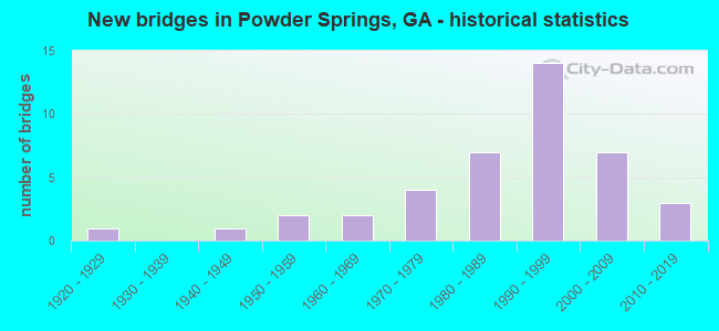
- New bridges - historical statistics
- 11920-1929
- 11940-1949
- 21950-1959
- 21960-1969
- 41970-1979
- 71980-1989
- 141990-1999
- 72000-2009
- 32010-2019

- Reconstructed bridges - Historical Statistics
- 11980-1989
- 41990-1999


- Bridge Condition - Deck
- 10.0%Very good
- 83.3%Good
- 6.7%Satisfactory

- Bridge Condition - Superstructure
- 50.0%Very good
- 46.7%Good
- 3.3%Satisfactory

- Bridge Condition - Substructure
- 6.7%Very good
- 90.0%Good
- 3.3%Satisfactory

- Bridge Condition - Channel
- 5.6%Excellent
- 27.8%Very good
- 38.9%Good
- 19.4%Satisfactory
- 8.3%Fair
Find on map >> Show street view
Structure Number: 670188, Location: 1.6 MI E OF PAULDING CL (Lat: 33.865069, Lng: -84.696969), Route carried "under" structure: County highway 4516, Structure Length: 0. m, Average Daily Traffic: 7,000 (year 1999), Truck Traffic: 1%, Features Intersected: SR 6 (US 278), Facility Carried by Structure: US 278 / SR 6
Minimum Vertical Clearance: 9.24m (30.31ft), Kilometerpoint: 3.219, Lanes on structure: 4, Length of Maximum Span: 0.0m
Find on map >> Show street view
Structure Number: 67525, Location: 1 MILE WEST OF POWDER SPR (Lat: 33.868800, Lng: -84.696839), Route carried "under" structure: US 278, Structure Length: 0. m, Average Daily Traffic: 33,920 (year 2012), Truck Traffic: 1%, Features Intersected: US 278 / SR 6, Facility Carried by Structure: SILVER COMET TRAIL
Minimum Vertical Clearance: 5.18m (16.99ft), Kilometerpoint: 3.219, Length of Maximum Span: 0.0m
Find on map >> Show street view
Structure Number: 675293, Location: 3.2 MILES WEST OF POWDER (Lat: 33.865586, Lng: -84.685319), Route carried "under" structure: County highway 924, Structure Length: 0. m, Average Daily Traffic: 1,930 (year 2012), Truck Traffic: 1%, Features Intersected: OLD LOST MOUNTAIN ROAD, Facility Carried by Structure: SILVER COMET TRAIL
Minimum Vertical Clearance: 5.66m (18.57ft), Kilometerpoint: 1.609, Length of Maximum Span: 0.0m