Bridge Statistics for Richland, Mississippi (MS)
Condition, Traffic, Stress, Structural Evaluation, Project Costs
- National Bridge Inventory (NBI) Statistics
- 49Number of bridges
- 1,168ft / 356mTotal length
- $3,125,341,000Total costs
- 957,930Total average daily traffic
- 124,873Total average daily truck traffic
- National Bridge Inventory (NBI) Registered Bridges for Richland
- No street view available for this location
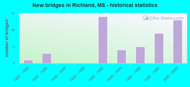
- New bridges - historical statistics
- 11920-1929
- 31930-1939
- 141960-1969
- 41970-1979
- 51980-1989
- 91990-1999
- 132000-2009


- Bridge Condition - Deck
- 23.3%Very good
- 33.3%Good
- 33.3%Satisfactory
- 10.0%Fair

- Bridge Condition - Superstructure
- 70.0%Very good
- 13.3%Good
- 10.0%Satisfactory
- 3.3%Fair
- 3.3%Poor

- Bridge Condition - Substructure
- 50.0%Very good
- 23.3%Good
- 16.7%Satisfactory
- 10.0%Fair

- Bridge Condition - Channel
- 38.1%Very good
- 33.3%Good
- 9.5%Satisfactory
- 19.0%Fair

- Bridge Condition - Culverts
- 66.7%Very good
- 33.3%Good
Find on map >> Show street view
Structure Number: 27000490611556, Location: US 49 OVER I 20 (Lat: 32.272211, Lng: -90.156050), Route carried "under" structure: Interstate 20, Year Built: 2006, Structure Length: 0. m, Average Daily Traffic: 39,500 (year 2017), Truck Traffic: 10%, Features Intersected: I 20
Minimum Vertical Clearance: 5.32m (17.45ft), Kilometerpoint: 2.121, Lanes on structure: 2, Lanes under structure: 3, Material/Design: Steel continuous, Design/Construction: Stringer/Multi-beam, Length of Maximum Span: 60.4m (198.2ft)