Bridge Statistics for Russellville, Arkansas (AR)
Condition, Traffic, Stress, Structural Evaluation, Project Costs
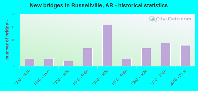
- New bridges - historical statistics
- 31930-1939
- 31940-1949
- 21950-1959
- 71960-1969
- 161970-1979
- 31980-1989
- 71990-1999
- 92000-2009
- 82010-2019

- Reconstructed bridges - Historical Statistics
- 21960-1969
- 11970-1979
- 01980-1989
- 21990-1999


- Bridge Condition - Deck
- 60.0%Good
- 32.5%Satisfactory
- 7.5%Fair

- Bridge Condition - Superstructure
- 2.5%Excellent
- 10.0%Very good
- 52.5%Good
- 20.0%Satisfactory
- 15.0%Fair

- Bridge Condition - Substructure
- 5.0%Very good
- 57.5%Good
- 32.5%Satisfactory
- 5.0%Fair

- Bridge Condition - Channel
- 16.3%Very good
- 57.1%Good
- 18.4%Satisfactory
- 8.2%Fair

- Bridge Condition - Culverts
- 5.6%Very good
- 94.4%Good
Find on map >> Show street view
Structure Number: 23477, Location: 0.1 Mi. E. of Weir Rd. (Lat: 35.285442, Lng: -93.104733), Route carried "on" structure: City street 50500, Year Built: 2011, Status: Open, Structure Length: 2.35m (7.71ft), Average Daily Traffic: 3,300 (year 2018), Truck Traffic: 1%, Average Future Daily Traffic: 165 (year 2031), Features Intersected: Creek, Facility Carried by Structure: Russell Rd - B
Minimum Vertical Clearance: 30+ m (98+ ft), Kilometerpoint: 1.384, Lanes on structure: 3, Owner: City or Municipal Highway Agency, Approaching Roadway Width: 10.7m (35.1ft), Skew: 4 degrees, Material/Design: Concrete, Design/Construction: Culvert, Number Of Spans In Main Unit: 5, Length of Maximum Span: 4.3m (14.1ft), Curb or Sidewalk Widths: Left: 0.0m, Right: 2.4m (7.9ft)
Condition: Channel: Good, Culverts: Good, Operating Rating: 35.4 metric tons, Method Used To Determine Operating Rating: Load Factor (LF), Inventory Rating: 21.8 metric tons, Method Used To Determine Inventory Rating: Load Factor (LF), Structural Evaluation: Somewhat better than minimum adequacy, Waterway Adequacy: Equal to present desirable criteria, Approach Roadway Alignment: Superior to present desirable criteria, Designated Inspection Frequency: Every 24 months, Critical Feature Inspection Frequency: Every 24 months, Inspection Date: May 2021
Find on map >> Show street view
Structure Number: 23613, Location: 0.55 Mi N of W Pkway Dr (Lat: 35.296917, Lng: -93.146556), Route carried "on" structure: City street 45140, Year Built: 2012, Status: Open, Structure Length: 2.74m (8.99ft), Average Daily Traffic: 7,000 (year 2018), Truck Traffic: 1%, Average Future Daily Traffic: 280 (year 2032), Design Load: HS 20, Features Intersected: Prairie Creek, Facility Carried by Structure: N. Phoenix Ave.
Minimum Vertical Clearance: 30+ m (98+ ft), Kilometerpoint: 1.690, Lanes on structure: 2, Owner: City or Municipal Highway Agency, Approaching Roadway Width: 11.9m (39.0ft), Material/Design: Steel continuous, Design/Construction: Stringer/Multi-beam, Number Of Spans In Main Unit: 3, Length of Maximum Span: 9.1m (29.9ft), Curb-To-Curb Width: 11.0m (36.1ft), Out-to-Out Width: 11.9m (39.0ft)
Condition: Deck: Good, Superstructure: Excellent, Substructure: Very good, Channel: Very good, Operating Rating: 54.4 metric tons, Method Used To Determine Operating Rating: Load Factor (LF), Inventory Rating: 32.7 metric tons, Method Used To Determine Inventory Rating: Load Factor (LF), Structural Evaluation: Equal to present desirable criteria, Deck Geometry: Meets minimum limits, Waterway Adequacy: Equal to present desirable criteria, Approach Roadway Alignment: Equal to present desirable criteria, Designated Inspection Frequency: Every 24 months, Critical Feature Inspection Frequency: Every 24 months, Inspection Date: August 2020, Deck Structure Type: Concrete Cast-file-Place, Wearing Surface/Protective System: Wearing Surface: Monolithic Concrete
Find on map >> Show street view
Structure Number: 23621, Location: 0.25 MI N JCT US 64 (Lat: 35.285697, Lng: -93.146739), Route carried "on" structure: City street 45140, Year Built: 2014, Status: Open, Structure Length: 4.34m (14.24ft), Average Daily Traffic: 7,500 (year 2018), Average Future Daily Traffic: 9,600 (year 2038), Design Load: HL 93, Features Intersected: Union Pacific Railroad, Facility Carried by Structure: N. Phoenix Ave.
Minimum Vertical Clearance: 30+ m (98+ ft), Kilometerpoint: 0.402, Lanes on structure: 2, Owner: City or Municipal Highway Agency, Approaching Roadway Width: 10.7m (35.1ft), Skew: 2 degrees, Material/Design: Steel, Design/Construction: Stringer/Multi-beam, Number Of Spans In Main Unit: 1, Length of Maximum Span: 42.7m (140.1ft), Curb or Sidewalk Widths: Left: 0.0m, Right: 2.0m (6.6ft), Curb-To-Curb Width: 10.7m (35.1ft), Out-to-Out Width: 13.4m (44.0ft)
Condition: Deck: Good, Superstructure: Very good, Substructure: Very good, Operating Rating: 54.4 metric tons, Method Used To Determine Operating Rating: Load and Resistance Factor (LRFR), Inventory Rating: 32.7 metric tons, Method Used To Determine Inventory Rating: Load and Resistance Factor (LRFR), Structural Evaluation: Equal to present desirable criteria, Deck Geometry: Meets minimum limits, Underclear: Superior to present desirable criteria, Approach Roadway Alignment: Better than present minimum criteria, Designated Inspection Frequency: Every 24 months, Critical Feature Inspection Frequency: Every 24 months, Inspection Date: May 2020, Deck Structure Type: Concrete Cast-file-Place, Wearing Surface/Protective System: Wearing Surface: Monolithic Concrete
Find on map >> Show street view
Structure Number: A2679, Location: 0.5 M NE of Yell Co (Lat: 35.228761, Lng: -93.143889), Route carried "on" structure: State highway 7, Year Built: 1950, Year Reconstructed: 1974, Status: Open, Structure Length: 5.55m (18.21ft), Average Daily Traffic: 23,000 (year 2018), Truck Traffic: 1%, Average Future Daily Traffic: 29,377 (year 2028), Design Load: HS 20, Features Intersected: Whig Creek-Pope
Minimum Vertical Clearance: 30+ m (98+ ft), Kilometerpoint: 0.402, Lanes on structure: 4, Base Highway Network: Yes (Inventory Route: 71, Subroute: 1), Owner: State Highway Agency, Approaching Roadway Width: 20.7m (67.9ft), Material/Design: Steel, Design/Construction: Stringer/Multi-beam, Number Of Spans In Main Unit: 5, Length of Maximum Span: 11.0m (36.1ft), Curb-To-Curb Width: 20.7m (67.9ft), Out-to-Out Width: 21.7m (71.2ft)
Condition: Deck: Good, Superstructure: Fair, Substructure: Fair, Channel: Fair, Operating Rating: 50.8 metric tons, Method Used To Determine Operating Rating: Load Factor (LF), Inventory Rating: 30.8 metric tons, Method Used To Determine Inventory Rating: Load Factor (LF), Structural Evaluation: Somewhat better than minimum adequacy, Deck Geometry: Superior to present desirable criteria, Waterway Adequacy: Equal to present desirable criteria, Approach Roadway Alignment: Equal to present minimum criteria, Designated Inspection Frequency: Every 24 months, Critical Feature Inspection Frequency: Every 24 months, Other Special Inspection Frequency: Every 24 months, Inspection Date: August 2021, Other Special Inspection Date: August 2020, Deck Structure Type: Concrete Cast-file-Place, Wearing Surface/Protective System: Wearing Surface: Monolithic Concrete
Find on map >> Show street view
Structure Number: A268, Location: 1.52 M NE of Yell Co. (Lat: 35.242778, Lng: -93.139200), Route carried "on" structure: State highway 7, Year Built: 1950, Year Reconstructed: 1974, Status: Open, Structure Length: 3.35m (10.99ft), Average Daily Traffic: 23,000 (year 2018), Truck Traffic: 1%, Average Future Daily Traffic: 29,377 (year 2028), Design Load: HS 20, Features Intersected: Whig Creek
Minimum Vertical Clearance: 30+ m (98+ ft), Kilometerpoint: 2.446, Lanes on structure: 4, Base Highway Network: Yes, Owner: State Highway Agency, Approaching Roadway Width: 20.7m (67.9ft), Material/Design: Steel, Design/Construction: Stringer/Multi-beam, Number Of Spans In Main Unit: 3, Length of Maximum Span: 11.0m (36.1ft), Curb-To-Curb Width: 20.7m (67.9ft), Out-to-Out Width: 21.7m (71.2ft)
Condition: Deck: Satisfactory, Superstructure: Good, Substructure: Satisfactory, Channel: Satisfactory, Operating Rating: 49.0 metric tons, Method Used To Determine Operating Rating: Load Factor (LF), Inventory Rating: 29.0 metric tons, Method Used To Determine Inventory Rating: Load Factor (LF), Structural Evaluation: Equal to present minimum criteria, Deck Geometry: Superior to present desirable criteria, Waterway Adequacy: Equal to present desirable criteria, Approach Roadway Alignment: Equal to present desirable criteria, Designated Inspection Frequency: Every 24 months, Critical Feature Inspection Frequency: Every 24 months, Inspection Date: August 2020, Deck Structure Type: Concrete Cast-file-Place, Wearing Surface/Protective System: Wearing Surface: Monolithic Concrete
Find on map >> Show street view
Structure Number: A3967, Location: LM 85.80 om I-40 (Lat: 35.268100, Lng: -93.069200), Route carried "on" structure: Interstate 40, Year Built: 1967, Status: Open, Structure Length: 3.20m (10.50ft), Average Daily Traffic: 8,000 (year 2018), Truck Traffic: 1%, Average Future Daily Traffic: 17,882 (year 2028), Design Load: HS 20+Mod, Features Intersected: OLD COVE RD (CR 273)
Minimum Vertical Clearance: 30+ m (98+ ft), Kilometerpoint: 138.082, Lanes on structure: 2, Lanes under structure: 2, Base Highway Network: Yes, Owner: State Highway Agency, Approaching Roadway Width: 12.2m (40.0ft), Material/Design: Steel, Design/Construction: Stringer/Multi-beam, Number Of Spans In Main Unit: 3, Length of Maximum Span: 10.7m (35.1ft), Curb-To-Curb Width: 11.9m (39.0ft), Out-to-Out Width: 12.9m (42.3ft)
Condition: Deck: Good, Superstructure: Fair, Substructure: Satisfactory, Operating Rating: 54.4 metric tons, Method Used To Determine Operating Rating: Load Factor (LF), Inventory Rating: 32.7 metric tons, Method Used To Determine Inventory Rating: Load Factor (LF), Structural Evaluation: Somewhat better than minimum adequacy, Deck Geometry: Equal to present minimum criteria, Underclear: Meets minimum limits, Approach Roadway Alignment: Equal to present desirable criteria, Designated Inspection Frequency: Every 24 months, Critical Feature Inspection Frequency: Every 24 months, Inspection Date: January 2022, Deck Structure Type: Concrete Cast-file-Place, Wearing Surface/Protective System: Wearing Surface: Monolithic Concrete
Find on map >> Show street view
Structure Number: A6917, Location: 6.33 Mi E SH 333 & I-40 (Lat: 35.309381, Lng: -93.150939), Route carried "on" structure: Interstate 40, Year Built: 2013, Status: Open, Structure Length: 17.78m (58.33ft), Average Daily Traffic: 14,000 (year 2018), Truck Traffic: 33%, Average Future Daily Traffic: 14,688 (year 2028), Design Load: HS 20+Mod, Features Intersected: Illinois Bayou
Minimum Vertical Clearance: 30.44m (99.87ft), Kilometerpoint: 129.230, Lanes on structure: 2, Owner: State Highway Agency, Approaching Roadway Width: 11.6m (38.1ft), Material/Design: Steel continuous, Design/Construction: Stringer/Multi-beam, Number Of Spans In Main Unit: 5, Length of Maximum Span: 38.7m (127.0ft), Curb-To-Curb Width: 12.2m (40.0ft), Out-to-Out Width: 13.1m (43.0ft)
Condition: Deck: Good, Superstructure: Good, Substructure: Good, Channel: Good, Operating Rating: 54.4 metric tons, Method Used To Determine Operating Rating: Load Factor (LF), Inventory Rating: 32.7 metric tons, Method Used To Determine Inventory Rating: Load Factor (LF), Structural Evaluation: Better than present minimum criteria, Deck Geometry: Better than present minimum criteria, Waterway Adequacy: Superior to present desirable criteria, Approach Roadway Alignment: Equal to present desirable criteria, Designated Inspection Frequency: Every 24 months, Critical Feature Inspection Frequency: Every 24 months, Underwater Inspection Frequency: Every 60 months, Inspection Date: June 2021, Underwater Inspection Date: November 2021, Deck Structure Type: Concrete Cast-file-Place, Wearing Surface/Protective System: Wearing Surface: Monolithic Concrete, Deck Protection: Epoxy Coated Reinforcing
Find on map >> Show street view
Structure Number: B3967, Location: 2.36 MI NW OF SH 363 (Lat: 35.267911, Lng: -93.069550), Route carried "on" structure: Interstate 40, Year Built: 1967, Status: Open, Structure Length: 3.20m (10.50ft), Average Daily Traffic: 8,000 (year 2018), Truck Traffic: 24%, Average Future Daily Traffic: 43,100 (year 2038), Design Load: HS 20+Mod, Features Intersected: OLD COVE RD (CR 273)
Minimum Vertical Clearance: 30+ m (98+ ft), Kilometerpoint: 138.082, Lanes on structure: 2, Lanes under structure: 2, Base Highway Network: Yes, Owner: State Highway Agency, Approaching Roadway Width: 12.2m (40.0ft), Material/Design: Steel, Design/Construction: Stringer/Multi-beam, Number Of Spans In Main Unit: 3, Length of Maximum Span: 10.7m (35.1ft), Curb-To-Curb Width: 11.9m (39.0ft), Out-to-Out Width: 12.9m (42.3ft)
Condition: Deck: Good, Superstructure: Fair, Substructure: Satisfactory, Operating Rating: 46.3 metric tons, Method Used To Determine Operating Rating: Load Factor (LF), Inventory Rating: 28.1 metric tons, Method Used To Determine Inventory Rating: Load Factor (LF), Structural Evaluation: Somewhat better than minimum adequacy, Deck Geometry: Equal to present minimum criteria, Underclear: Meets minimum limits, Approach Roadway Alignment: Equal to present desirable criteria, Designated Inspection Frequency: Every 24 months, Critical Feature Inspection Frequency: Every 24 months, Inspection Date: January 2022, Deck Structure Type: Concrete Cast-file-Place, Wearing Surface/Protective System: Wearing Surface: Monolithic Concrete
Find on map >> Show street view
Structure Number: B6917, Location: 0.75 Mi W of Jct SH 7 (Lat: 35.309189, Lng: -93.151189), Route carried "on" structure: Interstate 40, Year Built: 2013, Status: Open, Structure Length: 17.77m (58.30ft), Average Daily Traffic: 14,000 (year 2018), Truck Traffic: 33%, Average Future Daily Traffic: 14,688 (year 2028), Design Load: HS 20+Mod, Features Intersected: Illinois Bayou
Minimum Vertical Clearance: 30.44m (99.87ft), Kilometerpoint: 129.230, Lanes on structure: 2, Base Highway Network: Yes, Owner: State Highway Agency, Approaching Roadway Width: 11.6m (38.1ft), Material/Design: Steel continuous, Design/Construction: Stringer/Multi-beam, Number Of Spans In Main Unit: 5, Length of Maximum Span: 38.7m (127.0ft), Curb-To-Curb Width: 12.2m (40.0ft), Out-to-Out Width: 13.1m (43.0ft)
Condition: Deck: Good, Superstructure: Very good, Substructure: Good, Channel: Good, Operating Rating: 53.5 metric tons, Method Used To Determine Operating Rating: Load Factor (LF), Inventory Rating: 32.7 metric tons, Method Used To Determine Inventory Rating: Load Factor (LF), Structural Evaluation: Better than present minimum criteria, Deck Geometry: Better than present minimum criteria, Waterway Adequacy: Superior to present desirable criteria, Approach Roadway Alignment: Equal to present desirable criteria, Designated Inspection Frequency: Every 24 months, Critical Feature Inspection Frequency: Every 24 months, Underwater Inspection Frequency: Every 60 months, Inspection Date: June 2021, Underwater Inspection Date: November 2021, Deck Structure Type: Concrete Cast-file-Place, Wearing Surface/Protective System: Wearing Surface: Monolithic Concrete, Deck Protection: Epoxy Coated Reinforcing
Find on map >> Show street view
Structure Number: X0186, Location: 0.75 M S of Jct I-40 (Lat: 35.298739, Lng: -93.134039), Route carried "on" structure: State highway 7, Year Built: 1972, Status: Open, Structure Length: 1.40m (4.59ft), Average Daily Traffic: 15,000 (year 2018), Truck Traffic: 3%, Average Future Daily Traffic: 22,991 (year 2028), Design Load: H 20, Features Intersected: Engineers Creek
Minimum Vertical Clearance: 30+ m (98+ ft), Kilometerpoint: 2.494, Lanes on structure: 4, Base Highway Network: Yes, Owner: State Highway Agency, Approaching Roadway Width: 15.2m (49.9ft), Skew: 4 degrees, Material/Design: Concrete, Design/Construction: Culvert, Number Of Spans In Main Unit: 3, Length of Maximum Span: 4.6m (15.1ft)
Condition: Channel: Good, Culverts: Good, Operating Rating: 42.6 metric tons, Method Used To Determine Operating Rating: Load Factor (LF), Inventory Rating: 25.4 metric tons, Method Used To Determine Inventory Rating: Load Factor (LF), Structural Evaluation: Equal to present minimum criteria, Waterway Adequacy: Equal to present desirable criteria, Approach Roadway Alignment: Equal to present desirable criteria, Designated Inspection Frequency: Every 24 months, Critical Feature Inspection Frequency: Every 24 months, Inspection Date: August 2020
Find on map >> Show street view
Structure Number: X0362, Location: 0.42 M E Jct SH 7 & 64 (Lat: 35.278619, Lng: -93.126458), Route carried "on" structure: US 64, Year Built: 1976, Status: Open, Structure Length: 1.37m (4.49ft), Average Daily Traffic: 15,618 (year 2018), Truck Traffic: 1%, Average Future Daily Traffic: 19,159 (year 2028), Design Load: H 20, Features Intersected: Prairie Creek
Minimum Vertical Clearance: 30+ m (98+ ft), Kilometerpoint: 18.198, Lanes on structure: 4, Base Highway Network: Yes, Owner: State Highway Agency, Approaching Roadway Width: 15.2m (49.9ft), Skew: 1 degrees, Material/Design: Concrete, Design/Construction: Culvert, Number Of Spans In Main Unit: 4, Length of Maximum Span: 3.0m (9.8ft)
Condition: Channel: Good, Culverts: Good, Operating Rating: 42.6 metric tons, Method Used To Determine Operating Rating: Load Factor (LF), Inventory Rating: 25.4 metric tons, Method Used To Determine Inventory Rating: Load Factor (LF), Structural Evaluation: Equal to present minimum criteria, Waterway Adequacy: Equal to present desirable criteria, Approach Roadway Alignment: Equal to present desirable criteria, Designated Inspection Frequency: Every 48 months, Critical Feature Inspection Frequency: Every 24 months, Inspection Date: August 2018
Find on map >> Show street view
Structure Number: X0693, Location: 0.4 M S of Jct US 64 (Lat: 35.271519, Lng: -93.091089), Route carried "on" structure: State highway 324, Year Built: 1987, Status: Open, Structure Length: 0.73m (2.40ft), Average Daily Traffic: 2,800 (year 2018), Truck Traffic: 20%, Average Future Daily Traffic: 3,065 (year 2028), Design Load: H 20, Features Intersected: Creek
Minimum Vertical Clearance: 30+ m (98+ ft), Kilometerpoint: 0.644, Lanes on structure: 2, Owner: State Highway Agency, Approaching Roadway Width: 8.5m (27.9ft), Skew: 3 degrees, Material/Design: Concrete, Design/Construction: Culvert, Number Of Spans In Main Unit: 2, Length of Maximum Span: 3.7m (12.1ft)
Condition: Channel: Good, Culverts: Good, Operating Rating: 39.9 metric tons, Method Used To Determine Operating Rating: Load Factor (LF), Inventory Rating: 23.6 metric tons, Method Used To Determine Inventory Rating: Load Factor (LF), Structural Evaluation: Equal to present minimum criteria, Waterway Adequacy: Equal to present desirable criteria, Approach Roadway Alignment: Equal to present minimum criteria, Designated Inspection Frequency: Every 48 months, Critical Feature Inspection Frequency: Every 24 months, Inspection Date: August 2020
Find on map >> Show street view
Structure Number: X0966, Location: 2.77 M NE of jct. SH 7 (Lat: 35.313231, Lng: -93.101569), Route carried "on" structure: State highway 124, Year Built: 1997, Status: Open, Structure Length: 1.42m (4.66ft), Average Daily Traffic: 4,800 (year 2018), Truck Traffic: 3%, Average Future Daily Traffic: 6,500 (year 2034), Design Load: H 20, Features Intersected: Shiloh Creek
Minimum Vertical Clearance: 30+ m (98+ ft), Kilometerpoint: 4.456, Lanes on structure: 2, Owner: State Highway Agency, Approaching Roadway Width: 22.9m (75.1ft), Material/Design: Concrete, Design/Construction: Culvert, Number Of Spans In Main Unit: 6, Length of Maximum Span: 2.1m (6.9ft)
Condition: Channel: Good, Culverts: Good, Operating Rating: 40.8 metric tons, Method Used To Determine Operating Rating: Load Factor (LF), Inventory Rating: 24.5 metric tons, Method Used To Determine Inventory Rating: Load Factor (LF), Structural Evaluation: Equal to present minimum criteria, Waterway Adequacy: Equal to present desirable criteria, Approach Roadway Alignment: Equal to present desirable criteria, Designated Inspection Frequency: Every 24 months, Critical Feature Inspection Frequency: Every 24 months, Inspection Date: November 2021
Find on map >> Show street view
Structure Number: X0967, Location: 5.77 MI NE OF JCT SH 7 (Lat: 35.332719, Lng: -93.061450), Route carried "on" structure: State highway 124, Year Built: 1997, Status: Open, Structure Length: 1.07m (3.51ft), Average Daily Traffic: 4,800 (year 2018), Truck Traffic: 22%, Average Future Daily Traffic: 6,259 (year 2028), Design Load: H 20, Features Intersected: Gum Log Creek
Minimum Vertical Clearance: 30+ m (98+ ft), Kilometerpoint: 9.284, Lanes on structure: 2, Owner: State Highway Agency, Approaching Roadway Width: 12.8m (42.0ft), Material/Design: Concrete, Design/Construction: Culvert, Number Of Spans In Main Unit: 4, Length of Maximum Span: 2.4m (7.9ft)
Condition: Channel: Good, Culverts: Good, Operating Rating: 49.9 metric tons, Method Used To Determine Operating Rating: Load Factor (LF), Inventory Rating: 29.9 metric tons, Method Used To Determine Inventory Rating: Load Factor (LF), Structural Evaluation: Better than present minimum criteria, Waterway Adequacy: Equal to present desirable criteria, Approach Roadway Alignment: Equal to present desirable criteria, Designated Inspection Frequency: Every 24 months, Critical Feature Inspection Frequency: Every 24 months, Inspection Date: November 2021
Find on map >> Show street view
Structure Number: X1265, Location: 0.1 Mi. SW. Jct. SH 7 (Lat: 35.298289, Lng: -93.137631), Route carried "on" structure: State highway 872, Year Built: 1940, Status: Open, Structure Length: 0.82m (2.69ft), Average Daily Traffic: 436 (year 2005), Truck Traffic: 1%, Average Future Daily Traffic: 639 (year 2025), Features Intersected: Engineers Creek
Minimum Vertical Clearance: 30+ m (98+ ft), Kilometerpoint: 2.559, Lanes on structure: 2, Owner: State Highway Agency, Approaching Roadway Width: 6.1m (20.0ft), Material/Design: Concrete, Design/Construction: Slab, Number Of Spans In Main Unit: 2, Length of Maximum Span: 4.0m (13.1ft), Curb-To-Curb Width: 7.5m (24.6ft), Out-to-Out Width: 8.1m (26.6ft)
Condition: Deck: Satisfactory, Superstructure: Satisfactory, Substructure: Satisfactory, Channel: Fair, Operating Rating: 29.9 metric tons, Method Used To Determine Operating Rating: Load Factor (LF), Inventory Rating: 18.1 metric tons, Method Used To Determine Inventory Rating: Load Factor (LF), Structural Evaluation: Somewhat better than minimum adequacy, Deck Geometry: Meets minimum limits, Waterway Adequacy: Equal to present minimum criteria, Approach Roadway Alignment: Equal to present desirable criteria, Designated Inspection Frequency: Every 24 months, Critical Feature Inspection Frequency: Every 24 months, Inspection Date: December 2021, Deck Structure Type: Concrete Cast-file-Place, Wearing Surface/Protective System: Wearing Surface: Bituminous
Find on map >> Show street view
Structure Number: X1266, Location: 0.30 Mi. SW. Jct. SH 7 (Lat: 35.298589, Lng: -93.140431), Route carried "on" structure: State highway 872, Year Built: 1940, Status: Open, Structure Length: 0.70m (2.30ft), Average Daily Traffic: 436 (year 2005), Truck Traffic: 1%, Average Future Daily Traffic: 639 (year 2025), Design Load: H 20, Features Intersected: Engineers Creek
Minimum Vertical Clearance: 30+ m (98+ ft), Kilometerpoint: 1.271, Lanes on structure: 2, Owner: State Highway Agency, Approaching Roadway Width: 7.0m (23.0ft), Skew: 1 degrees, Material/Design: Concrete, Design/Construction: Culvert, Number Of Spans In Main Unit: 2, Length of Maximum Span: 3.0m (9.8ft), Curb-To-Curb Width: 9.9m (32.5ft), Out-to-Out Width: 10.4m (34.1ft)
Condition: Channel: Satisfactory, Culverts: Good, Operating Rating: 41.7 metric tons, Method Used To Determine Operating Rating: Load Factor (LF), Inventory Rating: 25.4 metric tons, Method Used To Determine Inventory Rating: Load Factor (LF), Structural Evaluation: Equal to present minimum criteria, Deck Geometry: Equal to present minimum criteria, Waterway Adequacy: Better than present minimum criteria, Approach Roadway Alignment: Equal to present desirable criteria, Designated Inspection Frequency: Every 24 months, Critical Feature Inspection Frequency: Every 24 months, Inspection Date: December 2021
Find on map >> Show street view
Structure Number: X1339, Location: 0.47 M N jct US 64 (Lat: 35.284989, Lng: -93.106811), Route carried "on" structure: State highway 124, Year Built: 2008, Status: Open, Structure Length: 0.91m (2.99ft), Average Daily Traffic: 19,215 (year 2016), Truck Traffic: 3%, Average Future Daily Traffic: 19,797 (year 2027), Design Load: H 20, Features Intersected: Creek
Minimum Vertical Clearance: 30+ m (98+ ft), Kilometerpoint: 0.756, Lanes on structure: 5, Owner: State Highway Agency, Approaching Roadway Width: 17.7m (58.1ft), Skew: 1 degrees, Material/Design: Concrete, Design/Construction: Culvert, Number Of Spans In Main Unit: 3, Length of Maximum Span: 2.7m (8.9ft), Curb or Sidewalk Widths: Left: 2.4m (7.9ft), Right: 2.4m (7.9ft)
Condition: Channel: Fair, Culverts: Good, Operating Rating: 32.7 metric tons, Method Used To Determine Operating Rating: Load Factor (LF), Inventory Rating: 19.1 metric tons, Method Used To Determine Inventory Rating: Load Factor (LF), Structural Evaluation: Meets minimum limits, Waterway Adequacy: Equal to present desirable criteria, Approach Roadway Alignment: Equal to present desirable criteria, Designated Inspection Frequency: Every 24 months, Critical Feature Inspection Frequency: Every 24 months, Inspection Date: October 2020
Find on map >> Show street view
Structure Number: 3589, Location: At Jct I-40 & O St. (Lat: 35.296000, Lng: -93.120431), Route carried "under" structure: Interstate 40, Structure Length: 0. m, Average Daily Traffic: 14,500 (year 2012), Truck Traffic: 1%, Features Intersected: I 40-SEC 22, Facility Carried by Structure: E. 'O' Street
Minimum Vertical Clearance: 5.08m (16.67ft), Kilometerpoint: 132.433, Length of Maximum Span: 0.0m
Find on map >> Show street view
Structure Number: 3589, Location: At Jct I-40 & O St. (Lat: 35.296000, Lng: -93.120431), Route carried "under" structure: Interstate 40, Structure Length: 0. m, Average Daily Traffic: 14,500 (year 2012), Truck Traffic: 1%, Features Intersected: I 40-SEC 22, Facility Carried by Structure: E. 'O' Street
Minimum Vertical Clearance: 5.71m (18.73ft), Kilometerpoint: 132.433, Length of Maximum Span: 0.0m
Find on map >> Show street view
Structure Number: 5645, Location: 0.11 M E Jct SH 7 & 64 (Lat: 35.278203, Lng: -93.131703), Route carried "under" structure: City street 6160, Structure Length: 0. m, Average Daily Traffic: 279 (year 1983), Truck Traffic: 1%, Features Intersected: 2 City Sts, RR, Facility Carried by Structure: US 64-SEC 6
Minimum Vertical Clearance: 3.47m (11.38ft), Kilometerpoint: 0.080, Length of Maximum Span: 0.0m
Find on map >> Show street view
Structure Number: 5645, Location: 0.11 M E Jct SH 7 & 64 (Lat: 35.278203, Lng: -93.131703), Route carried "under" structure: City street 15700, Structure Length: 0. m, Average Daily Traffic: 2,565 (year 1983), Truck Traffic: 1%, Features Intersected: 2 City Sts, RR, Facility Carried by Structure: US 64-SEC 6
Minimum Vertical Clearance: 4.93m (16.17ft), Kilometerpoint: 0.064, Length of Maximum Span: 0.0m
Find on map >> Show street view
Structure Number: 5645, Location: 0.11 M E Jct SH 7 & 64 (Lat: 35.278203, Lng: -93.131703), Route carried "under" structure: City street , Structure Length: 0. m, Truck Traffic: 1%, Features Intersected: 2 City sts, RR, Facility Carried by Structure: US 64-SEC 6
Minimum Vertical Clearance: 4.96m (16.27ft), Kilometerpoint: 0.966, Length of Maximum Span: 0.0m
Find on map >> Show street view
Structure Number: 6666, Location: I-40 & SH 331 (Lat: 35.282331, Lng: -93.092889), Route carried "under" structure: Interstate 40, Structure Length: 0. m, Average Daily Traffic: 14,500 (year 2013), Truck Traffic: 18%, Features Intersected: I-40 SEC 22, Facility Carried by Structure: SH 331 SEC 1
Minimum Vertical Clearance: 5.15m (16.90ft), Kilometerpoint: 135.394, Length of Maximum Span: 0.0m
Find on map >> Show street view
Structure Number: 6666, Location: I-40 & SH 331 (Lat: 35.282331, Lng: -93.092889), Route carried "under" structure: Interstate 40, Structure Length: 0. m, Average Daily Traffic: 14,500 (year 2013), Truck Traffic: 18%, Features Intersected: I-40 SEC 22, Facility Carried by Structure: SH 331 SEC 1
Minimum Vertical Clearance: 4.99m (16.37ft), Kilometerpoint: 135.394, Length of Maximum Span: 0.0m
Find on map >> Show street view
Structure Number: 6803, Location: @ INTER I 40 & SH 7 (Lat: 35.305731, Lng: -93.138361), Route carried "under" structure: Interstate 40, Structure Length: 0. m, Average Daily Traffic: 14,500 (year 2013), Truck Traffic: 1%, Features Intersected: I 40 -SEC. 22, Facility Carried by Structure: SH 7 -SEC. 15
Minimum Vertical Clearance: 5.12m (16.80ft), Kilometerpoint: 130.437, Length of Maximum Span: 0.0m
Find on map >> Show street view
Structure Number: 6803, Location: @ INTER I 40 & SH 7 (Lat: 35.305731, Lng: -93.138361), Route carried "under" structure: Interstate 40, Structure Length: 0. m, Average Daily Traffic: 14,500 (year 2013), Truck Traffic: 1%, Features Intersected: I 40 -SEC. 22, Facility Carried by Structure: SH 7 -SEC. 15
Minimum Vertical Clearance: 5.05m (16.57ft), Kilometerpoint: 130.437, Length of Maximum Span: 0.0m
Find on map >> Show street view
Structure Number: 7007, Location: 0.2 Mi N. of Jct. US 64 (Lat: 35.321461, Lng: -93.191061), Route carried "under" structure: Interstate 40, Structure Length: 0. m, Average Daily Traffic: 13,000 (year 2013), Truck Traffic: 5%, Features Intersected: I 40 -SEC. 22, Facility Carried by Structure: Dwight Mission Rd.
Minimum Vertical Clearance: 5.99m (19.65ft), Kilometerpoint: 125.126, Length of Maximum Span: 0.0m
Find on map >> Show street view
Structure Number: 7007, Location: 0.2 Mi N. of Jct. US 64 (Lat: 35.321461, Lng: -93.191061), Route carried "under" structure: Interstate 40, Structure Length: 0. m, Average Daily Traffic: 13,000 (year 2013), Truck Traffic: 5%, Features Intersected: I 40 -SEC. 22, Facility Carried by Structure: Dwight Mission Rd.
Minimum Vertical Clearance: 4.95m (16.24ft), Kilometerpoint: 125.126, Length of Maximum Span: 0.0m
Find on map >> Show street view
Structure Number: 7014, Location: 0.85 MI N JCT US 64 (Lat: 35.290450, Lng: -93.106731), Route carried "under" structure: Interstate 40, Structure Length: 0. m, Average Daily Traffic: 14,500 (year 2012), Truck Traffic: 1%, Features Intersected: I 40 - SEC. 22, Facility Carried by Structure: SH 124
Minimum Vertical Clearance: 5.43m (17.81ft), Kilometerpoint: 133.817, Length of Maximum Span: 0.0m
Find on map >> Show street view
Structure Number: 7014, Location: 0.85 MI N JCT US 64 (Lat: 35.290450, Lng: -93.106731), Route carried "under" structure: Interstate 40, Structure Length: 0. m, Average Daily Traffic: 14,500 (year 2012), Truck Traffic: 1%, Features Intersected: I 40 - SEC. 22, Facility Carried by Structure: SH 124
Minimum Vertical Clearance: 5.38m (17.65ft), Kilometerpoint: 133.817, Length of Maximum Span: 0.0m
Find on map >> Show street view
Structure Number: A3967, Location: LM 85.80 om I-40 (Lat: 35.268100, Lng: -93.069200), Route carried "under" structure: County highway 273, Structure Length: 0. m, Average Daily Traffic: 89 (year 1983), Truck Traffic: 1%, Features Intersected: OLD COVE RD (CR 273), Facility Carried by Structure: I 40-SEC 22, WB LN
Minimum Vertical Clearance: 4.34m (14.24ft), Kilometerpoint: 0.097, Length of Maximum Span: 0.0m
Find on map >> Show street view
Structure Number: B3967, Location: 2.36 MI NW OF SH 363 (Lat: 35.267911, Lng: -93.069550), Route carried "under" structure: County highway 273, Structure Length: 0. m, Average Daily Traffic: 89 (year 1983), Truck Traffic: 1%, Features Intersected: OLD COVE RD (CR 273), Facility Carried by Structure: I 40-SEC 22, EB LN
Minimum Vertical Clearance: 4.49m (14.73ft), Kilometerpoint: 0.080, Length of Maximum Span: 0.0m