Bridge Statistics for Seaside, California (CA)
Condition, Traffic, Stress, Structural Evaluation, Project Costs
- National Bridge Inventory (NBI) Statistics
- 10Number of bridges
- 220ft / 66.8mTotal length
- 230,525Total average daily traffic
- 8,785Total average daily truck traffic
- National Bridge Inventory (NBI) Registered Bridges for Seaside
- No street view available for this location
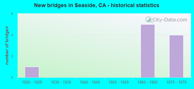
- New bridges - historical statistics
- 11920-1929
- 51960-1969
- 41970-1979


- Bridge Condition - Deck
- 75.0%Good
- 25.0%Fair

- Bridge Condition - Superstructure
- 75.0%Good
- 25.0%Satisfactory

- Bridge Condition - Substructure
- 75.0%Good
- 25.0%Fair

- Bridge Condition - Channel
- 33.3%Excellent
- 33.3%Very good
- 33.3%Fair

- Bridge Condition - Culverts
- 50.0%Good
- 50.0%Satisfactory
Find on map >> Show street view
Structure Number: 44 0162R, Location: 05-MON-001-R79.33-SEA (Lat: 36.609869, Lng: -121.858131), Route carried "on" structure: State highway 1, Year Built: 1968, Status: Open, Structure Length: 5.30m (17.39ft), Average Daily Traffic: 29,500 (year 2009), Truck Traffic: 4%, Average Future Daily Traffic: 47,567 (year 2043), Design Load: HS 20, Features Intersected: STATE ROUTE 218
Minimum Vertical Clearance: 30+ m (98+ ft), Kilometerpoint: 79.330, Lanes on structure: 2, Lanes under structure: 2, Base Highway Network: Yes (, Subroute: 1), Owner: State Highway Agency, Approaching Roadway Width: 11.3m (37.1ft), Skew: 3 degrees, Material/Design: Concrete continuous, Design/Construction: Box Beam or Girders - Multiple, Number Of Spans In Main Unit: 3, Length of Maximum Span: 25.0m (82.0ft), Curb-To-Curb Width: 11.3m (37.1ft), Out-to-Out Width: 11.9m (39.0ft)
Condition: Deck: Good, Superstructure: Good, Substructure: Good, Operating Rating: 48.9 metric tons, Method Used To Determine Operating Rating: Load and Resistance Factor Rating (LRFR) rating reported by rating factor(RF) method using HL-93 loadings, Inventory Rating: 37.9 metric tons, Method Used To Determine Inventory Rating: Load and Resistance Factor Rating (LRFR) rating reported by rating factor(RF) method using HL-93 loadings, Structural Evaluation: Better than present minimum criteria, Deck Geometry: Somewhat better than minimum adequacy, Underclear: Equal to present minimum criteria, Approach Roadway Alignment: Equal to present minimum criteria, Designated Inspection Frequency: Every 48 months, Inspection Date: July 2021, Deck Structure Type: Concrete Cast-file-Place
Find on map >> Show street view
Structure Number: 44 0199, Location: 05-MON-001-R82.89 (Lat: 36.647350, Lng: -121.815969), Route carried "on" structure: Ramp State highway 1, Year Built: 1973, Status: Open, Structure Length: 7.99m (26.21ft), Average Daily Traffic: 7,000 (year 2013), Truck Traffic: 3%, Average Future Daily Traffic: 11,719 (year 2043), Design Load: HS 20+Mod, Features Intersected: STATE ROUTE 1
Minimum Vertical Clearance: 30+ m (98+ ft), Kilometerpoint: 82.890, Lanes on structure: 3, Lanes under structure: 6, Base Highway Network: Yes, Owner: State Highway Agency, Approaching Roadway Width: 15.5m (50.9ft), Skew: 3 degrees, Material/Design: Prestressed concrete continuous, Design/Construction: Box Beam or Girders - Multiple, Number Of Spans In Main Unit: 2, Length of Maximum Span: 45.7m (149.9ft), Curb-To-Curb Width: 17.7m (58.1ft), Out-to-Out Width: 18.3m (60.0ft)
Condition: Deck: Good, Superstructure: Good, Substructure: Good, Operating Rating: 49.2 metric tons, Method Used To Determine Operating Rating: Load and Resistance Factor Rating (LRFR) rating reported by rating factor(RF) method using HL-93 loadings, Inventory Rating: 30.1 metric tons, Method Used To Determine Inventory Rating: Load and Resistance Factor Rating (LRFR) rating reported by rating factor(RF) method using HL-93 loadings, Structural Evaluation: Better than present minimum criteria, Deck Geometry: Superior to present desirable criteria, Underclear: Meets minimum limits, Approach Roadway Alignment: Equal to present minimum criteria, Designated Inspection Frequency: Every 24 months, Inspection Date: August 2021, Deck Structure Type: Concrete Cast-file-Place
Find on map >> Show street view
Structure Number: 44 02, Location: 05-MON-001-R83.27 (Lat: 36.652553, Lng: -121.815314), Route carried "on" structure: State highway 1, Year Built: 1973, Status: Open, Structure Length: 1.16m (3.81ft), Average Daily Traffic: 59,000 (year 2009), Truck Traffic: 4%, Average Future Daily Traffic: 90,199 (year 2037), Design Load: HS 20+Mod, Features Intersected: 1ST STREET
Minimum Vertical Clearance: 30+ m (98+ ft), Kilometerpoint: 83.270, Lanes on structure: 6, Lanes under structure: 2, Base Highway Network: Yes (, Subroute: 1), Owner: State Highway Agency, Approaching Roadway Width: 31.1m (102.0ft), Skew: 31 degrees, Material/Design: Concrete, Design/Construction: Box Beam or Girders - Multiple, Number Of Spans In Main Unit: 1, Length of Maximum Span: 11.3m (37.1ft), Curb-To-Curb Width: 75.7m (248.4ft), Out-to-Out Width: 75.7m (248.4ft)
Condition: Deck: Good, Superstructure: Good, Substructure: Good, Operating Rating: 99.8 metric tons, Method Used To Determine Operating Rating: Load Factor (LF), Inventory Rating: 99.8 metric tons, Method Used To Determine Inventory Rating: Load Factor (LF), Structural Evaluation: Better than present minimum criteria, Deck Geometry: Superior to present desirable criteria, Underclear: Meets minimum limits, Approach Roadway Alignment: Equal to present desirable criteria, Designated Inspection Frequency: Every 48 months, Inspection Date: August 2019, Deck Structure Type: Concrete Cast-file-Place
Find on map >> Show street view
Structure Number: 44 0227, Location: 05-MON-001-R79.34-SEA (Lat: 36.609497, Lng: -121.858006), Route carried "on" structure: Ramp State highway 1, Year Built: 1967, Year Reconstructed: 1998, Status: Open, Structure Length: 0.85m (2.79ft), Average Daily Traffic: 12,800 (year 2013), Truck Traffic: 4%, Average Future Daily Traffic: 19,735 (year 2043), Design Load: HS 20+Mod, Features Intersected: ROBERTS LAKE OUTLET
Minimum Vertical Clearance: 30+ m (98+ ft), Kilometerpoint: 79.340, Lanes on structure: 4, Owner: State Highway Agency, Approaching Roadway Width: 6.7m (22.0ft), Skew: 3 degrees, Material/Design: Concrete continuous, Design/Construction: Culvert, Number Of Spans In Main Unit: 4, Length of Maximum Span: 1.8m (5.9ft)
Condition: Channel: Fair, Culverts: Good, Operating Rating: 54.1 metric tons, Method Used To Determine Operating Rating: Field evaluation and documented engineering judgment, Inventory Rating: 32.4 metric tons, Method Used To Determine Inventory Rating: Field evaluation and documented engineering judgment, Structural Evaluation: Better than present minimum criteria, Waterway Adequacy: Equal to present minimum criteria, Approach Roadway Alignment: Better than present minimum criteria, Designated Inspection Frequency: Every 24 months, Inspection Date: August 2021
Find on map >> Show street view
Structure Number: 44C0101, Location: E OF US 101 NR SAN ARDO (Lat: 36.015942, Lng: -120.914450), Route carried "on" structure: County highway , Year Built: 1929, Status: Open, Structure Length: 50.41m (165.39ft), Average Daily Traffic: 1,500 (year 2017), Truck Traffic: 1%, Average Future Daily Traffic: 3,163 (year 2039), Design Load: H 15, Features Intersected: SALINAS RIVER, Facility Carried by Structure: CATTLEMEN ROAD
Minimum Vertical Clearance: 30+ m (98+ ft), Kilometerpoint: 0.000, Lanes on structure: 2, Owner: County Highway Agency, Approaching Roadway Width: 6.7m (22.0ft), Material/Design: Steel, Design/Construction: Truss - Deck, Number Of Spans In Main Unit: 10, Number Of Approach Spans: 17, Length of Maximum Span: 30.5m (100.1ft), Curb-To-Curb Width: 7.3m (24.0ft), Out-to-Out Width: 8.3m (27.2ft)
Condition: Deck: Fair, Superstructure: Satisfactory, Substructure: Fair, Channel: Excellent, Operating Rating: 37.6 metric tons, Method Used To Determine Operating Rating: Load Factor (LF), Inventory Rating: 22.4 metric tons, Method Used To Determine Inventory Rating: Load Factor (LF), Structural Evaluation: Somewhat better than minimum adequacy, Deck Geometry: Meets minimum limits, Waterway Adequacy: Better than present minimum criteria, Approach Roadway Alignment: Better than present minimum criteria, Designated Inspection Frequency: Every 24 months, Critical Feature Inspection Frequency: Every 24 months, Inspection Date: August 2021, Critical Feature Inspection Date: September 2020, Deck Structure Type: Concrete Cast-file-Place, Wearing Surface/Protective System: Wearing Surface: Bituminous
Find on map >> Show street view
Structure Number: 44C0103, Location: BTWN SH 1 & SH 218 (Lat: 36.606197, Lng: -121.858119), Route carried "on" structure: City street , Year Built: 1977, Status: Open, Structure Length: 1.04m (3.41ft), Average Daily Traffic: 39,830 (year 1986), Truck Traffic: 3%, Average Future Daily Traffic: 46,716 (year 2037), Features Intersected: CANYON DEL REY CREEK, Facility Carried by Structure: DEL MONTE BLVD
Minimum Vertical Clearance: 30+ m (98+ ft), Kilometerpoint: 0.000, Lanes on structure: 5, Base Highway Network: Yes, Owner: City or Municipal Highway Agency, Approaching Roadway Width: 22.6m (74.1ft), Skew: 30 degrees, Material/Design: Concrete continuous, Design/Construction: Culvert, Number Of Spans In Main Unit: 2, Length of Maximum Span: 4.9m (16.1ft), Curb or Sidewalk Widths: Left: 0.0m, Right: 2.3m (7.5ft), Curb-To-Curb Width: 22.6m (74.1ft), Out-to-Out Width: 27.4m (89.9ft)
Condition: Channel: Very good, Culverts: Satisfactory, Operating Rating: 54.1 metric tons, Method Used To Determine Operating Rating: Field evaluation and documented engineering judgment, Inventory Rating: 32.4 metric tons, Method Used To Determine Inventory Rating: Field evaluation and documented engineering judgment, Structural Evaluation: Equal to present minimum criteria, Deck Geometry: Equal to present minimum criteria, Waterway Adequacy: Equal to present minimum criteria, Approach Roadway Alignment: Equal to present desirable criteria, Designated Inspection Frequency: Every 48 months, Inspection Date: June 2020
Find on map >> Show street view
Structure Number: 44 0162L, Location: 05-MON-001-R79.33-SEA (Lat: 36.610128, Lng: -121.858122), Route carried "under" structure: State highway 218, Year Built: 1968, Structure Length: 0. m, Average Daily Traffic: 9,200 (year 2005), Truck Traffic: 5%, Features Intersected: STATE ROUTE 218, Facility Carried by Structure: STATE ROUTE 1 SB
Minimum Vertical Clearance: 5.96m (19.55ft), Kilometerpoint: 0.010, Lanes on structure: 2, Lanes under structure: 2, Material/Design: Concrete continuous, Design/Construction: Box Beam or Girders - Multiple, Length of Maximum Span: 25.0m (82.0ft)
Find on map >> Show street view
Structure Number: 44 0162R, Location: 05-MON-001-R79.33-SEA (Lat: 36.609869, Lng: -121.858131), Route carried "under" structure: State highway 218, Year Built: 1968, Structure Length: 0. m, Average Daily Traffic: 9,200 (year 2005), Truck Traffic: 5%, Features Intersected: STATE ROUTE 218, Facility Carried by Structure: STATE ROUTE 1 NB
Minimum Vertical Clearance: 5.86m (19.23ft), Kilometerpoint: 0.010, Lanes on structure: 2, Lanes under structure: 2, Material/Design: Concrete continuous, Design/Construction: Box Beam or Girders - Multiple, Length of Maximum Span: 25.0m (82.0ft)
Find on map >> Show street view
Structure Number: 44 0199, Location: 05-MON-001-R82.89 (Lat: 36.647350, Lng: -121.815969), Route carried "under" structure: State highway 1, Year Built: 1973, Structure Length: 0. m, Average Daily Traffic: 59,000 (year 2009), Truck Traffic: 4%, Features Intersected: STATE ROUTE 1
Minimum Vertical Clearance: 5.44m (17.85ft), Kilometerpoint: 82.890, Lanes on structure: 3, Lanes under structure: 6, Material/Design: Prestressed concrete continuous, Design/Construction: Box Beam or Girders - Multiple, Length of Maximum Span: 45.7m (149.9ft)
Find on map >> Show street view
Structure Number: 44C0104, Location: 0.2 MI E YOSEMITE ST (Lat: 36.614333, Lng: -121.826644), Route carried "under" structure: City street , Year Built: 1960, Structure Length: 0. m, Average Daily Traffic: 3,495 (year 1990), Truck Traffic: 1%, Features Intersected: SAN PABLO AVE, Facility Carried by Structure: PEDESTRIAN WALKWAY
Minimum Vertical Clearance: 4.88m (16.01ft), Kilometerpoint: 0.000, Lanes under structure: 2, Material/Design: Wood or Timber, Design/Construction: Stringer/Multi-beam, Length of Maximum Span: 27.0m (88.6ft)