Bridge Statistics for Shawnee, Kansas (KS)
Condition, Traffic, Stress, Structural Evaluation, Project Costs
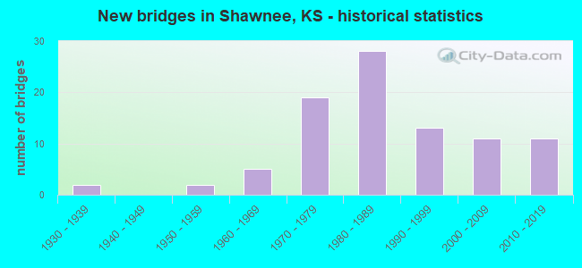
- New bridges - historical statistics
- 21930-1939
- 21950-1959
- 51960-1969
- 191970-1979
- 281980-1989
- 131990-1999
- 112000-2009
- 112010-2019
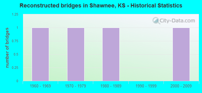
- Reconstructed bridges - Historical Statistics
- 11960-1969
- 11970-1979
- 11980-1989
- 01990-1999
- 12000-2009
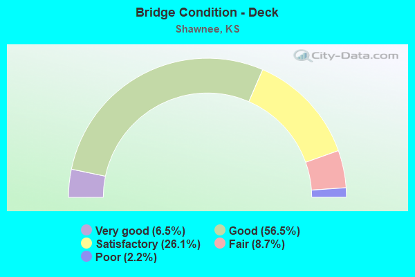
- Bridge Condition - Deck
- 6.5%Very good
- 56.5%Good
- 26.1%Satisfactory
- 8.7%Fair
- 2.2%Poor
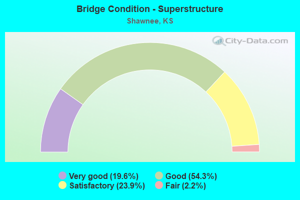
- Bridge Condition - Superstructure
- 19.6%Very good
- 54.3%Good
- 23.9%Satisfactory
- 2.2%Fair
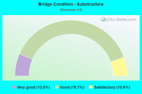
- Bridge Condition - Substructure
- 13.0%Very good
- 76.1%Good
- 10.9%Satisfactory
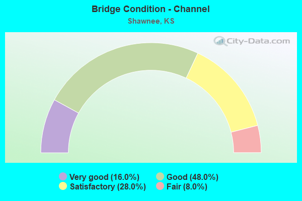
- Bridge Condition - Channel
- 16.0%Very good
- 48.0%Good
- 28.0%Satisfactory
- 8.0%Fair
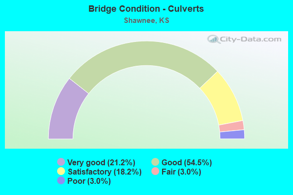
- Bridge Condition - Culverts
- 21.2%Very good
- 54.5%Good
- 18.2%Satisfactory
- 3.0%Fair
- 3.0%Poor
Find on map >> Show street view
Structure Number: 526350460000041, Location: 0.5 MI WEST OF 7 HWY (Lat: 39.007339, Lng: -94.860783), Route carried "on" structure: City street , Year Built: 2002, Status: Open, Structure Length: 0.87m (2.85ft), Average Daily Traffic: 3,000 (year 2020), Truck Traffic: 6%, Average Future Daily Traffic: 3,600 (year 2040), Design Load: HS 20, Features Intersected: CLEAR CREEK TRIB., Facility Carried by Structure: 67TH STREET
Minimum Vertical Clearance: 30.47m (99.97ft), Kilometerpoint: 0.000, Lanes on structure: 2, Owner: City or Municipal Highway Agency, Approaching Roadway Width: 10.6m (34.8ft), Material/Design: Concrete, Design/Construction: Culvert, Number Of Spans In Main Unit: 2, Length of Maximum Span: 4.3m (14.1ft), Curb or Sidewalk Widths: Left: 1.2m (3.9ft), Right: 0.0m
Condition: Channel: Very good, Culverts: Good, Operating Rating: 79.8 metric tons, Method Used To Determine Operating Rating: Load Factor (LF), Inventory Rating: 48.1 metric tons, Method Used To Determine Inventory Rating: Load Factor (LF), Structural Evaluation: Better than present minimum criteria, Waterway Adequacy: Better than present minimum criteria, Approach Roadway Alignment: Equal to present desirable criteria, Designated Inspection Frequency: Every 24 months, Inspection Date: March 2020
Find on map >> Show street view
Structure Number: 526350460000047, Location: 1 MI W. OF I-435 (Lat: 39.039100, Lng: -94.806589), Route carried "on" structure: City street , Year Built: 2002, Status: Open, Structure Length: 3.60m (11.81ft), Average Daily Traffic: 4,210 (year 2017), Truck Traffic: 6%, Average Future Daily Traffic: 5,100 (year 2040), Design Load: HS 20, Features Intersected: HAYES CREEK, Facility Carried by Structure: WILDER ROAD
Minimum Vertical Clearance: 30.47m (99.97ft), Kilometerpoint: 0.000, Lanes on structure: 2, Owner: City or Municipal Highway Agency, Approaching Roadway Width: 7.3m (24.0ft), Skew: 3 degrees, Material/Design: Concrete continuous, Design/Construction: Slab, Number Of Spans In Main Unit: 3, Length of Maximum Span: 14.0m (45.9ft), Curb or Sidewalk Widths: Left: 0.0m, Right: 1.6m (5.2ft), Curb-To-Curb Width: 11.8m (38.7ft), Out-to-Out Width: 14.2m (46.6ft)
Condition: Deck: Good, Superstructure: Good, Substructure: Good, Channel: Very good, Operating Rating: 70.9 metric tons, Method Used To Determine Operating Rating: Load Factor (LF), Inventory Rating: 42.4 metric tons, Method Used To Determine Inventory Rating: Load Factor (LF), Structural Evaluation: Better than present minimum criteria, Deck Geometry: Somewhat better than minimum adequacy, Waterway Adequacy: Better than present minimum criteria, Approach Roadway Alignment: Somewhat better than minimum adequacy, Designated Inspection Frequency: Every 24 months, Inspection Date: March 2020, Deck Structure Type: Concrete Cast-file-Place
Find on map >> Show street view
Structure Number: 52635046000006, Location: 0.1 S. OF 55TH ST. (Lat: 39.027353, Lng: -94.751711), Route carried "on" structure: City street , Year Built: 1990, Status: Open, Structure Length: 0.64m (2.10ft), Average Daily Traffic: 500 (year 2020), Truck Traffic: 5%, Average Future Daily Traffic: 600 (year 2040), Features Intersected: LAKEVIEW ESTATES LK SPIL, Facility Carried by Structure: WIDMER RD.
Minimum Vertical Clearance: 30.47m (99.97ft), Kilometerpoint: 1.609, Lanes on structure: 2, Owner: City or Municipal Highway Agency, Approaching Roadway Width: 9.1m (29.9ft), Material/Design: Concrete, Design/Construction: Culvert, Number Of Spans In Main Unit: 2, Length of Maximum Span: 3.0m (9.8ft), Curb or Sidewalk Widths: Left: 0.0m, Right: 1.2m (3.9ft)
Condition: Channel: Very good, Culverts: Good, Operating Rating: 38.1 metric tons, Method Used To Determine Operating Rating: Load Factor (LF), Inventory Rating: 22.7 metric tons, Method Used To Determine Inventory Rating: Load Factor (LF), Structural Evaluation: Equal to present minimum criteria, Waterway Adequacy: Equal to present desirable criteria, Approach Roadway Alignment: Equal to present desirable criteria, Designated Inspection Frequency: Every 24 months, Inspection Date: March 2020
Find on map >> Show street view
Structure Number: 526350460000061, Location: 0.1 N. OF 75 TH ST. (Lat: 38.993194, Lng: -94.823742), Route carried "on" structure: City street , Year Built: 1980, Status: Open, Structure Length: 0.77m (2.53ft), Average Daily Traffic: 300 (year 2020), Truck Traffic: 5%, Average Future Daily Traffic: 350 (year 2040), Features Intersected: MILL CREEK TRIBUTARY, Facility Carried by Structure: WOODLAND DR.
Minimum Vertical Clearance: 30.47m (99.97ft), Kilometerpoint: 0.000, Lanes on structure: 2, Owner: City or Municipal Highway Agency, Approaching Roadway Width: 7.8m (25.6ft), Material/Design: Steel, Design/Construction: Culvert, Number Of Spans In Main Unit: 4, Length of Maximum Span: 1.5m (4.9ft)
Condition: Channel: Satisfactory, Culverts: Fair, Operating Rating: 43.5 metric tons, Method Used To Determine Operating Rating: Load Factor (LF), Inventory Rating: 32.7 metric tons, Method Used To Determine Inventory Rating: Load Factor (LF), Structural Evaluation: Somewhat better than minimum adequacy, Waterway Adequacy: Equal to present desirable criteria, Approach Roadway Alignment: Better than present minimum criteria, Designated Inspection Frequency: Every 24 months, Inspection Date: March 2020
Find on map >> Show street view
Structure Number: 526350460000062, Location: 500' S OF 71ST ST (Lat: 38.997328, Lng: -94.856875), Route carried "on" structure: City street , Year Built: 2002, Status: Open, Structure Length: 0.72m (2.36ft), Average Daily Traffic: 1,500 (year 2020), Truck Traffic: 5%, Average Future Daily Traffic: 1,800 (year 2040), Design Load: HS 20, Features Intersected: CLEAR CREEK TRIBUTARY, Facility Carried by Structure: HEDGE LN TER
Minimum Vertical Clearance: 30.47m (99.97ft), Kilometerpoint: 0.000, Lanes on structure: 2, Owner: City or Municipal Highway Agency, Approaching Roadway Width: 9.1m (29.9ft), Skew: 3 degrees, Material/Design: Concrete, Design/Construction: Culvert, Number Of Spans In Main Unit: 2, Length of Maximum Span: 3.5m (11.5ft), Curb or Sidewalk Widths: Left: 0.0m, Right: 1.2m (3.9ft)
Condition: Channel: Good, Culverts: Good, Operating Rating: 47.4 metric tons, Method Used To Determine Operating Rating: Load Factor (LF), Inventory Rating: 28.4 metric tons, Method Used To Determine Inventory Rating: Load Factor (LF), Structural Evaluation: Better than present minimum criteria, Waterway Adequacy: Better than present minimum criteria, Approach Roadway Alignment: Equal to present desirable criteria, Designated Inspection Frequency: Every 24 months, Inspection Date: March 2020
Find on map >> Show street view
Structure Number: 526350460000063, Location: .5 MILES WEST OF I-435 (Lat: 39.039419, Lng: -94.804861), Route carried "on" structure: City street , Year Built: 2007, Status: Open, Structure Length: 0.88m (2.89ft), Average Daily Traffic: 4,210 (year 2017), Truck Traffic: 6%, Average Future Daily Traffic: 5,000 (year 2040), Design Load: HS 20, Features Intersected: DRAINAGE, Facility Carried by Structure: HOLIDAY DR.
Minimum Vertical Clearance: 30.47m (99.97ft), Kilometerpoint: 0.000, Lanes on structure: 2, Owner: City or Municipal Highway Agency, Approaching Roadway Width: 10.5m (34.4ft), Material/Design: Concrete, Design/Construction: Culvert, Number Of Spans In Main Unit: 2, Length of Maximum Span: 4.3m (14.1ft), Curb or Sidewalk Widths: Left: 0.0m, Right: 1.2m (3.9ft)
Condition: Channel: Good, Culverts: Good, Operating Rating: 45.6 metric tons, Method Used To Determine Operating Rating: Load Factor (LF), Inventory Rating: 27.3 metric tons, Method Used To Determine Inventory Rating: Load Factor (LF), Structural Evaluation: Equal to present minimum criteria, Waterway Adequacy: Better than present minimum criteria, Approach Roadway Alignment: Equal to present desirable criteria, Designated Inspection Frequency: Every 24 months, Inspection Date: March 2020
Find on map >> Show street view
Structure Number: 526350460000067, Location: 1.2 MILES EAST OF K-7 (Lat: 39.050700, Lng: -94.839511), Route carried "on" structure: City street , Year Built: 2009, Status: Open, Structure Length: 3.11m (10.20ft), Average Daily Traffic: 200 (year 2020), Truck Traffic: 5%, Average Future Daily Traffic: 250 (year 2040), Features Intersected: KANSAS RIVER TRIBUTARY, Facility Carried by Structure: 43RD ST.
Minimum Vertical Clearance: 30.47m (99.97ft), Kilometerpoint: 0.000, Lanes on structure: 2, Owner: City or Municipal Highway Agency, Approaching Roadway Width: 6.4m (21.0ft), Material/Design: Prestressed concrete, Design/Construction: Stringer/Multi-beam, Number Of Spans In Main Unit: 1, Length of Maximum Span: 30.3m (99.4ft), Curb or Sidewalk Widths: Left: 1.7m (5.6ft), Right: 0.0m, Curb-To-Curb Width: 9.1m (29.9ft), Out-to-Out Width: 11.6m (38.1ft)
Condition: Deck: Very good, Superstructure: Very good, Substructure: Very good, Channel: Satisfactory, Operating Rating: 80.7 metric tons, Method Used To Determine Operating Rating: Load Factor (LF), Inventory Rating: 36.3 metric tons, Method Used To Determine Inventory Rating: Load Factor (LF), Structural Evaluation: Equal to present desirable criteria, Deck Geometry: Equal to present minimum criteria, Waterway Adequacy: Equal to present desirable criteria, Approach Roadway Alignment: Equal to present desirable criteria, Designated Inspection Frequency: Every 24 months, Inspection Date: March 2020, Deck Structure Type: Concrete Cast-file-Place, Wearing Surface/Protective System: Wearing Surface: Monolithic Concrete, Deck Protection: Epoxy Coated Reinforcing
Find on map >> Show street view
Structure Number: 52635046000007, Location: 0.40 MI. N. OF 55TH ST. (Lat: 39.035178, Lng: -94.705217), Route carried "on" structure: City street 2661, Year Built: 2014, Status: Open, Structure Length: 0.82m (2.69ft), Average Daily Traffic: 1,385 (year 2017), Truck Traffic: 5%, Average Future Daily Traffic: 1,600 (year 2040), Features Intersected: SHAWNEE CREEK, Facility Carried by Structure: SWITZER RD.
Minimum Vertical Clearance: 30.47m (99.97ft), Kilometerpoint: 0.000, Lanes on structure: 2, Owner: City or Municipal Highway Agency, Approaching Roadway Width: 8.3m (27.2ft), Skew: 3 degrees, Material/Design: Concrete, Design/Construction: Culvert, Number Of Spans In Main Unit: 1, Length of Maximum Span: 6.7m (22.0ft), Curb or Sidewalk Widths: Left: 0.0m, Right: 1.2m (3.9ft)
Condition: Channel: Good, Culverts: Very good, Operating Rating: 60.2 metric tons, Method Used To Determine Operating Rating: Load and Resistance Factor (LRFR), Inventory Rating: 46.8 metric tons, Method Used To Determine Inventory Rating: Load and Resistance Factor (LRFR), Structural Evaluation: Equal to present desirable criteria, Waterway Adequacy: Equal to present desirable criteria, Approach Roadway Alignment: Equal to present desirable criteria, Designated Inspection Frequency: Every 24 months, Inspection Date: March 2020
Find on map >> Show street view
Structure Number: 526350460000076, Location: 0.21 MI S OF JOHNSON DR. (Lat: 39.019881, Lng: -94.718039), Route carried "on" structure: City street 21059, Year Built: 2018, Status: Open, Structure Length: 1.88m (6.17ft), Average Daily Traffic: 1,000 (year 2020), Truck Traffic: 2%, Average Future Daily Traffic: 1,200 (year 2040), Design Load: HL 93, Features Intersected: TURKEY CREEK TRIB., Facility Carried by Structure: FLINT AVENUE
Minimum Vertical Clearance: 30.47m (99.97ft), Kilometerpoint: 0.000, Lanes on structure: 2, Owner: City or Municipal Highway Agency, Approaching Roadway Width: 9.1m (29.9ft), Skew: 3 degrees, Material/Design: Concrete, Design/Construction: Culvert, Number Of Spans In Main Unit: 4, Length of Maximum Span: 4.2m (13.8ft), Curb or Sidewalk Widths: Left: 1.8m (5.9ft), Right: 2.4m (7.9ft)
Condition: Channel: Very good, Culverts: Very good, Operating Rating: 52.6 metric tons, Method Used To Determine Operating Rating: Load and Resistance Factor (LRFR), Inventory Rating: 40.5 metric tons, Method Used To Determine Inventory Rating: Load and Resistance Factor (LRFR), Structural Evaluation: Equal to present desirable criteria, Waterway Adequacy: Equal to present desirable criteria, Approach Roadway Alignment: Equal to present desirable criteria, Designated Inspection Frequency: Every 24 months, Inspection Date: March 2020
Find on map >> Show street view
Structure Number: 999900700461441, Location: 7.51 MI N JCT K7&K10 (Lat: 39.048611, Lng: -94.861389), Route carried "on" structure: State highway 7, Year Built: 1959, Year Reconstructed: 1984, Status: Open, Structure Length: 4.74m (15.55ft), Average Daily Traffic: 10,809 (year 2020), Truck Traffic: 10%, Average Future Daily Traffic: 17,712 (year 2041), Design Load: HS 20, Features Intersected: BNSF RAILWAY
Minimum Vertical Clearance: 30.47m (99.97ft), Kilometerpoint: 37.293, Lanes on structure: 2, Base Highway Network: Yes, Owner: State Highway Agency, Approaching Roadway Width: 12.2m (40.0ft), Material/Design: Concrete continuous, Design/Construction: Tee Beam, Number Of Spans In Main Unit: 3, Length of Maximum Span: 19.2m (63.0ft), Curb-To-Curb Width: 13.5m (44.3ft), Out-to-Out Width: 13.9m (45.6ft)
Condition: Deck: Satisfactory, Superstructure: Good, Substructure: Good, Operating Rating: 44.7 metric tons, Method Used To Determine Operating Rating: Load Factor (LF), Inventory Rating: 25.9 metric tons, Method Used To Determine Inventory Rating: Load Factor (LF), Structural Evaluation: Equal to present minimum criteria, Deck Geometry: Superior to present desirable criteria, Underclear: Somewhat better than minimum adequacy, Approach Roadway Alignment: Equal to present desirable criteria, Length Of Structure Improvement: 15.55m (51.02ft), Designated Inspection Frequency: Every 24 months, Inspection Date: May 2020, Deck Structure Type: Concrete Cast-file-Place, Wearing Surface/Protective System: Wearing Surface: Low Slump Concrete
Find on map >> Show street view
Structure Number: 999900700462421, Location: 2.50 MI N JCT K7&K10 (Lat: 38.977778, Lng: -94.853889), Route carried "on" structure: City street 2810, Year Built: 1982, Status: Open, Structure Length: 7.74m (25.39ft), Average Daily Traffic: 8,400 (year 2020), Truck Traffic: 7%, Average Future Daily Traffic: 12,482 (year 2041), Design Load: HS 20, Features Intersected: K7 HWY, Facility Carried by Structure: 83RD ST
Minimum Vertical Clearance: 30.47m (99.97ft), Kilometerpoint: 4.765, Lanes on structure: 4, Lanes under structure: 4, Owner: State Highway Agency, Approaching Roadway Width: 11.0m (36.1ft), Material/Design: Steel continuous, Design/Construction: Stringer/Multi-beam, Number Of Spans In Main Unit: 2, Length of Maximum Span: 38.1m (125.0ft), Curb-To-Curb Width: 18.4m (60.4ft), Out-to-Out Width: 19.1m (62.7ft)
Condition: Deck: Good, Superstructure: Good, Substructure: Good, Operating Rating: 49.0 metric tons, Method Used To Determine Operating Rating: Load Factor (LF), Inventory Rating: 29.0 metric tons, Method Used To Determine Inventory Rating: Load Factor (LF), Structural Evaluation: Better than present minimum criteria, Deck Geometry: Somewhat better than minimum adequacy, Underclear: Meets minimum limits, Approach Roadway Alignment: Somewhat better than minimum adequacy, Length Of Structure Improvement: 25.40m (83.33ft), Designated Inspection Frequency: Every 24 months, Inspection Date: May 2020, Deck Structure Type: Concrete Cast-file-Place, Wearing Surface/Protective System: Wearing Surface: Epoxy Overlay
Find on map >> Show street view
Structure Number: 999900700462431, Location: JCT K7 & 67TH ST (Lat: 39.007222, Lng: -94.853889), Route carried "on" structure: City street 2724, Year Built: 1984, Status: Open, Structure Length: 8.05m (26.41ft), Average Daily Traffic: 6,963 (year 2020), Truck Traffic: 5%, Average Future Daily Traffic: 11,189 (year 2041), Design Load: HS 20, Features Intersected: K7 HWY
Minimum Vertical Clearance: 30.47m (99.97ft), Kilometerpoint: 0.317, Lanes on structure: 2, Lanes under structure: 6, Owner: State Highway Agency, Approaching Roadway Width: 12.2m (40.0ft), Material/Design: Steel continuous, Design/Construction: Stringer/Multi-beam, Number Of Spans In Main Unit: 2, Length of Maximum Span: 39.6m (129.9ft), Curb-To-Curb Width: 12.2m (40.0ft), Out-to-Out Width: 12.8m (42.0ft)
Condition: Deck: Fair, Superstructure: Satisfactory, Substructure: Good, Operating Rating: 59.9 metric tons, Method Used To Determine Operating Rating: Load Factor (LF), Inventory Rating: 36.3 metric tons, Method Used To Determine Inventory Rating: Load Factor (LF), Structural Evaluation: Equal to present minimum criteria, Deck Geometry: Better than present minimum criteria, Underclear: Equal to present minimum criteria, Approach Roadway Alignment: Somewhat better than minimum adequacy, Length Of Structure Improvement: 26.40m (86.61ft), Designated Inspection Frequency: Every 24 months, Inspection Date: May 2020, Deck Structure Type: Concrete Cast-file-Place, Wearing Surface/Protective System: Wearing Surface: Low Slump Concrete
Find on map >> Show street view
Structure Number: 999900700462441, Location: JCT K7 & 67TH ST (Lat: 39.006944, Lng: -94.853889), Route carried "on" structure: City street 2724, Year Built: 1984, Status: Open, Structure Length: 8.05m (26.41ft), Average Daily Traffic: 6,963 (year 2020), Truck Traffic: 5%, Average Future Daily Traffic: 11,189 (year 2041), Design Load: HS 20, Features Intersected: K7 HWY NB-SB, Facility Carried by Structure: 67TH STREET EB
Minimum Vertical Clearance: 30.47m (99.97ft), Kilometerpoint: 0.315, Lanes on structure: 2, Lanes under structure: 6, Owner: State Highway Agency, Approaching Roadway Width: 12.2m (40.0ft), Material/Design: Steel continuous, Design/Construction: Stringer/Multi-beam, Number Of Spans In Main Unit: 2, Length of Maximum Span: 39.6m (129.9ft), Curb-To-Curb Width: 12.2m (40.0ft), Out-to-Out Width: 12.8m (42.0ft)
Condition: Deck: Fair, Superstructure: Good, Substructure: Good, Operating Rating: 59.9 metric tons, Method Used To Determine Operating Rating: Load Factor (LF), Inventory Rating: 36.3 metric tons, Method Used To Determine Inventory Rating: Load Factor (LF), Structural Evaluation: Better than present minimum criteria, Deck Geometry: Better than present minimum criteria, Underclear: Somewhat better than minimum adequacy, Approach Roadway Alignment: Somewhat better than minimum adequacy, Length Of Structure Improvement: 26.40m (86.61ft), Designated Inspection Frequency: Every 24 months, Inspection Date: May 2020, Deck Structure Type: Concrete Cast-file-Place, Wearing Surface/Protective System: Wearing Surface: Low Slump Concrete
Find on map >> Show street view
Structure Number: 999900700462451, Location: 5.18 MI N JCT K7&K10 HWY (Lat: 39.015556, Lng: -94.853889), Route carried "on" structure: State highway 7, Year Built: 1982, Status: Open, Structure Length: 5.55m (18.21ft), Average Daily Traffic: 14,142 (year 2020), Truck Traffic: 8%, Average Future Daily Traffic: 23,173 (year 2041), Design Load: HS 20, Features Intersected: CLEAR CREEK
Minimum Vertical Clearance: 30.47m (99.97ft), Kilometerpoint: 33.463, Lanes on structure: 2, Base Highway Network: Yes, Owner: State Highway Agency, Approaching Roadway Width: 12.2m (40.0ft), Material/Design: Prestressed concrete continuous, Design/Construction: Tee Beam, Number Of Spans In Main Unit: 3, Length of Maximum Span: 18.5m (60.7ft), Curb-To-Curb Width: 12.2m (40.0ft), Out-to-Out Width: 12.8m (42.0ft)
Condition: Deck: Good, Superstructure: Good, Substructure: Good, Channel: Good, Operating Rating: 70.6 metric tons, Method Used To Determine Operating Rating: Load Factor (LF), Inventory Rating: 36.7 metric tons, Method Used To Determine Inventory Rating: Load Factor (LF), Structural Evaluation: Better than present minimum criteria, Deck Geometry: Better than present minimum criteria, Waterway Adequacy: Equal to present desirable criteria, Approach Roadway Alignment: Equal to present desirable criteria, Length Of Structure Improvement: 18.21m (59.74ft), Designated Inspection Frequency: Every 24 months, Inspection Date: May 2020, Deck Structure Type: Concrete Cast-file-Place, Wearing Surface/Protective System: Wearing Surface: Low Slump Concrete
Find on map >> Show street view
Structure Number: 999900700462461, Location: 5.19 MI N JCT K7&K10 (Lat: 39.015556, Lng: -94.853611), Route carried "on" structure: State highway 7, Year Built: 1984, Status: Open, Structure Length: 5.55m (18.21ft), Average Daily Traffic: 14,142 (year 2020), Truck Traffic: 8%, Average Future Daily Traffic: 23,173 (year 2041), Design Load: HS 20, Features Intersected: CLEAR CREEK
Minimum Vertical Clearance: 30.47m (99.97ft), Kilometerpoint: 33.447, Lanes on structure: 2, Base Highway Network: Yes, Owner: State Highway Agency, Approaching Roadway Width: 12.2m (40.0ft), Material/Design: Prestressed concrete continuous, Design/Construction: Tee Beam, Number Of Spans In Main Unit: 3, Length of Maximum Span: 18.5m (60.7ft), Curb-To-Curb Width: 12.2m (40.0ft), Out-to-Out Width: 12.8m (42.0ft)
Condition: Deck: Good, Superstructure: Good, Substructure: Good, Channel: Good, Operating Rating: 70.6 metric tons, Method Used To Determine Operating Rating: Load Factor (LF), Inventory Rating: 36.7 metric tons, Method Used To Determine Inventory Rating: Load Factor (LF), Structural Evaluation: Better than present minimum criteria, Deck Geometry: Better than present minimum criteria, Waterway Adequacy: Equal to present desirable criteria, Approach Roadway Alignment: Equal to present desirable criteria, Length Of Structure Improvement: 18.21m (59.74ft), Designated Inspection Frequency: Every 24 months, Inspection Date: May 2020, Deck Structure Type: Concrete Cast-file-Place, Wearing Surface/Protective System: Wearing Surface: Low Slump Concrete
Find on map >> Show street view
Structure Number: 999900700462471, Location: 7.52 MI N JCT K7&K10 (Lat: 39.048611, Lng: -94.861111), Route carried "on" structure: State highway 7, Year Built: 1984, Status: Open, Structure Length: 4.74m (15.55ft), Average Daily Traffic: 10,809 (year 2020), Truck Traffic: 10%, Average Future Daily Traffic: 17,712 (year 2041), Design Load: HS 20, Features Intersected: AT&SF R.R.
Minimum Vertical Clearance: 30.47m (99.97ft), Kilometerpoint: 37.282, Lanes on structure: 2, Base Highway Network: Yes, Owner: State Highway Agency, Approaching Roadway Width: 12.2m (40.0ft), Material/Design: Concrete continuous, Design/Construction: Tee Beam, Number Of Spans In Main Unit: 3, Length of Maximum Span: 19.2m (63.0ft), Curb-To-Curb Width: 13.5m (44.3ft), Out-to-Out Width: 14.1m (46.3ft)
Condition: Deck: Good, Superstructure: Good, Substructure: Good, Operating Rating: 47.9 metric tons, Method Used To Determine Operating Rating: Load Factor (LF), Inventory Rating: 28.7 metric tons, Method Used To Determine Inventory Rating: Load Factor (LF), Structural Evaluation: Better than present minimum criteria, Deck Geometry: Superior to present desirable criteria, Underclear: Somewhat better than minimum adequacy, Approach Roadway Alignment: Equal to present desirable criteria, Length Of Structure Improvement: 15.55m (51.02ft), Designated Inspection Frequency: Every 24 months, Inspection Date: May 2020, Deck Structure Type: Concrete Cast-file-Place, Wearing Surface/Protective System: Wearing Surface: Low Slump Concrete
Find on map >> Show street view
Structure Number: 999900700462711, Location: 5.17 MI N JCT K7&K10 (Lat: 39.015833, Lng: -94.853056), Route carried "on" structure: ServiceCity street 4047, Year Built: 1987, Status: Open, Structure Length: 4.22m (13.85ft), Average Daily Traffic: 881 (year 2020), Truck Traffic: 1%, Average Future Daily Traffic: 22,941 (year 2041), Design Load: HS 20, Features Intersected: CLEAR CREEK, Facility Carried by Structure: FRONTAGE RD. RT
Minimum Vertical Clearance: 30.47m (99.97ft), Kilometerpoint: 0.235, Lanes on structure: 2, Owner: State Highway Agency, Approaching Roadway Width: 9.8m (32.2ft), Material/Design: Concrete continuous, Design/Construction: Slab, Number Of Spans In Main Unit: 3, Length of Maximum Span: 17.1m (56.1ft), Curb-To-Curb Width: 9.8m (32.2ft), Out-to-Out Width: 10.4m (34.1ft)
Condition: Deck: Good, Superstructure: Very good, Substructure: Very good, Channel: Good, Operating Rating: 77.1 metric tons, Method Used To Determine Operating Rating: Load Factor (LF), Inventory Rating: 46.3 metric tons, Method Used To Determine Inventory Rating: Load Factor (LF), Structural Evaluation: Equal to present desirable criteria, Deck Geometry: Equal to present minimum criteria, Waterway Adequacy: Better than present minimum criteria, Approach Roadway Alignment: Somewhat better than minimum adequacy, Length Of Structure Improvement: 13.85m (45.44ft), Designated Inspection Frequency: Every 24 months, Inspection Date: May 2020, Wearing Surface/Protective System: Wearing Surface: Monolithic Concrete, Deck Protection: Epoxy Coated Reinforcing
Find on map >> Show street view
Structure Number: 999900700463511, Location: K-7 & JOHNSON DR/55TH ST (Lat: 39.028889, Lng: -94.852222), Route carried "on" structure: State highway 7, Year Built: 2010, Status: Open, Structure Length: 10.74m (35.24ft), Average Daily Traffic: 10,859 (year 2020), Truck Traffic: 9%, Average Future Daily Traffic: 17,794 (year 2041), Design Load: HL 93, Features Intersected: JOHNSON DR/55TH ST
Minimum Vertical Clearance: 30.47m (99.97ft), Kilometerpoint: 34.921, Lanes on structure: 2, Lanes under structure: 4, Base Highway Network: Yes, Owner: State Highway Agency, Approaching Roadway Width: 12.2m (40.0ft), Material/Design: Steel continuous, Design/Construction: Stringer/Multi-beam, Number Of Spans In Main Unit: 2, Length of Maximum Span: 53.3m (174.9ft), Curb-To-Curb Width: 12.2m (40.0ft), Out-to-Out Width: 13.0m (42.7ft)
Condition: Deck: Good, Superstructure: Very good, Substructure: Good, Operating Rating: 56.4 metric tons, Method Used To Determine Operating Rating: Load and Resistance Factor Rating (LRFR) rating reported by rating factor(RF) method using HL-93 loadings, Inventory Rating: 43.4 metric tons, Method Used To Determine Inventory Rating: Load and Resistance Factor Rating (LRFR) rating reported by rating factor(RF) method using HL-93 loadings, Structural Evaluation: Better than present minimum criteria, Deck Geometry: Better than present minimum criteria, Underclear: Better than present minimum criteria, Approach Roadway Alignment: Equal to present desirable criteria, Length Of Structure Improvement: 35.25m (115.65ft), Designated Inspection Frequency: Every 24 months, Inspection Date: May 2020, Wearing Surface/Protective System: Wearing Surface: Monolithic Concrete, Deck Protection: Epoxy Coated Reinforcing
Find on map >> Show street view
Structure Number: 999900700463521, Location: K-7 & JOHNSON DR./55TH ST (Lat: 39.028889, Lng: -94.852500), Route carried "on" structure: State highway 7, Year Built: 2010, Status: Open, Structure Length: 10.74m (35.24ft), Average Daily Traffic: 10,859 (year 2020), Truck Traffic: 9%, Average Future Daily Traffic: 17,794 (year 2041), Design Load: HL 93, Features Intersected: JOHNSON DR/55TH ST
Minimum Vertical Clearance: 30.47m (99.97ft), Kilometerpoint: 34.950, Lanes on structure: 2, Lanes under structure: 4, Base Highway Network: Yes, Owner: State Highway Agency, Approaching Roadway Width: 12.2m (40.0ft), Material/Design: Steel continuous, Design/Construction: Stringer/Multi-beam, Number Of Spans In Main Unit: 2, Length of Maximum Span: 53.3m (174.9ft), Curb-To-Curb Width: 12.2m (40.0ft), Out-to-Out Width: 13.0m (42.7ft)
Condition: Deck: Good, Superstructure: Very good, Substructure: Good, Operating Rating: 56.4 metric tons, Method Used To Determine Operating Rating: Load and Resistance Factor Rating (LRFR) rating reported by rating factor(RF) method using HL-93 loadings, Inventory Rating: 43.4 metric tons, Method Used To Determine Inventory Rating: Load and Resistance Factor Rating (LRFR) rating reported by rating factor(RF) method using HL-93 loadings, Structural Evaluation: Better than present minimum criteria, Deck Geometry: Better than present minimum criteria, Underclear: Superior to present desirable criteria, Approach Roadway Alignment: Equal to present desirable criteria, Length Of Structure Improvement: 35.25m (115.65ft), Designated Inspection Frequency: Every 24 months, Inspection Date: May 2020, Wearing Surface/Protective System: Wearing Surface: Monolithic Concrete, Deck Protection: Epoxy Coated Reinforcing
Find on map >> Show street view
Structure Number: 999900700463731, Location: CLEAR CREEK PKY & K-7 HWY (Lat: 39.018056, Lng: -94.853611), Route carried "on" structure: ServiceCity street 2210, Year Built: 2010, Status: Open, Structure Length: 9.22m (30.25ft), Average Daily Traffic: 881 (year 2020), Truck Traffic: 1%, Average Future Daily Traffic: 22,941 (year 2041), Design Load: HL 93, Features Intersected: K-7 HWY, Facility Carried by Structure: CLEAR CREEK PKY
Minimum Vertical Clearance: 30.47m (99.97ft), Kilometerpoint: 0.177, Lanes on structure: 2, Lanes under structure: 4, Owner: State Highway Agency, Approaching Roadway Width: 9.1m (29.9ft), Material/Design: Steel continuous, Design/Construction: Stringer/Multi-beam, Number Of Spans In Main Unit: 2, Length of Maximum Span: 45.7m (149.9ft), Curb or Sidewalk Widths: Left: 1.8m (5.9ft), Right: 3.1m (10.2ft), Curb-To-Curb Width: 9.1m (29.9ft), Out-to-Out Width: 15.2m (49.9ft)
Condition: Deck: Very good, Superstructure: Very good, Substructure: Very good, Operating Rating: 54.4 metric tons, Method Used To Determine Operating Rating: Load and Resistance Factor Rating (LRFR) rating reported by rating factor(RF) method using HL-93 loadings, Inventory Rating: 42.1 metric tons, Method Used To Determine Inventory Rating: Load and Resistance Factor Rating (LRFR) rating reported by rating factor(RF) method using HL-93 loadings, Structural Evaluation: Equal to present desirable criteria, Deck Geometry: Equal to present minimum criteria, Underclear: High priority of corrective action, Approach Roadway Alignment: Meets minimum limits, Length Of Structure Improvement: 30.25m (99.25ft), Designated Inspection Frequency: Every 24 months, Inspection Date: May 2020, Wearing Surface/Protective System: Wearing Surface: Monolithic Concrete, Deck Protection: Epoxy Coated Reinforcing
Find on map >> Show street view
Structure Number: 999943500462071, Location: 3.05 MI S WYANDOTTE COLN (Lat: 38.999722, Lng: -94.782500), Route carried "on" structure: Interstate 435, Year Built: 1980, Status: Open, Structure Length: 7.90m (25.92ft), Average Daily Traffic: 33,293 (year 2020), Truck Traffic: 9%, Average Future Daily Traffic: 60,131 (year 2041), Design Load: HS 20+Mod, Features Intersected: MIDLAND DR. OLD K10
Minimum Vertical Clearance: 30.47m (99.97ft), Kilometerpoint: 20.921, Lanes on structure: 3, Lanes under structure: 4, Base Highway Network: Yes, Owner: State Highway Agency, Approaching Roadway Width: 17.1m (56.1ft), Skew: 2 degrees, Material/Design: Steel continuous, Design/Construction: Stringer/Multi-beam, Number Of Spans In Main Unit: 4, Length of Maximum Span: 22.9m (75.1ft), Curb-To-Curb Width: 17.1m (56.1ft), Out-to-Out Width: 17.7m (58.1ft)
Condition: Deck: Satisfactory, Superstructure: Satisfactory, Substructure: Good, Operating Rating: 56.2 metric tons, Method Used To Determine Operating Rating: Load Factor (LF), Inventory Rating: 33.6 metric tons, Method Used To Determine Inventory Rating: Load Factor (LF), Structural Evaluation: Equal to present minimum criteria, Deck Geometry: Equal to present minimum criteria, Underclear: Superior to present desirable criteria, Approach Roadway Alignment: Equal to present desirable criteria, Length Of Structure Improvement: 25.92m (85.04ft), Designated Inspection Frequency: Every 24 months, Inspection Date: May 2020, Deck Structure Type: Concrete Cast-file-Place, Wearing Surface/Protective System: Wearing Surface: Low Slump Concrete
Find on map >> Show street view
Structure Number: 999943500462081, Location: 3.06 MI S WYANDOTTE COLN (Lat: 38.999722, Lng: -94.782222), Route carried "on" structure: Interstate 435, Year Built: 1980, Status: Open, Structure Length: 7.90m (25.92ft), Average Daily Traffic: 33,293 (year 2020), Truck Traffic: 9%, Average Future Daily Traffic: 60,131 (year 2041), Design Load: HS 20+Mod, Features Intersected: MIDLAND DR. OLD K10
Minimum Vertical Clearance: 30.47m (99.97ft), Kilometerpoint: 20.865, Lanes on structure: 3, Lanes under structure: 4, Base Highway Network: Yes, Owner: State Highway Agency, Approaching Roadway Width: 17.1m (56.1ft), Skew: 2 degrees, Material/Design: Steel continuous, Design/Construction: Stringer/Multi-beam, Number Of Spans In Main Unit: 4, Length of Maximum Span: 22.9m (75.1ft), Curb-To-Curb Width: 17.1m (56.1ft), Out-to-Out Width: 17.7m (58.1ft)
Condition: Deck: Satisfactory, Superstructure: Good, Substructure: Good, Operating Rating: 56.2 metric tons, Method Used To Determine Operating Rating: Load Factor (LF), Inventory Rating: 33.6 metric tons, Method Used To Determine Inventory Rating: Load Factor (LF), Structural Evaluation: Better than present minimum criteria, Deck Geometry: Equal to present minimum criteria, Underclear: Better than present minimum criteria, Approach Roadway Alignment: Equal to present desirable criteria, Length Of Structure Improvement: 25.92m (85.04ft), Designated Inspection Frequency: Every 24 months, Inspection Date: May 2020, Deck Structure Type: Concrete Cast-file-Place, Wearing Surface/Protective System: Wearing Surface: Low Slump Concrete
Find on map >> Show street view
Structure Number: 999943500462091, Location: 0.63 MI N MIDLAND DRIVE (Lat: 39.008611, Lng: -94.785000), Route carried "on" structure: Ramp State highway 52, Year Built: 1980, Status: Open, Structure Length: 11.03m (36.19ft), Average Daily Traffic: 4,850 (year 2020), Truck Traffic: 5%, Average Future Daily Traffic: 62,040 (year 2041), Design Load: HS 20, Features Intersected: I435 HWY, Facility Carried by Structure: RAMP D OVER I435
Minimum Vertical Clearance: 30.47m (99.97ft), Kilometerpoint: 0.634, Lanes on structure: 1, Lanes under structure: 6, Owner: State Highway Agency, Approaching Roadway Width: 9.1m (29.9ft), Skew: 1 degrees, Material/Design: Steel continuous, Design/Construction: Stringer/Multi-beam, Number Of Spans In Main Unit: 4, Length of Maximum Span: 36.2m (118.8ft), Curb-To-Curb Width: 9.1m (29.9ft), Out-to-Out Width: 9.8m (32.2ft)
Condition: Deck: Fair, Superstructure: Good, Substructure: Good, Operating Rating: 65.3 metric tons, Method Used To Determine Operating Rating: Load Factor (LF), Inventory Rating: 39.0 metric tons, Method Used To Determine Inventory Rating: Load Factor (LF), Structural Evaluation: Better than present minimum criteria, Deck Geometry: Superior to present desirable criteria, Underclear: Somewhat better than minimum adequacy, Approach Roadway Alignment: Somewhat better than minimum adequacy, Length Of Structure Improvement: 36.19m (118.73ft), Designated Inspection Frequency: Every 24 months, Inspection Date: May 2020, Deck Structure Type: Concrete Cast-file-Place, Wearing Surface/Protective System: Wearing Surface: Low Slump Concrete
Find on map >> Show street view
Structure Number: 999943500462101, Location: JCT I435 & 65TH ST (Lat: 39.010278, Lng: -94.785000), Route carried "on" structure: City street 2724, Year Built: 1979, Status: Open, Structure Length: 11.28m (37.01ft), Average Daily Traffic: 12,129 (year 2020), Truck Traffic: 5%, Average Future Daily Traffic: 19,113 (year 2041), Design Load: HS 20, Features Intersected: I435 WL-EL
Minimum Vertical Clearance: 30.47m (99.97ft), Kilometerpoint: 6.318, Lanes on structure: 3, Lanes under structure: 6, Owner: State Highway Agency, Approaching Roadway Width: 13.4m (44.0ft), Material/Design: Steel continuous, Design/Construction: Stringer/Multi-beam, Number Of Spans In Main Unit: 4, Length of Maximum Span: 37.2m (122.0ft), Curb-To-Curb Width: 14.6m (47.9ft), Out-to-Out Width: 15.5m (50.9ft)
Condition: Deck: Good, Superstructure: Good, Substructure: Good, Operating Rating: 67.1 metric tons, Method Used To Determine Operating Rating: Load Factor (LF), Inventory Rating: 39.9 metric tons, Method Used To Determine Inventory Rating: Load Factor (LF), Structural Evaluation: Better than present minimum criteria, Deck Geometry: Somewhat better than minimum adequacy, Underclear: Somewhat better than minimum adequacy, Approach Roadway Alignment: Equal to present desirable criteria, Length Of Structure Improvement: 37.00m (121.39ft), Designated Inspection Frequency: Every 24 months, Inspection Date: May 2020, Deck Structure Type: Concrete Cast-file-Place, Wearing Surface/Protective System: Wearing Surface: Low Slump Concrete
Find on map >> Show street view
Structure Number: 999943500462111, Location: JCT I435 & 65TH ST (Lat: 39.010556, Lng: -94.785000), Route carried "on" structure: City street 2724, Year Built: 1979, Status: Open, Structure Length: 11.28m (37.01ft), Average Daily Traffic: 12,129 (year 2020), Truck Traffic: 5%, Average Future Daily Traffic: 19,113 (year 2041), Design Load: HS 20, Features Intersected: I-435 HWY NB-SB, Facility Carried by Structure: SMPWY WB
Minimum Vertical Clearance: 30.47m (99.97ft), Kilometerpoint: 6.322, Lanes on structure: 3, Lanes under structure: 6, Owner: State Highway Agency, Approaching Roadway Width: 14.6m (47.9ft), Material/Design: Steel continuous, Design/Construction: Stringer/Multi-beam, Number Of Spans In Main Unit: 4, Length of Maximum Span: 37.2m (122.0ft), Curb-To-Curb Width: 14.6m (47.9ft), Out-to-Out Width: 15.5m (50.9ft)
Condition: Deck: Good, Superstructure: Satisfactory, Substructure: Satisfactory, Operating Rating: 67.1 metric tons, Method Used To Determine Operating Rating: Load Factor (LF), Inventory Rating: 39.9 metric tons, Method Used To Determine Inventory Rating: Load Factor (LF), Structural Evaluation: Equal to present minimum criteria, Deck Geometry: Somewhat better than minimum adequacy, Underclear: Somewhat better than minimum adequacy, Approach Roadway Alignment: Somewhat better than minimum adequacy, Length Of Structure Improvement: 37.00m (121.39ft), Designated Inspection Frequency: Every 24 months, Inspection Date: May 2020, Deck Structure Type: Concrete Cast-file-Place, Wearing Surface/Protective System: Wearing Surface: Low Slump Concrete
Find on map >> Show street view
Structure Number: 999943500462121, Location: 3.65 MI E K7 HWY (Lat: 39.010278, Lng: -94.787500), Route carried "on" structure: City street 2724, Year Built: 1979, Status: Open, Structure Length: 5.27m (17.29ft), Average Daily Traffic: 12,129 (year 2020), Truck Traffic: 5%, Average Future Daily Traffic: 19,113 (year 2041), Design Load: HS 20, Features Intersected: S BND TO E BND RAMP D
Minimum Vertical Clearance: 30.47m (99.97ft), Kilometerpoint: 6.103, Lanes on structure: 2, Lanes under structure: 1, Owner: State Highway Agency, Approaching Roadway Width: 12.2m (40.0ft), Skew: 2 degrees, Material/Design: Steel continuous, Design/Construction: Stringer/Multi-beam, Number Of Spans In Main Unit: 3, Length of Maximum Span: 25.9m (85.0ft), Curb-To-Curb Width: 12.2m (40.0ft), Out-to-Out Width: 13.0m (42.7ft)
Condition: Deck: Good, Superstructure: Good, Substructure: Good, Operating Rating: 54.8 metric tons, Method Used To Determine Operating Rating: Load Factor (LF), Inventory Rating: 32.8 metric tons, Method Used To Determine Inventory Rating: Load Factor (LF), Structural Evaluation: Better than present minimum criteria, Deck Geometry: Better than present minimum criteria, Underclear: Equal to present desirable criteria, Approach Roadway Alignment: Equal to present desirable criteria, Length Of Structure Improvement: 17.28m (56.69ft), Designated Inspection Frequency: Every 24 months, Inspection Date: May 2020, Deck Structure Type: Concrete Cast-file-Place, Wearing Surface/Protective System: Wearing Surface: Low Slump Concrete
Find on map >> Show street view
Structure Number: 999943500462131, Location: 3.64 MI E K7 HWY (Lat: 39.010556, Lng: -94.787500), Route carried "on" structure: City street 2724, Year Built: 1979, Status: Open, Structure Length: 5.27m (17.29ft), Average Daily Traffic: 12,129 (year 2020), Truck Traffic: 5%, Average Future Daily Traffic: 19,113 (year 2041), Design Load: HS 20, Features Intersected: S BND TO E BND RAMP D
Minimum Vertical Clearance: 30.47m (99.97ft), Kilometerpoint: 6.095, Lanes on structure: 2, Lanes under structure: 1, Owner: State Highway Agency, Approaching Roadway Width: 12.2m (40.0ft), Skew: 2 degrees, Material/Design: Steel continuous, Design/Construction: Stringer/Multi-beam, Number Of Spans In Main Unit: 3, Length of Maximum Span: 25.9m (85.0ft), Curb-To-Curb Width: 12.2m (40.0ft), Out-to-Out Width: 13.0m (42.7ft)
Condition: Deck: Good, Superstructure: Good, Substructure: Good, Operating Rating: 60.8 metric tons, Method Used To Determine Operating Rating: Load Factor (LF), Inventory Rating: 36.3 metric tons, Method Used To Determine Inventory Rating: Load Factor (LF), Structural Evaluation: Better than present minimum criteria, Deck Geometry: Better than present minimum criteria, Underclear: Superior to present desirable criteria, Approach Roadway Alignment: Equal to present desirable criteria, Length Of Structure Improvement: 17.28m (56.69ft), Designated Inspection Frequency: Every 24 months, Inspection Date: May 2020, Deck Structure Type: Concrete Cast-file-Place, Wearing Surface/Protective System: Wearing Surface: Low Slump Concrete
Find on map >> Show street view
Structure Number: 999943500462141, Location: 0.30 MI E I435 HWY (Lat: 39.009444, Lng: -94.779722), Route carried "on" structure: Ramp State highway 52, Year Built: 1980, Status: Open, Structure Length: 4.15m (13.62ft), Average Daily Traffic: 5,720 (year 2020), Truck Traffic: 5%, Average Future Daily Traffic: 90,285 (year 2041), Design Load: HS 20, Features Intersected: RENNER RD, Facility Carried by Structure: RP NB TO SMPWY EB
Minimum Vertical Clearance: 30.47m (99.97ft), Kilometerpoint: 0.695, Lanes on structure: 2, Lanes under structure: 4, Owner: State Highway Agency, Approaching Roadway Width: 13.4m (44.0ft), Skew: 1 degrees, Material/Design: Concrete continuous, Design/Construction: Slab, Number Of Spans In Main Unit: 3, Length of Maximum Span: 17.2m (56.4ft), Curb-To-Curb Width: 13.4m (44.0ft), Out-to-Out Width: 14.0m (45.9ft)
Condition: Deck: Good, Superstructure: Good, Substructure: Very good, Operating Rating: 58.1 metric tons, Method Used To Determine Operating Rating: Load Factor (LF), Inventory Rating: 35.4 metric tons, Method Used To Determine Inventory Rating: Load Factor (LF), Structural Evaluation: Better than present minimum criteria, Deck Geometry: Superior to present desirable criteria, Underclear: Meets minimum limits, Approach Roadway Alignment: Equal to present desirable criteria, Length Of Structure Improvement: 13.62m (44.69ft), Designated Inspection Frequency: Every 24 months, Inspection Date: May 2020, Deck Structure Type: Concrete Cast-file-Place, Wearing Surface/Protective System: Wearing Surface: Low Slump Concrete
Find on map >> Show street view
Structure Number: 999943500462151, Location: 0.29 MI E I435 HWY (Lat: 39.010556, Lng: -94.779722), Route carried "on" structure: Ramp State highway 52, Year Built: 1980, Status: Open, Structure Length: 4.26m (13.98ft), Average Daily Traffic: 5,540 (year 2020), Truck Traffic: 5%, Average Future Daily Traffic: 83,134 (year 2041), Design Load: HS 20, Features Intersected: RENNER RD, Facility Carried by Structure: WB 65TH/NB I435 RP
Minimum Vertical Clearance: 30.47m (99.97ft), Kilometerpoint: 0.203, Lanes on structure: 1, Lanes under structure: 4, Owner: State Highway Agency, Approaching Roadway Width: 9.1m (29.9ft), Skew: 2 degrees, Material/Design: Concrete continuous, Design/Construction: Slab, Number Of Spans In Main Unit: 3, Length of Maximum Span: 18.9m (62.0ft), Curb-To-Curb Width: 9.1m (29.9ft), Out-to-Out Width: 13.0m (42.7ft)
Condition: Deck: Good, Superstructure: Good, Substructure: Very good, Operating Rating: 63.5 metric tons, Method Used To Determine Operating Rating: Load Factor (LF), Inventory Rating: 38.1 metric tons, Method Used To Determine Inventory Rating: Load Factor (LF), Structural Evaluation: Better than present minimum criteria, Deck Geometry: Superior to present desirable criteria, Underclear: Meets minimum limits, Approach Roadway Alignment: Equal to present desirable criteria, Length Of Structure Improvement: 13.96m (45.80ft), Designated Inspection Frequency: Every 24 months, Inspection Date: Febuary 2020, Deck Structure Type: Concrete Cast-file-Place, Wearing Surface/Protective System: Wearing Surface: Low Slump Concrete
Find on map >> Show street view
Structure Number: 999943500462161, Location: I435-JOHNSON DR (Lat: 39.021944, Lng: -94.785278), Route carried "on" structure: City street 2712, Year Built: 1979, Status: Open, Structure Length: 11.08m (36.35ft), Average Daily Traffic: 9,833 (year 2020), Truck Traffic: 7%, Average Future Daily Traffic: 14,611 (year 2041), Design Load: HS 20, Features Intersected: I435 HWY, Facility Carried by Structure: JOHNSON DR
Minimum Vertical Clearance: 30.47m (99.97ft), Kilometerpoint: 8.217, Lanes on structure: 4, Lanes under structure: 6, Owner: State Highway Agency, Approaching Roadway Width: 27.0m (88.6ft), Skew: 20 degrees, Material/Design: Steel continuous, Design/Construction: Frame, Number Of Spans In Main Unit: 5, Length of Maximum Span: 33.1m (108.6ft), Curb-To-Curb Width: 27.0m (88.6ft), Out-to-Out Width: 27.6m (90.6ft)
Condition: Deck: Good, Superstructure: Satisfactory, Substructure: Good, Operating Rating: 68.0 metric tons, Method Used To Determine Operating Rating: Load Factor (LF), Inventory Rating: 40.8 metric tons, Method Used To Determine Inventory Rating: Load Factor (LF), Structural Evaluation: Equal to present minimum criteria, Deck Geometry: Superior to present desirable criteria, Underclear: Somewhat better than minimum adequacy, Approach Roadway Alignment: Equal to present desirable criteria, Length Of Structure Improvement: 36.36m (119.29ft), Designated Inspection Frequency: Every 24 months, Inspection Date: May 2020, Deck Structure Type: Concrete Cast-file-Place, Wearing Surface/Protective System: Wearing Surface: Low Slump Concrete
Find on map >> Show street view
Structure Number: 999943500462171, Location: 0.75 MI N JOHNSON DRIVE (Lat: 39.032778, Lng: -94.788333), Route carried "on" structure: ServiceCity street 1055, Year Built: 1979, Status: Open, Structure Length: 5.64m (18.50ft), Average Daily Traffic: 881 (year 2020), Truck Traffic: 1%, Average Future Daily Traffic: 63,395 (year 2041), Design Load: HS 20, Features Intersected: I435 HWY SB, Facility Carried by Structure: 53RD ST
Minimum Vertical Clearance: 30.47m (99.97ft), Kilometerpoint: 0.740, Lanes on structure: 2, Lanes under structure: 3, Owner: State Highway Agency, Approaching Roadway Width: 13.4m (44.0ft), Material/Design: Steel continuous, Design/Construction: Frame, Number Of Spans In Main Unit: 3, Length of Maximum Span: 29.3m (96.1ft), Curb-To-Curb Width: 13.4m (44.0ft), Out-to-Out Width: 14.0m (45.9ft)
Condition: Deck: Satisfactory, Superstructure: Satisfactory, Substructure: Good, Operating Rating: 49.0 metric tons, Method Used To Determine Operating Rating: Load Factor (LF), Inventory Rating: 29.0 metric tons, Method Used To Determine Inventory Rating: Load Factor (LF), Structural Evaluation: Equal to present minimum criteria, Deck Geometry: Superior to present desirable criteria, Underclear: Somewhat better than minimum adequacy, Approach Roadway Alignment: Meets minimum limits, Length Of Structure Improvement: 18.50m (60.70ft), Designated Inspection Frequency: Every 24 months, Inspection Date: May 2020, Deck Structure Type: Concrete Cast-file-Place, Wearing Surface/Protective System: Wearing Surface: Monolithic Concrete
Find on map >> Show street view
Structure Number: 999943500462181, Location: 0.76 MI N JOHNSON DRIVE (Lat: 39.032778, Lng: -94.787222), Route carried "on" structure: ServiceCity street 1055, Year Built: 1979, Status: Open, Structure Length: 5.37m (17.62ft), Average Daily Traffic: 881 (year 2020), Truck Traffic: 1%, Average Future Daily Traffic: 63,395 (year 2041), Design Load: HS 20, Features Intersected: I435 HWY NB, Facility Carried by Structure: 53RD ST
Minimum Vertical Clearance: 30.47m (99.97ft), Kilometerpoint: 0.644, Lanes on structure: 2, Lanes under structure: 3, Owner: State Highway Agency, Approaching Roadway Width: 13.4m (44.0ft), Material/Design: Steel continuous, Design/Construction: Frame, Number Of Spans In Main Unit: 3, Length of Maximum Span: 28.5m (93.5ft), Curb-To-Curb Width: 13.4m (44.0ft), Out-to-Out Width: 14.0m (45.9ft)
Condition: Deck: Satisfactory, Superstructure: Satisfactory, Substructure: Satisfactory, Operating Rating: 59.9 metric tons, Method Used To Determine Operating Rating: Load Factor (LF), Inventory Rating: 36.3 metric tons, Method Used To Determine Inventory Rating: Load Factor (LF), Structural Evaluation: Equal to present minimum criteria, Deck Geometry: Superior to present desirable criteria, Underclear: Equal to present desirable criteria, Approach Roadway Alignment: Meets minimum limits, Length Of Structure Improvement: 17.61m (57.78ft), Designated Inspection Frequency: Every 24 months, Inspection Date: May 2020, Deck Structure Type: Concrete Cast-file-Place, Wearing Surface/Protective System: Wearing Surface: Monolithic Concrete
Find on map >> Show street view
Structure Number: 999943500462271, Location: JCT 79TH ST/I435 EL-WL (Lat: 38.985556, Lng: -94.776111), Route carried "on" structure: City street 2717, Year Built: 1981, Status: Open, Structure Length: 11.06m (36.29ft), Average Daily Traffic: 2,389 (year 2020), Truck Traffic: 5%, Average Future Daily Traffic: 1,954 (year 2041), Design Load: HS 20, Features Intersected: I435 HWY, Facility Carried by Structure: 79TH STREET
Minimum Vertical Clearance: 30.47m (99.97ft), Kilometerpoint: 0.309, Lanes on structure: 2, Lanes under structure: 6, Owner: State Highway Agency, Approaching Roadway Width: 7.3m (24.0ft), Material/Design: Prestressed concrete continuous, Design/Construction: Stringer/Multi-beam, Number Of Spans In Main Unit: 4, Length of Maximum Span: 34.1m (111.9ft), Curb or Sidewalk Widths: Left: 0.0m, Right: 2.4m (7.9ft), Curb-To-Curb Width: 10.6m (34.8ft), Out-to-Out Width: 14.2m (46.6ft)
Condition: Deck: Good, Superstructure: Good, Substructure: Good, Operating Rating: 74.4 metric tons, Method Used To Determine Operating Rating: Load Factor (LF), Inventory Rating: 39.9 metric tons, Method Used To Determine Inventory Rating: Load Factor (LF), Structural Evaluation: Better than present minimum criteria, Deck Geometry: Somewhat better than minimum adequacy, Underclear: Equal to present desirable criteria, Approach Roadway Alignment: Meets minimum limits, Length Of Structure Improvement: 36.30m (119.09ft), Designated Inspection Frequency: Every 24 months, Inspection Date: May 2020, Deck Structure Type: Concrete Cast-file-Place, Wearing Surface/Protective System: Wearing Surface: Low Slump Concrete
Find on map >> Show street view
Structure Number: 999943500462281, Location: JCT RENNER RD/I435 (Lat: 38.992778, Lng: -94.778056), Route carried "on" structure: City street 2653, Year Built: 1982, Status: Open, Structure Length: 14.80m (48.56ft), Average Daily Traffic: 4,841 (year 2020), Truck Traffic: 7%, Average Future Daily Traffic: 5,907 (year 2041), Design Load: HS 20, Features Intersected: I435 HWY, Facility Carried by Structure: RENNER RD
Minimum Vertical Clearance: 30.47m (99.97ft), Kilometerpoint: 2.486, Lanes on structure: 4, Lanes under structure: 6, Owner: State Highway Agency, Approaching Roadway Width: 18.3m (60.0ft), Skew: 3 degrees, Material/Design: Steel continuous, Design/Construction: Stringer/Multi-beam, Number Of Spans In Main Unit: 4, Length of Maximum Span: 44.2m (145.0ft), Curb-To-Curb Width: 18.3m (60.0ft), Out-to-Out Width: 19.1m (62.7ft)
Condition: Deck: Poor, Superstructure: Satisfactory, Substructure: Satisfactory, Operating Rating: 72.6 metric tons, Method Used To Determine Operating Rating: Load Factor (LF), Inventory Rating: 43.5 metric tons, Method Used To Determine Inventory Rating: Load Factor (LF), Structural Evaluation: Equal to present minimum criteria, Deck Geometry: Somewhat better than minimum adequacy, Underclear: Equal to present desirable criteria, Approach Roadway Alignment: Meets minimum limits, Length Of Structure Improvement: 48.55m (159.28ft), Designated Inspection Frequency: Every 12 months, Inspection Date: August 2021, Deck Structure Type: Concrete Cast-file-Place, Wearing Surface/Protective System: Wearing Surface: Low Slump Concrete
Find on map >> Show street view
Structure Number: 999943500462301, Location: 0.29 MI N RENNER RD&I435 (Lat: 38.995833, Lng: -94.781111), Route carried "on" structure: Interstate 435, Year Built: 1982, Status: Open, Structure Length: 8.63m (28.31ft), Average Daily Traffic: 34,929 (year 2020), Truck Traffic: 9%, Average Future Daily Traffic: 63,086 (year 2041), Design Load: HS 20+Mod, Features Intersected: LITTLE MILL CREEK
Minimum Vertical Clearance: 30.47m (99.97ft), Kilometerpoint: 20.461, Lanes on structure: 3, Base Highway Network: Yes, Owner: State Highway Agency, Approaching Roadway Width: 20.7m (67.9ft), Skew: 3 degrees, Material/Design: Steel continuous, Design/Construction: Stringer/Multi-beam, Number Of Spans In Main Unit: 3, Length of Maximum Span: 33.5m (109.9ft), Curb-To-Curb Width: 20.7m (67.9ft), Out-to-Out Width: 21.5m (70.5ft)
Condition: Deck: Good, Superstructure: Good, Substructure: Good, Channel: Very good, Operating Rating: 65.3 metric tons, Method Used To Determine Operating Rating: Load Factor (LF), Inventory Rating: 39.0 metric tons, Method Used To Determine Inventory Rating: Load Factor (LF), Structural Evaluation: Better than present minimum criteria, Deck Geometry: Superior to present desirable criteria, Waterway Adequacy: Equal to present desirable criteria, Approach Roadway Alignment: Equal to present desirable criteria, Length Of Structure Improvement: 28.31m (92.88ft), Designated Inspection Frequency: Every 24 months, Inspection Date: May 2020, Deck Structure Type: Concrete Cast-file-Place, Wearing Surface/Protective System: Wearing Surface: Low Slump Concrete
Find on map >> Show street view
Structure Number: 999943500462311, Location: 0.28 MI N RENNER RD&I435 (Lat: 38.995833, Lng: -94.780556), Route carried "on" structure: Interstate 435, Year Built: 1982, Status: Open, Structure Length: 8.63m (28.31ft), Average Daily Traffic: 34,929 (year 2020), Truck Traffic: 9%, Average Future Daily Traffic: 63,086 (year 2041), Design Load: HS 20+Mod, Features Intersected: LITTLE MILL CREEK
Minimum Vertical Clearance: 30.47m (99.97ft), Kilometerpoint: 20.405, Lanes on structure: 4, Base Highway Network: Yes, Owner: State Highway Agency, Approaching Roadway Width: 20.7m (67.9ft), Skew: 3 degrees, Material/Design: Steel continuous, Design/Construction: Stringer/Multi-beam, Number Of Spans In Main Unit: 3, Length of Maximum Span: 33.5m (109.9ft), Curb-To-Curb Width: 20.7m (67.9ft), Out-to-Out Width: 21.5m (70.5ft)
Condition: Deck: Good, Superstructure: Good, Substructure: Good, Channel: Very good, Operating Rating: 65.3 metric tons, Method Used To Determine Operating Rating: Load Factor (LF), Inventory Rating: 39.0 metric tons, Method Used To Determine Inventory Rating: Load Factor (LF), Structural Evaluation: Better than present minimum criteria, Deck Geometry: Equal to present minimum criteria, Waterway Adequacy: Equal to present desirable criteria, Approach Roadway Alignment: Equal to present desirable criteria, Length Of Structure Improvement: 28.31m (92.88ft), Designated Inspection Frequency: Every 24 months, Inspection Date: May 2020, Deck Structure Type: Concrete Cast-file-Place, Wearing Surface/Protective System: Wearing Surface: Low Slump Concrete
Find on map >> Show street view
Structure Number: 999900700462421, Location: 2.50 MI N JCT K7&K10 (Lat: 38.977778, Lng: -94.853889), Route carried "under" structure: State highway 7, Year Built: 1982, Structure Length: 0. m, Average Daily Traffic: 15,102 (year 2020), Truck Traffic: 9%, Features Intersected: K7 HWY, Facility Carried by Structure: 83RD ST
Minimum Vertical Clearance: 4.78m (15.68ft), Kilometerpoint: 29.263, Lanes on structure: 4, Lanes under structure: 4, Material/Design: Steel continuous, Design/Construction: Stringer/Multi-beam, Length of Maximum Span: 38.1m (125.0ft)
Find on map >> Show street view
Structure Number: 999900700462431, Location: JCT K7 & 67TH ST (Lat: 39.007222, Lng: -94.853889), Route carried "under" structure: State highway 7, Year Built: 1984, Structure Length: 0. m, Average Daily Traffic: 14,142 (year 2020), Truck Traffic: 8%, Features Intersected: K7 HWY
Minimum Vertical Clearance: 5.08m (16.67ft), Kilometerpoint: 32.547, Lanes on structure: 2, Lanes under structure: 6, Material/Design: Steel continuous, Design/Construction: Stringer/Multi-beam, Length of Maximum Span: 39.6m (129.9ft)
Find on map >> Show street view
Structure Number: 999900700462441, Location: JCT K7 & 67TH ST (Lat: 39.006944, Lng: -94.853889), Route carried "under" structure: State highway 7, Year Built: 1984, Structure Length: 0. m, Average Daily Traffic: 14,142 (year 2020), Truck Traffic: 8%, Features Intersected: K7 HWY NB-SB
Minimum Vertical Clearance: 4.91m (16.11ft), Kilometerpoint: 32.514, Lanes on structure: 2, Lanes under structure: 6, Material/Design: Steel continuous, Design/Construction: Stringer/Multi-beam, Length of Maximum Span: 39.6m (129.9ft)
Find on map >> Show street view
Structure Number: 999900700463731, Location: CLEAR CREEK PKY & K-7 HWY (Lat: 39.018056, Lng: -94.853611), Route carried "under" structure: State highway 7, Year Built: 2010, Structure Length: 0. m, Average Daily Traffic: 14,142 (year 2020), Truck Traffic: 8%, Features Intersected: K-7 HWY, Facility Carried by Structure: CLEAR CREEK PKY
Minimum Vertical Clearance: 5.40m (17.72ft), Kilometerpoint: 33.754, Lanes on structure: 2, Lanes under structure: 4, Material/Design: Steel continuous, Design/Construction: Stringer/Multi-beam, Length of Maximum Span: 45.7m (149.9ft)
Find on map >> Show street view
Structure Number: 999943500462091, Location: 0.63 MI N MIDLAND DRIVE (Lat: 39.008611, Lng: -94.785000), Route carried "under" structure: Interstate 435, Year Built: 1980, Structure Length: 0. m, Average Daily Traffic: 32,124 (year 2020), Truck Traffic: 10%, Features Intersected: I435 HWY
Minimum Vertical Clearance: 4.98m (16.34ft), Kilometerpoint: 21.932, Lanes on structure: 1, Lanes under structure: 6, Material/Design: Steel continuous, Design/Construction: Stringer/Multi-beam, Length of Maximum Span: 36.2m (118.8ft)
Find on map >> Show street view
Structure Number: 999943500462101, Location: JCT I435 & 65TH ST (Lat: 39.010278, Lng: -94.785000), Route carried "under" structure: Interstate 435, Year Built: 1979, Structure Length: 0. m, Average Daily Traffic: 32,124 (year 2020), Truck Traffic: 10%, Features Intersected: I435 WL-EL, Facility Carried by Structure: URB2724,SMPWYEB
Minimum Vertical Clearance: 4.81m (15.78ft), Kilometerpoint: 22.128, Lanes on structure: 3, Lanes under structure: 6, Material/Design: Steel continuous, Design/Construction: Stringer/Multi-beam, Length of Maximum Span: 37.2m (122.0ft)
Find on map >> Show street view
Structure Number: 999943500462111, Location: JCT I435 & 65TH ST (Lat: 39.010556, Lng: -94.785000), Route carried "under" structure: Interstate 435, Year Built: 1979, Structure Length: 0. m, Average Daily Traffic: 32,124 (year 2020), Truck Traffic: 10%, Features Intersected: I-435 HWY NB-SB, Facility Carried by Structure: SMPWY WB
Minimum Vertical Clearance: 4.87m (15.98ft), Kilometerpoint: 22.157, Lanes on structure: 3, Lanes under structure: 6, Material/Design: Steel continuous, Design/Construction: Stringer/Multi-beam, Length of Maximum Span: 37.2m (122.0ft)
Find on map >> Show street view
Structure Number: 999943500462161, Location: I435-JOHNSON DR (Lat: 39.021944, Lng: -94.785278), Route carried "under" structure: Interstate 435, Year Built: 1979, Structure Length: 0. m, Average Daily Traffic: 32,124 (year 2020), Truck Traffic: 10%, Features Intersected: I435 HWY, Facility Carried by Structure: JOHNSON DR
Minimum Vertical Clearance: 4.81m (15.78ft), Kilometerpoint: 23.395, Lanes on structure: 7, Lanes under structure: 7, Material/Design: Steel continuous, Design/Construction: Frame, Length of Maximum Span: 33.1m (108.6ft)
Find on map >> Show street view
Structure Number: 999943500462171, Location: 0.75 MI N JOHNSON DRIVE (Lat: 39.032778, Lng: -94.788333), Route carried "under" structure: Interstate 435, Year Built: 1979, Structure Length: 0. m, Average Daily Traffic: 32,825 (year 2020), Truck Traffic: 9%, Features Intersected: I435 HWY SB, Facility Carried by Structure: 53RD ST
Minimum Vertical Clearance: 4.93m (16.17ft), Kilometerpoint: 24.626, Lanes on structure: 2, Lanes under structure: 3, Material/Design: Steel continuous, Design/Construction: Frame, Length of Maximum Span: 29.3m (96.1ft)
Find on map >> Show street view
Structure Number: 999943500462181, Location: 0.76 MI N JOHNSON DRIVE (Lat: 39.032778, Lng: -94.787222), Route carried "under" structure: Interstate 435, Year Built: 1979, Structure Length: 0. m, Average Daily Traffic: 32,825 (year 2020), Truck Traffic: 9%, Features Intersected: I435 HWY NB, Facility Carried by Structure: 53RD ST
Minimum Vertical Clearance: 6.01m (19.72ft), Kilometerpoint: 24.571, Lanes on structure: 2, Lanes under structure: 3, Material/Design: Steel continuous, Design/Construction: Frame, Length of Maximum Span: 28.5m (93.5ft)
Find on map >> Show street view
Structure Number: 999943500462271, Location: JCT 79TH ST/I435 EL-WL (Lat: 38.985556, Lng: -94.776111), Route carried "under" structure: Interstate 435, Year Built: 1981, Structure Length: 0. m, Average Daily Traffic: 34,929 (year 2020), Truck Traffic: 9%, Features Intersected: I435 HWY, Facility Carried by Structure: 79TH STREET
Minimum Vertical Clearance: 6.82m (22.38ft), Kilometerpoint: 19.191, Lanes on structure: 2, Lanes under structure: 6, Material/Design: Prestressed concrete continuous, Design/Construction: Stringer/Multi-beam, Length of Maximum Span: 34.1m (111.9ft)