Bridge Statistics for Shelbyville, Kentucky (KY)
Condition, Traffic, Stress, Structural Evaluation, Project Costs
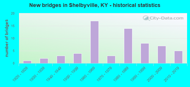
- New bridges - historical statistics
- 11920-1929
- 21930-1939
- 31940-1949
- 41950-1959
- 171960-1969
- 31970-1979
- 141980-1989
- 81990-1999
- 72000-2009
- 52010-2019

- Reconstructed bridges - Historical Statistics
- 11960-1969
- 01970-1979
- 01980-1989
- 01990-1999
- 22000-2009


- Bridge Condition - Deck
- 35.4%Good
- 31.3%Satisfactory
- 22.9%Fair
- 10.4%Poor

- Bridge Condition - Superstructure
- 2.1%Very good
- 25.0%Good
- 47.9%Satisfactory
- 18.8%Fair
- 4.2%Poor
- 2.1%Imminent failure

- Bridge Condition - Substructure
- 29.2%Good
- 37.5%Satisfactory
- 25.0%Fair
- 6.3%Poor
- 2.1%Imminent failure

- Bridge Condition - Channel
- 28.6%Good
- 51.0%Satisfactory
- 20.4%Fair

- Bridge Condition - Culverts
- 11.1%Good
- 44.4%Satisfactory
- 44.4%Fair
Find on map >> Show street view
Structure Number: 106C00047N, Location: 0.1 MI N OF US 60 WB (Lat: 38.212500, Lng: -85.215000), Route carried "on" structure: County highway 1329, Year Built: 1982, Status: Closed, Structure Length: 2.77m (9.09ft), Average Daily Traffic: 145 (year 2006), Average Future Daily Traffic: 199 (year 2026), Features Intersected: CLEAR CREEK, Facility Carried by Structure: JAIL HILL RD
Minimum Vertical Clearance: 30+ m (98+ ft), Kilometerpoint: 0.650, Lanes on structure: 1, Owner: County Highway Agency, Approaching Roadway Width: 5.1m (16.7ft), Material/Design: Steel, Design/Construction: Truss - Thru, Number Of Spans In Main Unit: 1, Length of Maximum Span: 27.1m (88.9ft), Curb or Sidewalk Widths: Left: 0.3m (1.0ft), Right: 0.3m (1.0ft), Curb-To-Curb Width: 3.2m (10.5ft), Out-to-Out Width: 3.8m (12.5ft)
Condition: Deck: Satisfactory, Superstructure: Imminent failure, Substructure: Imminent failure, Channel: Satisfactory, Waterway Adequacy: Superior to present desirable criteria, Approach Roadway Alignment: High priority of corrective action, Bridge Posting: Required (Relationship of Operating Rating to Maximum Legal Load: > 39.9% below), Length Of Structure Improvement: 0.28m (0.92ft), Designated Inspection Frequency: Every 12 months, Inspection Date: April 2021, Bridge Improvement Cost: $224,000, Roadway Improvement Cost: $21,000, Total Project Cost: $244,000, Deck Structure Type: Wood or Timber, Wearing Surface/Protective System: Wearing Surface: Wood or Timber
Find on map >> Show street view
Structure Number: 106C00049N, Location: 1.5 MI S OF KY 362 (Lat: 38.272778, Lng: -85.289444), Route carried "on" structure: County highway 1310, Year Built: 1985, Status: Open, Structure Length: 1.92m (6.30ft), Average Daily Traffic: 71 (year 2014), Average Future Daily Traffic: 2,034 (year 2034), Design Load: HS 20, Features Intersected: BULLSKIN CREEK, Facility Carried by Structure: HEBRON RD
Minimum Vertical Clearance: 30+ m (98+ ft), Kilometerpoint: 2.398, Lanes on structure: 2, Owner: County Highway Agency, Approaching Roadway Width: 5.5m (18.0ft), Skew: 1 degrees, Material/Design: Prestressed concrete, Design/Construction: Box Beam or Girders - Multiple, Number Of Spans In Main Unit: 1, Length of Maximum Span: 18.3m (60.0ft), Curb-To-Curb Width: 6.9m (22.6ft), Out-to-Out Width: 7.3m (24.0ft)
Condition: Deck: Good, Superstructure: Satisfactory, Substructure: Satisfactory, Channel: Satisfactory, Operating Rating: 87.4 metric tons, Method Used To Determine Operating Rating: Load Factor (LF), Inventory Rating: 52.4 metric tons, Method Used To Determine Inventory Rating: Load Factor (LF), Structural Evaluation: Equal to present minimum criteria, Deck Geometry: Somewhat better than minimum adequacy, Waterway Adequacy: Superior to present desirable criteria, Approach Roadway Alignment: Equal to present desirable criteria, Designated Inspection Frequency: Every 24 months, Inspection Date: April 2020, Deck Structure Type: Concrete Precast Panels, Wearing Surface/Protective System: Wearing Surface: Bituminous, Deck Protection: Epoxy Coated Reinforcing
Find on map >> Show street view
Structure Number: 106C00051N, Location: 2.2 MI E OF KY 362 (Lat: 38.263611, Lng: -85.302222), Route carried "on" structure: County highway 1312, Year Built: 1986, Status: Open, Structure Length: 1.71m (5.61ft), Average Daily Traffic: 299 (year 2014), Average Future Daily Traffic: 2,034 (year 2034), Design Load: HS 20, Features Intersected: BULLSKIN CREEK, Facility Carried by Structure: ANDERSON LN
Minimum Vertical Clearance: 30+ m (98+ ft), Kilometerpoint: 1.592, Lanes on structure: 2, Owner: County Highway Agency, Approaching Roadway Width: 4.6m (15.1ft), Skew: 3 degrees, Material/Design: Prestressed concrete, Design/Construction: Box Beam or Girders - Multiple, Number Of Spans In Main Unit: 1, Length of Maximum Span: 16.0m (52.5ft), Curb-To-Curb Width: 5.9m (19.4ft), Out-to-Out Width: 6.4m (21.0ft)
Condition: Deck: Satisfactory, Superstructure: Satisfactory, Substructure: Satisfactory, Channel: Satisfactory, Operating Rating: 62.2 metric tons, Method Used To Determine Operating Rating: Load Factor (LF), Inventory Rating: 37.3 metric tons, Method Used To Determine Inventory Rating: Load Factor (LF), Structural Evaluation: Equal to present minimum criteria, Deck Geometry: High priority of corrective action, Waterway Adequacy: Equal to present minimum criteria, Approach Roadway Alignment: Equal to present desirable criteria, Length Of Structure Improvement: 0.18m (0.59ft), Designated Inspection Frequency: Every 24 months, Inspection Date: April 2020, Bridge Improvement Cost: $158,000, Total Project Cost: $157,000, Deck Structure Type: Concrete Precast Panels, Wearing Surface/Protective System: Wearing Surface: Bituminous, Deck Protection: Epoxy Coated Reinforcing
Find on map >> Show street view
Structure Number: 106C00052N, Location: 2.9 MI E OF KY 1848 (Lat: 38.240833, Lng: -85.290000), Route carried "on" structure: County highway 1309, Year Built: 1986, Status: Open, Structure Length: 2.99m (9.81ft), Average Daily Traffic: 112 (year 2014), Average Future Daily Traffic: 2,034 (year 2034), Design Load: HS 20, Features Intersected: BULLSKIN CREEK, Facility Carried by Structure: ANTIOCH RD
Minimum Vertical Clearance: 30+ m (98+ ft), Kilometerpoint: 4.598, Lanes on structure: 2, Owner: County Highway Agency, Approaching Roadway Width: 4.9m (16.1ft), Material/Design: Prestressed concrete, Design/Construction: Box Beam or Girders - Multiple, Number Of Spans In Main Unit: 1, Length of Maximum Span: 29.0m (95.1ft), Curb-To-Curb Width: 5.9m (19.4ft), Out-to-Out Width: 6.4m (21.0ft)
Condition: Deck: Fair, Superstructure: Satisfactory, Substructure: Satisfactory, Channel: Satisfactory, Operating Rating: 85.9 metric tons, Method Used To Determine Operating Rating: Load Factor (LF), Inventory Rating: 51.5 metric tons, Method Used To Determine Inventory Rating: Load Factor (LF), Structural Evaluation: Equal to present minimum criteria, Deck Geometry: High priority of corrective action, Waterway Adequacy: Equal to present desirable criteria, Approach Roadway Alignment: Equal to present minimum criteria, Designated Inspection Frequency: Every 24 months, Inspection Date: April 2020, Deck Structure Type: Concrete Precast Panels, Wearing Surface/Protective System: Wearing Surface: Monolithic Concrete, Deck Protection: Epoxy Coated Reinforcing
Find on map >> Show street view
Structure Number: 106C00054N, Location: 1.6 MI W OF KY 55 (Lat: 38.274167, Lng: -85.233333), Route carried "on" structure: County highway 1301, Year Built: 1987, Status: Open, Structure Length: 1.92m (6.30ft), Average Daily Traffic: 67 (year 2014), Average Future Daily Traffic: 2,034 (year 2034), Design Load: HS 20, Features Intersected: FOX RUN, Facility Carried by Structure: FOX RUN RD
Minimum Vertical Clearance: 30+ m (98+ ft), Kilometerpoint: 1.996, Lanes on structure: 2, Owner: County Highway Agency, Approaching Roadway Width: 5.2m (17.1ft), Skew: 1 degrees, Material/Design: Prestressed concrete, Design/Construction: Box Beam or Girders - Multiple, Number Of Spans In Main Unit: 1, Length of Maximum Span: 18.3m (60.0ft), Curb-To-Curb Width: 9.3m (30.5ft), Out-to-Out Width: 9.8m (32.2ft)
Condition: Deck: Satisfactory, Superstructure: Satisfactory, Substructure: Fair, Channel: Good, Operating Rating: 56.4 metric tons, Method Used To Determine Operating Rating: Load Factor (LF), Inventory Rating: 33.8 metric tons, Method Used To Determine Inventory Rating: Load Factor (LF), Structural Evaluation: Somewhat better than minimum adequacy, Deck Geometry: Better than present minimum criteria, Waterway Adequacy: Better than present minimum criteria, Approach Roadway Alignment: Equal to present minimum criteria, Designated Inspection Frequency: Every 24 months, Inspection Date: April 2020, Deck Structure Type: Concrete Precast Panels, Wearing Surface/Protective System: Wearing Surface: Bituminous, Deck Protection: Epoxy Coated Reinforcing
Find on map >> Show street view
Structure Number: 106C00056N, Location: 2.2 MI S OF KY 53 (Lat: 38.158889, Lng: -85.182500), Route carried "on" structure: County highway 1116, Year Built: 1988, Status: Open, Structure Length: 2.33m (7.64ft), Average Daily Traffic: 250 (year 2010), Average Future Daily Traffic: 217 (year 2030), Design Load: HS 25 or greater, Features Intersected: GUIST CREEK, Facility Carried by Structure: ROCKBRIDGE RD
Minimum Vertical Clearance: 30+ m (98+ ft), Kilometerpoint: 5.201, Lanes on structure: 2, Owner: County Highway Agency, Approaching Roadway Width: 5.5m (18.0ft), Material/Design: Prestressed concrete, Design/Construction: Box Beam or Girders - Multiple, Number Of Spans In Main Unit: 1, Length of Maximum Span: 22.9m (75.1ft), Curb-To-Curb Width: 6.9m (22.6ft), Out-to-Out Width: 7.3m (24.0ft)
Condition: Deck: Satisfactory, Superstructure: Good, Substructure: Satisfactory, Channel: Satisfactory, Operating Rating: 77.7 metric tons, Method Used To Determine Operating Rating: Load Factor (LF), Inventory Rating: 46.6 metric tons, Method Used To Determine Inventory Rating: Load Factor (LF), Structural Evaluation: Equal to present minimum criteria, Deck Geometry: Meets minimum limits, Waterway Adequacy: Equal to present desirable criteria, Approach Roadway Alignment: Equal to present desirable criteria, Designated Inspection Frequency: Every 24 months, Inspection Date: April 2020, Deck Structure Type: Concrete Precast Panels, Wearing Surface/Protective System: Wearing Surface: Monolithic Concrete, Deck Protection: Epoxy Coated Reinforcing
Find on map >> Show street view
Structure Number: 106C00059N, Location: 1.5 MI E OF KY 55 (Lat: 38.268333, Lng: -85.177500), Route carried "on" structure: County highway 1003, Year Built: 1989, Status: Open, Structure Length: 2.38m (7.81ft), Average Daily Traffic: 106 (year 2014), Average Future Daily Traffic: 2,034 (year 2034), Design Load: HS 25 or greater, Features Intersected: CLEAR CREEK, Facility Carried by Structure: CLEAR CREEK RD
Minimum Vertical Clearance: 30+ m (98+ ft), Kilometerpoint: 2.375, Lanes on structure: 2, Owner: County Highway Agency, Approaching Roadway Width: 5.2m (17.1ft), Material/Design: Prestressed concrete, Design/Construction: Box Beam or Girders - Multiple, Number Of Spans In Main Unit: 1, Length of Maximum Span: 22.9m (75.1ft), Curb-To-Curb Width: 6.9m (22.6ft), Out-to-Out Width: 7.3m (24.0ft)
Condition: Deck: Good, Superstructure: Satisfactory, Substructure: Satisfactory, Channel: Good, Operating Rating: 68.8 metric tons, Method Used To Determine Operating Rating: Load Factor (LF), Inventory Rating: 41.3 metric tons, Method Used To Determine Inventory Rating: Load Factor (LF), Structural Evaluation: Equal to present minimum criteria, Deck Geometry: Meets minimum limits, Waterway Adequacy: Equal to present desirable criteria, Approach Roadway Alignment: Meets minimum limits, Designated Inspection Frequency: Every 24 months, Inspection Date: April 2020, Deck Structure Type: Concrete Precast Panels, Wearing Surface/Protective System: Wearing Surface: Bituminous, Deck Protection: Epoxy Coated Reinforcing
Find on map >> Show street view
Structure Number: 106C00060N, Location: 0.6 MI W OF KY 1871 (Lat: 38.217500, Lng: -85.188611), Route carried "on" structure: County highway 1001, Year Built: 1991, Status: Posted for load, Structure Length: 1.52m (4.99ft), Average Daily Traffic: 2,685 (year 2019), Average Future Daily Traffic: 2,497 (year 2039), Design Load: HS 20, Features Intersected: TRIB TO CLEAR CREEK, Facility Carried by Structure: BENSON PIKE
Minimum Vertical Clearance: 30+ m (98+ ft), Kilometerpoint: 1.587, Lanes on structure: 2, Owner: County Highway Agency, Approaching Roadway Width: 6.4m (21.0ft), Skew: 4 degrees, Material/Design: Prestressed concrete, Design/Construction: Box Beam or Girders - Multiple, Number Of Spans In Main Unit: 1, Length of Maximum Span: 14.8m (48.6ft), Curb-To-Curb Width: 6.9m (22.6ft), Out-to-Out Width: 7.3m (24.0ft)
Condition: Deck: Fair, Superstructure: Fair, Substructure: Good, Channel: Satisfactory, Operating Rating: 43.9 metric tons, Method Used To Determine Operating Rating: Load Factor (LF), Inventory Rating: 26.3 metric tons, Method Used To Determine Inventory Rating: Load Factor (LF), Structural Evaluation: Somewhat better than minimum adequacy, Deck Geometry: High priority of replacement, Waterway Adequacy: Better than present minimum criteria, Approach Roadway Alignment: Equal to present desirable criteria, Bridge Posting: Required (Relationship of Operating Rating to Maximum Legal Load: 0.1 - 9.9% below), Designated Inspection Frequency: Every 24 months, Inspection Date: April 2020, Deck Structure Type: Concrete Precast Panels, Wearing Surface/Protective System: Wearing Surface: Monolithic Concrete, Deck Protection: Epoxy Coated Reinforcing
Find on map >> Show street view
Structure Number: 106C00066N, Location: 250 FT S OF CLEAR CR RD (Lat: 38.268611, Lng: -85.176111), Route carried "on" structure: County highway 1002, Year Built: 1992, Status: Open, Structure Length: 1.22m (4.00ft), Average Daily Traffic: 189 (year 2014), Average Future Daily Traffic: 2,034 (year 2034), Design Load: HS 25 or greater, Features Intersected: E CLEAR CREEK, Facility Carried by Structure: BELLVIEW RD
Minimum Vertical Clearance: 30+ m (98+ ft), Kilometerpoint: 4.065, Lanes on structure: 2, Owner: County Highway Agency, Approaching Roadway Width: 4.7m (15.4ft), Material/Design: Prestressed concrete, Design/Construction: Box Beam or Girders - Multiple, Number Of Spans In Main Unit: 1, Length of Maximum Span: 11.3m (37.1ft), Curb-To-Curb Width: 6.9m (22.6ft), Out-to-Out Width: 7.3m (24.0ft)
Condition: Deck: Satisfactory, Superstructure: Satisfactory, Substructure: Satisfactory, Channel: Satisfactory, Operating Rating: 67.2 metric tons, Method Used To Determine Operating Rating: Load Factor (LF), Inventory Rating: 40.3 metric tons, Method Used To Determine Inventory Rating: Load Factor (LF), Structural Evaluation: Equal to present minimum criteria, Deck Geometry: Meets minimum limits, Waterway Adequacy: Equal to present desirable criteria, Approach Roadway Alignment: Equal to present minimum criteria, Designated Inspection Frequency: Every 24 months, Inspection Date: April 2020, Deck Structure Type: Concrete Precast Panels, Wearing Surface/Protective System: Wearing Surface: Monolithic Concrete, Deck Protection: Epoxy Coated Reinforcing
Find on map >> Show street view
Structure Number: 106C00070N, Location: 0.5 MI E OF KY 55 (Lat: 38.217222, Lng: -85.196944), Route carried "on" structure: County highway 1001, Year Built: 1993, Status: Open, Structure Length: 1.28m (4.20ft), Average Daily Traffic: 2,685 (year 2019), Average Future Daily Traffic: 2,497 (year 2039), Design Load: HS 25 or greater, Features Intersected: TRIB TO CLEAR CREEK, Facility Carried by Structure: BENSON PIKE
Minimum Vertical Clearance: 30+ m (98+ ft), Kilometerpoint: 0.850, Lanes on structure: 2, Owner: County Highway Agency, Approaching Roadway Width: 6.1m (20.0ft), Skew: 3 degrees, Material/Design: Prestressed concrete, Design/Construction: Box Beam or Girders - Multiple, Number Of Spans In Main Unit: 1, Length of Maximum Span: 12.3m (40.4ft), Curb-To-Curb Width: 6.9m (22.6ft), Out-to-Out Width: 7.3m (24.0ft)
Condition: Deck: Satisfactory, Superstructure: Good, Substructure: Satisfactory, Channel: Satisfactory, Operating Rating: 68.0 metric tons, Method Used To Determine Operating Rating: Load Factor (LF), Inventory Rating: 40.8 metric tons, Method Used To Determine Inventory Rating: Load Factor (LF), Structural Evaluation: Equal to present minimum criteria, Deck Geometry: High priority of replacement, Waterway Adequacy: Equal to present desirable criteria, Approach Roadway Alignment: Equal to present minimum criteria, Designated Inspection Frequency: Every 24 months, Inspection Date: April 2020, Deck Structure Type: Concrete Precast Panels, Wearing Surface/Protective System: Wearing Surface: Monolithic Concrete, Deck Protection: Epoxy Coated Reinforcing
Find on map >> Show street view
Structure Number: 106C00079N, Location: 175 FT E OF KY 55 (Lat: 38.197222, Lng: -85.267222), Route carried "on" structure: County highway 1247, Year Built: 1996, Status: Open, Structure Length: 1.28m (4.20ft), Average Daily Traffic: 295 (year 2006), Average Future Daily Traffic: 406 (year 2026), Design Load: HS 25 or greater, Features Intersected: DRY RUN, Facility Carried by Structure: OLD BRUNERSTOWN RD
Minimum Vertical Clearance: 30+ m (98+ ft), Kilometerpoint: 1.326, Lanes on structure: 2, Owner: County Highway Agency, Approaching Roadway Width: 6.7m (22.0ft), Skew: 3 degrees, Material/Design: Prestressed concrete, Design/Construction: Box Beam or Girders - Multiple, Number Of Spans In Main Unit: 1, Length of Maximum Span: 12.3m (40.4ft), Curb-To-Curb Width: 6.9m (22.6ft), Out-to-Out Width: 7.3m (24.0ft)
Condition: Deck: Good, Superstructure: Satisfactory, Substructure: Satisfactory, Channel: Satisfactory, Operating Rating: 52.3 metric tons, Method Used To Determine Operating Rating: Load Factor (LF), Inventory Rating: 31.4 metric tons, Method Used To Determine Inventory Rating: Load Factor (LF), Structural Evaluation: Equal to present minimum criteria, Deck Geometry: Meets minimum limits, Waterway Adequacy: Superior to present desirable criteria, Approach Roadway Alignment: Equal to present desirable criteria, Designated Inspection Frequency: Every 24 months, Inspection Date: April 2020, Deck Structure Type: Concrete Precast Panels, Wearing Surface/Protective System: Wearing Surface: Bituminous, Deck Protection: Epoxy Coated Reinforcing
Find on map >> Show street view
Structure Number: 106C00081N, Location: 2.9 MI S OF KY 53 (Lat: 38.149444, Lng: -85.176667), Route carried "on" structure: County highway 1116, Year Built: 1997, Status: Open, Structure Length: 2.30m (7.55ft), Average Daily Traffic: 121 (year 2010), Average Future Daily Traffic: 105 (year 2030), Design Load: HS 25 or greater, Features Intersected: JEPTHA CREEK, Facility Carried by Structure: ROCKBRIDGE RD
Minimum Vertical Clearance: 30+ m (98+ ft), Kilometerpoint: 3.932, Lanes on structure: 2, Owner: County Highway Agency, Approaching Roadway Width: 5.5m (18.0ft), Material/Design: Prestressed concrete, Design/Construction: Box Beam or Girders - Multiple, Number Of Spans In Main Unit: 1, Length of Maximum Span: 22.5m (73.8ft), Curb-To-Curb Width: 6.8m (22.3ft), Out-to-Out Width: 7.3m (24.0ft)
Condition: Deck: Satisfactory, Superstructure: Satisfactory, Substructure: Satisfactory, Channel: Fair, Operating Rating: 85.0 metric tons, Method Used To Determine Operating Rating: Load Factor (LF), Inventory Rating: 51.0 metric tons, Method Used To Determine Inventory Rating: Load Factor (LF), Structural Evaluation: Equal to present minimum criteria, Deck Geometry: Meets minimum limits, Waterway Adequacy: Better than present minimum criteria, Approach Roadway Alignment: Equal to present desirable criteria, Designated Inspection Frequency: Every 24 months, Inspection Date: April 2020, Deck Structure Type: Concrete Precast Panels, Wearing Surface/Protective System: Wearing Surface: Bituminous, Membrane: Preformed Fabric, Deck Protection: Epoxy Coated Reinforcing
Find on map >> Show street view
Structure Number: 106C00083N, Location: 100 FT E OF KY 55 (Lat: 38.209444, Lng: -85.261944), Route carried "on" structure: County highway 1239, Year Built: 1998, Status: Open, Structure Length: 0.76m (2.49ft), Average Daily Traffic: 1,710 (year 2006), Average Future Daily Traffic: 2,352 (year 2026), Design Load: HS 25 or greater, Features Intersected: DRY RUN, Facility Carried by Structure: BROOKS INDUSTRIAL
Minimum Vertical Clearance: 30+ m (98+ ft), Kilometerpoint: 0.039, Lanes on structure: 2, Owner: County Highway Agency, Approaching Roadway Width: 11.0m (36.1ft), Material/Design: Concrete, Design/Construction: Culvert, Number Of Spans In Main Unit: 2, Length of Maximum Span: 3.7m (12.1ft), Curb-To-Curb Width: 15.9m (52.2ft), Out-to-Out Width: 16.4m (53.8ft)
Condition: Channel: Satisfactory, Culverts: Satisfactory, Operating Rating: 54.4 metric tons, Method Used To Determine Operating Rating: Field evaluation and documented engineering judgment, Inventory Rating: 39.9 metric tons, Method Used To Determine Inventory Rating: Field evaluation and documented engineering judgment, Structural Evaluation: Equal to present minimum criteria, Deck Geometry: Superior to present desirable criteria, Waterway Adequacy: Equal to present desirable criteria, Approach Roadway Alignment: Equal to present minimum criteria, Designated Inspection Frequency: Every 24 months, Inspection Date: April 2020
Find on map >> Show street view
Structure Number: 106C00085N, Location: 0.5 MI W OF KY 2861 (Lat: 38.131667, Lng: -85.270556), Route carried "on" structure: County highway 1207, Year Built: 2007, Status: Open, Structure Length: 0.91m (2.99ft), Average Daily Traffic: 54 (year 2010), Average Future Daily Traffic: 46 (year 2030), Design Load: HS 25 or greater, Features Intersected: WISE RUN, Facility Carried by Structure: OLIVE BRANCH RD
Minimum Vertical Clearance: 30+ m (98+ ft), Kilometerpoint: 1.326, Lanes on structure: 2, Owner: County Highway Agency, Approaching Roadway Width: 4.9m (16.1ft), Skew: 3 degrees, Material/Design: Prestressed concrete, Design/Construction: Box Beam or Girders - Multiple, Number Of Spans In Main Unit: 1, Length of Maximum Span: 9.1m (29.9ft), Curb-To-Curb Width: 6.9m (22.6ft), Out-to-Out Width: 7.3m (24.0ft)
Condition: Deck: Good, Superstructure: Good, Substructure: Good, Channel: Satisfactory, Operating Rating: 99.8 metric tons, Method Used To Determine Operating Rating: Load Factor (LF), Inventory Rating: 62.5 metric tons, Method Used To Determine Inventory Rating: Load Factor (LF), Structural Evaluation: Better than present minimum criteria, Deck Geometry: Somewhat better than minimum adequacy, Waterway Adequacy: Equal to present desirable criteria, Approach Roadway Alignment: Equal to present minimum criteria, Designated Inspection Frequency: Every 24 months, Inspection Date: April 2020, Deck Structure Type: Concrete Precast Panels, Wearing Surface/Protective System: Wearing Surface: Bituminous, Deck Protection: Epoxy Coated Reinforcing
Find on map >> Show street view
Structure Number: 106C00087N, Location: 0.5 MI E OF BURKS BR RD (Lat: 38.233333, Lng: -85.219444), Route carried "on" structure: City street 1177, Year Built: 1987, Status: Posted for load, Structure Length: 0.91m (2.99ft), Average Daily Traffic: 50 (year 2009), Average Future Daily Traffic: 50 (year 2029), Features Intersected: TRIB TO SHELBY LAKE, Facility Carried by Structure: DON CUBERT DR
Minimum Vertical Clearance: 30+ m (98+ ft), Kilometerpoint: 0.814, Lanes on structure: 2, Owner: City or Municipal Highway Agency, Approaching Roadway Width: 6.7m (22.0ft), Material/Design: Steel, Design/Construction: Stringer/Multi-beam, Number Of Spans In Main Unit: 1, Length of Maximum Span: 8.2m (26.9ft), Curb-To-Curb Width: 8.1m (26.6ft), Out-to-Out Width: 8.4m (27.6ft)
Condition: Deck: Fair, Superstructure: Fair, Substructure: Satisfactory, Channel: Good, Operating Rating: 36.5 metric tons, Method Used To Determine Operating Rating: Load Factor (LF), Inventory Rating: 21.9 metric tons, Method Used To Determine Inventory Rating: Load Factor (LF), Structural Evaluation: Somewhat better than minimum adequacy, Deck Geometry: Equal to present minimum criteria, Waterway Adequacy: Better than present minimum criteria, Approach Roadway Alignment: Better than present minimum criteria, Bridge Posting: Required (Relationship of Operating Rating to Maximum Legal Load: > 39.9% below), Designated Inspection Frequency: Every 24 months, Inspection Date: April 2020, Deck Structure Type: Open Grating, Wearing Surface/Protective System: Wearing Surface: Other
Find on map >> Show street view
Structure Number: 106C00091N, Location: 0.55 MI E OF KY 55 (Lat: 38.190556, Lng: -85.266944), Route carried "on" structure: City street 1181, Year Built: 2015, Status: Open, Structure Length: 1.40m (4.59ft), Average Daily Traffic: 210 (year 2017), Average Future Daily Traffic: 256 (year 2037), Design Load: Greater than HL93, Features Intersected: DRY RUN, Facility Carried by Structure: GORDON LN
Minimum Vertical Clearance: 30+ m (98+ ft), Kilometerpoint: 0.217, Lanes on structure: 2, Owner: City or Municipal Highway Agency, Approaching Roadway Width: 7.0m (23.0ft), Skew: 3 degrees, Material/Design: Prestressed concrete, Design/Construction: Box Beam or Girders - Multiple, Number Of Spans In Main Unit: 1, Length of Maximum Span: 12.8m (42.0ft), Curb or Sidewalk Widths: Left: 0.0m, Right: 1.8m (5.9ft), Curb-To-Curb Width: 10.4m (34.1ft), Out-to-Out Width: 11.0m (36.1ft)
Condition: Deck: Good, Superstructure: Satisfactory, Substructure: Good, Channel: Good, Operating Rating: 65.4 metric tons, Method Used To Determine Operating Rating: Load and Resistance Factor Rating (LRFR) rating reported by rating factor(RF) method using HL-93 loadings, Inventory Rating: 50.5 metric tons, Method Used To Determine Inventory Rating: Load and Resistance Factor Rating (LRFR) rating reported by rating factor(RF) method using HL-93 loadings, Structural Evaluation: Equal to present minimum criteria, Deck Geometry: Better than present minimum criteria, Waterway Adequacy: Better than present minimum criteria, Approach Roadway Alignment: Equal to present minimum criteria, Designated Inspection Frequency: Every 24 months, Inspection Date: April 2020, Deck Structure Type: Concrete Cast-file-Place, Wearing Surface/Protective System: Wearing Surface: Bituminous, Deck Protection: Epoxy Coated Reinforcing
Find on map >> Show street view
Structure Number: 106B00009N, Location: 1.9 MI S OF US 60 (Lat: 38.184722, Lng: -85.212222), Route carried "under" structure: Interstate 64, Year Built: 1960, Structure Length: 0. m, Average Daily Traffic: 41,274 (year 2020), Truck Traffic: 20%, Features Intersected: I-64, Facility Carried by Structure: KY 53
Minimum Vertical Clearance: 5.11m (16.77ft), Kilometerpoint: 56.515, Lanes on structure: 2, Lanes under structure: 4, Material/Design: Concrete continuous, Design/Construction: Tee Beam, Length of Maximum Span: 24.4m (80.1ft)
Find on map >> Show street view
Structure Number: 106B00019N, Location: 0.6 MI S OF US 60 (Lat: 38.206111, Lng: -85.264444), Route carried "under" structure: State highway 55, Year Built: 1960, Structure Length: 0. m, Average Daily Traffic: 19,117 (year 2013), Truck Traffic: 10%, Features Intersected: KY 55, Facility Carried by Structure: NS RAILROAD
Minimum Vertical Clearance: 5.08m (16.67ft), Kilometerpoint: 11.780, Lanes under structure: 4, Material/Design: Steel, Design/Construction: Stringer/Multi-beam, Length of Maximum Span: 17.7m (58.1ft)
Find on map >> Show street view
Structure Number: 106B00039N, Location: 1.9 MI S OF US 60 (Lat: 38.185278, Lng: -85.239444), Route carried "under" structure: Interstate 64, Year Built: 1960, Structure Length: 0. m, Average Daily Traffic: 41,274 (year 2020), Truck Traffic: 20%, Features Intersected: I-64, Facility Carried by Structure: KY 2861
Minimum Vertical Clearance: 4.90m (16.08ft), Kilometerpoint: 54.135, Lanes on structure: 2, Lanes under structure: 4, Material/Design: Concrete continuous, Design/Construction: Tee Beam, Length of Maximum Span: 22.9m (75.1ft)
Find on map >> Show street view
Structure Number: 106B00047N, Location: 1.0 MI W OF KY 714 (Lat: 38.173056, Lng: -85.159444), Route carried "under" structure: Interstate 64, Year Built: 1960, Structure Length: 0. m, Average Daily Traffic: 38,204 (year 2020), Truck Traffic: 22%, Features Intersected: I-64, Facility Carried by Structure: KY 1790
Minimum Vertical Clearance: 4.95m (16.24ft), Kilometerpoint: 61.359, Lanes on structure: 2, Lanes under structure: 4, Material/Design: Concrete, Design/Construction: Tee Beam, Length of Maximum Span: 17.3m (56.8ft)
Find on map >> Show street view
Structure Number: 106B00109N, Location: 1.55 MI S OF US 60 (Lat: 38.192222, Lng: -85.271667), Route carried "under" structure: Interstate 64, Year Built: 2013, Structure Length: 0. m, Average Daily Traffic: 50,900 (year 2011), Truck Traffic: 17%, Features Intersected: I-64, Facility Carried by Structure: KY 55
Minimum Vertical Clearance: 5.49m (18.01ft), Kilometerpoint: 51.196, Lanes on structure: 4, Lanes under structure: 6, Material/Design: Prestressed concrete continuous, Design/Construction: Stringer/Multi-beam, Length of Maximum Span: 44.2m (145.0ft)
Find on map >> Show street view
Structure Number: 106R00600N, Location: 0.15 MI N OF US 60 WB (Lat: 38.214444, Lng: -85.218611), Route carried "under" structure: City street 1001, Year Built: 1924, Structure Length: 0. m, Average Daily Traffic: 5,142 (year 2019), Features Intersected: 7TH ST, Facility Carried by Structure: RJ CORMAN RAILROAD
Minimum Vertical Clearance: 4.47m (14.67ft), Kilometerpoint: 0.150, Lanes under structure: 2, Material/Design: Steel, Design/Construction: Girder and Floorbeam System, Length of Maximum Span: 19.5m (64.0ft)
Find on map >> Show street view
Structure Number: 106R00604N, Location: 0.15 MI S OF US 60 EB (Lat: 38.208889, Lng: -85.213056), Route carried "under" structure: City street 1122, Year Built: 1950, Structure Length: 0. m, Average Daily Traffic: 1,307 (year 2019), Features Intersected: 3RD ST, Facility Carried by Structure: NS RAILROAD
Minimum Vertical Clearance: 3.71m (12.17ft), Kilometerpoint: 0.356, Lanes under structure: 2, Material/Design: Steel, Design/Construction: Girder and Floorbeam System, Length of Maximum Span: 10.7m (35.1ft)