Bridge Statistics for Slidell, Louisiana (LA)
Condition, Traffic, Stress, Structural Evaluation, Project Costs
- National Bridge Inventory (NBI) Statistics
- 125Number of bridges
- 1,900ft / 579mTotal length
- $31,696,000Total costs
- 2,512,800Total average daily traffic
- 294,623Total average daily truck traffic
- National Bridge Inventory (NBI) Registered Bridges for Slidell
- No street view available for this location
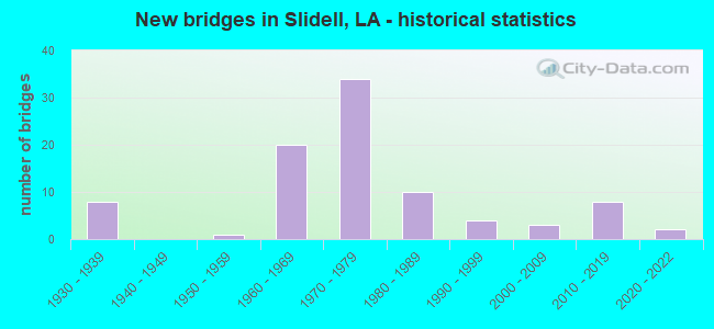
- New bridges - historical statistics
- 81930-1939
- 11950-1959
- 201960-1969
- 341970-1979
- 101980-1989
- 41990-1999
- 32000-2009
- 82010-2019
- 22020-2022

- Reconstructed bridges - Historical Statistics
- 11950-1959
- 01960-1969
- 01970-1979
- 01980-1989
- 01990-1999
- 42000-2009


- Bridge Condition - Deck
- 2.6%Excellent
- 5.3%Very good
- 48.7%Good
- 42.1%Satisfactory
- 1.3%Fair

- Bridge Condition - Superstructure
- 2.6%Excellent
- 13.2%Very good
- 38.2%Good
- 42.1%Satisfactory
- 1.3%Fair
- 2.6%Poor

- Bridge Condition - Substructure
- 2.6%Excellent
- 17.1%Very good
- 44.7%Good
- 31.6%Satisfactory
- 1.3%Fair
- 2.6%Poor

- Bridge Condition - Channel
- 20.5%Very good
- 49.3%Good
- 20.5%Satisfactory
- 9.6%Fair

- Bridge Condition - Culverts
- 50.0%Good
- 50.0%Satisfactory
Find on map >> Show street view
Structure Number: 625204530100311, Location: 0.2 M N OF I-12 (Lat: 30.310361, Lng: -89.739600), Route carried "on" structure: County highway , Year Built: 1966, Status: Open, Structure Length: 8.08m (26.51ft), Average Daily Traffic: 20,400 (year 2015), Average Future Daily Traffic: 15,504 (year 2036), Design Load: HS 20, Features Intersected: I-59, Facility Carried by Structure: BROWNSWITCH RD
Minimum Vertical Clearance: 30+ m (98+ ft), Kilometerpoint: 1.305, Lanes on structure: 2, Lanes under structure: 5, Base Highway Network: Yes (Inventory Route: 453-01-1, Subroute: 10), Owner: State Highway Agency, Approaching Roadway Width: 9.8m (32.2ft), Material/Design: Steel, Design/Construction: Stringer/Multi-beam, Number Of Spans In Main Unit: 2, Number Of Approach Spans: 2, Length of Maximum Span: 27.4m (89.9ft), Curb-To-Curb Width: 7.3m (24.0ft), Out-to-Out Width: 9.1m (29.9ft)
Condition: Deck: Good, Superstructure: Good, Substructure: Good, Operating Rating: 42.6 metric tons, Method Used To Determine Operating Rating: Load Factor (LF), Inventory Rating: 25.4 metric tons, Method Used To Determine Inventory Rating: Load Factor (LF), Structural Evaluation: Equal to present minimum criteria, Deck Geometry: High priority of replacement, Underclear: Somewhat better than minimum adequacy, Approach Roadway Alignment: Equal to present desirable criteria, Length Of Structure Improvement: 8.99m (29.49ft), Designated Inspection Frequency: Every 24 months, Inspection Date: August 2021, Bridge Improvement Cost: $767,000, Total Project Cost: $1,150,000 ( Estimate for 2016), Deck Structure Type: Concrete Cast-file-Place
Find on map >> Show street view
Structure Number: 625204540426911, Location: I0012 (Lat: 30.316639, Lng: -89.835900), Route carried "on" structure: Interstate 12, Year Built: 1972, Status: Open, Structure Length: 4.88m (16.01ft), Average Daily Traffic: 22,200 (year 2016), Truck Traffic: 26%, Average Future Daily Traffic: 20,292 (year 2036), Design Load: HS 20, Features Intersected: BAYOU LIBERTY
Minimum Vertical Clearance: 30+ m (98+ ft), Kilometerpoint: 43.520, Lanes on structure: 2, Base Highway Network: Yes (Inventory Route: 454-04-1, Subroute: 10), Owner: State Highway Agency, Approaching Roadway Width: 12.2m (40.0ft), Skew: 1 degrees, Material/Design: Prestressed concrete, Design/Construction: Stringer/Multi-beam, Number Of Spans In Main Unit: 3, Length of Maximum Span: 16.2m (53.1ft), Curb-To-Curb Width: 12.2m (40.0ft), Out-to-Out Width: 12.9m (42.3ft)
Condition: Deck: Good, Superstructure: Good, Substructure: Good, Channel: Good, Operating Rating: 77.1 metric tons, Method Used To Determine Operating Rating: Load Factor (LF), Inventory Rating: 40.8 metric tons, Method Used To Determine Inventory Rating: Load Factor (LF), Structural Evaluation: Better than present minimum criteria, Deck Geometry: Better than present minimum criteria, Waterway Adequacy: Equal to present desirable criteria, Approach Roadway Alignment: Equal to present desirable criteria, Designated Inspection Frequency: Every 24 months, Inspection Date: August 2021, Deck Structure Type: Concrete Cast-file-Place
Find on map >> Show street view
Structure Number: 625204540426912, Location: I0012 (Lat: 30.316739, Lng: -89.835400), Route carried "on" structure: Interstate 12, Year Built: 1972, Status: Open, Structure Length: 4.88m (16.01ft), Average Daily Traffic: 22,200 (year 2016), Truck Traffic: 26%, Average Future Daily Traffic: 20,292 (year 2036), Design Load: HS 20, Features Intersected: BAYOU LIBERTY
Minimum Vertical Clearance: 30+ m (98+ ft), Kilometerpoint: 10.345, Lanes on structure: 2, Base Highway Network: Yes (Inventory Route: 454-04-2, Subroute: 10), Owner: State Highway Agency, Approaching Roadway Width: 12.2m (40.0ft), Skew: 1 degrees, Material/Design: Prestressed concrete, Design/Construction: Stringer/Multi-beam, Number Of Spans In Main Unit: 3, Length of Maximum Span: 16.2m (53.1ft), Curb-To-Curb Width: 12.2m (40.0ft), Out-to-Out Width: 12.9m (42.3ft)
Condition: Deck: Good, Superstructure: Very good, Substructure: Very good, Channel: Good, Operating Rating: 77.1 metric tons, Method Used To Determine Operating Rating: Load Factor (LF), Inventory Rating: 40.8 metric tons, Method Used To Determine Inventory Rating: Load Factor (LF), Structural Evaluation: Equal to present desirable criteria, Deck Geometry: Better than present minimum criteria, Waterway Adequacy: Better than present minimum criteria, Approach Roadway Alignment: Equal to present desirable criteria, Designated Inspection Frequency: Every 24 months, Inspection Date: August 2021, Deck Structure Type: Concrete Cast-file-Place
Find on map >> Show street view
Structure Number: 625204540427561, Location: 6.2 M E OF LA 434 (Lat: 30.312831, Lng: -89.825900), Route carried "on" structure: County highway , Year Built: 1972, Status: Open, Structure Length: 8.69m (28.51ft), Average Daily Traffic: 4,450 (year 2015), Average Future Daily Traffic: 3,382 (year 2036), Design Load: HS 20, Features Intersected: I-12, Facility Carried by Structure: AIRPORT ROAD
Minimum Vertical Clearance: 30+ m (98+ ft), Kilometerpoint: 44.564, Lanes on structure: 2, Lanes under structure: 4, Base Highway Network: Yes (Inventory Route: 454-04-1, Subroute: 10), Owner: State Highway Agency, Approaching Roadway Width: 20.1m (65.9ft), Material/Design: Prestressed concrete, Design/Construction: Stringer/Multi-beam, Number Of Spans In Main Unit: 4, Length of Maximum Span: 29.0m (95.1ft), Curb-To-Curb Width: 12.2m (40.0ft), Out-to-Out Width: 13.1m (43.0ft)
Condition: Deck: Good, Superstructure: Good, Substructure: Good, Operating Rating: 80.7 metric tons, Method Used To Determine Operating Rating: Load Factor (LF), Inventory Rating: 35.4 metric tons, Method Used To Determine Inventory Rating: Load Factor (LF), Structural Evaluation: Better than present minimum criteria, Deck Geometry: Equal to present minimum criteria, Underclear: Somewhat better than minimum adequacy, Approach Roadway Alignment: Equal to present desirable criteria, Designated Inspection Frequency: Every 24 months, Inspection Date: August 2021, Deck Structure Type: Concrete Cast-file-Place
Find on map >> Show street view
Structure Number: 625204540429851, Location: I0012 (Lat: 30.310061, Lng: -89.787900), Route carried "on" structure: Interstate 12, Year Built: 1970, Status: Open, Structure Length: 12.98m (42.59ft), Average Daily Traffic: 28,550 (year 2016), Truck Traffic: 26%, Average Future Daily Traffic: 30,780 (year 2036), Design Load: HS 20, Features Intersected: DONYA ST/CANAL
Minimum Vertical Clearance: 30+ m (98+ ft), Kilometerpoint: 48.275, Lanes on structure: 3, Lanes under structure: 2, Base Highway Network: Yes (Inventory Route: 454-04-1, Subroute: 10), Owner: State Highway Agency, Approaching Roadway Width: 17.7m (58.1ft), Skew: 11 degrees, Material/Design: Prestressed concrete, Design/Construction: Stringer/Multi-beam, Number Of Spans In Main Unit: 6, Length of Maximum Span: 22.9m (75.1ft), Curb-To-Curb Width: 17.7m (58.1ft), Out-to-Out Width: 18.3m (60.0ft)
Condition: Deck: Good, Superstructure: Very good, Substructure: Very good, Channel: Very good, Operating Rating: 76.2 metric tons, Method Used To Determine Operating Rating: Load Factor (LF), Inventory Rating: 39.0 metric tons, Method Used To Determine Inventory Rating: Load Factor (LF), Structural Evaluation: Equal to present desirable criteria, Deck Geometry: Better than present minimum criteria, Underclear: Meets minimum limits, Waterway Adequacy: Equal to present desirable criteria, Approach Roadway Alignment: Equal to present desirable criteria, Designated Inspection Frequency: Every 24 months, Inspection Date: August 2021, Deck Structure Type: Concrete Cast-file-Place
Find on map >> Show street view
Structure Number: 625204540429852, Location: 0.9 M W OF US 11 (Lat: 30.310331, Lng: -89.786700), Route carried "on" structure: Interstate 12, Year Built: 1970, Status: Open, Structure Length: 12.98m (42.59ft), Average Daily Traffic: 28,550 (year 2016), Truck Traffic: 26%, Average Future Daily Traffic: 30,780 (year 2036), Design Load: HS 20, Features Intersected: I-12 OVER PAR RD ROLLINS
Minimum Vertical Clearance: 30+ m (98+ ft), Kilometerpoint: 5.520, Lanes on structure: 3, Lanes under structure: 2, Base Highway Network: Yes (Inventory Route: 454-04-2, Subroute: 10), Owner: State Highway Agency, Approaching Roadway Width: 17.7m (58.1ft), Skew: 11 degrees, Material/Design: Prestressed concrete, Design/Construction: Stringer/Multi-beam, Number Of Spans In Main Unit: 6, Length of Maximum Span: 22.9m (75.1ft), Curb-To-Curb Width: 17.7m (58.1ft), Out-to-Out Width: 18.3m (60.0ft)
Condition: Deck: Good, Superstructure: Very good, Substructure: Very good, Channel: Very good, Operating Rating: 76.2 metric tons, Method Used To Determine Operating Rating: Load Factor (LF), Inventory Rating: 39.0 metric tons, Method Used To Determine Inventory Rating: Load Factor (LF), Structural Evaluation: Equal to present desirable criteria, Deck Geometry: Better than present minimum criteria, Underclear: Meets minimum limits, Waterway Adequacy: Equal to present desirable criteria, Approach Roadway Alignment: Equal to present desirable criteria, Designated Inspection Frequency: Every 24 months, Inspection Date: August 2021, Deck Structure Type: Concrete Cast-file-Place
Find on map >> Show street view
Structure Number: 625204540430331, Location: I0012 (Lat: 30.310119, Lng: -89.780200), Route carried "on" structure: Interstate 12, Year Built: 1970, Year Reconstructed: 2013, Status: Open, Structure Length: 3.05m (10.01ft), Average Daily Traffic: 28,550 (year 2016), Truck Traffic: 26%, Average Future Daily Traffic: 25,946 (year 2036), Design Load: HS 20, Features Intersected: VINCENT BAYOU
Minimum Vertical Clearance: 30+ m (98+ ft), Kilometerpoint: 49.024, Lanes on structure: 3, Base Highway Network: Yes (Inventory Route: 454-04-1, Subroute: 10), Owner: State Highway Agency, Approaching Roadway Width: 18.6m (61.0ft), Skew: 10 degrees, Material/Design: Concrete, Design/Construction: Slab, Number Of Spans In Main Unit: 5, Length of Maximum Span: 6.1m (20.0ft), Curb-To-Curb Width: 18.6m (61.0ft), Out-to-Out Width: 19.4m (63.6ft)
Condition: Deck: Good, Superstructure: Good, Substructure: Satisfactory, Channel: Very good, Operating Rating: 68.9 metric tons, Method Used To Determine Operating Rating: Load Factor (LF), Inventory Rating: 41.7 metric tons, Method Used To Determine Inventory Rating: Load Factor (LF), Structural Evaluation: Equal to present minimum criteria, Deck Geometry: Superior to present desirable criteria, Waterway Adequacy: Better than present minimum criteria, Approach Roadway Alignment: Equal to present desirable criteria, Designated Inspection Frequency: Every 24 months, Inspection Date: August 2021, Deck Structure Type: Concrete Cast-file-Place, Wearing Surface/Protective System: Wearing Surface: Monolithic Concrete
Find on map >> Show street view
Structure Number: 625204540430332, Location: I0012 (Lat: 30.310381, Lng: -89.779800), Route carried "on" structure: Interstate 12, Year Built: 1970, Year Reconstructed: 2013, Status: Open, Structure Length: 3.05m (10.01ft), Average Daily Traffic: 28,550 (year 2016), Truck Traffic: 26%, Average Future Daily Traffic: 25,946 (year 2036), Design Load: HS 20, Features Intersected: VINCENT BAYOU
Minimum Vertical Clearance: 30+ m (98+ ft), Kilometerpoint: 4.862, Lanes on structure: 3, Base Highway Network: Yes (Inventory Route: 454-04-2, Subroute: 10), Owner: State Highway Agency, Approaching Roadway Width: 18.6m (61.0ft), Skew: 10 degrees, Material/Design: Concrete, Design/Construction: Slab, Number Of Spans In Main Unit: 5, Length of Maximum Span: 6.1m (20.0ft), Curb-To-Curb Width: 18.6m (61.0ft), Out-to-Out Width: 19.4m (63.6ft)
Condition: Deck: Good, Superstructure: Good, Substructure: Satisfactory, Channel: Very good, Operating Rating: 68.9 metric tons, Method Used To Determine Operating Rating: Load Factor (LF), Inventory Rating: 41.7 metric tons, Method Used To Determine Inventory Rating: Load Factor (LF), Structural Evaluation: Equal to present minimum criteria, Deck Geometry: Superior to present desirable criteria, Waterway Adequacy: Better than present minimum criteria, Approach Roadway Alignment: Equal to present desirable criteria, Designated Inspection Frequency: Every 24 months, Inspection Date: August 2021, Deck Structure Type: Concrete Cast-file-Place, Wearing Surface/Protective System: Wearing Surface: Monolithic Concrete
Find on map >> Show street view
Structure Number: 625204540430681, Location: I0012 (Lat: 30.310131, Lng: -89.771200), Route carried "on" structure: Interstate 12, Year Built: 1970, Year Reconstructed: 2013, Status: Open, Structure Length: 15.39m (50.49ft), Average Daily Traffic: 28,550 (year 2016), Truck Traffic: 26%, Average Future Daily Traffic: 25,946 (year 2036), Design Load: HS 20, Features Intersected: I-12 OVER US 11
Minimum Vertical Clearance: 30+ m (98+ ft), Kilometerpoint: 49.893, Lanes on structure: 4, Lanes under structure: 4, Base Highway Network: Yes (Inventory Route: 454-04-1, Subroute: 10), Owner: State Highway Agency, Approaching Roadway Width: 21.3m (69.9ft), Skew: 30 degrees, Material/Design: Steel, Design/Construction: Girder and Floorbeam System, Number Of Spans In Main Unit: 7, Length of Maximum Span: 40.8m (133.9ft), Curb-To-Curb Width: 21.0m (68.9ft), Out-to-Out Width: 21.9m (71.9ft)
Condition: Deck: Good, Superstructure: Good, Substructure: Very good, Channel: Very good, Operating Rating: 51.7 metric tons, Method Used To Determine Operating Rating: Load Factor (LF), Inventory Rating: 30.8 metric tons, Method Used To Determine Inventory Rating: Load Factor (LF), Structural Evaluation: Better than present minimum criteria, Deck Geometry: Better than present minimum criteria, Underclear: Equal to present minimum criteria, Waterway Adequacy: Equal to present desirable criteria, Approach Roadway Alignment: Equal to present desirable criteria, Designated Inspection Frequency: Every 24 months, Inspection Date: September 2021, Deck Structure Type: Concrete Cast-file-Place, Wearing Surface/Protective System: Wearing Surface: Monolithic Concrete
Find on map >> Show street view
Structure Number: 625204540430682, Location: I0012 (Lat: 30.310350, Lng: -89.769500), Route carried "on" structure: Interstate 12, Year Built: 1970, Year Reconstructed: 2013, Status: Open, Structure Length: 15.36m (50.39ft), Average Daily Traffic: 28,550 (year 2016), Truck Traffic: 26%, Average Future Daily Traffic: 25,946 (year 2036), Design Load: HS 20, Features Intersected: I-12 OVER US 11
Minimum Vertical Clearance: 30+ m (98+ ft), Kilometerpoint: 3.861, Lanes on structure: 4, Lanes under structure: 4, Base Highway Network: Yes (Inventory Route: 454-04-2, Subroute: 10), Owner: State Highway Agency, Approaching Roadway Width: 15.9m (52.2ft), Skew: 10 degrees, Material/Design: Steel, Design/Construction: Stringer/Multi-beam, Number Of Spans In Main Unit: 7, Length of Maximum Span: 40.8m (133.9ft), Curb-To-Curb Width: 21.3m (69.9ft), Out-to-Out Width: 22.1m (72.5ft)
Condition: Deck: Good, Superstructure: Good, Substructure: Very good, Channel: Very good, Operating Rating: 54.4 metric tons, Method Used To Determine Operating Rating: Load Factor (LF), Inventory Rating: 32.7 metric tons, Method Used To Determine Inventory Rating: Load Factor (LF), Structural Evaluation: Better than present minimum criteria, Deck Geometry: Better than present minimum criteria, Underclear: Equal to present desirable criteria, Waterway Adequacy: Equal to present desirable criteria, Approach Roadway Alignment: Equal to present desirable criteria, Designated Inspection Frequency: Every 24 months, Inspection Date: September 2021, Deck Structure Type: Concrete Cast-file-Place
Find on map >> Show street view
Structure Number: 625204540432381, Location: 1.5 M E OF US 11 (Lat: 30.307011, Lng: -89.744400), Route carried "on" structure: Interstate 12, Year Built: 1970, Status: Open, Structure Length: 0.91m (2.99ft), Average Daily Traffic: 57,100 (year 2016), Truck Traffic: 26%, Average Future Daily Traffic: 43,244 (year 2036), Design Load: HS 20, Features Intersected: DRAIN
Minimum Vertical Clearance: 30+ m (98+ ft), Kilometerpoint: 52.519, Lanes on structure: 4, Base Highway Network: Yes (Inventory Route: 454-04-1, Subroute: 10), Owner: State Highway Agency, Approaching Roadway Width: 13.4m (44.0ft), Skew: 14 degrees, Material/Design: Concrete, Design/Construction: Culvert, Number Of Spans In Main Unit: 3, Length of Maximum Span: 2.4m (7.9ft), Curb-To-Curb Width: 23.8m (78.1ft), Out-to-Out Width: 82.3m (270.0ft)
Condition: Channel: Good, Culverts: Good, Operating Rating: 42.1 metric tons, Method Used To Determine Operating Rating: Load and Resistance Factor Rating (LRFR) rating reported by rating factor(RF) method using HL-93 loadings, Inventory Rating: 32.4 metric tons, Method Used To Determine Inventory Rating: Load and Resistance Factor Rating (LRFR) rating reported by rating factor(RF) method using HL-93 loadings, Structural Evaluation: Better than present minimum criteria, Deck Geometry: Superior to present desirable criteria, Waterway Adequacy: Better than present minimum criteria, Approach Roadway Alignment: Equal to present desirable criteria, Designated Inspection Frequency: Every 24 months, Inspection Date: September 2021, Deck Structure Type: Concrete Cast-file-Place
Find on map >> Show street view
Structure Number: 625204540432383, Location: 1.5 M E OF US 11 (Lat: 30.306039, Lng: -89.743931), Route carried "on" structure: Ramp Interstate 12, Year Built: 1970, Status: Open, Structure Length: 0.91m (2.99ft), Average Daily Traffic: 5,710 (year 2016), Truck Traffic: 9%, Average Future Daily Traffic: 4,324 (year 2036), Design Load: HS 20, Features Intersected: DRAINAGE
Minimum Vertical Clearance: 30+ m (98+ ft), Kilometerpoint: 0.282, Lanes on structure: 1, Owner: State Highway Agency, Approaching Roadway Width: 13.4m (44.0ft), Material/Design: Concrete, Design/Construction: Culvert, Number Of Spans In Main Unit: 3, Length of Maximum Span: 2.4m (7.9ft), Curb-To-Curb Width: 7.3m (24.0ft), Out-to-Out Width: 7.3m (24.0ft)
Condition: Channel: Good, Culverts: Good, Operating Rating: 42.1 metric tons, Method Used To Determine Operating Rating: Load and Resistance Factor Rating (LRFR) rating reported by rating factor(RF) method using HL-93 loadings, Inventory Rating: 32.4 metric tons, Method Used To Determine Inventory Rating: Load and Resistance Factor Rating (LRFR) rating reported by rating factor(RF) method using HL-93 loadings, Structural Evaluation: Better than present minimum criteria, Deck Geometry: Better than present minimum criteria, Waterway Adequacy: Better than present minimum criteria, Approach Roadway Alignment: Equal to present desirable criteria, Designated Inspection Frequency: Every 24 months, Inspection Date: September 2021, Deck Structure Type: Concrete Cast-file-Place
Find on map >> Show street view
Structure Number: 625204540432384, Location: 1.5 M E OF US 11 (Lat: 30.308561, Lng: -89.743700), Route carried "on" structure: Ramp Interstate 12, Year Built: 1970, Status: Open, Structure Length: 0.91m (2.99ft), Average Daily Traffic: 4,160 (year 2016), Truck Traffic: 9%, Average Future Daily Traffic: 3,100 (year 2036), Design Load: HS 20, Features Intersected: DRAIN
Minimum Vertical Clearance: 30+ m (98+ ft), Kilometerpoint: 0.454, Lanes on structure: 2, Owner: State Highway Agency, Approaching Roadway Width: 13.4m (44.0ft), Skew: 4 degrees, Material/Design: Concrete, Design/Construction: Culvert, Number Of Spans In Main Unit: 3, Length of Maximum Span: 2.4m (7.9ft), Curb-To-Curb Width: 12.8m (42.0ft), Out-to-Out Width: 29.0m (95.1ft)
Condition: Channel: Good, Culverts: Good, Operating Rating: 42.1 metric tons, Method Used To Determine Operating Rating: Load and Resistance Factor Rating (LRFR) rating reported by rating factor(RF) method using HL-93 loadings, Inventory Rating: 32.4 metric tons, Method Used To Determine Inventory Rating: Load and Resistance Factor Rating (LRFR) rating reported by rating factor(RF) method using HL-93 loadings, Structural Evaluation: Better than present minimum criteria, Deck Geometry: Superior to present desirable criteria, Waterway Adequacy: Better than present minimum criteria, Approach Roadway Alignment: Equal to present desirable criteria, Designated Inspection Frequency: Every 24 months, Inspection Date: September 2021, Deck Structure Type: Concrete Cast-file-Place
Find on map >> Show street view
Structure Number: 625204540432531, Location: I0012 (Lat: 30.306319, Lng: -89.741900), Route carried "on" structure: Interstate 12, Year Built: 1970, Status: Open, Structure Length: 3.72m (12.20ft), Average Daily Traffic: 28,550 (year 2016), Truck Traffic: 26%, Average Future Daily Traffic: 25,946 (year 2036), Design Load: HS 20, Features Intersected: I-12 OVER I-59 SB
Minimum Vertical Clearance: 30+ m (98+ ft), Kilometerpoint: 52.766, Lanes on structure: 3, Lanes under structure: 2, Base Highway Network: Yes (Inventory Route: 454-04-1, Subroute: 10), Owner: State Highway Agency, Approaching Roadway Width: 15.9m (52.2ft), Skew: 10 degrees, Material/Design: Prestressed concrete, Design/Construction: Stringer/Multi-beam, Number Of Spans In Main Unit: 3, Length of Maximum Span: 16.2m (53.1ft), Curb-To-Curb Width: 14.6m (47.9ft), Out-to-Out Width: 15.9m (52.2ft)
Condition: Deck: Good, Superstructure: Very good, Substructure: Very good, Operating Rating: 81.6 metric tons, Method Used To Determine Operating Rating: Load Factor (LF), Inventory Rating: 44.4 metric tons, Method Used To Determine Inventory Rating: Load Factor (LF), Structural Evaluation: Equal to present desirable criteria, Deck Geometry: Meets minimum limits, Underclear: High priority of corrective action, Approach Roadway Alignment: Equal to present desirable criteria, Designated Inspection Frequency: Every 24 months, Inspection Date: September 2021, Deck Structure Type: Concrete Cast-file-Place
Find on map >> Show street view
Structure Number: 625204540432532, Location: I0012 (Lat: 30.306450, Lng: -89.741500), Route carried "on" structure: Interstate 12, Year Built: 1970, Status: Open, Structure Length: 3.72m (12.20ft), Average Daily Traffic: 28,550 (year 2016), Truck Traffic: 26%, Average Future Daily Traffic: 25,946 (year 2036), Design Load: HS 20, Features Intersected: I-12 OVER I-59 SB
Minimum Vertical Clearance: 30+ m (98+ ft), Kilometerpoint: 1.104, Lanes on structure: 2, Lanes under structure: 2, Base Highway Network: Yes (Inventory Route: 454-04-2, Subroute: 10), Owner: State Highway Agency, Approaching Roadway Width: 12.8m (42.0ft), Skew: 10 degrees, Material/Design: Prestressed concrete, Design/Construction: Stringer/Multi-beam, Number Of Spans In Main Unit: 3, Length of Maximum Span: 16.2m (53.1ft), Curb-To-Curb Width: 12.2m (40.0ft), Out-to-Out Width: 12.8m (42.0ft)
Condition: Deck: Good, Superstructure: Good, Substructure: Good, Operating Rating: 80.7 metric tons, Method Used To Determine Operating Rating: Load Factor (LF), Inventory Rating: 40.8 metric tons, Method Used To Determine Inventory Rating: Load Factor (LF), Structural Evaluation: Better than present minimum criteria, Deck Geometry: Better than present minimum criteria, Underclear: High priority of corrective action, Approach Roadway Alignment: Equal to present desirable criteria, Designated Inspection Frequency: Every 24 months, Inspection Date: September 2021, Deck Structure Type: Concrete Cast-file-Place
Find on map >> Show street view
Structure Number: 625204540432536, Location: I0012 (Lat: 30.307889, Lng: -89.740900), Route carried "on" structure: Ramp Interstate 12, Year Built: 1970, Status: Open, Structure Length: 3.72m (12.20ft), Average Daily Traffic: 5,710 (year 2016), Truck Traffic: 26%, Average Future Daily Traffic: 4,324 (year 2036), Design Load: HS 20, Features Intersected: I-12 RAMP OVER I-59 SB
Minimum Vertical Clearance: 30+ m (98+ ft), Kilometerpoint: 0.428, Lanes on structure: 2, Lanes under structure: 2, Owner: State Highway Agency, Approaching Roadway Width: 12.8m (42.0ft), Material/Design: Prestressed concrete, Design/Construction: Stringer/Multi-beam, Number Of Spans In Main Unit: 3, Length of Maximum Span: 16.2m (53.1ft), Curb-To-Curb Width: 7.3m (24.0ft), Out-to-Out Width: 9.8m (32.2ft)
Condition: Deck: Good, Superstructure: Very good, Substructure: Very good, Operating Rating: 78.9 metric tons, Method Used To Determine Operating Rating: Load Factor (LF), Inventory Rating: 41.7 metric tons, Method Used To Determine Inventory Rating: Load Factor (LF), Structural Evaluation: Equal to present desirable criteria, Deck Geometry: High priority of replacement, Underclear: Meets minimum limits, Approach Roadway Alignment: Equal to present desirable criteria, Length Of Structure Improvement: 4.63m (15.19ft), Designated Inspection Frequency: Every 24 months, Inspection Date: September 2021, Bridge Improvement Cost: $395,000, Total Project Cost: $592,000 ( Estimate for 2016), Deck Structure Type: Concrete Cast-file-Place
Find on map >> Show street view
Structure Number: 625204540432651, Location: I0012 (Lat: 30.305961, Lng: -89.740600), Route carried "on" structure: Interstate 12, Year Built: 1970, Status: Open, Structure Length: 5.79m (19.00ft), Average Daily Traffic: 28,550 (year 2016), Truck Traffic: 26%, Average Future Daily Traffic: 25,946 (year 2036), Design Load: HS 20, Features Intersected: I-12 OVER I-59 NB
Minimum Vertical Clearance: 30+ m (98+ ft), Kilometerpoint: 52.896, Lanes on structure: 3, Lanes under structure: 4, Base Highway Network: Yes (Inventory Route: 454-04-1, Subroute: 10), Owner: State Highway Agency, Approaching Roadway Width: 14.0m (45.9ft), Skew: 10 degrees, Material/Design: Prestressed concrete, Design/Construction: Stringer/Multi-beam, Number Of Spans In Main Unit: 4, Length of Maximum Span: 17.1m (56.1ft), Curb-To-Curb Width: 14.6m (47.9ft), Out-to-Out Width: 15.5m (50.9ft)
Condition: Deck: Good, Superstructure: Good, Substructure: Good, Operating Rating: 77.1 metric tons, Method Used To Determine Operating Rating: Load Factor (LF), Inventory Rating: 38.1 metric tons, Method Used To Determine Inventory Rating: Load Factor (LF), Structural Evaluation: Better than present minimum criteria, Deck Geometry: Meets minimum limits, Underclear: High priority of corrective action, Approach Roadway Alignment: Equal to present desirable criteria, Designated Inspection Frequency: Every 24 months, Inspection Date: September 2021, Deck Structure Type: Concrete Cast-file-Place
Find on map >> Show street view
Structure Number: 625204540432652, Location: I0012 (Lat: 30.306050, Lng: -89.740000), Route carried "on" structure: Interstate 12, Year Built: 1970, Status: Open, Structure Length: 5.79m (19.00ft), Average Daily Traffic: 57,100 (year 2016), Truck Traffic: 26%, Average Future Daily Traffic: 25,946 (year 2036), Design Load: HS 20, Features Intersected: I-12 OVER I-59 NB
Minimum Vertical Clearance: 30+ m (98+ ft), Kilometerpoint: 0.961, Lanes on structure: 2, Lanes under structure: 4, Base Highway Network: Yes (Inventory Route: 454-04-2, Subroute: 10), Owner: State Highway Agency, Approaching Roadway Width: 12.8m (42.0ft), Skew: 10 degrees, Material/Design: Prestressed concrete, Design/Construction: Stringer/Multi-beam, Number Of Spans In Main Unit: 4, Length of Maximum Span: 17.1m (56.1ft), Curb-To-Curb Width: 12.2m (40.0ft), Out-to-Out Width: 13.0m (42.7ft)
Condition: Deck: Good, Superstructure: Good, Substructure: Very good, Operating Rating: 74.4 metric tons, Method Used To Determine Operating Rating: Load Factor (LF), Inventory Rating: 33.6 metric tons, Method Used To Determine Inventory Rating: Load Factor (LF), Structural Evaluation: Better than present minimum criteria, Deck Geometry: Somewhat better than minimum adequacy, Underclear: High priority of corrective action, Approach Roadway Alignment: Equal to present desirable criteria, Designated Inspection Frequency: Every 24 months, Inspection Date: September 2021, Deck Structure Type: Concrete Cast-file-Place
Find on map >> Show street view
Structure Number: 625204540432681, Location: I0010 (Lat: 30.304789, Lng: -89.737500), Route carried "on" structure: Interstate 12, Year Built: 1970, Status: Open, Structure Length: 13.62m (44.69ft), Average Daily Traffic: 57,100 (year 2016), Truck Traffic: 26%, Average Future Daily Traffic: 43,244 (year 2036), Design Load: HS 20, Features Intersected: I-12 OVER I-10
Minimum Vertical Clearance: 30+ m (98+ ft), Kilometerpoint: 53.224, Lanes on structure: 2, Lanes under structure: 4, Base Highway Network: Yes (Inventory Route: 454-04-1, Subroute: 10), Owner: State Highway Agency, Approaching Roadway Width: 20.1m (65.9ft), Material/Design: Steel continuous, Design/Construction: Girder and Floorbeam System, Number Of Spans In Main Unit: 5, Length of Maximum Span: 30.2m (99.1ft), Curb-To-Curb Width: 8.5m (27.9ft), Out-to-Out Width: 9.4m (30.8ft)
Condition: Deck: Good, Superstructure: Very good, Substructure: Very good, Operating Rating: 68.9 metric tons, Method Used To Determine Operating Rating: Load Factor (LF), Inventory Rating: 39.9 metric tons, Method Used To Determine Inventory Rating: Load Factor (LF), Structural Evaluation: Equal to present desirable criteria, Deck Geometry: Meets minimum limits, Underclear: Meets minimum limits, Approach Roadway Alignment: Equal to present desirable criteria, Designated Inspection Frequency: Every 24 months, Inspection Date: September 2021, Deck Structure Type: Concrete Cast-file-Place
Find on map >> Show street view
Structure Number: 625208522106161, Location: LA0433 (Lat: 30.271819, Lng: -89.794000), Route carried "on" structure: State highway 433, Year Built: 1976, Status: Open, Structure Length: 9.91m (32.51ft), Average Daily Traffic: 3,800 (year 2016), Truck Traffic: 8%, Average Future Daily Traffic: 2,888 (year 2036), Design Load: HS 20, Features Intersected: BAYOU BONFOUCA
Minimum Vertical Clearance: 5.41m (17.75ft), Kilometerpoint: 9.693, Lanes on structure: 2, Owner: State Highway Agency, Approaching Roadway Width: 12.2m (40.0ft), Navigation Control: Yes ( Vertical Clearance: 3.0m (9.8ft), Horizontal Clearance: 38.7m (127.0ft)), Material/Design: Steel, Design/Construction: Movable - Swing, Number Of Spans In Main Unit: 2, Number Of Approach Spans: 4, Length of Maximum Span: 74.7m (245.1ft), Curb-To-Curb Width: 9.3m (30.5ft), Out-to-Out Width: 9.3m (30.5ft)
Condition: Deck: Satisfactory, Superstructure: Good, Substructure: Good, Channel: Good, Operating Rating: 43.5 metric tons, Method Used To Determine Operating Rating: Allowable Stress (AS), Inventory Rating: 28.1 metric tons, Method Used To Determine Inventory Rating: Allowable Stress (AS), Structural Evaluation: Better than present minimum criteria, Deck Geometry: Meets minimum limits, Waterway Adequacy: Equal to present desirable criteria, Approach Roadway Alignment: Equal to present desirable criteria, Designated Inspection Frequency: Every 24 months, Critical Feature Inspection Frequency: Every 24 months, Underwater Inspection Frequency: Every 60 months, Inspection Date: October 2021, Critical Feature Inspection Date: October 2021, Underwater Inspection Date: September 2019, Deck Structure Type: Concrete Cast-file-Place
Find on map >> Show street view
Structure Number: 625208522400731, Location: 0.9 M W OF I-10 (Lat: 30.284661, Lng: -89.767700), Route carried "on" structure: US 190, Year Built: 1970, Status: Open, Structure Length: 1.86m (6.10ft), Average Daily Traffic: 21,200 (year 2016), Truck Traffic: 6%, Average Future Daily Traffic: 16,188 (year 2036), Design Load: HS 20, Features Intersected: DRAINAGE
Minimum Vertical Clearance: 30+ m (98+ ft), Kilometerpoint: 1.162, Lanes on structure: 4, Base Highway Network: Yes (Inventory Route: 852-24-1, Subroute: 10), Owner: State Highway Agency, Approaching Roadway Width: 21.6m (70.9ft), Skew: 10 degrees, Material/Design: Concrete, Design/Construction: Culvert, Number Of Spans In Main Unit: 4, Length of Maximum Span: 3.7m (12.1ft), Curb-To-Curb Width: 14.9m (48.9ft), Out-to-Out Width: 29.3m (96.1ft)
Condition: Channel: Good, Culverts: Good, Operating Rating: 42.1 metric tons, Method Used To Determine Operating Rating: Load and Resistance Factor Rating (LRFR) rating reported by rating factor(RF) method using HL-93 loadings, Inventory Rating: 32.4 metric tons, Method Used To Determine Inventory Rating: Load and Resistance Factor Rating (LRFR) rating reported by rating factor(RF) method using HL-93 loadings, Structural Evaluation: Better than present minimum criteria, Deck Geometry: High priority of replacement, Waterway Adequacy: Better than present minimum criteria, Approach Roadway Alignment: Better than present minimum criteria, Designated Inspection Frequency: Every 24 months, Inspection Date: October 2021, Deck Structure Type: Concrete Cast-file-Place
Find on map >> Show street view
Structure Number: 625208522402891, Location: US 190 LOG MI 2.89 (Lat: 30.287889, Lng: -89.732300), Route carried "on" structure: US 190, Year Built: 1984, Status: Open, Structure Length: 2.44m (8.01ft), Average Daily Traffic: 20,800 (year 2016), Truck Traffic: 8%, Average Future Daily Traffic: 15,808 (year 2036), Design Load: HS 20, Features Intersected: OVER FRENCH BRANCH
Minimum Vertical Clearance: 30+ m (98+ ft), Kilometerpoint: 4.628, Lanes on structure: 4, Owner: State Highway Agency, Approaching Roadway Width: 23.8m (78.1ft), Skew: 20 degrees, Material/Design: Concrete, Design/Construction: Slab, Number Of Spans In Main Unit: 4, Length of Maximum Span: 6.1m (20.0ft), Curb-To-Curb Width: 23.8m (78.1ft), Out-to-Out Width: 24.7m (81.0ft)
Condition: Deck: Satisfactory, Superstructure: Satisfactory, Substructure: Satisfactory, Channel: Good, Operating Rating: 63.5 metric tons, Method Used To Determine Operating Rating: Load Factor (LF), Inventory Rating: 38.1 metric tons, Method Used To Determine Inventory Rating: Load Factor (LF), Structural Evaluation: Equal to present minimum criteria, Deck Geometry: Superior to present desirable criteria, Waterway Adequacy: Better than present minimum criteria, Approach Roadway Alignment: Equal to present desirable criteria, Designated Inspection Frequency: Every 24 months, Inspection Date: October 2021, Deck Structure Type: Concrete Cast-file-Place
Find on map >> Show street view
Structure Number: 625208522502221, Location: LA1091 (Lat: 30.308039, Lng: -89.748900), Route carried "on" structure: State highway 1091, Year Built: 1970, Status: Open, Structure Length: 8.23m (27.00ft), Average Daily Traffic: 17,200 (year 2016), Truck Traffic: 8%, Average Future Daily Traffic: 13,300 (year 2036), Design Load: HS 20, Features Intersected: LA 1091 OVER I-12
Minimum Vertical Clearance: 30+ m (98+ ft), Kilometerpoint: 3.563, Lanes on structure: 2, Lanes under structure: 5, Owner: State Highway Agency, Approaching Roadway Width: 11.0m (36.1ft), Material/Design: Prestressed concrete, Design/Construction: Stringer/Multi-beam, Number Of Spans In Main Unit: 4, Length of Maximum Span: 26.8m (87.9ft), Curb-To-Curb Width: 7.9m (25.9ft), Out-to-Out Width: 9.1m (29.9ft)
Condition: Deck: Satisfactory, Superstructure: Satisfactory, Substructure: Good, Operating Rating: 68.0 metric tons, Method Used To Determine Operating Rating: Load Factor (LF), Inventory Rating: 33.6 metric tons, Method Used To Determine Inventory Rating: Load Factor (LF), Structural Evaluation: Equal to present minimum criteria, Deck Geometry: High priority of corrective action, Underclear: Somewhat better than minimum adequacy, Approach Roadway Alignment: Equal to present desirable criteria, Length Of Structure Improvement: 9.14m (29.99ft), Designated Inspection Frequency: Every 24 months, Inspection Date: September 2021, Bridge Improvement Cost: $780,000, Total Project Cost: $1,170,000 ( Estimate for 2016), Deck Structure Type: Concrete Cast-file-Place
Find on map >> Show street view
Structure Number: 625208522600771, Location: US0190 (Lat: 30.271989, Lng: -89.718500), Route carried "on" structure: US 190, Year Built: 1963, Status: Open, Structure Length: 3.05m (10.01ft), Average Daily Traffic: 10,200 (year 2016), Truck Traffic: 8%, Average Future Daily Traffic: 7,752 (year 2036), Design Load: HS 20, Features Intersected: FRENCH BRANCH
Minimum Vertical Clearance: 30+ m (98+ ft), Kilometerpoint: 1.234, Lanes on structure: 2, Owner: State Highway Agency, Approaching Roadway Width: 8.5m (27.9ft), Material/Design: Concrete, Design/Construction: Slab, Number Of Spans In Main Unit: 5, Length of Maximum Span: 6.1m (20.0ft), Curb-To-Curb Width: 7.3m (24.0ft), Out-to-Out Width: 9.0m (29.5ft)
Condition: Deck: Good, Superstructure: Good, Substructure: Satisfactory, Channel: Good, Operating Rating: 39.0 metric tons, Method Used To Determine Operating Rating: Load Factor (LF), Inventory Rating: 23.6 metric tons, Method Used To Determine Inventory Rating: Load Factor (LF), Structural Evaluation: Somewhat better than minimum adequacy, Deck Geometry: High priority of replacement, Waterway Adequacy: Better than present minimum criteria, Approach Roadway Alignment: Better than present minimum criteria, Length Of Structure Improvement: 3.90m (12.80ft), Designated Inspection Frequency: Every 24 months, Underwater Inspection Frequency: Every 60 months, Inspection Date: October 2021, Underwater Inspection Date: July 2019, Bridge Improvement Cost: $332,000, Total Project Cost: $498,000 ( Estimate for 2016), Deck Structure Type: Concrete Cast-file-Place
Find on map >> Show street view
Structure Number: 625208522602821, Location: 0.7 M W OF I-12 (Lat: 30.301050, Lng: -89.724000), Route carried "on" structure: State highway 1090, Year Built: 1970, Status: Open, Structure Length: 9.66m (31.69ft), Average Daily Traffic: 10,200 (year 2016), Truck Traffic: 8%, Average Future Daily Traffic: 7,752 (year 2036), Design Load: HS 20, Features Intersected: LA 1090 OVER I-10
Minimum Vertical Clearance: 30+ m (98+ ft), Kilometerpoint: 4.580, Lanes on structure: 2, Lanes under structure: 5, Owner: State Highway Agency, Approaching Roadway Width: 7.9m (25.9ft), Material/Design: Steel continuous, Design/Construction: Stringer/Multi-beam, Number Of Spans In Main Unit: 4, Length of Maximum Span: 31.1m (102.0ft), Curb-To-Curb Width: 7.3m (24.0ft), Out-to-Out Width: 8.9m (29.2ft)
Condition: Deck: Good, Superstructure: Fair, Substructure: Good, Operating Rating: 41.7 metric tons, Method Used To Determine Operating Rating: Load Factor (LF), Inventory Rating: 24.5 metric tons, Method Used To Determine Inventory Rating: Load Factor (LF), Structural Evaluation: Somewhat better than minimum adequacy, Deck Geometry: High priority of replacement, Underclear: Equal to present minimum criteria, Approach Roadway Alignment: Equal to present desirable criteria, Length Of Structure Improvement: 10.58m (34.71ft), Designated Inspection Frequency: Every 24 months, Inspection Date: September 2021, Bridge Improvement Cost: $902,000, Total Project Cost: $1,353,000 ( Estimate for 2016), Deck Structure Type: Concrete Cast-file-Place
Find on map >> Show street view
Structure Number: 625230148894741, Location: 0.21 M EAST OF US 11 (Lat: 30.246681, Lng: -89.790419), Route carried "on" structure: County highway , Year Built: 1990, Status: Open, Structure Length: 1.16m (3.81ft), Average Daily Traffic: 4,073 (year 2014), Average Future Daily Traffic: 4,480 (year 2034), Design Load: HS 20, Features Intersected: CANAL, Facility Carried by Structure: Spartan Dr
Minimum Vertical Clearance: 30+ m (98+ ft), Kilometerpoint: 0.000, Lanes on structure: 2, Owner: City or Municipal Highway Agency, Approaching Roadway Width: 9.1m (29.9ft), Skew: 1 degrees, Material/Design: Concrete, Design/Construction: Slab, Number Of Spans In Main Unit: 2, Length of Maximum Span: 5.8m (19.0ft), Curb or Sidewalk Widths: Left: 0.0m, Right: 1.2m (3.9ft), Curb-To-Curb Width: 9.9m (32.5ft), Out-to-Out Width: 10.3m (33.8ft)
Condition: Deck: Satisfactory, Superstructure: Satisfactory, Substructure: Satisfactory, Channel: Satisfactory, Operating Rating: 40.5 metric tons, Method Used To Determine Operating Rating: Load and Resistance Factor Rating (LRFR) rating reported by rating factor(RF) method using HL-93 loadings, Inventory Rating: 28.8 metric tons, Method Used To Determine Inventory Rating: Load and Resistance Factor Rating (LRFR) rating reported by rating factor(RF) method using HL-93 loadings, Structural Evaluation: Equal to present minimum criteria, Deck Geometry: Meets minimum limits, Waterway Adequacy: Better than present minimum criteria, Approach Roadway Alignment: Equal to present desirable criteria, Designated Inspection Frequency: Every 24 months, Inspection Date: Febuary 2021, Deck Structure Type: Concrete Precast Panels
Find on map >> Show street view
Structure Number: 625230151894691, Location: 0.4MI.EASTOF PONCH D (Lat: 30.252911, Lng: -89.782011), Route carried "on" structure: County highway , Year Built: 1960, Status: Posted for load, Structure Length: 0.85m (2.79ft), Design Load: HS 20, Features Intersected: CREEK, Facility Carried by Structure: Olive St
Minimum Vertical Clearance: 30+ m (98+ ft), Kilometerpoint: 0.000, Lanes on structure: 2, Owner: City or Municipal Highway Agency, Approaching Roadway Width: 7.9m (25.9ft), Skew: 1 degrees, Material/Design: Concrete, Design/Construction: Tee Beam, Number Of Spans In Main Unit: 1, Length of Maximum Span: 8.5m (27.9ft), Curb-To-Curb Width: 7.1m (23.3ft), Out-to-Out Width: 8.8m (28.9ft)
Condition: Deck: Satisfactory, Superstructure: Satisfactory, Substructure: Satisfactory, Channel: Fair, Operating Rating: 15.2 metric tons, Method Used To Determine Operating Rating: Load and Resistance Factor Rating (LRFR) rating reported by rating factor(RF) method using HL-93 loadings, Inventory Rating: 10.7 metric tons, Method Used To Determine Inventory Rating: Load and Resistance Factor Rating (LRFR) rating reported by rating factor(RF) method using HL-93 loadings, Structural Evaluation: High priority of corrective action, Deck Geometry: Somewhat better than minimum adequacy, Waterway Adequacy: Better than present minimum criteria, Approach Roadway Alignment: Better than present minimum criteria, Bridge Posting: Required (Relationship of Operating Rating to Maximum Legal Load: 30.0 - 39.9% below), Designated Inspection Frequency: Every 24 months, Other Special Inspection Frequency: Every 12 months, Inspection Date: January 2021, Other Special Inspection Date: January 2022, Deck Structure Type: Concrete Cast-file-Place
Find on map >> Show street view
Structure Number: 625230152894691, Location: 0.2M EAST OF PONTCHR (Lat: 30.253831, Lng: -89.781711), Route carried "on" structure: County highway , Year Built: 1964, Status: Posted for load, Structure Length: 0.91m (2.99ft), Average Daily Traffic: 983 (year 2007), Average Future Daily Traffic: 1,081 (year 2027), Design Load: HS 20, Features Intersected: CANAL/CREEK, Facility Carried by Structure: Hickory Dr
Minimum Vertical Clearance: 30+ m (98+ ft), Kilometerpoint: 0.000, Lanes on structure: 2, Owner: City or Municipal Highway Agency, Approaching Roadway Width: 7.9m (25.9ft), Material/Design: Concrete, Design/Construction: Channel Beam, Number Of Spans In Main Unit: 1, Length of Maximum Span: 8.8m (28.9ft), Curb or Sidewalk Widths: Left: 1.3m (4.3ft), Right: 0.0m, Curb-To-Curb Width: 6.6m (21.7ft), Out-to-Out Width: 8.4m (27.6ft)
Condition: Deck: Satisfactory, Superstructure: Satisfactory, Substructure: Good, Channel: Good, Operating Rating: 18.1 metric tons, Method Used To Determine Operating Rating: Load and Resistance Factor Rating (LRFR) rating reported by rating factor(RF) method using HL-93 loadings, Inventory Rating: 9.4 metric tons, Method Used To Determine Inventory Rating: Load and Resistance Factor Rating (LRFR) rating reported by rating factor(RF) method using HL-93 loadings, Structural Evaluation: High priority of corrective action, Deck Geometry: High priority of corrective action, Waterway Adequacy: Better than present minimum criteria, Approach Roadway Alignment: Better than present minimum criteria, Bridge Posting: Required (Relationship of Operating Rating to Maximum Legal Load: 20.0 - 29.9% below), Designated Inspection Frequency: Every 24 months, Inspection Date: January 2021, Deck Structure Type: Concrete Cast-file-Place
Find on map >> Show street view
Structure Number: 625230153894501, Location: 1.25 M N of LA 433 (Lat: 30.255689, Lng: -89.750411), Route carried "on" structure: County highway , Year Built: 2001, Status: Posted for load, Structure Length: 4.63m (15.19ft), Average Daily Traffic: 7,546 (year 2017), Average Future Daily Traffic: 8,300 (year 2037), Design Load: HS 20, Features Intersected: VOTERS RD BR OVER CANAL, Facility Carried by Structure: Voters Rd
Minimum Vertical Clearance: 30+ m (98+ ft), Kilometerpoint: 0.000, Lanes on structure: 2, Base Highway Network: Yes, Owner: County Highway Agency, Approaching Roadway Width: 12.8m (42.0ft), Skew: 4 degrees, Material/Design: Concrete, Design/Construction: Slab, Number Of Spans In Main Unit: 8, Length of Maximum Span: 5.8m (19.0ft), Curb or Sidewalk Widths: Left: 1.8m (5.9ft), Right: 0.0m, Curb-To-Curb Width: 9.8m (32.2ft), Out-to-Out Width: 10.5m (34.4ft)
Condition: Deck: Good, Superstructure: Good, Substructure: Good, Channel: Good, Operating Rating: 39.2 metric tons, Method Used To Determine Operating Rating: Load and Resistance Factor Rating (LRFR) rating reported by rating factor(RF) method using HL-93 loadings, Inventory Rating: 30.1 metric tons, Method Used To Determine Inventory Rating: Load and Resistance Factor Rating (LRFR) rating reported by rating factor(RF) method using HL-93 loadings, Structural Evaluation: Better than present minimum criteria, Deck Geometry: Meets minimum limits, Waterway Adequacy: Equal to present desirable criteria, Approach Roadway Alignment: Equal to present desirable criteria, Designated Inspection Frequency: Every 24 months, Inspection Date: January 2021, Deck Structure Type: Concrete Cast-file-Place
Find on map >> Show street view
Structure Number: 625230155894151, Location: 1.5 M E US190/INDIAN V.RD (Lat: 30.257411, Lng: -89.684719), Route carried "on" structure: County highway , Year Built: 1990, Status: Posted for load, Structure Length: 2.59m (8.50ft), Average Daily Traffic: 200 (year 1989), Average Future Daily Traffic: 152 (year 2036), Design Load: HS 20, Features Intersected: BAYOU, Facility Carried by Structure: Middle Pearl Dr
Minimum Vertical Clearance: 30+ m (98+ ft), Kilometerpoint: 0.000, Lanes on structure: 2, Owner: County Highway Agency, Approaching Roadway Width: 6.1m (20.0ft), Material/Design: Steel, Design/Construction: Stringer/Multi-beam, Number Of Spans In Main Unit: 3, Length of Maximum Span: 18.9m (62.0ft), Curb-To-Curb Width: 8.1m (26.6ft), Out-to-Out Width: 8.4m (27.6ft)
Condition: Deck: Satisfactory, Superstructure: Satisfactory, Substructure: Satisfactory, Channel: Satisfactory, Operating Rating: 17.5 metric tons, Method Used To Determine Operating Rating: Load and Resistance Factor Rating (LRFR) rating reported by rating factor(RF) method using HL-93 loadings, Inventory Rating: 13.3 metric tons, Method Used To Determine Inventory Rating: Load and Resistance Factor Rating (LRFR) rating reported by rating factor(RF) method using HL-93 loadings, Structural Evaluation: Meets minimum limits, Deck Geometry: Somewhat better than minimum adequacy, Waterway Adequacy: Better than present minimum criteria, Approach Roadway Alignment: Better than present minimum criteria, Bridge Posting: Required (Relationship of Operating Rating to Maximum Legal Load: 20.0 - 29.9% below), Designated Inspection Frequency: Every 24 months, Inspection Date: Febuary 2021, Deck Structure Type: Concrete Cast-file-Place
Find on map >> Show street view
Structure Number: 625230157894531, Location: 1.4 MI EAST OF I10 (Lat: 30.257669, Lng: -89.752581), Route carried "on" structure: County highway , Year Built: 1977, Status: Open, Structure Length: 2.32m (7.61ft), Average Daily Traffic: 2,000 (year 2016), Average Future Daily Traffic: 1,520 (year 2036), Design Load: HS 20, Features Intersected: CANAL, Facility Carried by Structure: Kingspoint Blvd.
Minimum Vertical Clearance: 30+ m (98+ ft), Kilometerpoint: 0.000, Lanes on structure: 2, Base Highway Network: Yes, Owner: County Highway Agency, Approaching Roadway Width: 9.1m (29.9ft), Material/Design: Concrete, Design/Construction: Slab, Number Of Spans In Main Unit: 4, Length of Maximum Span: 5.8m (19.0ft), Curb-To-Curb Width: 7.6m (24.9ft), Out-to-Out Width: 7.8m (25.6ft)
Condition: Deck: Satisfactory, Superstructure: Satisfactory, Substructure: Fair, Channel: Good, Operating Rating: 39.2 metric tons, Method Used To Determine Operating Rating: Load and Resistance Factor Rating (LRFR) rating reported by rating factor(RF) method using HL-93 loadings, Inventory Rating: 30.1 metric tons, Method Used To Determine Inventory Rating: Load and Resistance Factor Rating (LRFR) rating reported by rating factor(RF) method using HL-93 loadings, Structural Evaluation: Somewhat better than minimum adequacy, Deck Geometry: Meets minimum limits, Waterway Adequacy: Better than present minimum criteria, Approach Roadway Alignment: Better than present minimum criteria, Designated Inspection Frequency: Every 24 months, Underwater Inspection Frequency: Every 60 months, Inspection Date: March 2021, Underwater Inspection Date: September 2019, Deck Structure Type: Concrete Cast-file-Place, Wearing Surface/Protective System: Wearing Surface: Monolithic Concrete
Find on map >> Show street view
Structure Number: 625230161894301, Location: N. 190 ON OLD RIVER RD (Lat: 30.268911, Lng: -89.716369), Route carried "on" structure: County highway , Year Built: 1987, Status: Open, Structure Length: 2.32m (7.61ft), Average Daily Traffic: 3,391 (year 2017), Average Future Daily Traffic: 3,730 (year 2037), Design Load: HS 20, Features Intersected: BR. OVER DOUBLOUN BRANCH, Facility Carried by Structure: Old River Rd
Minimum Vertical Clearance: 30+ m (98+ ft), Kilometerpoint: 0.000, Lanes on structure: 2, Owner: County Highway Agency, Approaching Roadway Width: 9.1m (29.9ft), Skew: 4 degrees, Material/Design: Concrete, Design/Construction: Slab, Number Of Spans In Main Unit: 4, Length of Maximum Span: 5.8m (19.0ft), Curb or Sidewalk Widths: Left: 1.3m (4.3ft), Right: 0.0m, Curb-To-Curb Width: 9.8m (32.2ft), Out-to-Out Width: 10.4m (34.1ft)
Condition: Deck: Good, Superstructure: Good, Substructure: Good, Channel: Satisfactory, Operating Rating: 38.9 metric tons, Method Used To Determine Operating Rating: Load and Resistance Factor Rating (LRFR) rating reported by rating factor(RF) method using HL-93 loadings, Inventory Rating: 30.1 metric tons, Method Used To Determine Inventory Rating: Load and Resistance Factor Rating (LRFR) rating reported by rating factor(RF) method using HL-93 loadings, Structural Evaluation: Better than present minimum criteria, Deck Geometry: Meets minimum limits, Waterway Adequacy: Better than present minimum criteria, Approach Roadway Alignment: Equal to present desirable criteria, Designated Inspection Frequency: Every 24 months, Underwater Inspection Frequency: Every 60 months, Inspection Date: January 2021, Underwater Inspection Date: July 2019, Deck Structure Type: Concrete Precast Panels
Find on map >> Show street view
Structure Number: 625230161894701, Location: .05 MI.E.OF CLEVELAN (Lat: 30.269469, Lng: -89.783350), Route carried "on" structure: County highway , Year Built: 1960, Status: Posted for load, Structure Length: 0.94m (3.08ft), Design Load: HS 20, Features Intersected: CREEK, Facility Carried by Structure: Bryan St
Minimum Vertical Clearance: 30+ m (98+ ft), Kilometerpoint: 0.000, Lanes on structure: 2, Owner: City or Municipal Highway Agency, Approaching Roadway Width: 7.3m (24.0ft), Material/Design: Concrete, Design/Construction: Tee Beam, Number Of Spans In Main Unit: 1, Length of Maximum Span: 9.1m (29.9ft), Curb or Sidewalk Widths: Left: 1.2m (3.9ft), Right: 1.2m (3.9ft), Curb-To-Curb Width: 7.3m (24.0ft), Out-to-Out Width: 10.1m (33.1ft)
Condition: Deck: Satisfactory, Superstructure: Satisfactory, Substructure: Satisfactory, Channel: Satisfactory, Operating Rating: 19.8 metric tons, Method Used To Determine Operating Rating: Load and Resistance Factor Rating (LRFR) rating reported by rating factor(RF) method using HL-93 loadings, Inventory Rating: 13.3 metric tons, Method Used To Determine Inventory Rating: Load and Resistance Factor Rating (LRFR) rating reported by rating factor(RF) method using HL-93 loadings, Structural Evaluation: Meets minimum limits, Deck Geometry: Equal to present minimum criteria, Waterway Adequacy: Better than present minimum criteria, Approach Roadway Alignment: Equal to present desirable criteria, Bridge Posting: Required (Relationship of Operating Rating to Maximum Legal Load: 30.0 - 39.9% below), Designated Inspection Frequency: Every 24 months, Other Special Inspection Frequency: Every 12 months, Inspection Date: January 2021, Other Special Inspection Date: January 2022, Deck Structure Type: Concrete Cast-file-Place
Find on map >> Show street view
Structure Number: 625230162894621, Location: 0.3 MILE E. OF 3RD STREET (Lat: 30.270369, Lng: -89.770369), Route carried "on" structure: County highway , Year Built: 1984, Status: Open, Structure Length: 1.74m (5.71ft), Average Daily Traffic: 10 (year 1983), Average Future Daily Traffic: 7 (year 2036), Design Load: HS 20, Features Intersected: STREET OVER W-14 CANAL, Facility Carried by Structure: Daney St
Minimum Vertical Clearance: 30+ m (98+ ft), Kilometerpoint: 0.000, Lanes on structure: 2, Owner: City or Municipal Highway Agency, Approaching Roadway Width: 7.6m (24.9ft), Skew: 9 degrees, Material/Design: Concrete, Design/Construction: Slab, Number Of Spans In Main Unit: 3, Length of Maximum Span: 5.8m (19.0ft), Curb-To-Curb Width: 7.3m (24.0ft), Out-to-Out Width: 8.2m (26.9ft)
Condition: Deck: Good, Superstructure: Good, Substructure: Good, Channel: Fair, Operating Rating: 47.6 metric tons, Method Used To Determine Operating Rating: Load and Resistance Factor Rating (LRFR) rating reported by rating factor(RF) method using HL-93 loadings, Inventory Rating: 36.6 metric tons, Method Used To Determine Inventory Rating: Load and Resistance Factor Rating (LRFR) rating reported by rating factor(RF) method using HL-93 loadings, Structural Evaluation: Better than present minimum criteria, Deck Geometry: Equal to present minimum criteria, Waterway Adequacy: Better than present minimum criteria, Approach Roadway Alignment: Equal to present desirable criteria, Designated Inspection Frequency: Every 24 months, Inspection Date: Febuary 2021, Deck Structure Type: Concrete Precast Panels
Find on map >> Show street view
Structure Number: 625230162894701, Location: 0.35 MI NE OF US 11 (Lat: 30.270539, Lng: -89.783719), Route carried "on" structure: County highway , Year Built: 1960, Status: Posted for load, Structure Length: 0.94m (3.08ft), Design Load: HS 20, Features Intersected: CREEK, Facility Carried by Structure: Carrey St
Minimum Vertical Clearance: 30+ m (98+ ft), Kilometerpoint: 0.000, Lanes on structure: 2, Owner: City or Municipal Highway Agency, Approaching Roadway Width: 7.6m (24.9ft), Skew: 1 degrees, Material/Design: Concrete, Design/Construction: Tee Beam, Number Of Spans In Main Unit: 1, Length of Maximum Span: 9.4m (30.8ft), Curb or Sidewalk Widths: Left: 0.0m, Right: 1.7m (5.6ft), Curb-To-Curb Width: 7.6m (24.9ft), Out-to-Out Width: 9.8m (32.2ft)
Condition: Deck: Satisfactory, Superstructure: Satisfactory, Substructure: Satisfactory, Channel: Satisfactory, Operating Rating: 15.2 metric tons, Method Used To Determine Operating Rating: Load and Resistance Factor Rating (LRFR) rating reported by rating factor(RF) method using HL-93 loadings, Inventory Rating: 10.4 metric tons, Method Used To Determine Inventory Rating: Load and Resistance Factor Rating (LRFR) rating reported by rating factor(RF) method using HL-93 loadings, Structural Evaluation: High priority of corrective action, Deck Geometry: Equal to present minimum criteria, Waterway Adequacy: Better than present minimum criteria, Approach Roadway Alignment: Equal to present desirable criteria, Bridge Posting: Required (Relationship of Operating Rating to Maximum Legal Load: 30.0 - 39.9% below), Designated Inspection Frequency: Every 24 months, Other Special Inspection Frequency: Every 12 months, Inspection Date: January 2021, Other Special Inspection Date: January 2022, Deck Structure Type: Concrete Cast-file-Place
Find on map >> Show street view
Structure Number: 625230163894681, Location: 0.7 MILE SOUTH OF MI (Lat: 30.272781, Lng: -89.780461), Route carried "on" structure: County highway , Year Built: 1970, Status: Posted for load, Structure Length: 1.01m (3.31ft), Design Load: HS 20, Features Intersected: CREEK, Facility Carried by Structure: Sgt. Alfred Dr
Minimum Vertical Clearance: 30+ m (98+ ft), Kilometerpoint: 0.000, Lanes on structure: 2, Owner: City or Municipal Highway Agency, Approaching Roadway Width: 10.4m (34.1ft), Skew: 1 degrees, Material/Design: Concrete, Design/Construction: Stringer/Multi-beam, Number Of Spans In Main Unit: 1, Length of Maximum Span: 9.8m (32.2ft), Curb or Sidewalk Widths: Left: 0.0m, Right: 1.7m (5.6ft), Curb-To-Curb Width: 11.3m (37.1ft), Out-to-Out Width: 13.6m (44.6ft)
Condition: Deck: Good, Superstructure: Good, Substructure: Good, Channel: Satisfactory, Operating Rating: 16.5 metric tons, Method Used To Determine Operating Rating: Load and Resistance Factor Rating (LRFR) rating reported by rating factor(RF) method using HL-93 loadings, Inventory Rating: 11.3 metric tons, Method Used To Determine Inventory Rating: Load and Resistance Factor Rating (LRFR) rating reported by rating factor(RF) method using HL-93 loadings, Structural Evaluation: Meets minimum limits, Deck Geometry: Superior to present desirable criteria, Waterway Adequacy: Better than present minimum criteria, Approach Roadway Alignment: Equal to present desirable criteria, Bridge Posting: Required (Relationship of Operating Rating to Maximum Legal Load: 30.0 - 39.9% below), Designated Inspection Frequency: Every 24 months, Other Special Inspection Frequency: Every 12 months, Inspection Date: January 2021, Other Special Inspection Date: January 2022, Deck Structure Type: Concrete Cast-file-Place
Find on map >> Show street view
Structure Number: 625230163894701, Location: 0.4 MI.NE OF US LA.1 (Lat: 30.270961, Lng: -89.783719), Route carried "on" structure: County highway , Year Built: 1960, Status: Posted for load, Structure Length: 0.94m (3.08ft), Design Load: HS 20, Features Intersected: CREEK, Facility Carried by Structure: Carrey St
Minimum Vertical Clearance: 30+ m (98+ ft), Kilometerpoint: 0.000, Lanes on structure: 2, Owner: City or Municipal Highway Agency, Approaching Roadway Width: 7.6m (24.9ft), Material/Design: Concrete, Design/Construction: Tee Beam, Number Of Spans In Main Unit: 1, Length of Maximum Span: 9.1m (29.9ft), Curb or Sidewalk Widths: Left: 0.0m, Right: 1.6m (5.2ft), Curb-To-Curb Width: 7.6m (24.9ft), Out-to-Out Width: 9.8m (32.2ft)
Condition: Deck: Satisfactory, Superstructure: Satisfactory, Substructure: Satisfactory, Channel: Fair, Operating Rating: 17.2 metric tons, Method Used To Determine Operating Rating: Load and Resistance Factor Rating (LRFR) rating reported by rating factor(RF) method using HL-93 loadings, Inventory Rating: 11.7 metric tons, Method Used To Determine Inventory Rating: Load and Resistance Factor Rating (LRFR) rating reported by rating factor(RF) method using HL-93 loadings, Structural Evaluation: Meets minimum limits, Deck Geometry: Equal to present minimum criteria, Waterway Adequacy: Better than present minimum criteria, Approach Roadway Alignment: Equal to present desirable criteria, Bridge Posting: Required (Relationship of Operating Rating to Maximum Legal Load: 30.0 - 39.9% below), Designated Inspection Frequency: Every 24 months, Other Special Inspection Frequency: Every 12 months, Inspection Date: January 2021, Other Special Inspection Date: January 2022, Deck Structure Type: Concrete Cast-file-Place
Find on map >> Show street view
Structure Number: 625230164894631, Location: 0.1.MILE.W.OF. US.19 (Lat: 30.274261, Lng: -89.771411), Route carried "on" structure: County highway , Year Built: 1970, Status: Posted for load, Structure Length: 1.16m (3.81ft), Design Load: HS 20, Features Intersected: CREEK, Facility Carried by Structure: Cousin St
Minimum Vertical Clearance: 30+ m (98+ ft), Kilometerpoint: 0.000, Lanes on structure: 2, Owner: City or Municipal Highway Agency, Approaching Roadway Width: 6.1m (20.0ft), Material/Design: Concrete, Design/Construction: Slab, Number Of Spans In Main Unit: 2, Length of Maximum Span: 5.8m (19.0ft), Curb-To-Curb Width: 6.3m (20.7ft), Out-to-Out Width: 6.9m (22.6ft)
Condition: Deck: Satisfactory, Superstructure: Satisfactory, Substructure: Satisfactory, Channel: Fair, Operating Rating: 17.2 metric tons, Method Used To Determine Operating Rating: Load and Resistance Factor Rating (LRFR) rating reported by rating factor(RF) method using HL-93 loadings, Inventory Rating: 13.3 metric tons, Method Used To Determine Inventory Rating: Load and Resistance Factor Rating (LRFR) rating reported by rating factor(RF) method using HL-93 loadings, Structural Evaluation: Meets minimum limits, Deck Geometry: Somewhat better than minimum adequacy, Waterway Adequacy: Equal to present minimum criteria, Approach Roadway Alignment: Equal to present minimum criteria, Bridge Posting: Required (Relationship of Operating Rating to Maximum Legal Load: 30.0 - 39.9% below), Length Of Structure Improvement: 1.80m (5.91ft), Designated Inspection Frequency: Every 24 months, Other Special Inspection Frequency: Every 12 months, Inspection Date: Febuary 2021, Other Special Inspection Date: Febuary 2020, Bridge Improvement Cost: $107,000, Total Project Cost: $160,000 ( Estimate for 2016), Deck Structure Type: Concrete Precast Panels
Find on map >> Show street view
Structure Number: 625230164894671, Location: 0.4 MI.EAST OF BUS 1 (Lat: 30.274069, Lng: -89.779131), Route carried "on" structure: County highway , Year Built: 1970, Status: Posted for load, Structure Length: 0.98m (3.22ft), Design Load: HS 20, Features Intersected: CREEK, Facility Carried by Structure: Cousin St
Minimum Vertical Clearance: 30+ m (98+ ft), Kilometerpoint: 0.000, Lanes on structure: 2, Owner: City or Municipal Highway Agency, Approaching Roadway Width: 7.6m (24.9ft), Skew: 1 degrees, Material/Design: Concrete, Design/Construction: Slab, Number Of Spans In Main Unit: 1, Length of Maximum Span: 9.1m (29.9ft), Curb or Sidewalk Widths: Left: 1.3m (4.3ft), Right: 1.3m (4.3ft), Curb-To-Curb Width: 7.4m (24.3ft), Out-to-Out Width: 10.8m (35.4ft)
Condition: Deck: Good, Superstructure: Good, Substructure: Good, Channel: Fair, Operating Rating: 17.2 metric tons, Method Used To Determine Operating Rating: Load and Resistance Factor Rating (LRFR) rating reported by rating factor(RF) method using HL-93 loadings, Inventory Rating: 13.3 metric tons, Method Used To Determine Inventory Rating: Load and Resistance Factor Rating (LRFR) rating reported by rating factor(RF) method using HL-93 loadings, Structural Evaluation: Meets minimum limits, Deck Geometry: Equal to present minimum criteria, Waterway Adequacy: Better than present minimum criteria, Approach Roadway Alignment: Equal to present desirable criteria, Bridge Posting: Required (Relationship of Operating Rating to Maximum Legal Load: 30.0 - 39.9% below), Designated Inspection Frequency: Every 24 months, Other Special Inspection Frequency: Every 12 months, Inspection Date: January 2021, Other Special Inspection Date: January 2022, Deck Structure Type: Concrete Cast-file-Place
Find on map >> Show street view
Structure Number: 625230165895111, Location: 5.2 MI. W. OF LA 433 (Lat: 30.275031, Lng: -89.852350), Route carried "on" structure: County highway , Year Built: 1985, Status: Open, Structure Length: 3.47m (11.38ft), Average Daily Traffic: 401 (year 2015), Average Future Daily Traffic: 441 (year 2035), Design Load: HS 20, Features Intersected: BAYOU PAQUET, Facility Carried by Structure: Bayou Pacquet
Minimum Vertical Clearance: 30+ m (98+ ft), Kilometerpoint: 0.000, Lanes on structure: 2, Owner: County Highway Agency, Approaching Roadway Width: 8.8m (28.9ft), Material/Design: Concrete, Design/Construction: Slab, Number Of Spans In Main Unit: 6, Length of Maximum Span: 5.8m (19.0ft), Curb-To-Curb Width: 9.8m (32.2ft), Out-to-Out Width: 10.7m (35.1ft)
Condition: Deck: Satisfactory, Superstructure: Satisfactory, Substructure: Good, Channel: Satisfactory, Operating Rating: 41.5 metric tons, Method Used To Determine Operating Rating: Load and Resistance Factor Rating (LRFR) rating reported by rating factor(RF) method using HL-93 loadings, Inventory Rating: 32.1 metric tons, Method Used To Determine Inventory Rating: Load and Resistance Factor Rating (LRFR) rating reported by rating factor(RF) method using HL-93 loadings, Structural Evaluation: Equal to present minimum criteria, Deck Geometry: Equal to present minimum criteria, Waterway Adequacy: Equal to present minimum criteria, Approach Roadway Alignment: Equal to present desirable criteria, Designated Inspection Frequency: Every 24 months, Underwater Inspection Frequency: Every 60 months, Inspection Date: December 2020, Underwater Inspection Date: September 2019, Deck Structure Type: Concrete Precast Panels