Bridge Statistics for Springfield, Illinois (IL)
Condition, Traffic, Stress, Structural Evaluation, Project Costs
- National Bridge Inventory (NBI) Statistics
- 196Number of bridges
- 2,654ft / 809mTotal length
- $10,364,000Total costs
- 2,701,650Total average daily traffic
- 377,073Total average daily truck traffic
- National Bridge Inventory (NBI) Registered Bridges for Springfield
- No street view available for this location
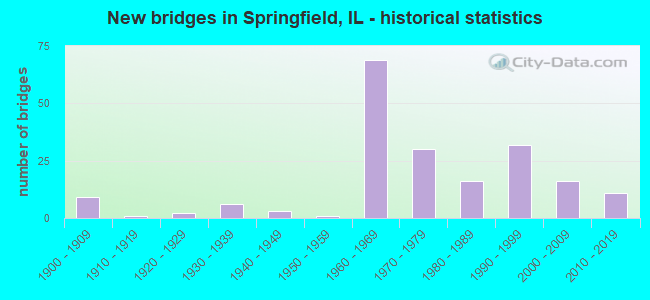
- New bridges - historical statistics
- 91900-1909
- 11910-1919
- 21920-1929
- 61930-1939
- 31940-1949
- 11950-1959
- 691960-1969
- 301970-1979
- 161980-1989
- 321990-1999
- 162000-2009
- 112010-2019

- Reconstructed bridges - Historical Statistics
- 11960-1969
- 21970-1979
- 21980-1989
- 111990-1999
- 72000-2009
- 32010-2019
- 22020-2022


- Bridge Condition - Deck
- 0.9%Excellent
- 24.1%Very good
- 41.1%Good
- 25.0%Satisfactory
- 5.4%Fair
- 3.6%Poor

- Bridge Condition - Superstructure
- 0.9%Excellent
- 25.9%Very good
- 43.8%Good
- 17.9%Satisfactory
- 7.1%Fair
- 4.5%Poor

- Bridge Condition - Substructure
- 31.3%Excellent
- 46.4%Very good
- 16.1%Good
- 4.5%Satisfactory
- 1.8%Fair
- 0.9%Poor

- Bridge Condition - Channel
- 40.7%Very good
- 33.3%Good
- 18.5%Satisfactory
- 7.4%Fair

- Bridge Condition - Culverts
- 8.7%Very good
- 52.2%Good
- 34.8%Satisfactory
- 4.3%Fair
Find on map >> Show street view
Structure Number: 849912, Location: 1.3M W VETERANS PKWY (Lat: 39.786689, Lng: -89.730789), Route carried "under" structure: Other road , Year Built: 1900, Structure Length: 0. m, Average Daily Traffic: 10,200 (year 2017), Truck Traffic: 14%, Features Intersected: OLD JACK RD/FAS 613, Facility Carried by Structure: SANGAMON VALLEY TR
Minimum Vertical Clearance: 5.08m (16.67ft), Kilometerpoint: 2.720, Lanes under structure: 2, Material/Design: Steel, Design/Construction: Stringer/Multi-beam, Length of Maximum Span: 14.6m (47.9ft)
Find on map >> Show street view
Structure Number: 849918, Location: 2BL E PEORIA RD (W) (Lat: 39.831075, Lng: -89.633853), Route carried "under" structure: State highway 29, Year Built: 1900, Structure Length: 0. m, Average Daily Traffic: 14,900 (year 2021), Truck Traffic: 5%, Features Intersected: SANGAMON AV /FAP 667, Facility Carried by Structure: ILLINOIS MIDLAND R
Minimum Vertical Clearance: 4.55m (14.93ft), Kilometerpoint: 73.320, Lanes under structure: 2, Material/Design: Steel continuous, Design/Construction: Stringer/Multi-beam, Length of Maximum Span: 24.4m (80.1ft)
Find on map >> Show street view
Structure Number: 849919, Location: 2BL E PEORIA RD (E) (Lat: 39.831081, Lng: -89.633683), Route carried "under" structure: State highway 29, Year Built: 1900, Structure Length: 0. m, Average Daily Traffic: 14,900 (year 2021), Truck Traffic: 5%, Features Intersected: SANGAMON AV /FAP 667, Facility Carried by Structure: UNION PACIFIC
Minimum Vertical Clearance: 4.70m (15.42ft), Kilometerpoint: 73.304, Lanes under structure: 2, Material/Design: Steel continuous, Design/Construction: Stringer/Multi-beam, Length of Maximum Span: 24.4m (80.1ft)
Find on map >> Show street view
Structure Number: 849923, Location: 1.8 M S CURRAN (Lat: 39.698078, Lng: -89.761372), Route carried "under" structure: County highway , Year Built: 1900, Structure Length: 0. m, Average Daily Traffic: 250 (year 2017), Truck Traffic: 16%, Features Intersected: TR 164, Facility Carried by Structure: C&NW RR
Minimum Vertical Clearance: 3.81m (12.50ft), Kilometerpoint: 4.055, Lanes under structure: 2, Material/Design: Steel, Design/Construction: Girder and Floorbeam System, Length of Maximum Span: 9.1m (29.9ft)
Find on map >> Show street view
Structure Number: 849925, Location: SW OF SPFLD (Lat: 39.742864, Lng: -89.719850), Route carried "under" structure: Other road , Year Built: 1900, Structure Length: 0. m, Average Daily Traffic: 3,450 (year 2012), Truck Traffic: 3%, Features Intersected: COCKRELL LN, Facility Carried by Structure: UP RR
Minimum Vertical Clearance: 3.71m (12.17ft), Kilometerpoint: 1.513, Lanes under structure: 2, Material/Design: Steel, Design/Construction: Girder and Floorbeam System, Length of Maximum Span: 8.8m (28.9ft)
Find on map >> Show street view
Structure Number: 849932, Location: .36M S ILES - SPFLD (Lat: 39.766244, Lng: -89.651233), Route carried "under" structure: Other road , Year Built: 1900, Structure Length: 0. m, Average Daily Traffic: 5,500 (year 2012), Truck Traffic: 16%, Features Intersected: 4TH STREET, Facility Carried by Structure: ILLINOIS CENTRAL R
Minimum Vertical Clearance: 4.55m (14.93ft), Kilometerpoint: 0.579, Lanes under structure: 2, Material/Design: Steel, Design/Construction: Girder and Floorbeam System, Length of Maximum Span: 23.2m (76.1ft)
Find on map >> Show street view
Structure Number: 849936, Location: .5M W IL4/VET. PKWY (Lat: 39.818328, Lng: -89.710467), Route carried "under" structure: State highway 97, Year Built: 1917, Structure Length: 0. m, Average Daily Traffic: 9,850 (year 2021), Truck Traffic: 4%, Features Intersected: IL 97/JEFFERSON ST, Facility Carried by Structure: SANGAMON VALLEY TR
Minimum Vertical Clearance: 4.65m (15.26ft), Kilometerpoint: 6.115, Lanes under structure: 2, Material/Design: Steel, Design/Construction: Girder and Floorbeam System, Length of Maximum Span: 14.3m (46.9ft)
Find on map >> Show street view
Structure Number: 849937, Location: .32MI-W-OF-MILAN DR. (Lat: 39.743150, Lng: -89.630364), Route carried "under" structure: Other road , Year Built: 1925, Structure Length: 0. m, Average Daily Traffic: 3,700 (year 2020), Truck Traffic: 2%, Features Intersected: FAU-8054 HAZEL DELL, Facility Carried by Structure: IC&G RR
Minimum Vertical Clearance: 3.43m (11.25ft), Kilometerpoint: 5.134, Lanes under structure: 2, Material/Design: Concrete, Design/Construction: Slab, Length of Maximum Span: 7.3m (24.0ft)
Find on map >> Show street view
Structure Number: 849939, Location: 1BL E 9TH ST - SPFLD (Lat: 39.794772, Lng: -89.642331), Route carried "under" structure: Other road , Year Built: 1988, Structure Length: 0. m, Average Daily Traffic: 8,200 (year 2017), Truck Traffic: 9%, Features Intersected: COOK ST. / FAU 7985, Facility Carried by Structure: NORFOLK SOUTHERN R
Minimum Vertical Clearance: 4.80m (15.75ft), Kilometerpoint: 0.097, Lanes under structure: 4, Material/Design: Steel, Design/Construction: Girder and Floorbeam System, Length of Maximum Span: 12.5m (41.0ft)
Find on map >> Show street view
Structure Number: 849942, Location: .06M W VETERANS PKWY (Lat: 39.845872, Lng: -89.632011), Route carried "under" structure: Business Interstate 55, Year Built: 1995, Structure Length: 0. m, Average Daily Traffic: 15,700 (year 2021), Truck Traffic: 9%, Features Intersected: PEORIA RD / BL 55, Facility Carried by Structure: ILLINOIS&MIDLAND R
Minimum Vertical Clearance: 5.23m (17.16ft), Kilometerpoint: 13.132, Lanes under structure: 4, Material/Design: Steel, Length of Maximum Span: 33.0m (108.3ft)
Find on map >> Show street view
Structure Number: 849943, Location: BETW 3RD ST & 4TH ST (Lat: 39.810886, Lng: -89.651042), Route carried "under" structure: Other road , Year Built: 1903, Structure Length: 0. m, Average Daily Traffic: 450 (year 2020), Truck Traffic: 6%, Features Intersected: DODGE ST. (FAU 7973), Facility Carried by Structure: UNION PACIFIC RR
Minimum Vertical Clearance: 3.43m (11.25ft), Kilometerpoint: 0.579, Lanes under structure: 2, Material/Design: Steel, Design/Construction: Girder and Floorbeam System, Length of Maximum Span: 9.2m (30.2ft)
Find on map >> Show street view
Structure Number: 849947, Location: E OF 9TH ST - SPFLD (Lat: 39.787206, Lng: -89.642642), Route carried "under" structure: Other road , Year Built: 1940, Structure Length: 0. m, Average Daily Traffic: 11,900 (year 2020), Truck Traffic: 4%, Features Intersected: SOUTH GRAND AVE, Facility Carried by Structure: NORFOLK SOUTHERN R
Minimum Vertical Clearance: 4.37m (14.34ft), Kilometerpoint: 3.911, Lanes under structure: 4, Material/Design: Steel, Design/Construction: Girder and Floorbeam System, Length of Maximum Span: 16.0m (52.5ft)