Bridge Statistics for Westminster, Colorado (CO)
Condition, Traffic, Stress, Structural Evaluation, Project Costs
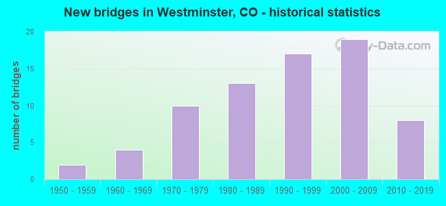
- New bridges - historical statistics
- 21950-1959
- 41960-1969
- 101970-1979
- 131980-1989
- 171990-1999
- 192000-2009
- 82010-2019

- Reconstructed bridges - Historical Statistics
- 11960-1969
- 01970-1979
- 21980-1989
- 21990-1999
- 22000-2009


- Bridge Condition - Deck
- 16.7%Very good
- 44.4%Good
- 38.9%Satisfactory

- Bridge Condition - Superstructure
- 19.4%Very good
- 38.9%Good
- 36.1%Satisfactory
- 5.6%Fair

- Bridge Condition - Substructure
- 16.7%Very good
- 44.4%Good
- 38.9%Satisfactory

- Bridge Condition - Channel
- 50.0%Very good
- 35.4%Good
- 14.6%Satisfactory

- Bridge Condition - Culverts
- 3.7%Very good
- 55.6%Good
- 40.7%Satisfactory
Find on map >> Show street view
Structure Number: WST15-10-J, Location: 0.5 MI S OF CHURCH RANCH (Lat: 39.882922, Lng: -105.067436), Route carried "on" structure: City street , Year Built: 2002, Status: Open, Structure Length: 7.03m (23.06ft), Average Daily Traffic: 4,300 (year 2021), Truck Traffic: 2%, Average Future Daily Traffic: 4,945 (year 2041), Design Load: HS 25 or greater, Features Intersected: BIG DRY CREEK, Facility Carried by Structure: WESTMINSTER BLVD
Minimum Vertical Clearance: 30+ m (98+ ft), Kilometerpoint: 2.242, Lanes on structure: 2, Owner: City or Municipal Highway Agency, Approaching Roadway Width: 8.5m (27.9ft), Material/Design: Prestressed concrete continuous, Design/Construction: Stringer/Multi-beam, Number Of Spans In Main Unit: 2, Length of Maximum Span: 33.8m (110.9ft), Curb or Sidewalk Widths: Left: 0.0m, Right: 3.3m (10.8ft), Curb-To-Curb Width: 19.8m (65.0ft), Out-to-Out Width: 24.2m (79.4ft)
Condition: Deck: Good, Superstructure: Good, Substructure: Good, Channel: Satisfactory, Operating Rating: 74.7 metric tons, Method Used To Determine Operating Rating: Load Factor (LF), Inventory Rating: 44.7 metric tons, Method Used To Determine Inventory Rating: Load Factor (LF), Structural Evaluation: Better than present minimum criteria, Deck Geometry: Superior to present desirable criteria, Waterway Adequacy: Equal to present desirable criteria, Approach Roadway Alignment: Equal to present desirable criteria, Designated Inspection Frequency: Every 24 months, Inspection Date: March 2021, Deck Structure Type: Concrete Precast Panels, Wearing Surface/Protective System: Wearing Surface: Bituminous, Membrane: Built-up, Deck Protection: Epoxy Coated Reinforcing
Find on map >> Show street view
Structure Number: WST16-11-J, Location: .3 MI SW US 36 & 104T (Lat: 39.885083, Lng: -105.075169), Route carried "on" structure: City street , Year Built: 1991, Year Reconstructed: 2006, Status: Open, Structure Length: 1.33m (4.36ft), Average Daily Traffic: 28,002 (year 2021), Truck Traffic: 2%, Average Future Daily Traffic: 32,203 (year 2041), Design Load: HS 20, Features Intersected: WALNUT CREEK, Facility Carried by Structure: CHURCH RANCH BLVD
Minimum Vertical Clearance: 30+ m (98+ ft), Kilometerpoint: 2.268, Lanes on structure: 10, Owner: City or Municipal Highway Agency, Approaching Roadway Width: 22.3m (73.2ft), Skew: 30 degrees, Material/Design: Concrete, Design/Construction: Culvert, Number Of Spans In Main Unit: 3, Length of Maximum Span: 4.3m (14.1ft), Curb or Sidewalk Widths: Left: 5.2m (17.1ft), Right: 4.4m (14.4ft), Curb-To-Curb Width: 44.9m (147.3ft), Out-to-Out Width: 46.6m (152.9ft)
Condition: Channel: Very good, Culverts: Satisfactory, Operating Rating: 66.3 metric tons, Method Used To Determine Operating Rating: Load Factor (LF), Inventory Rating: 39.7 metric tons, Method Used To Determine Inventory Rating: Load Factor (LF), Structural Evaluation: Equal to present minimum criteria, Deck Geometry: Superior to present desirable criteria, Waterway Adequacy: Equal to present desirable criteria, Approach Roadway Alignment: Equal to present desirable criteria, Designated Inspection Frequency: Every 48 months, Inspection Date: Febuary 2019
Find on map >> Show street view
Structure Number: WST16-12-J, Location: .2 MI SE OF CHURCH RANCH (Lat: 39.878356, Lng: -105.076181), Route carried "on" structure: City street , Year Built: 1996, Status: Open, Structure Length: 1.33m (4.36ft), Average Daily Traffic: 4,806 (year 2021), Truck Traffic: 4%, Average Future Daily Traffic: 5,526 (year 2041), Design Load: HS 20, Features Intersected: BIG DRY CREEK, Facility Carried by Structure: WESTCLIFF PKWY
Minimum Vertical Clearance: 30+ m (98+ ft), Kilometerpoint: 0.278, Lanes on structure: 4, Owner: City or Municipal Highway Agency, Approaching Roadway Width: 14.6m (47.9ft), Material/Design: Concrete, Design/Construction: Culvert, Number Of Spans In Main Unit: 3, Length of Maximum Span: 4.3m (14.1ft), Curb or Sidewalk Widths: Left: 2.0m (6.6ft), Right: 2.0m (6.6ft), Curb-To-Curb Width: 18.6m (61.0ft), Out-to-Out Width: 19.3m (63.3ft)
Condition: Channel: Good, Culverts: Good, Operating Rating: 82.2 metric tons, Method Used To Determine Operating Rating: Load Factor (LF), Inventory Rating: 49.3 metric tons, Method Used To Determine Inventory Rating: Load Factor (LF), Structural Evaluation: Better than present minimum criteria, Deck Geometry: Equal to present minimum criteria, Waterway Adequacy: Equal to present desirable criteria, Approach Roadway Alignment: Equal to present desirable criteria, Designated Inspection Frequency: Every 24 months, Inspection Date: Febuary 2021
Find on map >> Show street view
Structure Number: WST17-10-H, Location: .7 MI W OF SHERIDAN BLVD (Lat: 39.887139, Lng: -105.065169), Route carried "on" structure: City street , Year Built: 1991, Status: Open, Structure Length: 1.97m (6.46ft), Average Daily Traffic: 25,844 (year 2021), Truck Traffic: 2%, Average Future Daily Traffic: 29,721 (year 2041), Design Load: HS 20, Features Intersected: BIG DRY CREEK, Facility Carried by Structure: 104TH AVE
Minimum Vertical Clearance: 30+ m (98+ ft), Kilometerpoint: 0.629, Lanes on structure: 4, Base Highway Network: Yes, Owner: City or Municipal Highway Agency, Approaching Roadway Width: 16.5m (54.1ft), Skew: 30 degrees, Material/Design: Concrete, Design/Construction: Culvert, Number Of Spans In Main Unit: 5, Length of Maximum Span: 3.9m (12.8ft), Curb or Sidewalk Widths: Left: 1.6m (5.2ft), Right: 2.5m (8.2ft), Curb-To-Curb Width: 21.9m (71.9ft), Out-to-Out Width: 26.7m (87.6ft)
Condition: Channel: Good, Culverts: Good, Operating Rating: 73.4 metric tons, Method Used To Determine Operating Rating: Load Factor (LF), Inventory Rating: 44.0 metric tons, Method Used To Determine Inventory Rating: Load Factor (LF), Structural Evaluation: Better than present minimum criteria, Deck Geometry: Superior to present desirable criteria, Waterway Adequacy: Equal to present desirable criteria, Approach Roadway Alignment: Equal to present desirable criteria, Designated Inspection Frequency: Every 48 months, Inspection Date: Febuary 2019
Find on map >> Show street view
Structure Number: WST18-09-H, Location: .5 MI W OF SHERIDAN BLVD (Lat: 39.885444, Lng: -105.061817), Route carried "on" structure: City street , Year Built: 1991, Status: Open, Structure Length: 1.36m (4.46ft), Average Daily Traffic: 25,211 (year 2021), Truck Traffic: 2%, Average Future Daily Traffic: 28,993 (year 2041), Design Load: HS 20, Features Intersected: S. BRANCH HYLAND CREEK, Facility Carried by Structure: 104TH AVE
Minimum Vertical Clearance: 30+ m (98+ ft), Kilometerpoint: 0.983, Lanes on structure: 4, Base Highway Network: Yes, Owner: City or Municipal Highway Agency, Approaching Roadway Width: 16.5m (54.1ft), Skew: 33 degrees, Material/Design: Concrete, Design/Construction: Culvert, Number Of Spans In Main Unit: 3, Length of Maximum Span: 4.8m (15.7ft), Curb or Sidewalk Widths: Left: 1.6m (5.2ft), Right: 2.7m (8.9ft), Curb-To-Curb Width: 20.8m (68.2ft), Out-to-Out Width: 26.9m (88.3ft)
Condition: Channel: Good, Culverts: Good, Operating Rating: 64.4 metric tons, Method Used To Determine Operating Rating: Load Factor (LF), Inventory Rating: 38.6 metric tons, Method Used To Determine Inventory Rating: Load Factor (LF), Structural Evaluation: Better than present minimum criteria, Deck Geometry: Superior to present desirable criteria, Waterway Adequacy: Equal to present desirable criteria, Approach Roadway Alignment: Equal to present desirable criteria, Designated Inspection Frequency: Every 48 months, Inspection Date: Febuary 2019
Find on map >> Show street view
Structure Number: WST18-12-H, Location: 104TH AVENUE E WADSWORTH (Lat: 39.885139, Lng: -105.092308), Route carried "on" structure: City street , Year Built: 1978, Status: Open, Structure Length: 0.62m (2.03ft), Average Daily Traffic: 995 (year 2021), Truck Traffic: 2%, Average Future Daily Traffic: 1,144 (year 2041), Features Intersected: TRIB TO BIG DRY CREEK, Facility Carried by Structure: DOVER STREET
Minimum Vertical Clearance: 30+ m (98+ ft), Kilometerpoint: 0.506, Lanes on structure: 2, Owner: City or Municipal Highway Agency, Approaching Roadway Width: 13.4m (44.0ft), Skew: 1 degrees, Material/Design: Concrete, Design/Construction: Culvert, Number Of Spans In Main Unit: 2, Length of Maximum Span: 2.9m (9.5ft), Curb or Sidewalk Widths: Left: 1.2m (3.9ft), Right: 1.2m (3.9ft), Out-to-Out Width: 24.4m (80.1ft)
Condition: Channel: Good, Culverts: Satisfactory, Operating Rating: 36.3 metric tons, Method Used To Determine Operating Rating: Field evaluation and documented engineering judgment, Inventory Rating: 32.7 metric tons, Method Used To Determine Inventory Rating: Field evaluation and documented engineering judgment, Structural Evaluation: Equal to present minimum criteria, Waterway Adequacy: Equal to present desirable criteria, Approach Roadway Alignment: Equal to present minimum criteria, Designated Inspection Frequency: Every 24 months, Inspection Date: Febuary 2021
Find on map >> Show street view
Structure Number: WST18-14-J, Location: .5 MI E OF WADSWORTH BLVD (Lat: 39.881208, Lng: -105.087342), Route carried "on" structure: City street , Year Built: 1997, Status: Open, Structure Length: 6.29m (20.64ft), Average Daily Traffic: 117 (year 2021), Truck Traffic: 4%, Average Future Daily Traffic: 134 (year 2041), Design Load: HS 20, Features Intersected: CHURCH RANCH BOULEVARD, Facility Carried by Structure: ZEPHYR STREET
Minimum Vertical Clearance: 30+ m (98+ ft), Kilometerpoint: 0.845, Lanes on structure: 2, Lanes under structure: 4, Owner: City or Municipal Highway Agency, Approaching Roadway Width: 7.6m (24.9ft), Skew: 2 degrees, Material/Design: Steel continuous, Design/Construction: Stringer/Multi-beam, Number Of Spans In Main Unit: 2, Length of Maximum Span: 30.8m (101.0ft), Curb or Sidewalk Widths: Left: 1.4m (4.6ft), Right: 1.4m (4.6ft), Curb-To-Curb Width: 8.5m (27.9ft), Out-to-Out Width: 12.0m (39.4ft)
Condition: Deck: Satisfactory, Superstructure: Good, Substructure: Satisfactory, Operating Rating: 71.7 metric tons, Method Used To Determine Operating Rating: Load Factor (LF), Inventory Rating: 43.0 metric tons, Method Used To Determine Inventory Rating: Load Factor (LF), Structural Evaluation: Equal to present minimum criteria, Deck Geometry: Equal to present minimum criteria, Underclear: High priority of corrective action, Approach Roadway Alignment: Equal to present desirable criteria, Designated Inspection Frequency: Every 24 months, Inspection Date: March 2021, Deck Structure Type: Concrete Cast-file-Place, Wearing Surface/Protective System: Wearing Surface: Monolithic Concrete, Deck Protection: Epoxy Coated Reinforcing
Find on map >> Show street view
Structure Number: WST19-09-E, Location: JUST S OF W 120TH AVE (Lat: 39.913908, Lng: -105.052561), Route carried "on" structure: City street , Year Built: 1964, Year Reconstructed: 1995, Status: Open, Structure Length: 0.63m (2.07ft), Average Daily Traffic: 16,503 (year 2021), Truck Traffic: 2%, Average Future Daily Traffic: 21,453 (year 2041), Features Intersected: LOCAL DRAINAGE, Facility Carried by Structure: SHERIDAN BLVD
Minimum Vertical Clearance: 30+ m (98+ ft), Kilometerpoint: 5.975, Lanes on structure: 8, Owner: City or Municipal Highway Agency, Approaching Roadway Width: 21.9m (71.9ft), Skew: 20 degrees, Material/Design: Concrete, Design/Construction: Culvert, Number Of Spans In Main Unit: 2, Length of Maximum Span: 3.0m (9.8ft), Curb or Sidewalk Widths: Left: 3.8m (12.5ft), Right: 0.0m, Curb-To-Curb Width: 42.7m (140.1ft), Out-to-Out Width: 58.5m (191.9ft)
Condition: Channel: Satisfactory, Culverts: Satisfactory, Operating Rating: 39.7 metric tons, Method Used To Determine Operating Rating: Load Factor (LF), Inventory Rating: 23.8 metric tons, Method Used To Determine Inventory Rating: Load Factor (LF), Structural Evaluation: Somewhat better than minimum adequacy, Deck Geometry: Superior to present desirable criteria, Waterway Adequacy: Equal to present desirable criteria, Approach Roadway Alignment: Equal to present desirable criteria, Designated Inspection Frequency: Every 24 months, Inspection Date: December 2021
Find on map >> Show street view
Structure Number: WST19-10-E, Location: .1 MI E SHERIDAN S 120TH (Lat: 39.913889, Lng: -105.051111), Route carried "on" structure: Ramp City street , Year Built: 1997, Status: Open, Structure Length: 1.26m (4.13ft), Average Daily Traffic: 1,450 (year 2021), Truck Traffic: 4%, Average Future Daily Traffic: 1,885 (year 2041), Design Load: HS 25 or greater, Features Intersected: LOCAL DRAINAGE, Facility Carried by Structure: W MALL ENTRANCE
Minimum Vertical Clearance: 30+ m (98+ ft), Kilometerpoint: 21.543, Lanes on structure: 1, Owner: City or Municipal Highway Agency, Approaching Roadway Width: 6.6m (21.7ft), Material/Design: Concrete, Design/Construction: Frame, Number Of Spans In Main Unit: 2, Length of Maximum Span: 5.8m (19.0ft), Curb or Sidewalk Widths: Left: 2.2m (7.2ft), Right: 1.3m (4.3ft), Curb-To-Curb Width: 6.6m (21.7ft), Out-to-Out Width: 10.9m (35.8ft)
Condition: Deck: Satisfactory, Superstructure: Satisfactory, Substructure: Good, Channel: Very good, Operating Rating: 58.2 metric tons, Method Used To Determine Operating Rating: Load Factor (LF), Inventory Rating: 34.9 metric tons, Method Used To Determine Inventory Rating: Load Factor (LF), Structural Evaluation: Equal to present minimum criteria, Deck Geometry: Somewhat better than minimum adequacy, Waterway Adequacy: Equal to present desirable criteria, Approach Roadway Alignment: Equal to present desirable criteria, Designated Inspection Frequency: Every 24 months, Inspection Date: December 2021, Deck Structure Type: Other, Wearing Surface/Protective System: Wearing Surface: Bituminous, Deck Protection: Epoxy Coated Reinforcing
Find on map >> Show street view
Structure Number: WST19-11-E, Location: .2 MI E SHERIDAN S 120TH (Lat: 39.913864, Lng: -105.049564), Route carried "on" structure: City street , Year Built: 1997, Status: Open, Structure Length: 1.26m (4.13ft), Average Daily Traffic: 1,245 (year 2021), Truck Traffic: 4%, Average Future Daily Traffic: 1,619 (year 2041), Design Load: HS 25 or greater, Features Intersected: LOCAL DRAINAGE, Facility Carried by Structure: E MALL ENTRANCE
Minimum Vertical Clearance: 30+ m (98+ ft), Kilometerpoint: 21.411, Lanes on structure: 2, Owner: City or Municipal Highway Agency, Approaching Roadway Width: 13.4m (44.0ft), Material/Design: Concrete, Design/Construction: Frame, Number Of Spans In Main Unit: 2, Length of Maximum Span: 5.8m (19.0ft), Curb or Sidewalk Widths: Left: 2.1m (6.9ft), Right: 2.2m (7.2ft), Curb-To-Curb Width: 13.4m (44.0ft), Out-to-Out Width: 18.5m (60.7ft)
Condition: Deck: Satisfactory, Superstructure: Satisfactory, Substructure: Good, Channel: Very good, Operating Rating: 56.2 metric tons, Method Used To Determine Operating Rating: Load Factor (LF), Inventory Rating: 33.7 metric tons, Method Used To Determine Inventory Rating: Load Factor (LF), Structural Evaluation: Equal to present minimum criteria, Deck Geometry: Equal to present desirable criteria, Waterway Adequacy: Equal to present desirable criteria, Approach Roadway Alignment: Equal to present desirable criteria, Designated Inspection Frequency: Every 24 months, Inspection Date: December 2021, Deck Structure Type: Other, Wearing Surface/Protective System: Wearing Surface: Bituminous, Deck Protection: Epoxy Coated Reinforcing
Find on map >> Show street view
Structure Number: WST19-12-E, Location: .3 MI E SHERIDAN S 120TH (Lat: 39.913728, Lng: -105.046275), Route carried "on" structure: City street , Year Built: 1997, Status: Open, Structure Length: 0.97m (3.18ft), Average Daily Traffic: 7,063 (year 2021), Average Future Daily Traffic: 9,183 (year 2041), Design Load: HS 25 or greater, Features Intersected: LOCAL DRAINAGE, Facility Carried by Structure: VRAIN STREET
Minimum Vertical Clearance: 30+ m (98+ ft), Kilometerpoint: 0.000, Lanes on structure: 4, Owner: City or Municipal Highway Agency, Approaching Roadway Width: 14.8m (48.6ft), Material/Design: Concrete, Design/Construction: Frame, Number Of Spans In Main Unit: 1, Length of Maximum Span: 9.1m (29.9ft), Curb or Sidewalk Widths: Left: 0.7m (2.3ft), Right: 2.4m (7.9ft), Curb-To-Curb Width: 14.8m (48.6ft), Out-to-Out Width: 18.5m (60.7ft)
Condition: Deck: Satisfactory, Superstructure: Satisfactory, Substructure: Good, Channel: Very good, Operating Rating: 83.7 metric tons, Method Used To Determine Operating Rating: Load Factor (LF), Inventory Rating: 50.2 metric tons, Method Used To Determine Inventory Rating: Load Factor (LF), Structural Evaluation: Equal to present minimum criteria, Deck Geometry: High priority of replacement, Waterway Adequacy: Equal to present desirable criteria, Approach Roadway Alignment: Equal to present desirable criteria, Designated Inspection Frequency: Every 24 months, Inspection Date: December 2021, Deck Structure Type: Other, Wearing Surface/Protective System: Wearing Surface: Bituminous, Deck Protection: Epoxy Coated Reinforcing
Find on map >> Show street view
Structure Number: WST19-13-E, Location: 0.1 MI W OF PERRY ST (Lat: 39.913769, Lng: -105.041664), Route carried "on" structure: City street , Year Built: 2003, Status: Open, Structure Length: 1.10m (3.61ft), Average Daily Traffic: 2,603 (year 2021), Truck Traffic: 2%, Average Future Daily Traffic: 3,383 (year 2041), Features Intersected: LOCAL DRAINAGE, Facility Carried by Structure: BRADBURN BOULEVARD
Minimum Vertical Clearance: 30+ m (98+ ft), Kilometerpoint: 0.513, Lanes on structure: 3, Owner: City or Municipal Highway Agency, Approaching Roadway Width: 7.6m (24.9ft), Skew: 20 degrees, Material/Design: Concrete, Design/Construction: Culvert, Number Of Spans In Main Unit: 1, Length of Maximum Span: 11.0m (36.1ft), Curb or Sidewalk Widths: Left: 2.7m (8.9ft), Right: 2.7m (8.9ft), Curb-To-Curb Width: 15.2m (49.9ft), Out-to-Out Width: 21.6m (70.9ft)
Condition: Channel: Very good, Culverts: Good, Operating Rating: 36.3 metric tons, Method Used To Determine Operating Rating: Field evaluation and documented engineering judgment, Inventory Rating: 32.7 metric tons, Method Used To Determine Inventory Rating: Field evaluation and documented engineering judgment, Structural Evaluation: Better than present minimum criteria, Deck Geometry: Equal to present minimum criteria, Waterway Adequacy: Equal to present desirable criteria, Approach Roadway Alignment: Equal to present desirable criteria, Designated Inspection Frequency: Every 24 months, Inspection Date: December 2021
Find on map >> Show street view
Structure Number: WST20-05-C, Location: .6 MI N OF 120TH AVE (Lat: 39.923100, Lng: -105.014381), Route carried "on" structure: City street , Year Built: 2002, Status: Open, Structure Length: 5.46m (17.91ft), Average Daily Traffic: 14,581 (year 2021), Truck Traffic: 2%, Average Future Daily Traffic: 18,955 (year 2041), Design Load: HS 25 or greater, Features Intersected: BIG DRY CREEK, Facility Carried by Structure: FEDERAL PARKWAY
Minimum Vertical Clearance: 30+ m (98+ ft), Kilometerpoint: 1.602, Lanes on structure: 2, Owner: City or Municipal Highway Agency, Approaching Roadway Width: 8.5m (27.9ft), Material/Design: Prestressed concrete continuous, Design/Construction: Stringer/Multi-beam, Number Of Spans In Main Unit: 2, Length of Maximum Span: 25.9m (85.0ft), Curb or Sidewalk Widths: Left: 2.4m (7.9ft), Right: 0.0m, Curb-To-Curb Width: 8.5m (27.9ft), Out-to-Out Width: 12.2m (40.0ft)
Condition: Deck: Good, Superstructure: Good, Substructure: Good, Channel: Good, Operating Rating: 80.1 metric tons, Method Used To Determine Operating Rating: Load Factor (LF), Inventory Rating: 48.0 metric tons, Method Used To Determine Inventory Rating: Load Factor (LF), Structural Evaluation: Better than present minimum criteria, Deck Geometry: High priority of replacement, Waterway Adequacy: Equal to present desirable criteria, Approach Roadway Alignment: Equal to present desirable criteria, Length Of Structure Improvement: 6.49m (21.29ft), Designated Inspection Frequency: Every 24 months, Inspection Date: December 2021, Deck Structure Type: Concrete Precast Panels, Wearing Surface/Protective System: Wearing Surface: Bituminous, Deck Protection: Epoxy Coated Reinforcing
Find on map >> Show street view
Structure Number: WST20-05-D, Location: N OF 120TH AVE ON FEDERAL (Lat: 39.915286, Lng: -105.025050), Route carried "on" structure: City street , Year Built: 2002, Status: Open, Structure Length: 0.76m (2.49ft), Average Daily Traffic: 10,952 (year 2021), Truck Traffic: 3%, Average Future Daily Traffic: 14,238 (year 2041), Design Load: HS 25 or greater, Features Intersected: RANCH CREEK, Facility Carried by Structure: FEDERAL BLVD
Minimum Vertical Clearance: 30+ m (98+ ft), Kilometerpoint: 0.121, Lanes on structure: 5, Owner: City or Municipal Highway Agency, Approaching Roadway Width: 18.3m (60.0ft), Material/Design: Concrete, Design/Construction: Culvert, Number Of Spans In Main Unit: 2, Length of Maximum Span: 3.7m (12.1ft), Out-to-Out Width: 42.5m (139.4ft)
Condition: Channel: Good, Culverts: Good, Structural Evaluation: Better than present minimum criteria, Waterway Adequacy: Equal to present desirable criteria, Approach Roadway Alignment: Equal to present desirable criteria, Designated Inspection Frequency: Every 24 months, Inspection Date: December 2021
Find on map >> Show street view
Structure Number: WST20-06-B, Location: 0.6 MI W OF HURON ST. (Lat: 39.928556, Lng: -105.010325), Route carried "on" structure: City street , Year Built: 1978, Status: Open, Structure Length: 3.70m (12.14ft), Average Daily Traffic: 17,866 (year 2021), Truck Traffic: 4%, Average Future Daily Traffic: 23,225 (year 2041), Features Intersected: BIG DRY CREEK, Facility Carried by Structure: 128TH AVENUE
Minimum Vertical Clearance: 30+ m (98+ ft), Kilometerpoint: 0.211, Lanes on structure: 2, Owner: City or Municipal Highway Agency, Approaching Roadway Width: 7.9m (25.9ft), Material/Design: Prestressed concrete continuous, Design/Construction: Tee Beam, Number Of Spans In Main Unit: 2, Length of Maximum Span: 17.7m (58.1ft), Curb or Sidewalk Widths: Left: 1.6m (5.2ft), Right: 0.0m, Curb-To-Curb Width: 11.0m (36.1ft), Out-to-Out Width: 13.2m (43.3ft)
Condition: Deck: Good, Superstructure: Satisfactory, Substructure: Good, Channel: Good, Operating Rating: 45.3 metric tons, Method Used To Determine Operating Rating: Load Factor (LF), Inventory Rating: 18.0 metric tons, Method Used To Determine Inventory Rating: Load Factor (LF), Structural Evaluation: Meets minimum limits, Deck Geometry: Meets minimum limits, Waterway Adequacy: Equal to present desirable criteria, Approach Roadway Alignment: Equal to present desirable criteria, Designated Inspection Frequency: Every 24 months, Inspection Date: December 2021, Deck Structure Type: Concrete Cast-file-Place, Wearing Surface/Protective System: Wearing Surface: Bituminous, Membrane: Built-up
Find on map >> Show street view
Structure Number: WST21-03-A, Location: .2 MI N OF 128TH AVENUE (Lat: 39.933842, Lng: -104.997017), Route carried "on" structure: City street , Year Built: 2004, Status: Open, Structure Length: 6.49m (21.29ft), Average Daily Traffic: 12,488 (year 2021), Truck Traffic: 3%, Average Future Daily Traffic: 16,234 (year 2041), Design Load: HS 25 or greater, Features Intersected: BIG DRY CREEK, Facility Carried by Structure: HURON STREET
Minimum Vertical Clearance: 30+ m (98+ ft), Kilometerpoint: 2.511, Lanes on structure: 4, Owner: City or Municipal Highway Agency, Approaching Roadway Width: 15.5m (50.9ft), Skew: 30 degrees, Material/Design: Prestressed concrete continuous, Design/Construction: Stringer/Multi-beam, Number Of Spans In Main Unit: 3, Length of Maximum Span: 20.5m (67.3ft), Curb or Sidewalk Widths: Left: 3.5m (11.5ft), Right: 3.5m (11.5ft), Curb-To-Curb Width: 19.8m (65.0ft), Out-to-Out Width: 27.7m (90.9ft)
Condition: Deck: Good, Superstructure: Very good, Substructure: Good, Channel: Very good, Operating Rating: 86.9 metric tons, Method Used To Determine Operating Rating: Load Factor (LF), Inventory Rating: 45.2 metric tons, Method Used To Determine Inventory Rating: Load Factor (LF), Structural Evaluation: Better than present minimum criteria, Deck Geometry: Better than present minimum criteria, Waterway Adequacy: Equal to present desirable criteria, Approach Roadway Alignment: Equal to present desirable criteria, Designated Inspection Frequency: Every 24 months, Inspection Date: December 2021, Deck Structure Type: Concrete Cast-file-Place, Wearing Surface/Protective System: Wearing Surface: Bituminous, Membrane: Built-up, Deck Protection: Epoxy Coated Reinforcing
Find on map >> Show street view
Structure Number: WST21-04-A, Location: 1 BLK S OF 132ND AVE (Lat: 39.936878, Lng: -104.996794), Route carried "on" structure: City street , Year Built: 1978, Year Reconstructed: 2004, Status: Open, Structure Length: 1.30m (4.27ft), Average Daily Traffic: 11,054 (year 2021), Truck Traffic: 9%, Average Future Daily Traffic: 14,371 (year 2041), Features Intersected: BULL CANAL, Facility Carried by Structure: HURON STREET
Minimum Vertical Clearance: 30+ m (98+ ft), Kilometerpoint: 2.848, Lanes on structure: 4, Owner: City or Municipal Highway Agency, Approaching Roadway Width: 15.2m (49.9ft), Skew: 34 degrees, Material/Design: Prestressed concrete, Design/Construction: Tee Beam, Number Of Spans In Main Unit: 1, Length of Maximum Span: 11.3m (37.1ft), Curb or Sidewalk Widths: Left: 4.5m (14.8ft), Right: 4.2m (13.8ft), Curb-To-Curb Width: 15.2m (49.9ft), Out-to-Out Width: 29.5m (96.8ft)
Condition: Deck: Good, Superstructure: Satisfactory, Substructure: Good, Channel: Very good, Operating Rating: 36.3 metric tons, Method Used To Determine Operating Rating: Field evaluation and documented engineering judgment, Inventory Rating: 28.3 metric tons, Method Used To Determine Inventory Rating: Load Factor (LF), Structural Evaluation: Equal to present minimum criteria, Deck Geometry: High priority of corrective action, Waterway Adequacy: Equal to present desirable criteria, Approach Roadway Alignment: Equal to present desirable criteria, Length Of Structure Improvement: 1.98m (6.50ft), Designated Inspection Frequency: Every 24 months, Inspection Date: December 2021, Deck Structure Type: Concrete Cast-file-Place, Wearing Surface/Protective System: Wearing Surface: Bituminous
Find on map >> Show street view
Structure Number: WST22-08-F, Location: 0.25 MI E OF SHERIDAN BLV (Lat: 39.906997, Lng: -105.048392), Route carried "on" structure: City street , Year Built: 2006, Status: Open, Structure Length: 0.67m (2.20ft), Average Daily Traffic: 1,803 (year 2021), Truck Traffic: 1%, Average Future Daily Traffic: 2,343 (year 2041), Features Intersected: COZY CORNER TRIBUTARY #5, Facility Carried by Structure: WOLFF ST
Minimum Vertical Clearance: 30+ m (98+ ft), Kilometerpoint: 0.000, Lanes on structure: 2, Owner: City or Municipal Highway Agency, Approaching Roadway Width: 10.4m (34.1ft), Skew: 1 degrees, Material/Design: Concrete, Design/Construction: Culvert, Number Of Spans In Main Unit: 2, Length of Maximum Span: 3.2m (10.5ft), Curb or Sidewalk Widths: Left: 2.4m (7.9ft), Right: 3.4m (11.2ft), Curb-To-Curb Width: 10.4m (34.1ft), Out-to-Out Width: 26.2m (86.0ft)
Condition: Channel: Very good, Culverts: Good, Operating Rating: 36.3 metric tons, Method Used To Determine Operating Rating: Field evaluation and documented engineering judgment, Inventory Rating: 32.7 metric tons, Method Used To Determine Inventory Rating: Field evaluation and documented engineering judgment, Structural Evaluation: Better than present minimum criteria, Deck Geometry: Equal to present minimum criteria, Waterway Adequacy: Equal to present desirable criteria, Approach Roadway Alignment: Equal to present desirable criteria, Designated Inspection Frequency: Every 24 months, Inspection Date: December 2021
Find on map >> Show street view
Structure Number: WST22-15-L, Location: 0.05 MI N OF 98TH AVE (Lat: 39.874800, Lng: -105.081456), Route carried "on" structure: City street , Year Built: 2009, Status: Open, Structure Length: 3.14m (10.30ft), Average Daily Traffic: 8,654 (year 2021), Truck Traffic: 4%, Average Future Daily Traffic: 9,953 (year 2041), Design Load: HL 93, Features Intersected: BIG DRY CREEK, Facility Carried by Structure: WADSWORTH BLVD
Minimum Vertical Clearance: 30+ m (98+ ft), Kilometerpoint: 0.168, Lanes on structure: 4, Owner: City or Municipal Highway Agency, Approaching Roadway Width: 19.5m (64.0ft), Skew: 20 degrees, Material/Design: Prestressed concrete, Design/Construction: Stringer/Multi-beam, Number Of Spans In Main Unit: 1, Number Of Approach Spans: 1, Length of Maximum Span: 25.3m (83.0ft), Curb or Sidewalk Widths: Left: 3.2m (10.5ft), Right: 3.2m (10.5ft), Curb-To-Curb Width: 19.5m (64.0ft), Out-to-Out Width: 26.5m (86.9ft)
Condition: Deck: Good, Superstructure: Satisfactory, Substructure: Satisfactory, Channel: Good, Operating Rating: 59.4 metric tons, Method Used To Determine Operating Rating: Load Factor (LF), Inventory Rating: 30.3 metric tons, Method Used To Determine Inventory Rating: Load Factor (LF), Structural Evaluation: Equal to present minimum criteria, Deck Geometry: Better than present minimum criteria, Waterway Adequacy: Equal to present desirable criteria, Approach Roadway Alignment: Equal to present desirable criteria, Designated Inspection Frequency: Every 24 months, Inspection Date: March 2021, Deck Structure Type: Concrete Precast Panels, Wearing Surface/Protective System: Wearing Surface: Bituminous, Membrane: Built-up, Deck Protection: Epoxy Coated Reinforcing
Find on map >> Show street view
Structure Number: WST23-02-A, Location: JUST N OF 134TH AVE (Lat: 39.940581, Lng: -104.996758), Route carried "on" structure: City street , Year Built: 2006, Status: Open, Structure Length: 0.61m (2.00ft), Average Daily Traffic: 11,623 (year 2021), Truck Traffic: 3%, Average Future Daily Traffic: 15,110 (year 2041), Features Intersected: QUAIL CREEK, Facility Carried by Structure: HURON ST
Minimum Vertical Clearance: 30+ m (98+ ft), Kilometerpoint: 3.257, Lanes on structure: 5, Owner: City or Municipal Highway Agency, Approaching Roadway Width: 18.5m (60.7ft), Skew: 10 degrees, Material/Design: Concrete, Design/Construction: Culvert, Number Of Spans In Main Unit: 1, Length of Maximum Span: 6.1m (20.0ft), Curb or Sidewalk Widths: Left: 2.6m (8.5ft), Right: 2.5m (8.2ft), Curb-To-Curb Width: 18.5m (60.7ft), Out-to-Out Width: 38.4m (126.0ft)
Condition: Channel: Very good, Culverts: Good, Operating Rating: 36.3 metric tons, Method Used To Determine Operating Rating: Field evaluation and documented engineering judgment, Inventory Rating: 32.7 metric tons, Method Used To Determine Inventory Rating: Field evaluation and documented engineering judgment, Structural Evaluation: Better than present minimum criteria, Deck Geometry: High priority of corrective action, Waterway Adequacy: Equal to present desirable criteria, Approach Roadway Alignment: Equal to present desirable criteria, Designated Inspection Frequency: Every 24 months, Inspection Date: December 2021
Find on map >> Show street view
Structure Number: WST24-02-W, Location: 0.25 MI S OF 152ND AVE (Lat: 39.968342, Lng: -104.997022), Route carried "on" structure: City street , Year Built: 2006, Status: Open, Structure Length: 0.67m (2.20ft), Average Daily Traffic: 8,232 (year 2021), Truck Traffic: 3%, Average Future Daily Traffic: 10,702 (year 2041), Features Intersected: SHAY DITCH, Facility Carried by Structure: HURON ST
Minimum Vertical Clearance: 30+ m (98+ ft), Kilometerpoint: 0.379, Lanes on structure: 3, Owner: City or Municipal Highway Agency, Approaching Roadway Width: 7.9m (25.9ft), Skew: 30 degrees, Material/Design: Concrete, Design/Construction: Culvert, Number Of Spans In Main Unit: 1, Length of Maximum Span: 6.7m (22.0ft), Curb or Sidewalk Widths: Left: 2.4m (7.9ft), Right: 2.5m (8.2ft), Out-to-Out Width: 32.6m (107.0ft)
Condition: Channel: Very good, Culverts: Good, Operating Rating: 36.3 metric tons, Method Used To Determine Operating Rating: Field evaluation and documented engineering judgment, Inventory Rating: 32.7 metric tons, Method Used To Determine Inventory Rating: Field evaluation and documented engineering judgment, Structural Evaluation: Better than present minimum criteria, Waterway Adequacy: Equal to present desirable criteria, Approach Roadway Alignment: Equal to present desirable criteria, Designated Inspection Frequency: Every 24 months, Inspection Date: December 2021
Find on map >> Show street view
Structure Number: WST25-02-X, Location: 0.10 MI W OF I-25 (Lat: 39.957600, Lng: -104.990197), Route carried "on" structure: City street , Year Built: 2006, Status: Open, Structure Length: 1.53m (5.02ft), Average Daily Traffic: 26,804 (year 2021), Truck Traffic: 4%, Average Future Daily Traffic: 34,846 (year 2041), Design Load: HS 25 or greater, Features Intersected: WEST FRONTAGE RD, Facility Carried by Structure: 144TH AVE
Minimum Vertical Clearance: 30.45m (99.90ft), Kilometerpoint: 2.185, Lanes on structure: 6, Lanes under structure: 2, Owner: City or Municipal Highway Agency, Approaching Roadway Width: 27.0m (88.6ft), Skew: 20 degrees, Material/Design: Concrete, Design/Construction: Arch - Deck, Number Of Spans In Main Unit: 1, Length of Maximum Span: 14.7m (48.2ft), Curb or Sidewalk Widths: Left: 3.1m (10.2ft), Right: 3.1m (10.2ft), Curb-To-Curb Width: 39.0m (128.0ft), Out-to-Out Width: 53.6m (175.9ft)
Condition: Deck: Very good, Superstructure: Very good, Substructure: Good, Operating Rating: 36.3 metric tons, Method Used To Determine Operating Rating: Field evaluation and documented engineering judgment, Inventory Rating: 32.7 metric tons, Method Used To Determine Inventory Rating: Field evaluation and documented engineering judgment, Structural Evaluation: Better than present minimum criteria, Deck Geometry: Superior to present desirable criteria, Underclear: Somewhat better than minimum adequacy, Approach Roadway Alignment: Equal to present desirable criteria, Designated Inspection Frequency: Every 24 months, Inspection Date: December 2021, Wearing Surface/Protective System: Wearing Surface: Bituminous
Find on map >> Show street view
Structure Number: WST26-06-W, Location: 0.2 MI EAST OF HURON ST. (Lat: 39.953931, Lng: -104.993792), Route carried "on" structure: City street , Year Built: 2015, Status: Open, Structure Length: 0.86m (2.82ft), Average Daily Traffic: 4,895 (year 2021), Average Future Daily Traffic: 6,363 (year 2041), Features Intersected: LOCAL DRAINAGE, Facility Carried by Structure: ORCHARD PARKWAY
Minimum Vertical Clearance: 30+ m (98+ ft), Kilometerpoint: 0.000, Lanes on structure: 5, Owner: City or Municipal Highway Agency, Approaching Roadway Width: 23.5m (77.1ft), Skew: 4 degrees, Material/Design: Concrete, Design/Construction: Culvert, Number Of Spans In Main Unit: 1, Length of Maximum Span: 8.6m (28.2ft), Out-to-Out Width: 37.8m (124.0ft)
Condition: Channel: Very good, Culverts: Good, Operating Rating: 36.3 metric tons, Method Used To Determine Operating Rating: Field evaluation and documented engineering judgment, Inventory Rating: 32.7 metric tons, Method Used To Determine Inventory Rating: Field evaluation and documented engineering judgment, Structural Evaluation: Better than present minimum criteria, Waterway Adequacy: Equal to present desirable criteria, Approach Roadway Alignment: Equal to present desirable criteria, Designated Inspection Frequency: Every 24 months, Inspection Date: December 2021
Find on map >> Show street view
Structure Number: E-16-KY, Location: BETWEEN 92ND & 104TH (Lat: 39.872281, Lng: -105.061453), Route carried "under" structure: US 36B, Year Built: 2001, Structure Length: 0. m, Average Daily Traffic: 102,000 (year 2018), Truck Traffic: 4%, Features Intersected: US 36 ML, Facility Carried by Structure: HARLAN/WEST.BLVD.
Minimum Vertical Clearance: 5.97m (19.59ft), Kilometerpoint: 0.428, Lanes on structure: 2, Lanes under structure: 4, Material/Design: Prestressed concrete continuous, Design/Construction: Stringer/Multi-beam, Length of Maximum Span: 49.1m (161.1ft)
Find on map >> Show street view
Structure Number: E-16-LA, Location: JUST W OF SHERIDAN BLVD (Lat: 39.863364, Lng: -105.056914), Route carried "under" structure: US 36B, Year Built: 1983, Structure Length: 0. m, Average Daily Traffic: 28,080 (year 2016), Truck Traffic: 4%, Features Intersected: US 36 ML, Facility Carried by Structure: 92ND AVENUE
Minimum Vertical Clearance: 5.03m (16.50ft), Kilometerpoint: 2.474, Lanes on structure: 9, Lanes under structure: 7, Material/Design: Prestressed concrete, Design/Construction: Stringer/Multi-beam, Length of Maximum Span: 40.7m (133.5ft)
Find on map >> Show street view
Structure Number: E-16-NM, Location: 2.4 MI SE BOULDER-JEFF CL (Lat: 39.886775, Lng: -105.071994), Route carried "under" structure: US 36B, Year Built: 1991, Structure Length: 0. m, Average Daily Traffic: 34,112 (year 2016), Truck Traffic: 2%, Features Intersected: US 36 ML, Facility Carried by Structure: 104TH AVE/CHURCH R
Minimum Vertical Clearance: 4.97m (16.31ft), Kilometerpoint: 2.608, Lanes on structure: 6, Lanes under structure: 4, Material/Design: Prestressed concrete continuous, Design/Construction: Stringer/Multi-beam, Length of Maximum Span: 31.9m (104.7ft)
Find on map >> Show street view
Structure Number: E-16-PX, Location: FEDERAL @ US 36 IN WEST. (Lat: 39.835633, Lng: -105.024708), Route carried "under" structure: US 36B, Year Built: 2002, Structure Length: 0. m, Average Daily Traffic: 50,000 (year 2018), Truck Traffic: 4%, Features Intersected: US 36 ML, Facility Carried by Structure: US 287 ML
Minimum Vertical Clearance: 5.23m (17.16ft), Kilometerpoint: 10.588, Lanes on structure: 6, Lanes under structure: 8, Material/Design: Prestressed concrete continuous, Design/Construction: Stringer/Multi-beam, Length of Maximum Span: 52.0m (170.6ft)
Find on map >> Show street view
Structure Number: E-16-WW, Location: 0.2 MI NW CHURCH RANCH RD (Lat: 39.889750, Lng: -105.073411), Route carried "under" structure: City street , Year Built: 2006, Structure Length: 0. m, Features Intersected: Promenade Dr., Facility Carried by Structure: US 36 ML
Minimum Vertical Clearance: 16.93m (55.54ft), Kilometerpoint: 0.000, Lanes on structure: 8, Lanes under structure: 4, Material/Design: Prestressed concrete, Design/Construction: Stringer/Multi-beam, Length of Maximum Span: 17.4m (57.1ft)
Find on map >> Show street view
Structure Number: E-16-YC, Location: 1.5 MI S of SH128 (Lat: 39.901467, Lng: -105.081917), Route carried "under" structure: US 36B, Year Built: 2014, Structure Length: 0. m, Average Daily Traffic: 10,491 (year 2016), Truck Traffic: 2%, Features Intersected: US 36 ML, Facility Carried by Structure: CNTY RD / OLD WADS
Minimum Vertical Clearance: 5.16m (16.93ft), Kilometerpoint: 1.762, Lanes on structure: 3, Lanes under structure: 4, Material/Design: Prestressed concrete continuous, Design/Construction: Stringer/Multi-beam, Length of Maximum Span: 34.7m (113.8ft)
Find on map >> Show street view
Structure Number: E-16-YF, Location: IN WESTMINSTER (Lat: 39.842067, Lng: -105.039822), Route carried "under" structure: US 36B, Year Built: 2010, Structure Length: 0. m, Average Daily Traffic: 17,439 (year 2016), Truck Traffic: 4%, Features Intersected: US 36 ML, Facility Carried by Structure: 80TH AVE
Minimum Vertical Clearance: 5.03m (16.50ft), Kilometerpoint: 1.175, Lanes on structure: 4, Lanes under structure: 6, Material/Design: Prestressed concrete continuous, Design/Construction: Box Beam or Girders - Multiple, Length of Maximum Span: 33.2m (108.9ft)
Find on map >> Show street view
Structure Number: E-16-ZB, Location: IN WESTMINSTER (Lat: 39.859431, Lng: -105.055072), Route carried "under" structure: US 36B, Year Built: 2014, Structure Length: 0. m, Average Daily Traffic: 103,000 (year 2008), Truck Traffic: 3%, Features Intersected: US 36 ML, Facility Carried by Structure: SH 95 ML(SHERIDAN)
Minimum Vertical Clearance: 5.08m (16.67ft), Kilometerpoint: 84.439, Lanes on structure: 9, Lanes under structure: 6, Material/Design: Prestressed concrete continuous, Design/Construction: Stringer/Multi-beam, Length of Maximum Span: 35.6m (116.8ft)
Find on map >> Show street view
Structure Number: WST18-14-J, Location: .5 MI E OF WADSWORTH BLVD (Lat: 39.881208, Lng: -105.087342), Route carried "under" structure: City street , Year Built: 1997, Structure Length: 0. m, Average Daily Traffic: 38,920 (year 2003), Truck Traffic: 3%, Features Intersected: CHURCH RANCH BOULEVARD, Facility Carried by Structure: ZEPHYR STREET
Minimum Vertical Clearance: 5.73m (18.80ft), Kilometerpoint: 0.000, Lanes on structure: 2, Lanes under structure: 4, Material/Design: Steel continuous, Design/Construction: Stringer/Multi-beam, Length of Maximum Span: 30.8m (101.0ft)
Find on map >> Show street view
Structure Number: WST25-02-X, Location: 0.10 MI W OF I-25 (Lat: 39.957600, Lng: -104.990197), Route carried "under" structure: City street , Year Built: 2006, Structure Length: 0. m, Features Intersected: WEST FRONTAGE RD, Facility Carried by Structure: 144TH AVE
Minimum Vertical Clearance: 5.36m (17.59ft), Kilometerpoint: 0.000, Lanes on structure: 6, Lanes under structure: 2, Material/Design: Concrete, Design/Construction: Arch - Deck, Length of Maximum Span: 14.7m (48.2ft)