Bridge Statistics for Winchester, Kentucky (KY)
Condition, Traffic, Stress, Structural Evaluation, Project Costs
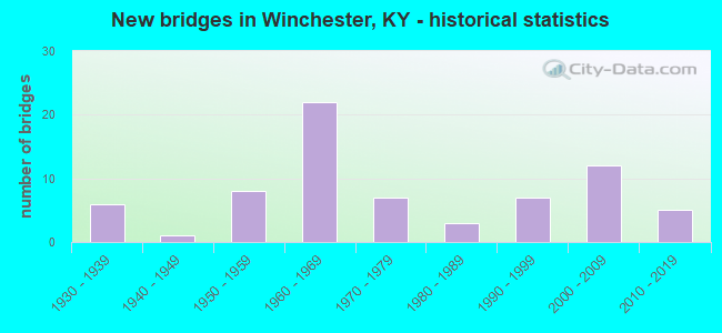
- New bridges - historical statistics
- 61930-1939
- 11940-1949
- 81950-1959
- 221960-1969
- 71970-1979
- 31980-1989
- 71990-1999
- 122000-2009
- 52010-2019
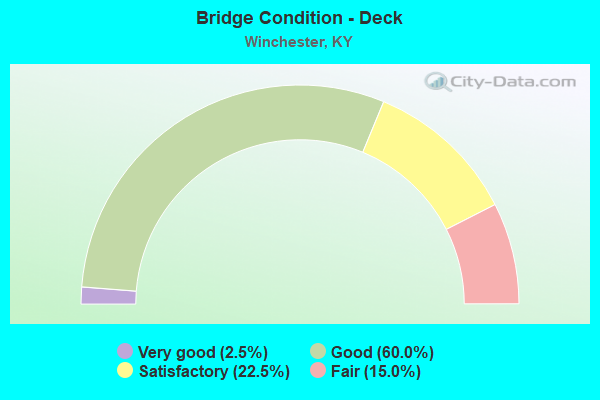
- Bridge Condition - Deck
- 2.5%Very good
- 60.0%Good
- 22.5%Satisfactory
- 15.0%Fair
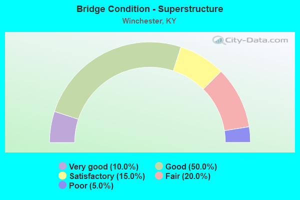
- Bridge Condition - Superstructure
- 10.0%Very good
- 50.0%Good
- 15.0%Satisfactory
- 20.0%Fair
- 5.0%Poor
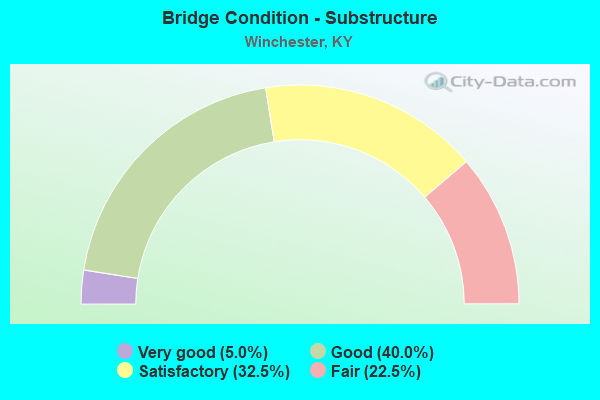
- Bridge Condition - Substructure
- 5.0%Very good
- 40.0%Good
- 32.5%Satisfactory
- 22.5%Fair
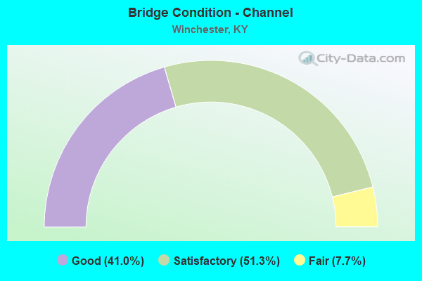
- Bridge Condition - Channel
- 41.0%Good
- 51.3%Satisfactory
- 7.7%Fair
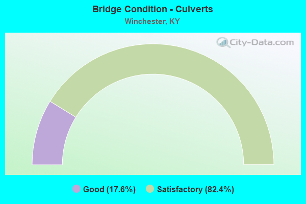
- Bridge Condition - Culverts
- 17.6%Good
- 82.4%Satisfactory
Find on map >> Show street view
Structure Number: 25C00054N, Location: .6 MI E KY 974 (Lat: 37.955000, Lng: -84.136111), Route carried "on" structure: County highway 1129, Year Built: 1992, Status: Open, Structure Length: 1.02m (3.35ft), Average Daily Traffic: 120 (year 2019), Average Future Daily Traffic: 104 (year 2039), Design Load: HS 25 or greater, Features Intersected: FOUR MILE CREEK, Facility Carried by Structure: LOGAN LICK RD
Minimum Vertical Clearance: 30+ m (98+ ft), Kilometerpoint: 1.170, Lanes on structure: 1, Owner: County Highway Agency, Approaching Roadway Width: 4.0m (13.1ft), Material/Design: Prestressed concrete, Design/Construction: Box Beam or Girders - Multiple, Number Of Spans In Main Unit: 1, Length of Maximum Span: 9.3m (30.5ft), Curb-To-Curb Width: 4.5m (14.8ft), Out-to-Out Width: 5.0m (16.4ft)
Condition: Deck: Good, Superstructure: Good, Substructure: Good, Channel: Good, Operating Rating: 62.1 metric tons, Method Used To Determine Operating Rating: Load Factor (LF), Inventory Rating: 37.3 metric tons, Method Used To Determine Inventory Rating: Load Factor (LF), Structural Evaluation: Better than present minimum criteria, Deck Geometry: High priority of replacement, Waterway Adequacy: Equal to present minimum criteria, Approach Roadway Alignment: Equal to present minimum criteria, Designated Inspection Frequency: Every 24 months, Inspection Date: August 2021, Deck Structure Type: Concrete Precast Panels, Wearing Surface/Protective System: Wearing Surface: Bituminous
Find on map >> Show street view
Structure Number: 25C00056N, Location: 1/2 MI. N LOGAN LICK RD (Lat: 37.944444, Lng: -84.119167), Route carried "on" structure: County highway 1127, Year Built: 1993, Status: Open, Structure Length: 1.10m (3.61ft), Average Daily Traffic: 181 (year 2019), Average Future Daily Traffic: 157 (year 2039), Design Load: HS 25 or greater, Features Intersected: EAST FORK, Facility Carried by Structure: OLD RUCKERVILLE RD
Minimum Vertical Clearance: 30+ m (98+ ft), Kilometerpoint: 3.109, Lanes on structure: 2, Owner: County Highway Agency, Approaching Roadway Width: 4.8m (15.7ft), Skew: 4 degrees, Material/Design: Prestressed concrete, Design/Construction: Box Beam or Girders - Multiple, Number Of Spans In Main Unit: 1, Length of Maximum Span: 10.1m (33.1ft), Curb-To-Curb Width: 6.9m (22.6ft), Out-to-Out Width: 7.4m (24.3ft)
Condition: Deck: Good, Superstructure: Good, Substructure: Satisfactory, Channel: Satisfactory, Operating Rating: 56.1 metric tons, Method Used To Determine Operating Rating: Load Factor (LF), Inventory Rating: 33.7 metric tons, Method Used To Determine Inventory Rating: Load Factor (LF), Structural Evaluation: Equal to present minimum criteria, Deck Geometry: Meets minimum limits, Waterway Adequacy: Equal to present minimum criteria, Approach Roadway Alignment: Somewhat better than minimum adequacy, Designated Inspection Frequency: Every 24 months, Inspection Date: August 2021, Deck Structure Type: Concrete Precast Panels, Wearing Surface/Protective System: Wearing Surface: Bituminous
Find on map >> Show street view
Structure Number: 25C00059N, Location: 350' N JCT KY 15 (Lat: 37.998611, Lng: -84.168611), Route carried "on" structure: City street 1007, Year Built: 1996, Status: Open, Structure Length: 4.63m (15.19ft), Average Daily Traffic: 855 (year 2018), Average Future Daily Traffic: 795 (year 2038), Design Load: HS 25 or greater, Features Intersected: CSX RAILROAD, Facility Carried by Structure: MUTUAL STREET
Minimum Vertical Clearance: 30+ m (98+ ft), Kilometerpoint: 0.520, Lanes on structure: 2, Owner: City or Municipal Highway Agency, Approaching Roadway Width: 8.5m (27.9ft), Skew: 2 degrees, Material/Design: Prestressed concrete continuous, Design/Construction: Stringer/Multi-beam, Number Of Spans In Main Unit: 3, Length of Maximum Span: 17.4m (57.1ft), Curb-To-Curb Width: 9.2m (30.2ft), Out-to-Out Width: 10.1m (33.1ft)
Condition: Deck: Good, Superstructure: Good, Substructure: Good, Operating Rating: 76.6 metric tons, Method Used To Determine Operating Rating: Load Factor (LF), Inventory Rating: 45.9 metric tons, Method Used To Determine Inventory Rating: Load Factor (LF), Structural Evaluation: Better than present minimum criteria, Deck Geometry: Equal to present minimum criteria, Underclear: High priority of corrective action, Approach Roadway Alignment: Equal to present minimum criteria, Designated Inspection Frequency: Every 24 months, Inspection Date: August 2021, Deck Structure Type: Concrete Cast-file-Place, Wearing Surface/Protective System: Wearing Surface: Monolithic Concrete, Deck Protection: Epoxy Coated Reinforcing
Find on map >> Show street view
Structure Number: 25C00062N, Location: 1.4 MI E. JCT KY 627 (Lat: 37.913611, Lng: -84.224444), Route carried "on" structure: County highway 1210, Year Built: 2001, Status: Open, Structure Length: 1.95m (6.40ft), Average Daily Traffic: 189 (year 2006), Average Future Daily Traffic: 248 (year 2026), Design Load: HS 25 or greater, Features Intersected: TWO MILE CREEK, Facility Carried by Structure: ELKIN STATION RD
Minimum Vertical Clearance: 30+ m (98+ ft), Kilometerpoint: 2.182, Lanes on structure: 2, Owner: County Highway Agency, Approaching Roadway Width: 7.9m (25.9ft), Material/Design: Prestressed concrete, Design/Construction: Box Beam or Girders - Single/Spread, Number Of Spans In Main Unit: 1, Length of Maximum Span: 18.5m (60.7ft), Curb-To-Curb Width: 8.5m (27.9ft), Out-to-Out Width: 9.4m (30.8ft)
Condition: Deck: Good, Superstructure: Good, Substructure: Satisfactory, Channel: Satisfactory, Operating Rating: 80.2 metric tons, Method Used To Determine Operating Rating: Load Factor (LF), Inventory Rating: 48.1 metric tons, Method Used To Determine Inventory Rating: Load Factor (LF), Structural Evaluation: Equal to present minimum criteria, Deck Geometry: Equal to present minimum criteria, Waterway Adequacy: Equal to present minimum criteria, Approach Roadway Alignment: Meets minimum limits, Designated Inspection Frequency: Every 24 months, Inspection Date: August 2021, Deck Structure Type: Concrete Cast-file-Place, Wearing Surface/Protective System: Wearing Surface: Bituminous, Deck Protection: Other
Find on map >> Show street view
Structure Number: 25C00064N, Location: .9 MI E JCT KY 974 (Lat: 37.934444, Lng: -84.134444), Route carried "on" structure: County highway 1130, Year Built: 2001, Status: Open, Structure Length: 1.77m (5.81ft), Average Daily Traffic: 205 (year 2019), Average Future Daily Traffic: 178 (year 2039), Design Load: HS 25 or greater, Features Intersected: EAST FK-FOUR MILE CREEK, Facility Carried by Structure: DRY FORK RD
Minimum Vertical Clearance: 30+ m (98+ ft), Kilometerpoint: 3.846, Lanes on structure: 2, Owner: County Highway Agency, Approaching Roadway Width: 4.5m (14.8ft), Material/Design: Prestressed concrete, Design/Construction: Box Beam or Girders - Multiple, Number Of Spans In Main Unit: 1, Length of Maximum Span: 16.8m (55.1ft), Curb-To-Curb Width: 6.9m (22.6ft), Out-to-Out Width: 7.4m (24.3ft)
Condition: Deck: Good, Superstructure: Satisfactory, Substructure: Good, Channel: Good, Operating Rating: 80.3 metric tons, Method Used To Determine Operating Rating: Load Factor (LF), Inventory Rating: 48.2 metric tons, Method Used To Determine Inventory Rating: Load Factor (LF), Structural Evaluation: Equal to present minimum criteria, Deck Geometry: Meets minimum limits, Waterway Adequacy: Better than present minimum criteria, Approach Roadway Alignment: Equal to present minimum criteria, Designated Inspection Frequency: Every 24 months, Inspection Date: August 2021, Deck Structure Type: Concrete Precast Panels, Wearing Surface/Protective System: Wearing Surface: Bituminous
Find on map >> Show street view
Structure Number: 25C00065N, Location: 400' N. OF MOCKINGBIR (Lat: 37.983889, Lng: -84.195556), Route carried "on" structure: City street 1091, Year Built: 2002, Status: Open, Structure Length: 0.76m (2.49ft), Average Daily Traffic: 105 (year 2006), Average Future Daily Traffic: 138 (year 2026), Design Load: HS 25 or greater, Features Intersected: LOWER HOWARDS CREEK, Facility Carried by Structure: BONNIE BROOK
Minimum Vertical Clearance: 30+ m (98+ ft), Kilometerpoint: 0.137, Lanes on structure: 2, Owner: City or Municipal Highway Agency, Approaching Roadway Width: 5.5m (18.0ft), Material/Design: Prestressed concrete, Design/Construction: Box Beam or Girders - Multiple, Number Of Spans In Main Unit: 1, Length of Maximum Span: 6.7m (22.0ft), Curb or Sidewalk Widths: Left: 0.5m (1.6ft), Right: 0.5m (1.6ft), Curb-To-Curb Width: 5.5m (18.0ft), Out-to-Out Width: 6.3m (20.7ft)
Condition: Deck: Good, Superstructure: Good, Substructure: Good, Channel: Fair, Operating Rating: 99.8 metric tons, Method Used To Determine Operating Rating: Load Factor (LF), Inventory Rating: 75.0 metric tons, Method Used To Determine Inventory Rating: Load Factor (LF), Structural Evaluation: Better than present minimum criteria, Deck Geometry: High priority of corrective action, Waterway Adequacy: Equal to present minimum criteria, Approach Roadway Alignment: Meets minimum limits, Designated Inspection Frequency: Every 24 months, Inspection Date: August 2021, Deck Structure Type: Concrete Precast Panels, Wearing Surface/Protective System: Wearing Surface: Bituminous
Find on map >> Show street view
Structure Number: 25C00066N, Location: 1.1 MI N. JCT KY 1923 (Lat: 37.958333, Lng: -84.220278), Route carried "on" structure: County highway 1244, Year Built: 2004, Status: Open, Structure Length: 3.05m (10.01ft), Average Daily Traffic: 961 (year 2019), Average Future Daily Traffic: 903 (year 2039), Design Load: HS 25 or greater, Features Intersected: HOWARDS CREEK, Facility Carried by Structure: OLD BOONESBORO NOR
Minimum Vertical Clearance: 30+ m (98+ ft), Kilometerpoint: 7.157, Lanes on structure: 2, Owner: County Highway Agency, Approaching Roadway Width: 8.1m (26.6ft), Skew: 4 degrees, Material/Design: Prestressed concrete, Design/Construction: Box Beam or Girders - Single/Spread, Number Of Spans In Main Unit: 1, Length of Maximum Span: 29.1m (95.5ft), Curb-To-Curb Width: 8.4m (27.6ft), Out-to-Out Width: 9.4m (30.8ft)
Condition: Deck: Good, Superstructure: Good, Substructure: Good, Channel: Good, Operating Rating: 96.8 metric tons, Method Used To Determine Operating Rating: Load Factor (LF), Inventory Rating: 58.1 metric tons, Method Used To Determine Inventory Rating: Load Factor (LF), Structural Evaluation: Better than present minimum criteria, Deck Geometry: Somewhat better than minimum adequacy, Waterway Adequacy: Better than present minimum criteria, Approach Roadway Alignment: Better than present minimum criteria, Designated Inspection Frequency: Every 24 months, Inspection Date: August 2021, Deck Structure Type: Concrete Cast-file-Place, Wearing Surface/Protective System: Wearing Surface: Integral Concrete, Deck Protection: Epoxy Coated Reinforcing
Find on map >> Show street view
Structure Number: 25C00068N, Location: .6 Mi. W. of Fortune Dr. (Lat: 38.010833, Lng: -84.178611), Route carried "on" structure: City street 1286, Year Built: 2002, Status: Open, Structure Length: 0.91m (2.99ft), Average Daily Traffic: 3,399 (year 2020), Average Future Daily Traffic: 3,161 (year 2040), Features Intersected: BR OF STRODES CREEK, Facility Carried by Structure: ROLLING HILLS LANE
Minimum Vertical Clearance: 30+ m (98+ ft), Kilometerpoint: 1.048, Lanes on structure: 2, Owner: City or Municipal Highway Agency, Approaching Roadway Width: 7.3m (24.0ft), Skew: 4 degrees, Material/Design: Concrete, Design/Construction: Culvert, Number Of Spans In Main Unit: 2, Length of Maximum Span: 4.3m (14.1ft)
Condition: Channel: Good, Culverts: Satisfactory, Operating Rating: 54.4 metric tons, Method Used To Determine Operating Rating: Field evaluation and documented engineering judgment, Inventory Rating: 39.9 metric tons, Method Used To Determine Inventory Rating: Field evaluation and documented engineering judgment, Structural Evaluation: Equal to present minimum criteria, Waterway Adequacy: Better than present minimum criteria, Approach Roadway Alignment: Equal to present minimum criteria, Designated Inspection Frequency: Every 24 months, Inspection Date: August 2021
Find on map >> Show street view
Structure Number: 25C00069N, Location: .8 Mi. W. of Fortune Dr. (Lat: 38.010000, Lng: -84.181389), Route carried "on" structure: City street 1286, Year Built: 2002, Status: Open, Structure Length: 0.82m (2.69ft), Average Daily Traffic: 3,399 (year 2020), Average Future Daily Traffic: 3,161 (year 2040), Features Intersected: BR. OF STRODES CREEK, Facility Carried by Structure: ROLLING HILLS LANE
Minimum Vertical Clearance: 30+ m (98+ ft), Kilometerpoint: 1.323, Lanes on structure: 2, Owner: City or Municipal Highway Agency, Approaching Roadway Width: 7.3m (24.0ft), Skew: 1 degrees, Material/Design: Concrete, Design/Construction: Culvert, Number Of Spans In Main Unit: 2, Length of Maximum Span: 3.9m (12.8ft)
Condition: Channel: Satisfactory, Culverts: Satisfactory, Operating Rating: 54.4 metric tons, Method Used To Determine Operating Rating: Field evaluation and documented engineering judgment, Inventory Rating: 39.9 metric tons, Method Used To Determine Inventory Rating: Field evaluation and documented engineering judgment, Structural Evaluation: Equal to present minimum criteria, Waterway Adequacy: Better than present minimum criteria, Approach Roadway Alignment: Equal to present minimum criteria, Designated Inspection Frequency: Every 24 months, Inspection Date: August 2021
Find on map >> Show street view
Structure Number: 25C00070N, Location: .9 Mi. W. of Fortune Dr. (Lat: 38.009722, Lng: -84.184444), Route carried "on" structure: City street 1286, Year Built: 2002, Status: Open, Structure Length: 4.30m (14.11ft), Average Daily Traffic: 3,061 (year 2020), Average Future Daily Traffic: 2,846 (year 2040), Design Load: HS 25 or greater, Features Intersected: CSX RR, Facility Carried by Structure: ROLLING HILLS LANE
Minimum Vertical Clearance: 30+ m (98+ ft), Kilometerpoint: 1.600, Lanes on structure: 2, Owner: City or Municipal Highway Agency, Approaching Roadway Width: 7.0m (23.0ft), Material/Design: Prestressed concrete continuous, Design/Construction: Stringer/Multi-beam, Number Of Spans In Main Unit: 2, Length of Maximum Span: 25.5m (83.7ft), Curb-To-Curb Width: 14.1m (46.3ft), Out-to-Out Width: 15.0m (49.2ft)
Condition: Deck: Good, Superstructure: Very good, Substructure: Good, Operating Rating: 79.9 metric tons, Method Used To Determine Operating Rating: Load Factor (LF), Inventory Rating: 48.0 metric tons, Method Used To Determine Inventory Rating: Load Factor (LF), Structural Evaluation: Better than present minimum criteria, Deck Geometry: Superior to present desirable criteria, Underclear: Better than present minimum criteria, Approach Roadway Alignment: Better than present minimum criteria, Designated Inspection Frequency: Every 24 months, Inspection Date: August 2021, Deck Structure Type: Concrete Cast-file-Place, Wearing Surface/Protective System: Wearing Surface: Monolithic Concrete, Deck Protection: Epoxy Coated Reinforcing
Find on map >> Show street view
Structure Number: 25C00071N, Location: 1.1 Mi. W. of Fortune Dr. (Lat: 38.010000, Lng: -84.188333), Route carried "on" structure: City street 1286, Year Built: 2002, Status: Open, Structure Length: 1.34m (4.40ft), Average Daily Traffic: 3,061 (year 2020), Average Future Daily Traffic: 2,846 (year 2040), Design Load: HS 25 or greater, Features Intersected: BR. OF STRODES CREEK, Facility Carried by Structure: ROLLING HILLS LANE
Minimum Vertical Clearance: 30+ m (98+ ft), Kilometerpoint: 1.970, Lanes on structure: 2, Owner: City or Municipal Highway Agency, Approaching Roadway Width: 6.7m (22.0ft), Material/Design: Prestressed concrete, Design/Construction: Box Beam or Girders - Multiple, Number Of Spans In Main Unit: 1, Length of Maximum Span: 12.2m (40.0ft), Curb-To-Curb Width: 10.6m (34.8ft), Out-to-Out Width: 11.1m (36.4ft)
Condition: Deck: Good, Superstructure: Very good, Substructure: Good, Channel: Good, Operating Rating: 65.8 metric tons, Method Used To Determine Operating Rating: Load Factor (LF), Inventory Rating: 39.5 metric tons, Method Used To Determine Inventory Rating: Load Factor (LF), Structural Evaluation: Better than present minimum criteria, Deck Geometry: Somewhat better than minimum adequacy, Waterway Adequacy: Better than present minimum criteria, Approach Roadway Alignment: Better than present minimum criteria, Designated Inspection Frequency: Every 24 months, Inspection Date: August 2021, Deck Structure Type: Concrete Cast-file-Place, Wearing Surface/Protective System: Wearing Surface: Monolithic Concrete, Deck Protection: Epoxy Coated Reinforcing
Find on map >> Show street view
Structure Number: 25C00072N, Location: 2.1 Mi. W. of Fortune Dr. (Lat: 38.015833, Lng: -84.203889), Route carried "on" structure: County highway 1302, Year Built: 2008, Status: Open, Structure Length: 2.00m (6.56ft), Average Daily Traffic: 3,061 (year 2020), Average Future Daily Traffic: 2,846 (year 2040), Design Load: HS 25 or greater, Features Intersected: BR. OF STRODES CREEK, Facility Carried by Structure: ROLLING HILLS LANE
Minimum Vertical Clearance: 30+ m (98+ ft), Kilometerpoint: 0.190, Lanes on structure: 2, Owner: County Highway Agency, Approaching Roadway Width: 6.7m (22.0ft), Material/Design: Prestressed concrete, Design/Construction: Box Beam or Girders - Multiple, Number Of Spans In Main Unit: 1, Length of Maximum Span: 18.9m (62.0ft), Curb-To-Curb Width: 10.5m (34.4ft), Out-to-Out Width: 11.0m (36.1ft)
Condition: Deck: Good, Superstructure: Very good, Substructure: Good, Channel: Good, Operating Rating: 81.6 metric tons, Method Used To Determine Operating Rating: Load Factor (LF), Inventory Rating: 48.9 metric tons, Method Used To Determine Inventory Rating: Load Factor (LF), Structural Evaluation: Better than present minimum criteria, Deck Geometry: Somewhat better than minimum adequacy, Waterway Adequacy: Better than present minimum criteria, Approach Roadway Alignment: Better than present minimum criteria, Designated Inspection Frequency: Every 24 months, Inspection Date: August 2021, Deck Structure Type: Concrete Cast-file-Place, Wearing Surface/Protective System: Wearing Surface: Monolithic Concrete, Deck Protection: Epoxy Coated Reinforcing
Find on map >> Show street view
Structure Number: 25C00073N, Location: 100' E Rockwell Rd. (Lat: 38.013889, Lng: -84.207222), Route carried "on" structure: County highway 1302, Year Built: 2008, Status: Open, Structure Length: 5.97m (19.59ft), Average Daily Traffic: 3,061 (year 2020), Average Future Daily Traffic: 2,846 (year 2040), Design Load: HS 25 or greater, Features Intersected: CSX RR, Facility Carried by Structure: ROLLING HILLS LANE
Minimum Vertical Clearance: 30+ m (98+ ft), Kilometerpoint: 0.525, Lanes on structure: 3, Owner: County Highway Agency, Approaching Roadway Width: 32.9m (107.9ft), Skew: 20 degrees, Material/Design: Prestressed concrete continuous, Design/Construction: Stringer/Multi-beam, Number Of Spans In Main Unit: 3, Length of Maximum Span: 25.9m (85.0ft), Curb-To-Curb Width: 32.9m (107.9ft), Out-to-Out Width: 33.8m (110.9ft)
Condition: Deck: Good, Superstructure: Very good, Substructure: Good, Operating Rating: 82.6 metric tons, Method Used To Determine Operating Rating: Load Factor (LF), Inventory Rating: 49.5 metric tons, Method Used To Determine Inventory Rating: Load Factor (LF), Structural Evaluation: Better than present minimum criteria, Deck Geometry: Superior to present desirable criteria, Underclear: Superior to present desirable criteria, Approach Roadway Alignment: Better than present minimum criteria, Designated Inspection Frequency: Every 24 months, Inspection Date: August 2021, Deck Structure Type: Concrete Cast-file-Place, Wearing Surface/Protective System: Wearing Surface: Monolithic Concrete, Deck Protection: Epoxy Coated Reinforcing
Find on map >> Show street view
Structure Number: 25C00074N, Location: .2 M W OF OLD BOONESBORO (Lat: 37.971111, Lng: -84.209444), Route carried "on" structure: County highway 1256, Year Built: 1981, Status: Posted for load, Structure Length: 0.79m (2.59ft), Average Daily Traffic: 499 (year 2015), Average Future Daily Traffic: 654 (year 2035), Features Intersected: BRANCH OF HOWARDS CREEK, Facility Carried by Structure: CALMES BLVD
Minimum Vertical Clearance: 30+ m (98+ ft), Kilometerpoint: 0.441, Lanes on structure: 1, Owner: County Highway Agency, Approaching Roadway Width: 9.7m (31.8ft), Material/Design: Concrete, Design/Construction: Culvert, Number Of Spans In Main Unit: 2, Length of Maximum Span: 3.8m (12.5ft)
Condition: Channel: Good, Culverts: Good, Operating Rating: 16.4 metric tons, Method Used To Determine Operating Rating: Field evaluation and documented engineering judgment, Inventory Rating: 16.4 metric tons, Method Used To Determine Inventory Rating: Field evaluation and documented engineering judgment, Structural Evaluation: Somewhat better than minimum adequacy, Waterway Adequacy: Superior to present desirable criteria, Approach Roadway Alignment: Equal to present desirable criteria, Bridge Posting: Required (Relationship of Operating Rating to Maximum Legal Load: > 39.9% below), Designated Inspection Frequency: Every 24 months, Inspection Date: August 2021
Find on map >> Show street view
Structure Number: 25B00044N, Location: 1.5 MI E OF JCT KY 15 (Lat: 38.005278, Lng: -84.137222), Route carried "under" structure: State highway 9000, Year Built: 1962, Structure Length: 0. m, Average Daily Traffic: 12,941 (year 2020), Truck Traffic: 8%, Features Intersected: MOUNTAIN PARKWAY, Facility Carried by Structure: KY-1960
Minimum Vertical Clearance: 4.83m (15.85ft), Kilometerpoint: 2.139, Lanes on structure: 2, Lanes under structure: 4, Material/Design: Concrete continuous, Design/Construction: Tee Beam, Length of Maximum Span: 17.7m (58.1ft)
Find on map >> Show street view
Structure Number: 25B00047N, Location: .90 MI WEST OF KY 627 NTR (Lat: 38.007222, Lng: -84.188889), Route carried "under" structure: Interstate 64, Year Built: 1962, Structure Length: 0. m, Average Daily Traffic: 48,197 (year 2018), Truck Traffic: 13%, Features Intersected: INTERSTATE 64, Facility Carried by Structure: CSX RAILROAD
Minimum Vertical Clearance: 5.61m (18.41ft), Kilometerpoint: 153.485, Lanes under structure: 6, Material/Design: Steel, Design/Construction: Stringer/Multi-beam, Length of Maximum Span: 29.3m (96.1ft)
Find on map >> Show street view
Structure Number: 25B00048N, Location: .50 MI WEST OF KY 627 NTR (Lat: 38.008611, Lng: -84.183889), Route carried "under" structure: Interstate 64, Year Built: 1962, Structure Length: 0. m, Average Daily Traffic: 48,197 (year 2018), Truck Traffic: 13%, Features Intersected: INTERSTATE 64, Facility Carried by Structure: CSX RAILROAD
Minimum Vertical Clearance: 5.39m (17.68ft), Kilometerpoint: 153.939, Lanes under structure: 6, Material/Design: Steel, Design/Construction: Stringer/Multi-beam, Length of Maximum Span: 20.4m (66.9ft)
Find on map >> Show street view
Structure Number: 25B00051N, Location: 1.6 MI E OF EXT 101 (Lat: 38.024444, Lng: -84.120833), Route carried "under" structure: Interstate 64, Year Built: 1959, Structure Length: 0. m, Average Daily Traffic: 29,359 (year 2018), Truck Traffic: 16%, Features Intersected: I-64, Facility Carried by Structure: CABIN CREEK RD
Minimum Vertical Clearance: 6.19m (20.31ft), Kilometerpoint: 159.748, Lanes on structure: 2, Lanes under structure: 4, Material/Design: Concrete continuous, Design/Construction: Tee Beam, Length of Maximum Span: 28.3m (92.8ft)
Find on map >> Show street view
Structure Number: 25B00055N, Location: WBL OVR I-64 INTERCHANGE (Lat: 38.019444, Lng: -84.149167), Route carried "under" structure: Interstate 64, Year Built: 1962, Structure Length: 0. m, Average Daily Traffic: 29,359 (year 2018), Truck Traffic: 16%, Features Intersected: I-64, Facility Carried by Structure: MOUNTAIN PKY NC
Minimum Vertical Clearance: 6.35m (20.83ft), Kilometerpoint: 157.201, Lanes on structure: 4, Lanes under structure: 5, Material/Design: Steel, Design/Construction: Stringer/Multi-beam, Length of Maximum Span: 29.8m (97.8ft)
Find on map >> Show street view
Structure Number: 25B00056L, Location: WBL 2.2 MI E-I64 NTRCH (Lat: 37.995833, Lng: -84.118889), Route carried "under" structure: County highway 1004, Year Built: 1962, Structure Length: 0. m, Average Daily Traffic: 108 (year 2006), Features Intersected: MORRIS ROAD, Facility Carried by Structure: MOUNTAIN PKY NC
Minimum Vertical Clearance: 4.57m (14.99ft), Kilometerpoint: 1.061, Lanes on structure: 2, Lanes under structure: 2, Material/Design: Concrete, Design/Construction: Tee Beam, Length of Maximum Span: 15.2m (49.9ft)
Find on map >> Show street view
Structure Number: 25B00056R, Location: EBL 2.2 MI E-I64 NTRCH (Lat: 37.995556, Lng: -84.118889), Route carried "under" structure: County highway 1004, Year Built: 1962, Structure Length: 0. m, Average Daily Traffic: 108 (year 2006), Features Intersected: MORRIS ROAD, Facility Carried by Structure: KY-9000 MTN PKWY
Minimum Vertical Clearance: 4.42m (14.50ft), Kilometerpoint: 1.041, Lanes on structure: 2, Lanes under structure: 2, Material/Design: Concrete, Design/Construction: Tee Beam, Length of Maximum Span: 15.2m (49.9ft)
Find on map >> Show street view
Structure Number: 25B00074N, Location: .5MI N OF US 60 (Lat: 37.998333, Lng: -84.176389), Route carried "under" structure: State highway 627, Year Built: 1964, Structure Length: 0. m, Average Daily Traffic: 10,302 (year 2019), Truck Traffic: 10%, Features Intersected: KY 627, Facility Carried by Structure: CSX RAILROAD
Minimum Vertical Clearance: 4.85m (15.91ft), Kilometerpoint: 13.358, Lanes under structure: 4, Material/Design: Steel, Design/Construction: Stringer/Multi-beam, Length of Maximum Span: 14.3m (46.9ft)
Find on map >> Show street view
Structure Number: 25B00105N, Location: 0.2 MI N OF JCT US 60 (Lat: 38.011111, Lng: -84.208611), Route carried "under" structure: Interstate 64, Year Built: 2006, Structure Length: 0. m, Average Daily Traffic: 40,128 (year 2017), Truck Traffic: 14%, Features Intersected: INTERSTATE 64, Facility Carried by Structure: KY 1958
Minimum Vertical Clearance: 30+ m (98+ ft), Kilometerpoint: 151.634, Lanes on structure: 6, Lanes under structure: 6, Material/Design: Prestressed concrete continuous, Design/Construction: Stringer/Multi-beam, Length of Maximum Span: 39.6m (129.9ft)
Find on map >> Show street view
Structure Number: 25B00107N, Location: 1.7 MI W OF JCT W/KY 1961 (Lat: 38.016944, Lng: -84.156944), Route carried "under" structure: Interstate 64, Year Built: 2011, Structure Length: 0. m, Average Daily Traffic: 30,556 (year 2020), Truck Traffic: 15%, Features Intersected: I-64, Facility Carried by Structure: US 60
Minimum Vertical Clearance: 6.49m (21.29ft), Kilometerpoint: 156.448, Lanes on structure: 2, Lanes under structure: 6, Material/Design: Prestressed concrete, Design/Construction: Stringer/Multi-beam, Length of Maximum Span: 41.0m (134.5ft)
Find on map >> Show street view
Structure Number: 25B00108N, Location: 1MI W of US.60 OVERPASS (Lat: 38.011944, Lng: -84.173889), Route carried "under" structure: Interstate 64, Year Built: 2011, Structure Length: 0. m, Average Daily Traffic: 48,197 (year 2018), Truck Traffic: 13%, Features Intersected: I-64, Facility Carried by Structure: KY 627
Minimum Vertical Clearance: 6.04m (19.82ft), Kilometerpoint: 154.874, Lanes on structure: 4, Lanes under structure: 6, Material/Design: Prestressed concrete continuous, Design/Construction: Stringer/Multi-beam, Length of Maximum Span: 41.1m (134.8ft)
Find on map >> Show street view
Structure Number: 25B00108N, Location: 1MI W of US.60 OVERPASS (Lat: 38.011944, Lng: -84.173889), Route carried "under" structure: Ramp Interstate 64, Year Built: 2011, Structure Length: 0. m, Average Daily Traffic: 48,197 (year 2018), Truck Traffic: 13%, Features Intersected: I-64, Facility Carried by Structure: KY 627
Minimum Vertical Clearance: 6.04m (19.82ft), Kilometerpoint: 154.874, Lanes on structure: 4, Lanes under structure: 1, Material/Design: Prestressed concrete continuous, Design/Construction: Stringer/Multi-beam, Length of Maximum Span: 41.1m (134.8ft)
Find on map >> Show street view
Structure Number: 25R00605N, Location: 500 FT NOR JCT KY 1958 (Lat: 38.015556, Lng: -84.211389), Route carried "under" structure: County highway 1310, Year Built: 1930, Structure Length: 0. m, Average Daily Traffic: 511 (year 2006), Features Intersected: VAN METER RD., Facility Carried by Structure: CSX RR
Minimum Vertical Clearance: 4.19m (13.75ft), Kilometerpoint: 0.190, Lanes under structure: 2, Material/Design: Steel, Design/Construction: Stringer/Multi-beam, Length of Maximum Span: 11.5m (37.7ft)
Find on map >> Show street view
Structure Number: 25R00607N, Location: .1 M S OF LOGAN LICK RD (Lat: 37.950556, Lng: -84.123056), Route carried "under" structure: County highway 1127, Year Built: 1945, Structure Length: 0. m, Average Daily Traffic: 143 (year 2006), Features Intersected: OLD RUCKERVILLE RD., Facility Carried by Structure: CSX RAILROAD
Minimum Vertical Clearance: 5.69m (18.67ft), Kilometerpoint: 4.117, Lanes under structure: 2, Material/Design: Concrete, Design/Construction: Stringer/Multi-beam, Length of Maximum Span: 13.7m (44.9ft)