Caswell, Maine
Submit your own pictures of this town and show them to the world
- OSM Map
- Google Map
- MSN Map
Population change since 2000: -6.1%
 |
| Males: 153 | |
| Females: 153 |
| Median resident age: | 45.3 years |
| Maine median age: | 43.0 years |
Zip codes: 04750.
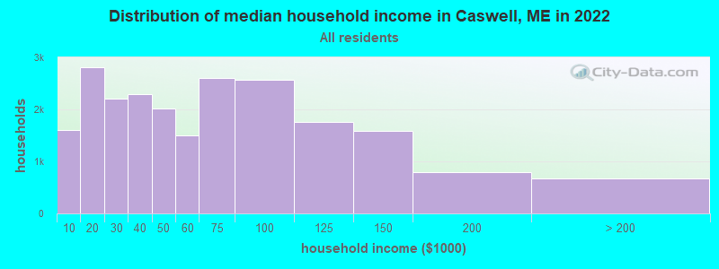
| Caswell: | $36,759 |
| ME: | $69,543 |
Estimated per capita income in 2022: $27,073 (it was $13,118 in 2000)
Caswell town income, earnings, and wages data
Estimated median house or condo value in 2022: $96,849 (it was $40,000 in 2000)
| Caswell: | $96,849 |
| ME: | $290,600 |
Mean prices in 2022: all housing units: $179,108; detached houses: $185,023; townhouses or other attached units: $218,327; in 2-unit structures: $262,505; in 3-to-4-unit structures: $121,406; in 5-or-more-unit structures: $185,084; mobile homes: $117,009; occupied boats, rvs, vans, etc.: $12,682
Detailed information about poverty and poor residents in Caswell, ME
Compare current foreclosures near Caswell, ME:
| Photo | Address | Area | Beds / Baths | Price | Details |
|---|---|---|---|---|---|

|
#1
Dorsey Rd
Fort Fairfield, ME 04742
|
1,344 sq. feet
|
1 baths 3 beds |
show details | |

|
#2
Belanger Rd
Caribou, ME 04736
|
1,268 sq. feet
|
1 baths 3 beds |
show details | |

|
#3
Limestone Rd
Fort Fairfield, ME 04742
|
972 sq. feet
|
2 baths 3 beds |
show details | |

|
#4
Glendale Rd
Caribou, ME 04736
|
940 sq. feet
|
1 baths 3 beds |
show details | |

|
#5
S Park St
Caribou, ME 04736
|
1,684 sq. feet
|
2 baths 3 beds |
show details | |

|
#6
Columbia Ave
Fort Fairfield, ME 04742
|
1,612 sq. feet
|
1 baths 3 beds |
show details | |

|
#7
Limestone Rd
Fort Fairfield, ME 04742
|
780 sq. feet
|
1 baths 3 beds |
show details | |

|
#8
Washburn St
Caribou, ME 04736
|
1,739 sq. feet
|
2 baths 3 beds |
show details | |

|
#9
Washburn St
Caribou, ME 04736
|
1,890 sq. feet
|
4 baths - beds |
show details | |

|
#10
Carson Rd
Caribou, ME 04736
|
- sq. feet
|
- baths - beds |
show details |
| Photo | Address | Area | Beds / Baths | Price | Details |
|---|---|---|---|---|---|

|
#11
Huggard Ave
Limestone, ME 04750
|
- sq. feet
|
- baths - beds |
show details | |

|
#12
Sweden St
Caribou, ME 04736
|
- sq. feet
|
- baths - beds |
show details | |

|
#13
Center Limestone Rd
Fort Fairfield, ME 04742
|
- sq. feet
|
- baths - beds |
show details | |

|
#14
Lincoln St
Van Buren, ME 04785
|
- sq. feet
|
- baths - beds |
show details | |

|
#15
Access Hwy
Limestone, ME 04750
|
- sq. feet
|
- baths - beds |
show details | |

|
#16
Champlain St
Van Buren, ME 04785
|
- sq. feet
|
- baths - beds |
show details | |

|
#17
Sam Everett Rd
Fort Fairfield, ME 04742
|
- sq. feet
|
- baths - beds |
show details | |

|
#18
Bog Rd
Limestone, ME 04750
|
- sq. feet
|
- baths - beds |
show details | |

|
#19
Nutting Rd
Perham, ME 04766
|
- sq. feet
|
- baths - beds |
show details | |

|
Check over 1 million property listings on Foreclosure.com!
|
browse all offers | |||

- 29496.1%White alone
- 82.6%American Indian alone
- 20.7%Two or more races
- 10.3%Black alone
- 10.3%Hispanic
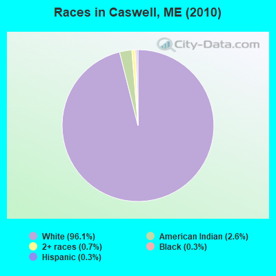
Races in Caswell detailed stats: ancestries, foreign born residents, place of birth
According to our research of Maine and other state lists, there were 2 registered sex offenders living in Caswell, Maine as of June 16, 2024.
The ratio of all residents to sex offenders in Caswell is 153 to 1.
 Recent articles from our blog. Our writers, many of them Ph.D. graduates or candidates, create easy-to-read articles on a wide variety of topics.
Ancestries: French (27.3%), United States (20.6%), French Canadian (18.4%), Irish (11.0%), English (8.6%), German (2.8%).
Current Local Time: EST time zone
Incorporated on 04/14/1879
Land area: 41.5 square miles.
Population density: 7.4 people per square mile (very low).
16 residents are foreign born (4.9% North America).
| This town: | 4.9% |
| Maine: | 2.9% |
| Caswell town: | 1.2% ($483) |
| Maine: | 1.5% ($1,417) |
Nearest city with pop. 50,000+: Portland, ME  (257.4 miles , pop. 64,249).
Nearest city with pop. 200,000+: Boston, MA (359.2 miles , pop. 589,141).
Nearest city with pop. 1,000,000+: Bronx, NY (519.0 miles , pop. 1,332,650).
Nearest cities:
), ), ), ), ), )Latitude: 46.98 N, Longitude: 67.86 W
Area code commonly used in this area: 207
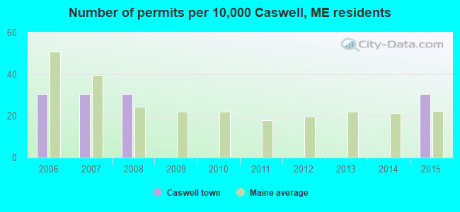
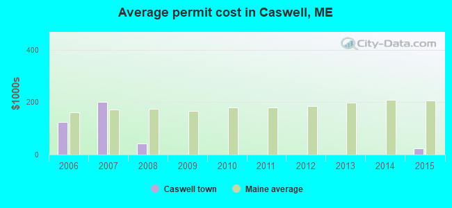
Single-family new house construction building permits:
- 2015: 1 building, cost: $25,000
- 2008: 1 building, cost: $42,000
- 2007: 1 building, cost: $201,000
- 2006: 1 building, cost: $125,000
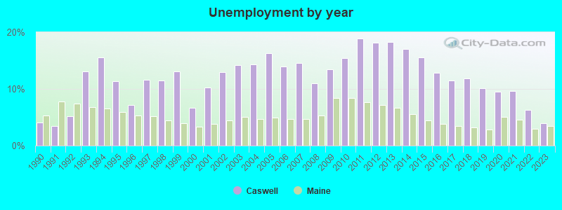
| Here: | 3.9% |
| Maine: | 3.4% |
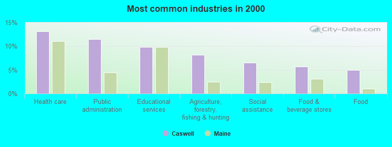
- Health care (13.1%)
- Public administration (11.5%)
- Educational services (9.8%)
- Agriculture, forestry, fishing & hunting (8.2%)
- Social assistance (6.6%)
- Food & beverage stores (5.7%)
- Food (4.9%)
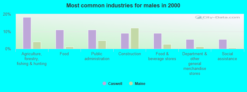
- Agriculture, forestry, fishing & hunting (18.2%)
- Food (10.9%)
- Public administration (10.9%)
- Construction (9.1%)
- Food & beverage stores (9.1%)
- Department & other general merchandise stores (5.5%)
- Social assistance (5.5%)
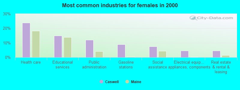
- Health care (23.9%)
- Educational services (14.9%)
- Public administration (11.9%)
- Gasoline stations (9.0%)
- Social assistance (7.5%)
- Electrical equipment, appliances, components (4.5%)
- Real estate & rental & leasing (4.5%)
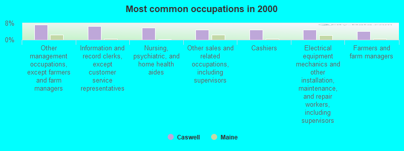
- Other management occupations, except farmers and farm managers (7.4%)
- Information and record clerks, except customer service representatives (6.6%)
- Nursing, psychiatric, and home health aides (5.7%)
- Other sales and related occupations, including supervisors (4.9%)
- Cashiers (4.9%)
- Electrical equipment mechanics and other installation, maintenance, and repair workers, including supervisors (4.9%)
- Farmers and farm managers (4.1%)
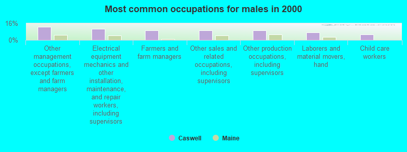
- Other management occupations, except farmers and farm managers (12.7%)
- Electrical equipment mechanics and other installation, maintenance, and repair workers, including supervisors (10.9%)
- Farmers and farm managers (9.1%)
- Other sales and related occupations, including supervisors (9.1%)
- Other production occupations, including supervisors (9.1%)
- Laborers and material movers, hand (7.3%)
- Child care workers (5.5%)

- Nursing, psychiatric, and home health aides (10.4%)
- Information and record clerks, except customer service representatives (9.0%)
- Cashiers (9.0%)
- Counselors, social workers, and other community and social service specialists (7.5%)
- Building and grounds cleaning and maintenance occupations (6.0%)
- Secretaries and administrative assistants (6.0%)
- Other food preparation and serving workers, including supervisors (6.0%)
Average climate in Caswell, Maine
Based on data reported by over 4,000 weather stations


(lower is better)
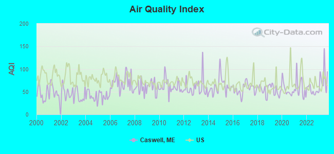
Air Quality Index (AQI) level in 2023 was 79.3. This is about average.
| City: | 79.3 |
| U.S.: | 72.6 |
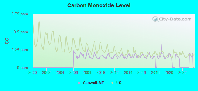
Carbon Monoxide (CO) [ppm] level in 2021 was 0.155. This is significantly better than average. Closest monitor was 21.3 miles away from the city center.
| City: | 0.155 |
| U.S.: | 0.251 |
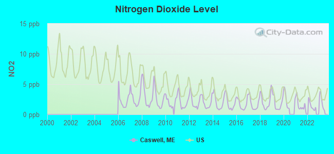
Nitrogen Dioxide (NO2) [ppb] level in 2022 was 1.41. This is significantly better than average. Closest monitor was 21.3 miles away from the city center.
| City: | 1.41 |
| U.S.: | 5.11 |
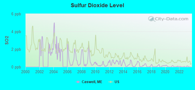
Sulfur Dioxide (SO2) [ppb] level in 2022 was 0.0234. This is significantly better than average. Closest monitor was 21.3 miles away from the city center.
| City: | 0.0234 |
| U.S.: | 1.5147 |
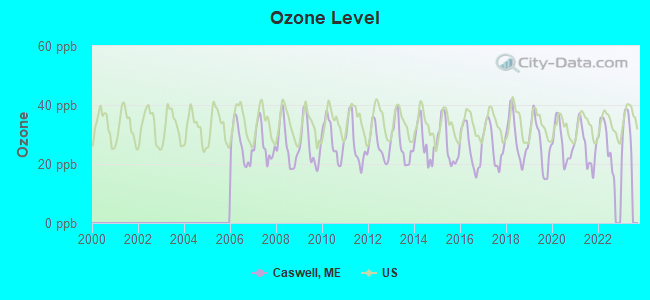
Ozone [ppb] level in 2022 was 27.2. This is better than average. Closest monitor was 10.6 miles away from the city center.
| City: | 27.2 |
| U.S.: | 33.3 |
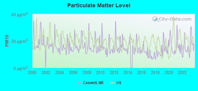
Particulate Matter (PM10) [µg/m3] level in 2023 was 19.0. This is about average. Closest monitor was 12.3 miles away from the city center.
| City: | 19.0 |
| U.S.: | 19.2 |
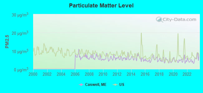
Particulate Matter (PM2.5) [µg/m3] level in 2023 was 6.41. This is better than average. Closest monitor was 21.2 miles away from the city center.
| City: | 6.41 |
| U.S.: | 8.11 |
Earthquake activity:
Caswell-area historical earthquake activity is above Maine state average. It is 88% smaller than the overall U.S. average.On 7/14/2006 at 09:34:48, a magnitude 3.9 (3.9 MD, Depth: 8.6 mi, Class: Light, Intensity: II - III) earthquake occurred 39.5 miles away from the city center
On 4/20/2002 at 10:50:47, a magnitude 5.3 (5.3 ML, Depth: 3.0 mi, Class: Moderate, Intensity: VI - VII) earthquake occurred 329.1 miles away from Caswell center
On 4/20/2002 at 10:50:47, a magnitude 5.2 (5.2 MB, 4.2 MS, 5.2 MW, 5.0 MW) earthquake occurred 331.0 miles away from Caswell center
On 10/16/2012 at 23:12:25, a magnitude 4.7 (4.7 ML, Depth: 10.0 mi, Class: Light, Intensity: IV - V) earthquake occurred 270.6 miles away from the city center
On 10/7/1983 at 10:18:46, a magnitude 5.3 (5.1 MB, 5.3 LG, 5.1 ML) earthquake occurred 377.4 miles away from the city center
On 1/19/1982 at 00:14:42, a magnitude 4.7 (4.5 MB, 4.7 MD, 4.5 LG) earthquake occurred 301.7 miles away from Caswell center
Magnitude types: regional Lg-wave magnitude (LG), body-wave magnitude (MB), duration magnitude (MD), local magnitude (ML), surface-wave magnitude (MS), moment magnitude (MW)
Natural disasters:
The number of natural disasters in Aroostook County (22) is greater than the US average (15).Major Disasters (Presidential) Declared: 13
Emergencies Declared: 9
Causes of natural disasters: Floods: 10, Storms: 8, Snows: 7, Heavy Rains: 2, Blizzard: 1, Hurricane: 1, Ice Storm: 1, Snowfall: 1, Snowstorm: 1, Wind: 1, Winter Storm: 1, Other: 2 (Note: some incidents may be assigned to more than one category).
Hospitals and medical centers near Caswell:
- VISITING NURSES OF AROOSTOOK (Home Health Center, about 10 miles away; CARIBOU, ME)
- CARY MEDICAL CENTER Acute Care Hospitals (about 10 miles away; CARIBOU, ME)
- MAINE VETERANS HOME - CARIBOU (Nursing Home, about 10 miles away; CARIBOU, ME)
- CARIBOU REHAB AND NURSING CENTER (Nursing Home, about 11 miles away; CARIBOU, ME)
- PROFESSIONAL HOME NURSING INC (Home Health Center, about 12 miles away; CARIBOU, ME)
- VALLEY HOME HEALTH SERVICES (Home Health Center, about 12 miles away; CARIBOU, ME)
- BORDERVIEW REHAB AND LIVING CTR (Nursing Home, about 12 miles away; VAN BUREN, ME)
Colleges/universities with over 2000 students nearest to Caswell:
- University of Maine (about 150 miles; Orono, ME; Full-time enrollment: 8,931)
- Husson University (about 156 miles; Bangor, ME; FT enrollment: 2,421)
- University of Maine at Farmington (about 195 miles; Farmington, ME; FT enrollment: 2,036)
- University of Maine at Augusta (about 206 miles; Augusta, ME; FT enrollment: 3,204)
- Saint Joseph's College of Maine (about 253 miles; Standish, ME; FT enrollment: 2,010)
- Southern Maine Community College (about 258 miles; South Portland, ME; FT enrollment: 4,666)
- University of Southern Maine (about 258 miles; Portland, ME; FT enrollment: 6,647)
Public elementary/middle school in Caswell:
- DAWN F BARNES ELEMENTARY SCH (Students: 50, Location: 1025 VAN BUREN ROAD, Grades: PK-8)
Points of interest:
Notable location: Caswell Plantation (A). Display/hide its location on the map
Cemeteries: Howland Family Cemetery (1), Houghton Cemetery (2), Caldwell Cemetery (3). Display/hide their locations on the map
Lakes, reservoirs, and swamps: Big Black Brook Lake (A), Butterfield Lake (B), Deer Lake (C), Gerard Pond (D), Little Black Brook Lake (E), Martin Lake (F), Mud Lake (G), Pierce Lake (H). Display/hide their locations on the map
Streams, rivers, and creeks: Willard Brook (A), Masters Brook (B), Daggett Brook (C). Display/hide their locations on the map
Drinking water stations with addresses in Caswell and their reported violations in the past:
CASWELL ELEM/AKA DAWN BARNES (Population served: 56, Groundwater):Past health violations:Past monitoring violations:
- MCL, Monthly (TCR) - In SEP-2008, Contaminant: Coliform. Follow-up actions: St Public Notif requested (SEP-02-2008), St Formal NOV issued (SEP-02-2008), St Public Notif received (SEP-12-2008), St Compliance achieved (SEP-01-2011)
- 2 routine major monitoring violations
- 23 regular monitoring violations
| This town: | 2.3 people |
| Maine: | 2.3 people |
| This town: | 67.9% |
| Whole state: | 62.9% |
| This town: | 11.9% |
| Whole state: | 9.4% |
Likely homosexual households (counted as self-reported same-sex unmarried-partner households)
- Lesbian couples: 1.5% of all households
- Gay men: 0.0% of all households
| This town: | 19.8% |
| Whole state: | 10.9% |
| This town: | 3.8% |
| Whole state: | 4.1% |
For population 15 years and over in Caswell:
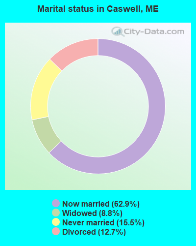
- Never married: 15.5%
- Now married: 62.9%
- Separated: 0.0%
- Widowed: 8.8%
- Divorced: 12.7%
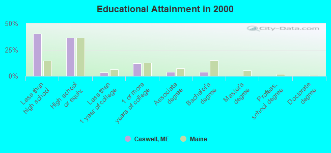
For population 25 years and over in Caswell:
- High school or higher: 59.8%
- Bachelor's degree or higher: 3.9%
- Graduate or professional degree: 0.0%
- Unemployed: 15.9%
- Mean travel time to work (commute): 20.5 minutes
| Here: | 12.6 |
| Maine average: | 11.2 |


Graphs represent county-level data. Detailed 2008 Election Results
Religion statistics for Caswell, ME (based on Aroostook County data)


| Religion | Adherents | Congregations |
|---|---|---|
| Catholic | 22,200 | 27 |
| Mainline Protestant | 5,845 | 40 |
| Evangelical Protestant | 4,411 | 51 |
| Other | 957 | 7 |
| Orthodox | 10 | 1 |
| None | 38,447 | - |
Food Environment Statistics:
| This county: | 4.03 / 10,000 pop. |
| Maine: | 2.80 / 10,000 pop. |
| This county: | 0.14 / 10,000 pop. |
| Maine: | 0.14 / 10,000 pop. |
| Aroostook County: | 2.22 / 10,000 pop. |
| State: | 2.20 / 10,000 pop. |
| Aroostook County: | 7.78 / 10,000 pop. |
| Maine: | 5.75 / 10,000 pop. |
| Aroostook County: | 9.17 / 10,000 pop. |
| State: | 11.02 / 10,000 pop. |
| This county: | 11.7% |
| State: | 8.2% |
| Aroostook County: | 27.6% |
| State: | 25.0% |
Strongest AM radio stations in Caswell:
- WFST (600 AM; 5 kW; CARIBOU, ME; Owner: NORTHERN BROADCAST MINISTRIES, INC.)
- WEGP (1390 AM; 5 kW; PRESQUE ISLE, ME; Owner: DECELLES/SMITH MEDIA, INC.)
- WREM (710 AM; daytime; 5 kW; MONTICELLO, ME; Owner: ALLAN H WEINER)
- WRKO (680 AM; 50 kW; BOSTON, MA; Owner: ENTERCOM BOSTON LICENSE, LLC)
- WCHP (760 AM; 35 kW; CHAMPLAIN, NY; Owner: CHAMPLAIN RADIO, INC.)
- WNNZ (640 AM; 50 kW; WESTFIELD, MA; Owner: CLEAR CHANNEL BROADCASTING LICENSES, INC.)
- WEEI (850 AM; 50 kW; BOSTON, MA; Owner: ENTERCOM BOSTON LICENSE, LLC)
- WCRN (830 AM; 50 kW; WORCESTER, MA; Owner: CARTER BROADCASTING CORPORATION)
- WBZ (1030 AM; 50 kW; BOSTON, MA; Owner: INFINITY BROADCASTING OPERATIONS, INC.)
- WGY (810 AM; 50 kW; SCHENECTADY, NY; Owner: CLEAR CHANNEL BROADCASTING LICENSES, INC.)
- WALE (990 AM; 50 kW; GREENVILLE, RI; Owner: NORTH AMERICAN BROADCASTING CO., INC.)
- WZON (620 AM; 5 kW; BANGOR, ME; Owner: THE ZONE CORPORATION)
- WKOX (1200 AM; 50 kW; FRAMINGHAM, MA; Owner: CAPSTAR TX LIMITED PARTNERSHIP)
Strongest FM radio stations in Caswell:
- WBPW (96.9 FM; PRESQUE ISLE, ME; Owner: CITADEL BROADCASTING COMPANY)
- WQHR (96.1 FM; PRESQUE ISLE, ME; Owner: CITADEL BROADCASTING COMPANY)
- WOZI (101.9 FM; PRESQUE ISLE, ME; Owner: CITADEL BROADCASTING COMPANY)
- WMEM (106.1 FM; PRESQUE ISLE, ME; Owner: MAINE PUBLIC BROADCASTING CORPORATION)
- WCXU (97.7 FM; CARIBOU, ME; Owner: THE CANXUS BROADCASTING CORPORATION)
- W274AF (102.7 FM; PRESQUE ISLE, ME; Owner: BANGOR BAPTIST CHURCH)
FCC Registered Microwave Towers:
1- Caswell, 1300 Van Buren Road (Lat: 46.998111 Lon: -67.808194), Type: Ltower, Structure height: 57.6 m, Overall height: 59.4 m, Call Sign: WQVA954,
Assigned Frequencies: 11305.0 MHz, 11265.0 MHz, 11305.0 MHz, 11265.0 MHz, 11305.0 MHz, 11265.0 MHz, 11305.0 MHz, 11265.0 MHz, 11305.0 MHz, 11265.0 MHz... (+8 more), Grant Date: 12/11/2014, Expiration Date: 12/11/2024, Cancellation Date: 07/24/2020, Certifier: Jessica B Lyons, Registrant: At&t Services, Inc., 208 S Akard St., Rm 2100, Dallas, TX 75202, Phone: (855) 699-7073, Fax: (214) 746-6410, Email:
FCC Registered Amateur Radio Licenses:
1- Call Sign: KD1SQ, Licensee ID: L00130079, Grant Date: 09/07/2023, Expiration Date: 11/30/2033, Certifier: Lee Reynolds, Registrant: Lee Reynolds, 1845 Van Buren Road, Caswell, ME 04750
Caswell compared to Maine state average:
- Median household income below state average.
- Median house value significantly below state average.
- Black race population percentage significantly below state average.
- Hispanic race population percentage significantly below state average.
- Length of stay since moving in significantly above state average.
- Number of rooms per house significantly below state average.
- House age significantly below state average.
- Number of college students significantly below state average.
- Percentage of population with a bachelor's degree or higher significantly below state average.