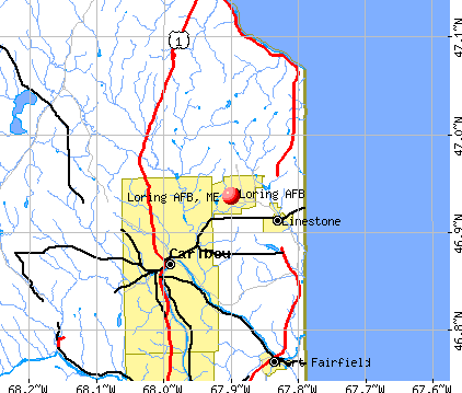
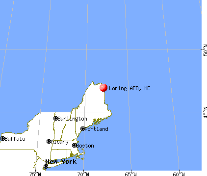
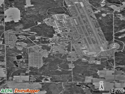
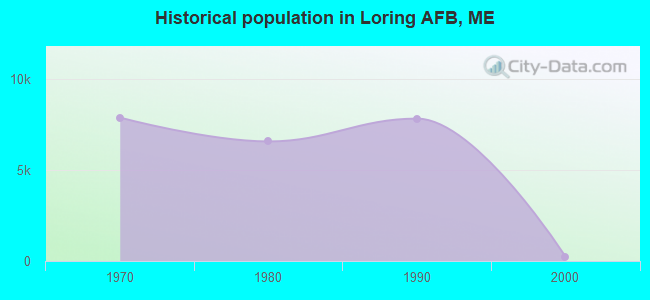
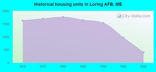
Loring AFB, Maine
Submit your own pictures of this place and show them to the world
- OSM Map
- General Map
- Google Map
- MSN Map
| Males: 104 | |
| Females: 115 |
| Median resident age: | 28.6 years |
| Maine median age: | 38.6 years |
Zip codes: 04750.
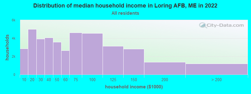
| Loring AFB: | $65,350 |
| ME: | $69,543 |
Estimated per capita income in 2022: $41,045 (it was $19,888 in 2000)
Loring AFB CDP income, earnings, and wages data
Estimated median house or condo value in 2022: $24,210 (it was $9,999 in 2000)
| Loring AFB: | $24,210 |
| ME: | $290,600 |
Mean prices in 2022: all housing units: $179,108; detached houses: $185,023; townhouses or other attached units: $218,327; in 2-unit structures: $262,505; in 3-to-4-unit structures: $121,406; in 5-or-more-unit structures: $185,084; mobile homes: $117,009; occupied boats, rvs, vans, etc.: $12,682
Compare current foreclosures near Loring AFB, ME:
| Photo | Address | Area | Beds / Baths | Price | Details |
|---|---|---|---|---|---|

|
#1
Limestone Rd
Fort Fairfield, ME 04742
|
780 sq. feet
|
1 baths 3 beds |
show details | |

|
#2
Limestone Rd
Fort Fairfield, ME 04742
|
972 sq. feet
|
2 baths 3 beds |
show details | |

|
#3
Dorsey Rd
Fort Fairfield, ME 04742
|
1,344 sq. feet
|
1 baths 3 beds |
show details | |

|
#4
Columbia Ave
Fort Fairfield, ME 04742
|
1,612 sq. feet
|
1 baths 3 beds |
show details | |

|
#5
Washburn Rd
Washburn, ME 04786
|
1,200 sq. feet
|
1 baths 3 beds |
show details | |

|
#6
Mcmanus St
Washburn, ME 04786
|
1,430 sq. feet
|
1 baths 3 beds |
show details | |

|
#7
S Park St
Caribou, ME 04736
|
1,684 sq. feet
|
2 baths 3 beds |
show details | |

|
#8
Glendale Rd
Caribou, ME 04736
|
940 sq. feet
|
1 baths 3 beds |
show details | |

|
#9
Belanger Rd
Caribou, ME 04736
|
1,268 sq. feet
|
1 baths 3 beds |
show details | |

|
#10
Washburn St
Caribou, ME 04736
|
1,739 sq. feet
|
2 baths 3 beds |
show details |
| Photo | Address | Area | Beds / Baths | Price | Details |
|---|---|---|---|---|---|

|
#11
Washburn St
Caribou, ME 04736
|
1,890 sq. feet
|
4 baths - beds |
show details | |

|
#12
Center Limestone Rd
Fort Fairfield, ME 04742
|
- sq. feet
|
- baths - beds |
show details | |

|
#13
Sweden St
Caribou, ME 04736
|
- sq. feet
|
- baths - beds |
show details | |

|
#14
Carson Rd
Caribou, ME 04736
|
- sq. feet
|
- baths - beds |
show details | |

|
#15
Huggard Ave
Limestone, ME 04750
|
- sq. feet
|
- baths - beds |
show details | |

|
#16
N Wade Rd
Washburn, ME 04786
|
- sq. feet
|
- baths - beds |
show details | |

|
#17
Champlain St
Van Buren, ME 04785
|
- sq. feet
|
- baths - beds |
show details | |

|
#18
Access Hwy
Limestone, ME 04750
|
- sq. feet
|
- baths - beds |
show details | |

|
#19
Lincoln St
Van Buren, ME 04785
|
- sq. feet
|
- baths - beds |
show details | |

|
#20
Nutting Rd
Perham, ME 04766
|
- sq. feet
|
- baths - beds |
show details |
| Photo | Address | Area | Beds / Baths | Price | Details |
|---|---|---|---|---|---|

|
#21
Sam Everett Rd
Fort Fairfield, ME 04742
|
- sq. feet
|
- baths - beds |
show details | |

|
#22
Bog Rd
Limestone, ME 04750
|
- sq. feet
|
- baths - beds |
show details | |

|
#23
State Rd
Mapleton, ME 04757
|
- sq. feet
|
- baths - beds |
show details | |

|
Check over 1 million property listings on Foreclosure.com!
|
browse all offers | |||

- 16472.9%White alone
- 3113.8%Hispanic
- 2310.2%Black alone
- 52.2%Asian alone
- 20.9%Two or more races
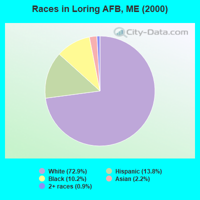
Races in Loring AFB detailed stats: ancestries, foreign born residents, place of birth
 Recent articles from our blog. Our writers, many of them Ph.D. graduates or candidates, create easy-to-read articles on a wide variety of topics.

 | Loring AFB in Maine 1966 Rutledge Family (0 replies) |
| Crossing the U.S./Maine Border (52 replies) |
| Loring AFB, has it been officially cleaned out? (42 replies) |
| Best areas to live in Maine! (24 replies) |
| African-American artist looking to possibly relocate to Maine (21 replies) |
| Charter schools in Maine?? (83 replies) |
Latest news from Loring AFB, ME collected exclusively by city-data.com from local newspapers, TV, and radio stations
Ancestries: Irish (14.7%), United States (11.1%), German (8.4%), French Canadian (5.8%), English (4.9%), Dutch (4.0%).
Current Local Time: EST time zone
Land area: 8.21 square miles.
Population density: 27 people per square mile (very low).
17 residents are foreign born (5.8% North America, 1.8% Africa).
| This place: | 7.6% |
| Maine: | 2.9% |
| Loring AFB CDP: | 0.0% ($0) |
| Maine: | 1.5% ($1,417) |
Nearest city with pop. 50,000+: Portland, ME  (253.9 miles , pop. 64,249).
Nearest city with pop. 200,000+: Boston, MA (355.7 miles , pop. 589,141).
Nearest city with pop. 1,000,000+: Bronx, NY (515.5 miles , pop. 1,332,650).
Nearest cities:
), ), ), ), ), ), Latitude: 46.94 N, Longitude: 67.90 W
Area code commonly used in this area: 207
| Here: | 4.8% |
| Maine: | 3.4% |
Average climate in Loring AFB, Maine
Based on data reported by over 4,000 weather stations


(lower is better)
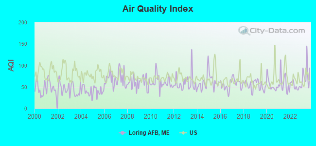
Air Quality Index (AQI) level in 2023 was 79.3. This is about average.
| City: | 79.3 |
| U.S.: | 72.6 |
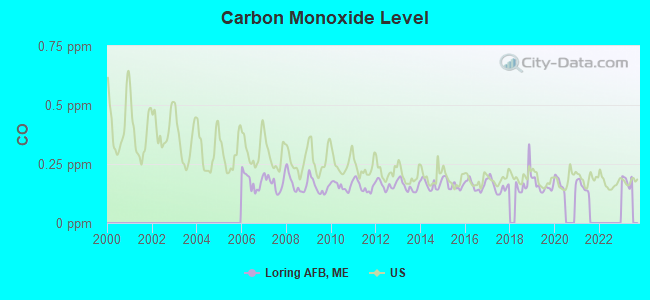
Carbon Monoxide (CO) [ppm] level in 2021 was 0.155. This is significantly better than average. Closest monitor was 17.8 miles away from the city center.
| City: | 0.155 |
| U.S.: | 0.251 |
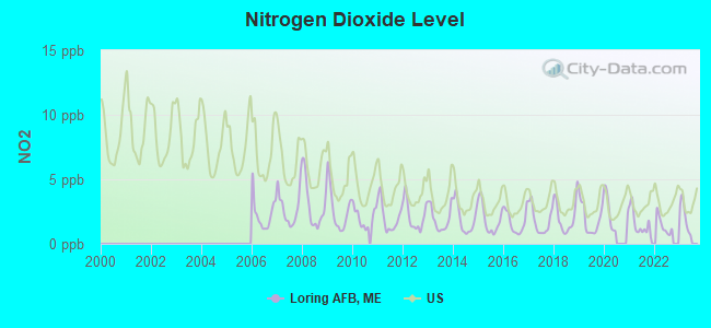
Nitrogen Dioxide (NO2) [ppb] level in 2022 was 1.41. This is significantly better than average. Closest monitor was 17.8 miles away from the city center.
| City: | 1.41 |
| U.S.: | 5.11 |
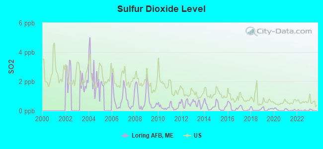
Sulfur Dioxide (SO2) [ppb] level in 2022 was 0.0234. This is significantly better than average. Closest monitor was 17.8 miles away from the city center.
| City: | 0.0234 |
| U.S.: | 1.5147 |
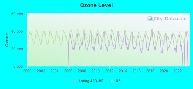
Ozone [ppb] level in 2022 was 27.2. This is better than average. Closest monitor was 7.2 miles away from the city center.
| City: | 27.2 |
| U.S.: | 33.3 |
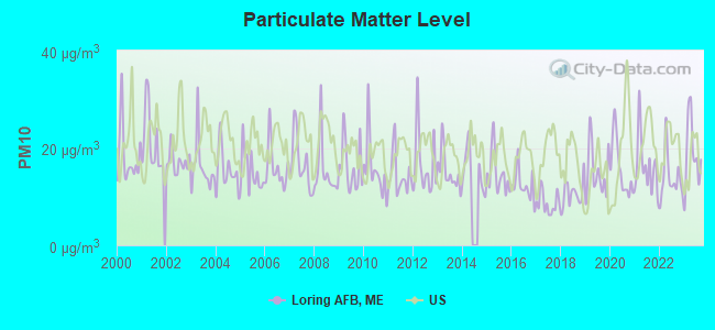
Particulate Matter (PM10) [µg/m3] level in 2023 was 19.0. This is about average. Closest monitor was 15.1 miles away from the city center.
| City: | 19.0 |
| U.S.: | 19.2 |
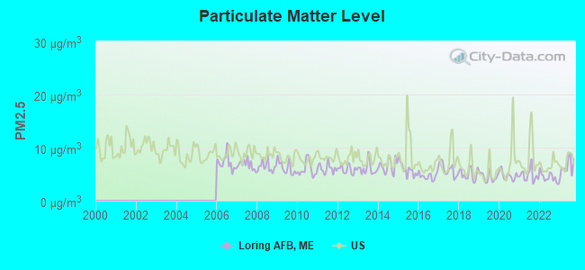
Particulate Matter (PM2.5) [µg/m3] level in 2023 was 6.41. This is better than average. Closest monitor was 17.7 miles away from the city center.
| City: | 6.41 |
| U.S.: | 8.11 |
Earthquake activity:
Loring AFB-area historical earthquake activity is above Maine state average. It is 88% smaller than the overall U.S. average.On 7/14/2006 at 09:34:48, a magnitude 3.9 (3.9 MD, Depth: 8.6 mi, Class: Light, Intensity: II - III) earthquake occurred 37.4 miles away from the city center
On 4/20/2002 at 10:50:47, a magnitude 5.3 (5.3 ML, Depth: 3.0 mi, Class: Moderate, Intensity: VI - VII) earthquake occurred 326.2 miles away from the city center
On 4/20/2002 at 10:50:47, a magnitude 5.2 (5.2 MB, 4.2 MS, 5.2 MW, 5.0 MW) earthquake occurred 328.0 miles away from Loring AFB center
On 10/16/2012 at 23:12:25, a magnitude 4.7 (4.7 ML, Depth: 10.0 mi, Class: Light, Intensity: IV - V) earthquake occurred 267.1 miles away from the city center
On 10/7/1983 at 10:18:46, a magnitude 5.3 (5.1 MB, 5.3 LG, 5.1 ML) earthquake occurred 374.4 miles away from Loring AFB center
On 1/19/1982 at 00:14:42, a magnitude 4.7 (4.5 MB, 4.7 MD, 4.5 LG) earthquake occurred 298.3 miles away from Loring AFB center
Magnitude types: regional Lg-wave magnitude (LG), body-wave magnitude (MB), duration magnitude (MD), local magnitude (ML), surface-wave magnitude (MS), moment magnitude (MW)
Natural disasters:
The number of natural disasters in Aroostook County (22) is greater than the US average (15).Major Disasters (Presidential) Declared: 13
Emergencies Declared: 9
Causes of natural disasters: Floods: 10, Storms: 8, Snows: 7, Heavy Rains: 2, Blizzard: 1, Hurricane: 1, Ice Storm: 1, Snowfall: 1, Snowstorm: 1, Wind: 1, Winter Storm: 1, Other: 2 (Note: some incidents may be assigned to more than one category).
Hospitals and medical centers near Loring AFB:
- VISITING NURSES OF AROOSTOOK (Home Health Center, about 7 miles away; CARIBOU, ME)
- CARY MEDICAL CENTER Acute Care Hospitals (about 7 miles away; CARIBOU, ME)
- MAINE VETERANS HOME - CARIBOU (Nursing Home, about 7 miles away; CARIBOU, ME)
- CARIBOU REHAB AND NURSING CENTER (Nursing Home, about 7 miles away; CARIBOU, ME)
- PROFESSIONAL HOME NURSING INC (Home Health Center, about 8 miles away; CARIBOU, ME)
- VALLEY HOME HEALTH SERVICES (Home Health Center, about 8 miles away; CARIBOU, ME)
- BORDERVIEW REHAB AND LIVING CTR (Nursing Home, about 15 miles away; VAN BUREN, ME)
Colleges/universities with over 2000 students nearest to Loring AFB:
- University of Maine (about 146 miles; Orono, ME; Full-time enrollment: 8,931)
- Husson University (about 152 miles; Bangor, ME; FT enrollment: 2,421)
- University of Maine at Farmington (about 191 miles; Farmington, ME; FT enrollment: 2,036)
- University of Maine at Augusta (about 202 miles; Augusta, ME; FT enrollment: 3,204)
- Saint Joseph's College of Maine (about 250 miles; Standish, ME; FT enrollment: 2,010)
- Southern Maine Community College (about 255 miles; South Portland, ME; FT enrollment: 4,666)
- University of Southern Maine (about 255 miles; Portland, ME; FT enrollment: 6,647)
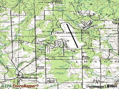
Points of interest:
Reservoir: Malabeam Lake (A). Display/hide its location on the map
| This place: | 2.7 people |
| Maine: | 2.4 people |
| This place: | 70.7% |
| Whole state: | 66.1% |
| This place: | 3.7% |
| Whole state: | 7.3% |
No gay or lesbian households reported
| This place: | 5.0% |
| Whole state: | 10.9% |
For population 15 years and over in Loring AFB:
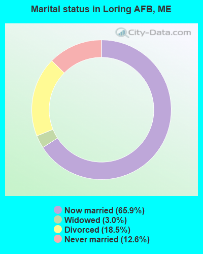
- Never married: 12.6%
- Now married: 65.9%
- Separated: 0.0%
- Widowed: 3.0%
- Divorced: 18.5%
For population 25 years and over in Loring AFB:
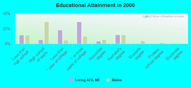
- High school or higher: 85.6%
- Bachelor's degree or higher: 15.3%
- Graduate or professional degree: 0.0%
- Unemployed: 8.9%
- Mean travel time to work (commute): 8.0 minutes
| Here: | 10.5 |
| Maine average: | 11.2 |


Graphs represent county-level data. Detailed 2008 Election Results
Religion statistics for Loring AFB, ME (based on Aroostook County data)


| Religion | Adherents | Congregations |
|---|---|---|
| Catholic | 22,200 | 27 |
| Mainline Protestant | 5,845 | 40 |
| Evangelical Protestant | 4,411 | 51 |
| Other | 957 | 7 |
| Orthodox | 10 | 1 |
| None | 38,447 | - |
Food Environment Statistics:
| This county: | 4.03 / 10,000 pop. |
| Maine: | 2.80 / 10,000 pop. |
| This county: | 0.14 / 10,000 pop. |
| Maine: | 0.14 / 10,000 pop. |
| Aroostook County: | 2.22 / 10,000 pop. |
| State: | 2.20 / 10,000 pop. |
| Here: | 7.78 / 10,000 pop. |
| Maine: | 5.75 / 10,000 pop. |
| This county: | 9.17 / 10,000 pop. |
| Maine: | 11.02 / 10,000 pop. |
| This county: | 11.7% |
| Maine: | 8.2% |
| This county: | 27.6% |
| Maine: | 25.0% |
Strongest AM radio stations in Loring AFB:
- WFST (600 AM; 5 kW; CARIBOU, ME; Owner: NORTHERN BROADCAST MINISTRIES, INC.)
- WEGP (1390 AM; 5 kW; PRESQUE ISLE, ME; Owner: DECELLES/SMITH MEDIA, INC.)
- WREM (710 AM; daytime; 5 kW; MONTICELLO, ME; Owner: ALLAN H WEINER)
- WRKO (680 AM; 50 kW; BOSTON, MA; Owner: ENTERCOM BOSTON LICENSE, LLC)
- WCHP (760 AM; 35 kW; CHAMPLAIN, NY; Owner: CHAMPLAIN RADIO, INC.)
- WNNZ (640 AM; 50 kW; WESTFIELD, MA; Owner: CLEAR CHANNEL BROADCASTING LICENSES, INC.)
- WEEI (850 AM; 50 kW; BOSTON, MA; Owner: ENTERCOM BOSTON LICENSE, LLC)
- WCRN (830 AM; 50 kW; WORCESTER, MA; Owner: CARTER BROADCASTING CORPORATION)
- WBZ (1030 AM; 50 kW; BOSTON, MA; Owner: INFINITY BROADCASTING OPERATIONS, INC.)
- WGY (810 AM; 50 kW; SCHENECTADY, NY; Owner: CLEAR CHANNEL BROADCASTING LICENSES, INC.)
- WALE (990 AM; 50 kW; GREENVILLE, RI; Owner: NORTH AMERICAN BROADCASTING CO., INC.)
- WZON (620 AM; 5 kW; BANGOR, ME; Owner: THE ZONE CORPORATION)
- WKOX (1200 AM; 50 kW; FRAMINGHAM, MA; Owner: CAPSTAR TX LIMITED PARTNERSHIP)
Strongest FM radio stations in Loring AFB:
- WBPW (96.9 FM; PRESQUE ISLE, ME; Owner: CITADEL BROADCASTING COMPANY)
- WQHR (96.1 FM; PRESQUE ISLE, ME; Owner: CITADEL BROADCASTING COMPANY)
- WCXU (97.7 FM; CARIBOU, ME; Owner: THE CANXUS BROADCASTING CORPORATION)
- WOZI (101.9 FM; PRESQUE ISLE, ME; Owner: CITADEL BROADCASTING COMPANY)
- WMEM (106.1 FM; PRESQUE ISLE, ME; Owner: MAINE PUBLIC BROADCASTING CORPORATION)
- W274AF (102.7 FM; PRESQUE ISLE, ME; Owner: BANGOR BAPTIST CHURCH)
FCC Registered Amateur Radio Licenses:
1- Call Sign: KB9IDR, Grant Date: 12/29/1992, Expiration Date: 12/29/2002, Cancellation Date: 12/30/2004, Registrant: Michael A Smith Jr, 6350 Kentucky Rd Rm 339a, Loring Afb, ME 04751
Loring AFB compared to Maine state average:
- Median house value significantly below state average.
- Black race population percentage significantly above state average.
- Hispanic race population percentage significantly above state average.
- Median age significantly below state average.
- Foreign-born population percentage above state average.
- Renting percentage significantly below state average.
- Length of stay since moving in significantly above state average.
- Number of rooms per house significantly below state average.
- House age significantly below state average.
- Percentage of population with a bachelor's degree or higher below state average.
Loring AFB on our top lists:
- #25 on the list of "Top 100 cities with lowest ratio of median house value to median household income"
- #99 on the list of "Top 100 cities with shortest commuting times"
- #19 on the list of "Top 101 counties with the highest carbon monoxide air pollution readings in 2012 (ppm)"
- #22 on the list of "Top 101 counties with the smallest number of children under 18 without health insurance coverage in 2000 (pop. 50,000+)"
- #29 on the list of "Top 101 counties with the lowest percentage of residents relocating from other counties between 2010 and 2011"
- #34 on the list of "Top 101 counties with the lowest percentage of residents relocating to other counties in 2011"
- #46 on the list of "Top 101 counties with the lowest Particulate Matter (PM2.5) Annual air pollution readings in 2012 (µg/m3)"