North Treasure, Montana
Submit your own pictures of this place and show them to the world
- OSM Map
- General Map
- Google Map
- MSN Map

| Males: 117 | |
| Females: 106 |
| Median resident age: | 38.8 years |
| Montana median age: | 37.5 years |
Zip code: 59038
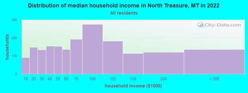
| North Treasure: | $62,883 |
| MT: | $67,631 |
Estimated per capita income in 2022: $26,086 (it was $9,923 in 2000)
North Treasure CCD income, earnings, and wages data
Estimated median house or condo value in 2022: $402,394 (it was $72,500 in 2000)
| North Treasure: | $402,394 |
| MT: | $366,400 |
Mean prices in 2022: all housing units: $302,006; detached houses: $323,179; mobile homes: $133,440
North Treasure, MT residents, houses, and apartments details
Detailed information about poverty and poor residents in North Treasure, MT


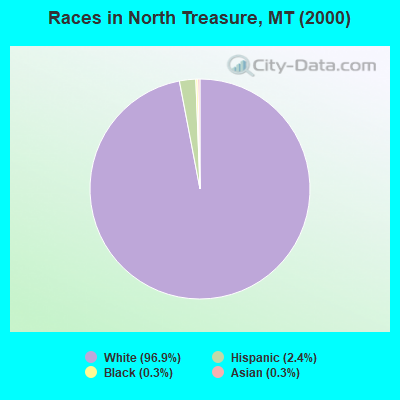
- 28396.9%White alone
- 72.4%Hispanic
- 10.3%Black alone
- 10.3%Asian alone
Races in North Treasure detailed stats: ancestries, foreign born residents, place of birth
 Recent articles from our blog. Our writers, many of them Ph.D. graduates or candidates, create easy-to-read articles on a wide variety of topics.
Current Local Time: MST time zone
Land area: 474.3 square miles.
Population density: 0.5 people per square mile (very low).

| North Treasure CCD: | 0.7% ($500) |
| Montana: | 1.3% ($1,212) |
Nearest city with pop. 50,000+: Billings, MT  (65.8 miles , pop. 89,847).
Nearest city with pop. 200,000+: West Adams, CO (461.3 miles , pop. 259,628).
Nearest city with pop. 1,000,000+: Phoenix, AZ (917.8 miles , pop. 1,321,045).
Nearest cities:
), ), ), Latitude: 46.31 N, Longitude: 107.39 W
Area code commonly used in this area: 406

| Here: | 2.9% |
| Montana: | 3.8% |
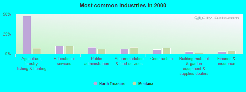
- Agriculture, forestry, fishing & hunting (47.7%)
- Educational services (9.9%)
- Public administration (7.9%)
- Accommodation & food services (6.0%)
- Construction (5.3%)
- Building material & garden equipment & supplies dealers (2.6%)
- Finance & insurance (2.6%)
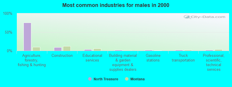
- Agriculture, forestry, fishing & hunting (75.0%)
- Construction (9.5%)
- Educational services (3.6%)
- Building material & garden equipment & supplies dealers (2.4%)
- Gasoline stations (2.4%)
- Truck transportation (2.4%)
- Professional, scientific, technical services (2.4%)
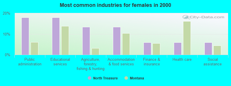
- Public administration (17.9%)
- Educational services (17.9%)
- Agriculture, forestry, fishing & hunting (13.4%)
- Accommodation & food services (13.4%)
- Finance & insurance (6.0%)
- Health care (6.0%)
- Social assistance (6.0%)
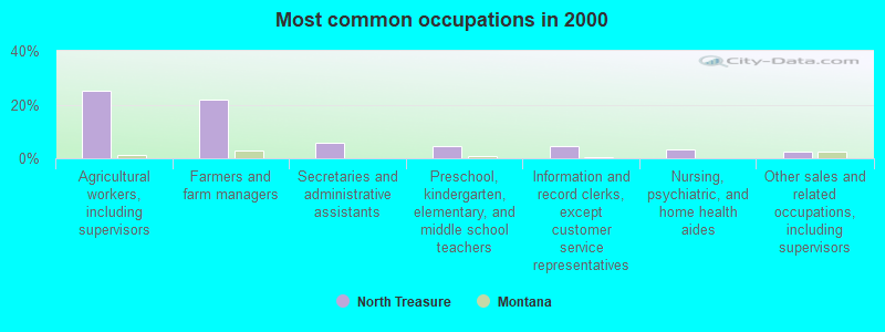
- Agricultural workers, including supervisors (25.2%)
- Farmers and farm managers (21.9%)
- Secretaries and administrative assistants (6.0%)
- Preschool, kindergarten, elementary, and middle school teachers (4.6%)
- Information and record clerks, except customer service representatives (4.6%)
- Nursing, psychiatric, and home health aides (3.3%)
- Other sales and related occupations, including supervisors (2.6%)
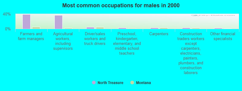
- Farmers and farm managers (39.3%)
- Agricultural workers, including supervisors (36.9%)
- Driver/sales workers and truck drivers (4.8%)
- Preschool, kindergarten, elementary, and middle school teachers (3.6%)
- Carpenters (3.6%)
- Construction traders workers except carpenters, electricians, painters, plumbers, and construction laborers (3.6%)
- Other financial specialists (2.4%)
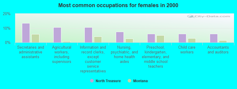
- Secretaries and administrative assistants (13.4%)
- Agricultural workers, including supervisors (10.4%)
- Information and record clerks, except customer service representatives (10.4%)
- Nursing, psychiatric, and home health aides (7.5%)
- Preschool, kindergarten, elementary, and middle school teachers (6.0%)
- Child care workers (6.0%)
- Accountants and auditors (6.0%)
Average climate in North Treasure, Montana
Based on data reported by over 4,000 weather stations


Earthquake activity:
North Treasure-area historical earthquake activity is significantly above Montana state average. It is 478% greater than the overall U.S. average.On 8/18/1959 at 06:37:13, a magnitude 7.7 (7.7 UK, Class: Major, Intensity: VIII - XII) earthquake occurred 199.0 miles away from North Treasure center, causing $26,000,000 total damage
On 10/28/1983 at 14:06:06, a magnitude 7.3 (6.2 MB, 7.3 MS, 7.0 MW) earthquake occurred 348.3 miles away from the city center, causing 2 deaths (2 shaking deaths) and 3 injuries, causing $15,000,000 total damage
On 6/30/1975 at 18:54:13, a magnitude 6.1 (5.6 MB, 5.9 MS, 6.1 UK, 6.1 ML, Class: Strong, Intensity: VII - IX) earthquake occurred 197.7 miles away from the city center
On 7/6/2017 at 06:30:17, a magnitude 5.8 (5.8 MW, Depth: 7.6 mi, Class: Moderate, Intensity: VI - VII) earthquake occurred 249.4 miles away from North Treasure center
On 3/31/2020 at 23:52:30, a magnitude 6.5 (6.5 MW, Depth: 7.5 mi) earthquake occurred 396.1 miles away from North Treasure center
On 7/26/2005 at 04:08:37, a magnitude 5.7 (5.7 MB, 5.2 MS, 5.6 MW) earthquake occurred 257.4 miles away from North Treasure center
Magnitude types: body-wave magnitude (MB), local magnitude (ML), surface-wave magnitude (MS), moment magnitude (MW)
Natural disasters:
The number of natural disasters in Treasure County (8) is smaller than the US average (15).Major Disasters (Presidential) Declared: 4
Emergencies Declared: 1
Causes of natural disasters: Floods: 5, Storms: 3, Fire: 1, Hurricane: 1, Snow: 1, Other: 1 (Note: some incidents may be assigned to more than one category).
Colleges/universities with over 2000 students nearest to North Treasure:
- Montana State University-Billings (about 65 miles; Billings, MT; Full-time enrollment: 4,319)
- Sheridan College (about 110 miles; Sheridan, WY; FT enrollment: 2,070)
- Montana State University (about 182 miles; Bozeman, MT; FT enrollment: 12,942)
- Black Hills State University (about 213 miles; Spearfish, SD; FT enrollment: 3,166)
- Casper College (about 247 miles; Casper, WY; FT enrollment: 2,770)
- South Dakota School of Mines and Technology (about 256 miles; Rapid City, SD; FT enrollment: 2,102)
- Brigham Young University-Idaho (about 276 miles; Rexburg, ID; FT enrollment: 30,522)
Points of interest:
Notable locations in North Treasure: Big Horn (A), Hysham (B), Sarpy Junction (C), Eldering Ranch (D), Myers Bridge Fishing Access Site (E), Stacy Island Fishing Access Site (F), Amelia Island Fishing Access Site (G), Fort Pease (H), Steie Ranch (I), Myers Siding (J). Display/hide their locations on the map
Church in North Treasure: Rancher Church (A). Display/hide its location on the map
Cemeteries: Memorial Vale Cemetery (1), Rancher Cemetery (2). Display/hide their locations on the map
Reservoirs: Horton Reservoir (A), Teds Reservoir (B), Larsens Reservoir (C). Display/hide their locations on the map
Creeks: Cowen Creek (A), Alkali Creek (B), Allen Creek (C), Box Elder Creek (D), Butte Creek (E), Cutoff Creek (F), Edwards Creek (G), Forty-five Creek (H), Forty-four Creek (I). Display/hide their locations on the map
| This place: | 2.2 people |
| Montana: | 2.4 people |
| This place: | 68.3% |
| Whole state: | 62.8% |
| This place: | 4.8% |
| Whole state: | 6.7% |
No gay or lesbian households reported
| This place: | 19.0% |
| Whole state: | 14.6% |
| This place: | 5.7% |
| Whole state: | 5.8% |
For population 15 years and over in North Treasure:
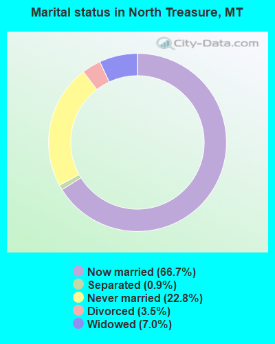
- Never married: 22.8%
- Now married: 66.7%
- Separated: 0.9%
- Widowed: 7.0%
- Divorced: 3.5%
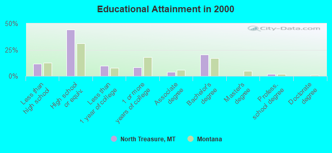
For population 25 years and over in North Treasure:
- High school or higher: 88.2%
- Bachelor's degree or higher: 22.5%
- Graduate or professional degree: 2.1%
- Unemployed: 1.3%
- Mean travel time to work (commute): 12.1 minutes
| Here: | 7.8 |
| Montana average: | 10.4 |
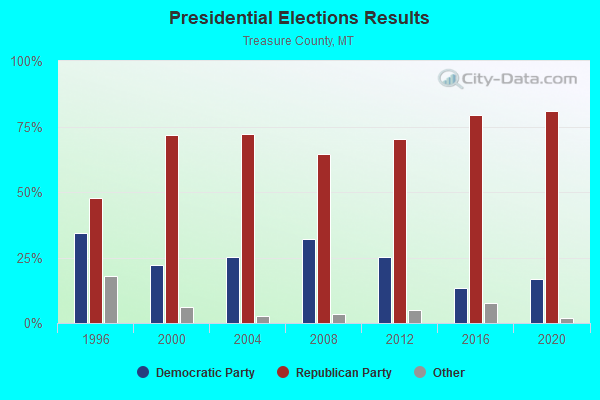
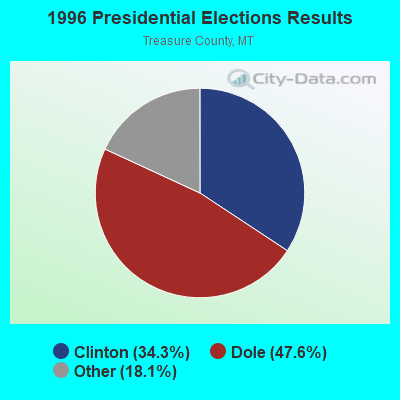
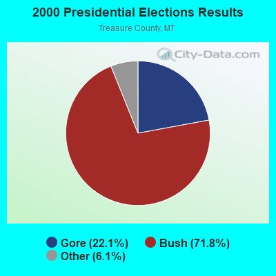
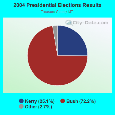
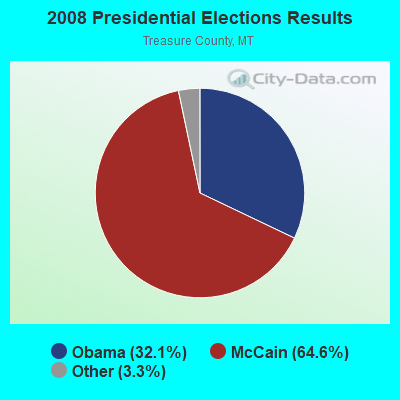
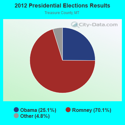
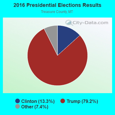
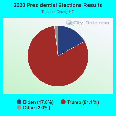
Graphs represent county-level data. Detailed 2008 Election Results
Religion statistics for North Treasure, MT (based on Treasure County data)
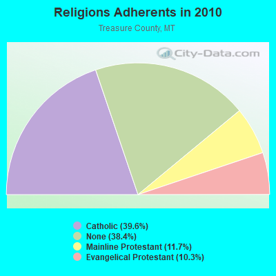
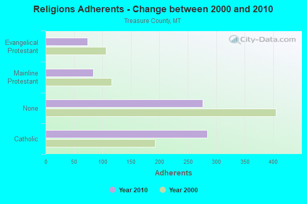
| Religion | Adherents | Congregations |
|---|---|---|
| Catholic | 284 | 1 |
| Mainline Protestant | 84 | 1 |
| Evangelical Protestant | 74 | 2 |
| None | 276 | - |
Food Environment Statistics:
| Treasure County: | 15.43 / 10,000 pop. |
| Montana: | 2.55 / 10,000 pop. |
| Treasure County: | 15.43 / 10,000 pop. |
| State: | 4.69 / 10,000 pop. |
| Treasure County: | 15.43 / 10,000 pop. |
| Montana: | 10.38 / 10,000 pop. |
| Here: | 7.7% |
| Montana: | 7.2% |
| Treasure County: | 23.5% |
| Montana: | 23.1% |
Strongest AM radio stations in North Treasure:
- KIKC (1250 AM; 5 kW; FORSYTH, MT; Owner: MILES CITY, FORSYTH B/DCSTG, INC.)
- KATL (770 AM; 10 kW; MILES CITY, MT; Owner: STAR PRINTING COMPANY)
- KMTA (1050 AM; 10 kW; MILES CITY, MT; Owner: SENGER BROADCASTING CORPORATION)
- KURL (730 AM; 5 kW; BILLINGS, MT; Owner: ELENBAAS MEDIA, INC.)
- KGHL (790 AM; 5 kW; BILLINGS, MT; Owner: NEW NORTHWEST BROADCASTERS, LLC)
- KBUL (970 AM; 5 kW; BILLINGS, MT; Owner: CAPSTAR TX LIMITED PARTNERSHIP)
- KTWO (1030 AM; 50 kW; CASPER, WY; Owner: CITICASTERS LICENSES, L.P.)
- KXMR (710 AM; 50 kW; BISMARCK, ND; Owner: RADIO BISMARCK MANDAN, LLC)
- KERR (750 AM; 50 kW; POLSON, MT; Owner: ANDERSON RADIO BROADCASTING, INC.)
- KBHB (810 AM; 25 kW; STURGIS, SD; Owner: MONTEREY LICENSES, LLC)
- KZMQ (1140 AM; daytime; 10 kW; GREYBULL, WY; Owner: LEGEND COMMUNICATIONS OF WYOMING LLC)
- KUYO (830 AM; daytime; 25 kW; EVANSVILLE, WY; Owner: WYOMING CHRISTIAN BROADCASTING COMPANY)
- KROE (930 AM; 5 kW; SHERIDAN, WY; Owner: LOVCOM, INC.)
Strongest FM radio stations in North Treasure:
- KMHK (95.5 FM; HARDIN, MT; Owner: CAPSTAR TX LIMITED PARTNERSHIP)
TV broadcast stations around North Treasure:
- K11OS (Channel 11; HYSHAM, MT; Owner: TREASURE COUNTY T.V. DISTRICT)
- K13PO (Channel 13; HYSHAM, MT; Owner: TREASURE COUNTY T.V. DISTRICT)
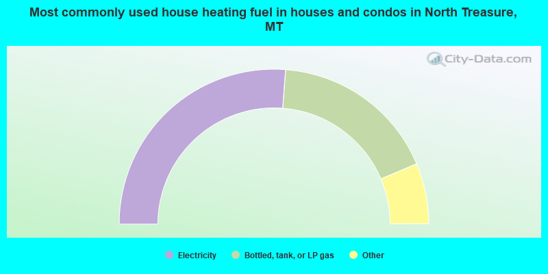
- 52.4%Electricity
- 34.9%Bottled, tank, or LP gas
- 3.2%Fuel oil, kerosene, etc.
- 3.2%Coal or coke
- 3.2%Wood
- 3.2%No fuel used
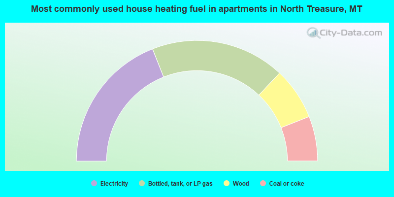
- 38.0%Electricity
- 36.0%Bottled, tank, or LP gas
- 14.0%Wood
- 12.0%Coal or coke
North Treasure compared to Montana state average:
- Unemployed percentage significantly below state average.
- Hispanic race population percentage below state average.
- Foreign-born population percentage significantly below state average.
- Length of stay since moving in significantly above state average.
- Number of rooms per house significantly below state average.
- House age significantly below state average.
- Number of college students significantly below state average.