North of the Yellowstone, Montana
Submit your own pictures of this place and show them to the world
- OSM Map
- General Map
- Google Map
- MSN Map

| Males: 1,325 | |
| Females: 1,326 |
| Median resident age: | 42.9 years |
| Montana median age: | 37.5 years |
Zip code: 59011
| North of the Yellowstone: | $57,582 |
| MT: | $67,631 |
Estimated per capita income in 2022: $33,607 (it was $18,033 in 2000)
North of the Yellowstone CCD income, earnings, and wages data
Estimated median house or condo value in 2022: $200,221 (it was $58,400 in 2000)
| North of the Yellowstone: | $200,221 |
| MT: | $366,400 |
Mean prices in 2022: all housing units: $224,715; detached houses: $253,091; townhouses or other attached units: $209,103; mobile homes: $79,717
North of the Yellowstone, MT residents, houses, and apartments details
Detailed information about poverty and poor residents in North of the Yellowstone, MT
Compare current foreclosures near North of the Yellowstone, MT:


- 2,58794.8%White alone
- 451.6%American Indian alone
- 381.4%Hispanic
- 311.1%Two or more races
- 190.7%Asian alone
- 40.1%Black alone
- 40.1%Other race alone

Races in North of the Yellowstone detailed stats: ancestries, foreign born residents, place of birth
 Recent articles from our blog. Our writers, many of them Ph.D. graduates or candidates, create easy-to-read articles on a wide variety of topics.
Current Local Time: MST time zone
Land area: 2682.5 square miles.
Population density: 1.0 people per square mile (very low).

| North of the Yellowstone CCD: | 1.3% ($768) |
| Montana: | 1.3% ($1,212) |
Nearest city with pop. 50,000+: Billings, MT  (95.7 miles , pop. 89,847).
Nearest city with pop. 200,000+: West Adams, CO (475.6 miles , pop. 259,628).
Nearest city with pop. 1,000,000+: Phoenix, AZ (944.2 miles , pop. 1,321,045).
Nearest cities:
), ), ), Latitude: 46.61 N, Longitude: 106.93 W
Area code commonly used in this area: 406


| Here: | 4.4% |
| Montana: | 3.8% |

- Agriculture, forestry, fishing & hunting (12.9%)
- Accommodation & food services (12.2%)
- Health care (10.9%)
- Educational services (7.8%)
- Public administration (6.2%)
- Rail transportation (5.5%)
- Construction (5.1%)

- Agriculture, forestry, fishing & hunting (17.6%)
- Rail transportation (9.3%)
- Mining, quarrying, oil & gas extraction (9.1%)
- Construction (9.0%)
- Utilities (6.5%)
- Public administration (5.3%)
- Health care (4.8%)

- Accommodation & food services (20.6%)
- Health care (17.8%)
- Educational services (12.0%)
- Agriculture, forestry, fishing & hunting (7.4%)
- Public administration (7.2%)
- Food & beverage stores (6.2%)
- Finance & insurance (4.2%)

- Farmers and farm managers (6.4%)
- Other management occupations, except farmers and farm managers (4.8%)
- Building and grounds cleaning and maintenance occupations (4.7%)
- Cooks and food preparation workers (4.6%)
- Agricultural workers, including supervisors (4.5%)
- Preschool, kindergarten, elementary, and middle school teachers (3.5%)
- Rail and water transportation workers (3.5%)

- Farmers and farm managers (9.8%)
- Rail and water transportation workers (6.5%)
- Agricultural workers, including supervisors (6.5%)
- Extraction workers (5.0%)
- Metal workers and plastic workers (4.5%)
- Vehicle and mobile equipment mechanics, installers, and repairers (4.3%)
- Other sales and related occupations, including supervisors (4.0%)

- Cooks and food preparation workers (7.2%)
- Other management occupations, except farmers and farm managers (6.2%)
- Building and grounds cleaning and maintenance occupations (6.2%)
- Preschool, kindergarten, elementary, and middle school teachers (5.5%)
- Food and beverage serving workers, except waiters and waitresses (5.5%)
- Secretaries and administrative assistants (5.3%)
- Nursing, psychiatric, and home health aides (4.2%)
Average climate in North of the Yellowstone, Montana
Based on data reported by over 4,000 weather stations


Earthquake activity:
North of the Yellowstone-area historical earthquake activity is significantly above Montana state average. It is 411% greater than the overall U.S. average.On 8/18/1959 at 06:37:13, a magnitude 7.7 (7.7 UK, Class: Major, Intensity: VIII - XII) earthquake occurred 229.0 miles away from the city center, causing $26,000,000 total damage
On 10/28/1983 at 14:06:06, a magnitude 7.3 (6.2 MB, 7.3 MS, 7.0 MW) earthquake occurred 377.1 miles away from the city center, causing 2 deaths (2 shaking deaths) and 3 injuries, causing $15,000,000 total damage
On 6/30/1975 at 18:54:13, a magnitude 6.1 (5.6 MB, 5.9 MS, 6.1 UK, 6.1 ML, Class: Strong, Intensity: VII - IX) earthquake occurred 227.6 miles away from the city center
On 7/6/2017 at 06:30:17, a magnitude 5.8 (5.8 MW, Depth: 7.6 mi, Class: Moderate, Intensity: VI - VII) earthquake occurred 268.4 miles away from North of the Yellowstone center
On 3/31/2020 at 23:52:30, a magnitude 6.5 (6.5 MW, Depth: 7.5 mi) earthquake occurred 423.3 miles away from the city center
On 7/26/2005 at 04:08:37, a magnitude 5.7 (5.7 MB, 5.2 MS, 5.6 MW) earthquake occurred 283.8 miles away from North of the Yellowstone center
Magnitude types: body-wave magnitude (MB), local magnitude (ML), surface-wave magnitude (MS), moment magnitude (MW)
Natural disasters:
The number of natural disasters in Rosebud County (10) is smaller than the US average (15).Major Disasters (Presidential) Declared: 7
Emergencies Declared: 1
Causes of natural disasters: Floods: 5, Fires: 3, Storms: 3, Hurricane: 1, Other: 1 (Note: some incidents may be assigned to more than one category).
Colleges/universities with over 2000 students nearest to North of the Yellowstone:
- Montana State University-Billings (about 95 miles; Billings, MT; Full-time enrollment: 4,319)
- Sheridan College (about 128 miles; Sheridan, WY; FT enrollment: 2,070)
- Black Hills State University (about 208 miles; Spearfish, SD; FT enrollment: 3,166)
- Montana State University (about 208 miles; Bozeman, MT; FT enrollment: 12,942)
- South Dakota School of Mines and Technology (about 252 miles; Rapid City, SD; FT enrollment: 2,102)
- Casper College (about 263 miles; Casper, WY; FT enrollment: 2,770)
- Minot State University (about 287 miles; Minot, ND; FT enrollment: 2,887)
Points of interest:
Notable locations in North of the Yellowstone: Aldinger Ranch (A), McDonald Ranch (B), Barley Ranch (C), Mardis Ranch (D), Blacktail Ranch (E), Brockel Homestead (F), Erickson Ranch (G), Finch Ranch (H), Fox Homestead (I), Zempel Ranch (J), Yablonski Ranch (K), Gray Ranch (L), Grebe Ranch (M), Flynn (N), Forsyth (O), Guthridge Ranch (P), Hagen Ranch (Q), Wagon Wheel Campground (R), Rosebud Campground (S), Hauck Ranch (T). Display/hide their locations on the map
Churches in North of the Yellowstone include: Federated Church (A), Assembly of God Church (B), First Baptist Church (C), Church of God (D), Concordia Lutheran Church (E), Immaculate Conception Church (F), Jehovah's Witnesses (G), Forsyth Wesleyan Church (H), The Church of Jesus Christ of Latter Day Saints (I). Display/hide their locations on the map
Cemeteries: Forsyth Cemetery (1), Vanstel Cemetery (2), Sumatra Cemetery (3). Display/hide their locations on the map
Reservoirs: Brown Coulee Reservoir (A), Boies Reservoir (B), Blacktail Reservoir (C), Black Sea Reservoir (D), Black Coulee Reservoir (E), Big Reservoir (F), Zempel Lake (G), Hay Creek Reservoir (H). Display/hide their locations on the map
Streams, rivers, and creeks: Big Breed Creek (A), Antelope Creek (B), Big Porcupine Creek (C), Blacktail Creek (D), Acorn Creek (E), Alkali Creek (F), Anderson Creek (G), Beaverball Creek (H), Bootjack Creek (I). Display/hide their locations on the map
Parks in North of the Yellowstone include: West Rosebud State Park (1), VFW Park (2), East Rosebud State Park (3), Rosebud River Historical Marker (4), Riverside Park (5), Pioneer Park (6), Marceys Park (7). Display/hide their locations on the map
| This place: | 2.3 people |
| Montana: | 2.4 people |
| This place: | 69.2% |
| Whole state: | 62.8% |
| This place: | 5.5% |
| Whole state: | 6.7% |
Likely homosexual households (counted as self-reported same-sex unmarried-partner households)
- Lesbian couples: 0.0% of all households
- Gay men: 0.4% of all households
| This place: | 12.7% |
| Whole state: | 14.6% |
| This place: | 4.9% |
| Whole state: | 5.8% |
24 people in local jails and other confinement facilities (including police lockups) in 2000
For population 15 years and over in North of the Yellowstone:

- Never married: 19.7%
- Now married: 62.8%
- Separated: 2.1%
- Widowed: 8.1%
- Divorced: 9.4%
For population 25 years and over in North of the Yellowstone:
- High school or higher: 83.7%
- Bachelor's degree or higher: 13.8%
- Graduate or professional degree: 4.3%
- Unemployed: 4.5%
- Mean travel time to work (commute): 18.6 minutes


| Here: | 9.5 |
| Montana average: | 10.4 |
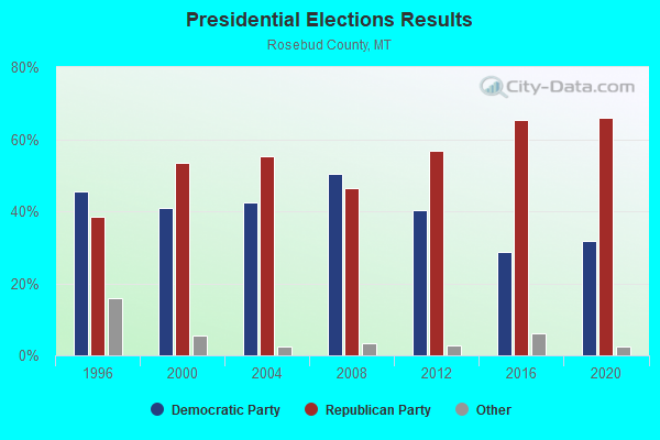
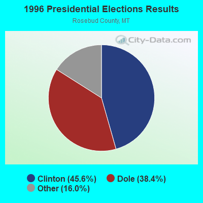
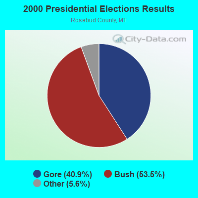
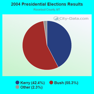
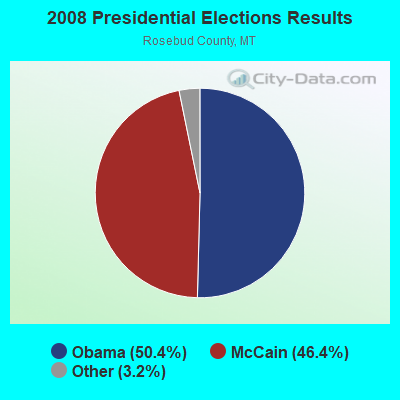
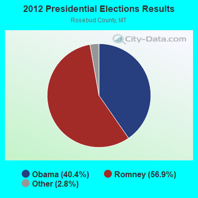
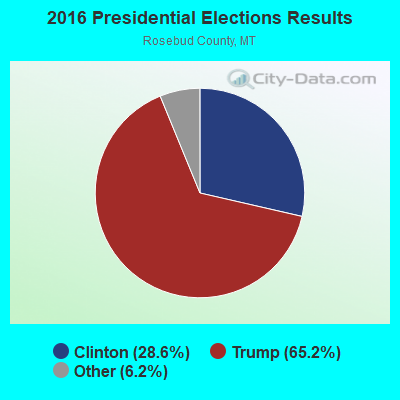
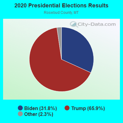
Graphs represent county-level data. Detailed 2008 Election Results
Religion statistics for North of the Yellowstone, MT (based on Rosebud County data)
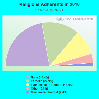
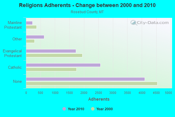
| Religion | Adherents | Congregations |
|---|---|---|
| Catholic | 2,573 | 4 |
| Evangelical Protestant | 1,719 | 19 |
| Other | 624 | 3 |
| Mainline Protestant | 218 | 4 |
| None | 4,099 | - |
Food Environment Statistics:
| This county: | 6.55 / 10,000 pop. |
| Montana: | 2.55 / 10,000 pop. |
| Rosebud County: | 4.37 / 10,000 pop. |
| Montana: | 4.69 / 10,000 pop. |
| Rosebud County: | 8.73 / 10,000 pop. |
| State: | 10.38 / 10,000 pop. |
| Rosebud County: | 9.5% |
| Montana: | 7.2% |
| Here: | 39.1% |
| State: | 23.1% |
| Rosebud County: | 19.5% |
| Montana: | 10.7% |
Strongest AM radio stations in North of the Yellowstone:
- KIKC (1250 AM; 5 kW; FORSYTH, MT; Owner: MILES CITY, FORSYTH B/DCSTG, INC.)
- KATL (770 AM; 10 kW; MILES CITY, MT; Owner: STAR PRINTING COMPANY)
- KMTA (1050 AM; 10 kW; MILES CITY, MT; Owner: SENGER BROADCASTING CORPORATION)
- KXMR (710 AM; 50 kW; BISMARCK, ND; Owner: RADIO BISMARCK MANDAN, LLC)
- KURL (730 AM; 5 kW; BILLINGS, MT; Owner: ELENBAAS MEDIA, INC.)
- KTWO (1030 AM; 50 kW; CASPER, WY; Owner: CITICASTERS LICENSES, L.P.)
- KGHL (790 AM; 5 kW; BILLINGS, MT; Owner: NEW NORTHWEST BROADCASTERS, LLC)
- KBHB (810 AM; 25 kW; STURGIS, SD; Owner: MONTEREY LICENSES, LLC)
- KERR (750 AM; 50 kW; POLSON, MT; Owner: ANDERSON RADIO BROADCASTING, INC.)
- KBUL (970 AM; 5 kW; BILLINGS, MT; Owner: CAPSTAR TX LIMITED PARTNERSHIP)
- KUYO (830 AM; daytime; 25 kW; EVANSVILLE, WY; Owner: WYOMING CHRISTIAN BROADCASTING COMPANY)
- KZMQ (1140 AM; daytime; 10 kW; GREYBULL, WY; Owner: LEGEND COMMUNICATIONS OF WYOMING LLC)
- KROE (930 AM; 5 kW; SHERIDAN, WY; Owner: LOVCOM, INC.)
Strongest FM radio stations in North of the Yellowstone:
- KIKC-FM (101.3 FM; FORSYTH, MT; Owner: MILES CITY, FORSYTH B/CSTG, INC.)

- 64.2%Utility gas
- 22.2%Bottled, tank, or LP gas
- 7.1%Electricity
- 4.1%Wood
- 1.5%Coal or coke
- 1.0%Fuel oil, kerosene, etc.

- 68.9%Utility gas
- 20.2%Electricity
- 9.4%Bottled, tank, or LP gas
- 1.5%Coal or coke
North of the Yellowstone compared to Montana state average:
- Median house value below state average.
- Unemployed percentage significantly below state average.
- Black race population percentage below state average.
- Hispanic race population percentage significantly below state average.
- Median age above state average.
- Foreign-born population percentage significantly below state average.
- Length of stay since moving in significantly above state average.
- Number of rooms per house significantly below state average.
- House age significantly below state average.
- Institutionalized population percentage significantly above state average.
- Number of college students significantly below state average.
- Percentage of population with a bachelor's degree or higher below state average.
North of the Yellowstone on our top lists:
- #31 on the list of "Top 100 cities with largest land areas"
- #36 on the list of "Top 101 counties with the lowest Nitrogen Dioxide air pollution readings in 2012 (ppm)"
- #61 on the list of "Top 101 counties with the highest Particulate Matter (PM10) Annual air pollution readings in 2012 (µg/m3)"