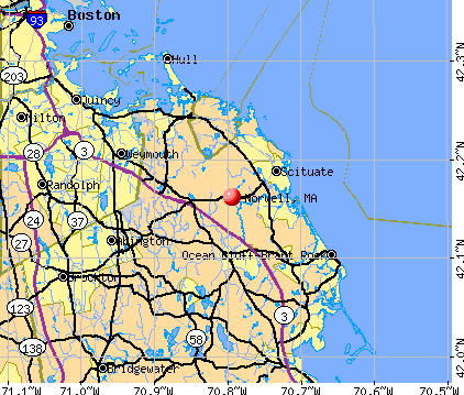
Norwell, Massachusetts

Submit your own pictures of this town and show them to the world
- OSM Map
- General Map
- Google Map
- MSN Map
Population change since 2000: +7.6%
 |
| Males: 5,035 | |
| Females: 5,471 |
| Median resident age: | 43.8 years |
| Massachusetts median age: | 39.2 years |
Zip codes: 02061.
| Norwell: | $162,133 |
| MA: | $94,488 |
Estimated per capita income in 2022: $81,329 (it was $37,222 in 2000)
Norwell town income, earnings, and wages data
Estimated median house or condo value in 2022: over $1,000,000 (it was $324,100 in 2000)
| Norwell: | over $1,000,000 |
| MA: | $534,700 |
Mean prices in 2022: all housing units: $585,203; detached houses: $620,100; townhouses or other attached units: $487,972; in 2-unit structures: $464,355; in 3-to-4-unit structures: $429,583; in 5-or-more-unit structures: $438,441; mobile homes: $207,706; occupied boats, rvs, vans, etc.: $17,153
Detailed information about poverty and poor residents in Norwell, MA


Compare current foreclosures near Norwell, MA:
| Photo | Address | Area | Beds / Baths | Price | Details |
|---|---|---|---|---|---|

|
#1
Prospect St
Norwell, MA 02061
|
5,483 sq. feet
|
5 baths 5 beds |
$1,760,000
|
show details |

|
#2
Douglas Ave
Norwell, MA 02061
|
740 sq. feet
|
1 baths 3 beds |
show details | |

|
#3
Stetson Shrine Ln
Norwell, MA 02061
|
1,494 sq. feet
|
1 baths 3 beds |
show details | |

|
#4
Ridge Hill Rd
Norwell, MA 02061
|
1,825 sq. feet
|
1 baths 3 beds |
show details | |

|
#5
Pine St
Norwell, MA 02061
|
2,036 sq. feet
|
2 baths 3 beds |
show details | |

|
#6
Circuit St
Norwell, MA 02061
|
1,773 sq. feet
|
2 baths 3 beds |
show details | |

|
#7
Boyd St
Boston, MA 02124
|
3,970 sq. feet
|
3 baths 9 beds |
$650,000
|
show details |

|
#8
Tall Oaks Dr Unit 508
South Weymouth, MA 02190
|
1,300 sq. feet
|
2 baths 2 beds |
$285,000
|
show details |

|
#9
Ormond St
Mattapan, MA 02126
|
4,252 sq. feet
|
3 baths 7 beds |
show details | |

|
#10
Bedford St Apt C-2
Whitman, MA 02382
|
1,610 sq. feet
|
2 baths 2 beds |
show details |
| Photo | Address | Area | Beds / Baths | Price | Details |
|---|---|---|---|---|---|

|
#11
Church St
Boston, MA 02122
|
3,663 sq. feet
|
3 baths 6 beds |
show details | |

|
#12
Willard St
Quincy, MA 02169
|
1,758 sq. feet
|
2 baths 3 beds |
show details | |

|
#13
Custer St
Brockton, MA 02301
|
1,200 sq. feet
|
1 baths 3 beds |
show details | |

|
#14
Welles Ave
Boston, MA 02124
|
3,903 sq. feet
|
4 baths 6 beds |
show details | |

|
#15
Cityview Ln Unit 104
Quincy, MA 02169
|
834 sq. feet
|
1 baths 1 beds |
show details | |

|
#16
Weir Street Ext
Hingham, MA 02043
|
4,332 sq. feet
|
3 baths 4 beds |
show details | |

|
#17
Randolph St
Abington, MA 02351
|
1,631 sq. feet
|
1 baths 4 beds |
show details | |

|
#18
Court St # 1
Whitman, MA 02382
|
1,620 sq. feet
|
3 baths 3 beds |
show details | |

|
#19
Fairmount St
Boston, MA 02124
|
3,486 sq. feet
|
4 baths 9 beds |
show details | |

|
#20
Codman St
Boston, MA 02124
|
3,096 sq. feet
|
4 baths 5 beds |
show details |
| Photo | Address | Area | Beds / Baths | Price | Details |
|---|---|---|---|---|---|

|
#21
Kennedy Rd
Stoughton, MA 02072
|
1,324 sq. feet
|
1 baths 3 beds |
show details | |

|
#22
Emilissa Ln
Weymouth, MA 02188
|
2,600 sq. feet
|
4 baths 4 beds |
show details | |

|
#23
Skyline Dr Apt 2
Braintree, MA 02184
|
535 sq. feet
|
1 baths 1 beds |
show details | |

|
#24
Ridgehill Rd
Canton, MA 02021
|
1,196 sq. feet
|
1 baths 3 beds |
show details | |

|
#25
Lawson St
Randolph, MA 02368
|
2,630 sq. feet
|
3 baths 3 beds |
show details | |

|
#26
Oakwood Ter
East Bridgewater, MA 02333
|
1,052 sq. feet
|
2 baths 3 beds |
show details | |

|
#27
Lisa Dr
Brockton, MA 02302
|
1,172 sq. feet
|
1 baths 3 beds |
show details | |

|
#28
Hughes St
Plymouth, MA 02360
|
1,286 sq. feet
|
1 baths 3 beds |
show details | |

|
#29
Quentin St
Quincy, MA 02169
|
2,642 sq. feet
|
4 baths 5 beds |
show details | |

|
#30
South St
Bridgewater, MA 02324
|
2,817 sq. feet
|
2 baths 3 beds |
show details |
| Photo | Address | Area | Beds / Baths | Price | Details |
|---|---|---|---|---|---|

|
#31
Marcy Rd
Mattapan, MA 02126
|
1,168 sq. feet
|
1 baths 3 beds |
show details | |

|
#32
Wampatuck St
Pembroke, MA 02359
|
1,760 sq. feet
|
2 baths 3 beds |
show details | |

|
#33
Violet St
Mattapan, MA 02126
|
1,713 sq. feet
|
2 baths 3 beds |
show details | |

|
#34
Pleasant St Unit 55
East Weymouth, MA 02189
|
1,228 sq. feet
|
2 baths 2 beds |
show details | |

|
#35
Littlefield St
Quincy, MA 02169
|
1,274 sq. feet
|
1 baths 4 beds |
show details | |

|
#36
Hollis Ave
Braintree, MA 02184
|
2,664 sq. feet
|
3 baths 5 beds |
show details | |

|
#37
Crickett Ln
Randolph, MA 02368
|
1,480 sq. feet
|
2 baths 3 beds |
show details | |

|
#38
Bowes Ave
Quincy, MA 02169
|
1,312 sq. feet
|
2 baths 3 beds |
show details | |

|
#39
Howard Ave
Holbrook, MA 02343
|
1,181 sq. feet
|
2 baths 2 beds |
show details | |

|
#40
Echo St
Brockton, MA 02301
|
1,527 sq. feet
|
2 baths 3 beds |
show details |
| Photo | Address | Area | Beds / Baths | Price | Details |
|---|---|---|---|---|---|

|
#41
Ferry St
Marshfield, MA 02050
|
979 sq. feet
|
1 baths 3 beds |
show details | |

|
#42
White Island Rd
Halifax, MA 02338
|
1,424 sq. feet
|
3 baths 4 beds |
show details | |

|
#43
Stanton St
Boston, MA 02124
|
3,736 sq. feet
|
3 baths 7 beds |
show details | |

|
#44
Jacqueline Ln
Plymouth, MA 02360
|
2,118 sq. feet
|
1 baths 4 beds |
show details | |

|
#45
Country Ln
Canton, MA 02021
|
2,808 sq. feet
|
3 baths 3 beds |
show details | |

|
#46
Yale Ave
Plymouth, MA 02360
|
1,524 sq. feet
|
3 baths 4 beds |
show details | |

|
#47
Fairmount St
Boston, MA 02124
|
3,014 sq. feet
|
3 baths 5 beds |
show details | |

|
#48
Walton St
Boston, MA 02124
|
2,916 sq. feet
|
3 baths 6 beds |
show details | |

|
#49
Lynn Rd
Brockton, MA 02302
|
1,172 sq. feet
|
1 baths 3 beds |
show details | |

|
Check over 1 million property listings on Foreclosure.com!
|
browse all offers | |||

- 10,01195.3%White alone
- 1811.7%Asian alone
- 1281.2%Hispanic
- 960.9%Two or more races
- 630.6%Black alone
- 190.2%Other race alone
- 80.08%American Indian alone
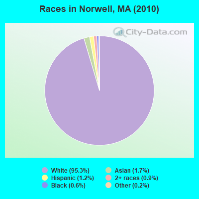
Races in Norwell detailed stats: ancestries, foreign born residents, place of birth
According to our research of Massachusetts and other state lists, there was 1 registered sex offender living in Norwell, Massachusetts as of June 16, 2024.
The ratio of all residents to sex offenders in Norwell is 10,506 to 1.
The ratio of registered sex offenders to all residents in this city is much lower than the state average.
Type |
2009 |
2010 |
2011 |
2012 |
2013 |
2014 |
2015 |
2016 |
2017 |
2018 |
2019 |
2020 |
2021 |
2022 |
|---|---|---|---|---|---|---|---|---|---|---|---|---|---|---|
| Murders (per 100,000) | 0 (0.0) | 1 (9.5) | 0 (0.0) | 0 (0.0) | 0 (0.0) | 0 (0.0) | 0 (0.0) | 0 (0.0) | 0 (0.0) | 0 (0.0) | 0 (0.0) | 0 (0.0) | 0 (0.0) | 0 (0.0) |
| Rapes (per 100,000) | 0 (0.0) | 3 (28.6) | 0 (0.0) | 0 (0.0) | 1 (9.4) | 2 (18.5) | 1 (9.2) | 2 (18.1) | 1 (9.0) | 2 (17.9) | 0 (0.0) | 0 (0.0) | 2 (17.0) | 1 (8.4) |
| Robberies (per 100,000) | 2 (19.2) | 2 (19.0) | 2 (18.9) | 2 (18.8) | 0 (0.0) | 1 (9.3) | 0 (0.0) | 0 (0.0) | 0 (0.0) | 0 (0.0) | 0 (0.0) | 1 (8.6) | 1 (8.5) | 0 (0.0) |
| Assaults (per 100,000) | 10 (96.0) | 8 (76.1) | 7 (66.2) | 7 (65.7) | 11 (103.6) | 7 (64.8) | 3 (27.5) | 10 (90.7) | 2 (17.9) | 7 (62.8) | 11 (99.1) | 8 (68.9) | 11 (93.5) | 3 (25.3) |
| Burglaries (per 100,000) | 51 (489.5) | 44 (418.8) | 60 (567.6) | 27 (253.4) | 28 (263.6) | 18 (166.6) | 14 (128.5) | 7 (63.5) | 6 (53.8) | 6 (53.8) | 8 (72.0) | 3 (25.9) | 7 (59.5) | 9 (75.8) |
| Thefts (per 100,000) | 89 (854.3) | 67 (637.7) | 92 (870.4) | 70 (656.9) | 89 (837.9) | 68 (629.3) | 39 (357.9) | 59 (534.9) | 35 (313.9) | 42 (376.9) | 38 (342.2) | 34 (293.0) | 33 (280.4) | 46 (387.7) |
| Auto thefts (per 100,000) | 5 (48.0) | 4 (38.1) | 7 (66.2) | 4 (37.5) | 5 (47.1) | 0 (0.0) | 1 (9.2) | 3 (27.2) | 2 (17.9) | 3 (26.9) | 5 (45.0) | 1 (8.6) | 4 (34.0) | 2 (16.9) |
| Arson (per 100,000) | 0 (0.0) | 0 (0.0) | 1 (9.5) | 0 (0.0) | 0 (0.0) | 0 (0.0) | 1 (9.2) | 1 (9.1) | 0 (0.0) | 0 (0.0) | 0 (0.0) | 0 (0.0) | 0 (0.0) | 0 (0.0) |
| City-Data.com crime index | 97.2 | 120.7 | 98.8 | 65.8 | 84.0 | 67.4 | 36.9 | 60.7 | 28.5 | 47.9 | 42.1 | 30.6 | 52.9 | 34.0 |
The City-Data.com crime index weighs serious crimes and violent crimes more heavily. Higher means more crime, U.S. average is 246.1. It adjusts for the number of visitors and daily workers commuting into cities.
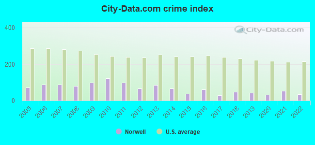
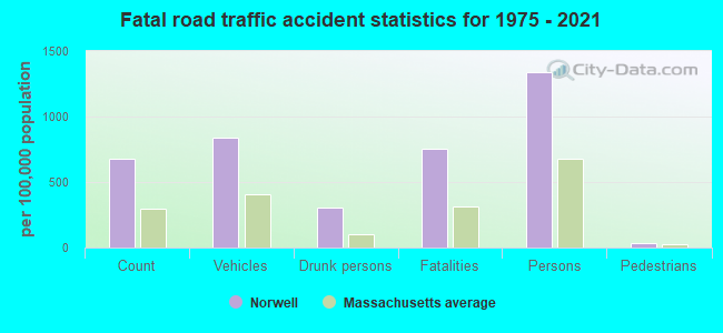
Crime rate in Norwell detailed stats: murders, rapes, robberies, assaults, burglaries, thefts, arson
Full-time law enforcement employees in 2021, including police officers: 26 (23 officers - 21 male; 2 female).
| Officers per 1,000 residents here: | 1.95 |
| Massachusetts average: | 2.53 |
 Recent articles from our blog. Our writers, many of them Ph.D. graduates or candidates, create easy-to-read articles on a wide variety of topics.

 | Nicer house in Pembroke or hold out for Norwell scituate duxbury? (72 replies) |
| Norwell, Cohasset, Scituate or Hanover? (26 replies) |
| MBTA in a state of disrepair. (1035 replies) |
| 2023 Real Estate Observations (5278 replies) |
| 2022 Real Estate Observations (1122 replies) |
| 2021 Real Estate Observations (1729 replies) |
Latest news from Norwell, MA collected exclusively by city-data.com from local newspapers, TV, and radio stations
Norwell, MA City Guides:
Ancestries: Irish (39.4%), English (15.2%), Italian (15.2%), German (8.3%), United States (6.3%), Scottish (4.1%).
Current Local Time: EST time zone
Incorporated in 1849
Elevation: 81 feet
Land area: 20.9 square miles.
Population density: 503 people per square mile (low).
332 residents are foreign born (1.6% Europe, 1.0% Asia).
| This town: | 3.4% |
| Massachusetts: | 12.2% |
| Norwell town: | 1.2% ($3,925) |
| Massachusetts: | 1.3% ($2,336) |
Nearest city with pop. 50,000+: Weymouth, MA  (7.4 miles , pop. 53,988).
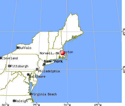
Nearest city with pop. 200,000+: Boston, MA (18.1 miles , pop. 589,141).
Nearest city with pop. 1,000,000+: Bronx, NY (182.1 miles , pop. 1,332,650).
Nearest cities:
), ), ), Latitude: 42.15 N, Longitude: 70.82 W
Area codes: 781, 339

Single-family new house construction building permits:
- 2022: 13 buildings, average cost: $622,300
- 2021: 12 buildings, average cost: $525,000
- 2020: 10 buildings, average cost: $490,500
- 2019: 8 buildings, average cost: $366,800
- 2018: 14 buildings, average cost: $516,400
- 2017: 16 buildings, average cost: $351,200
- 2016: 33 buildings, average cost: $357,000
- 2015: 23 buildings, average cost: $377,200
- 2014: 37 buildings, average cost: $330,200
- 2013: 35 buildings, average cost: $309,600
- 2012: 22 buildings, average cost: $365,200
- 2011: 8 buildings, average cost: $661,900
- 2010: 15 buildings, average cost: $372,200
- 2009: 6 buildings, average cost: $315,300
- 2008: 10 buildings, average cost: $315,300
- 2007: 17 buildings, average cost: $315,200
- 2006: 22 buildings, average cost: $315,600
- 2005: 29 buildings, average cost: $313,800
- 2004: 28 buildings, average cost: $323,700
- 2003: 56 buildings, average cost: $271,800
- 2002: 57 buildings, average cost: $245,600
- 2001: 35 buildings, average cost: $250,100
- 2000: 65 buildings, average cost: $156,700
- 1999: 37 buildings, average cost: $276,100
- 1998: 29 buildings, average cost: $230,100
- 1997: 37 buildings, average cost: $207,600
| Here: | 2.9% |
| Massachusetts: | 3.5% |
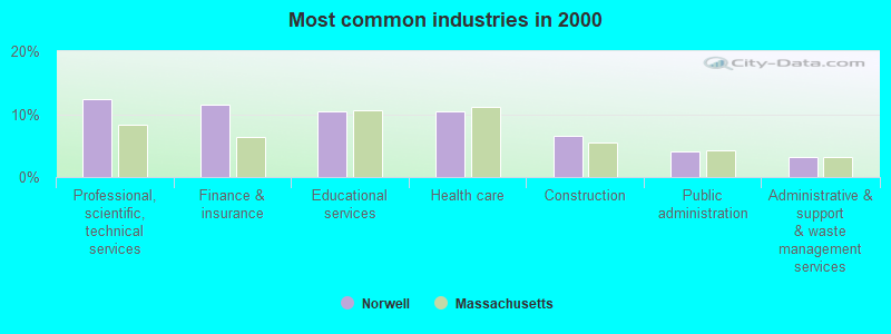
- Professional, scientific, technical services (12.4%)
- Finance & insurance (11.5%)
- Educational services (10.4%)
- Health care (10.4%)
- Construction (6.6%)
- Public administration (4.1%)
- Administrative & support & waste management services (3.2%)
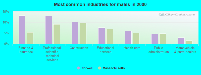
- Finance & insurance (13.1%)
- Professional, scientific, technical services (12.9%)
- Construction (10.1%)
- Educational services (7.5%)
- Health care (6.1%)
- Public administration (4.5%)
- Motor vehicle & parts dealers (2.9%)
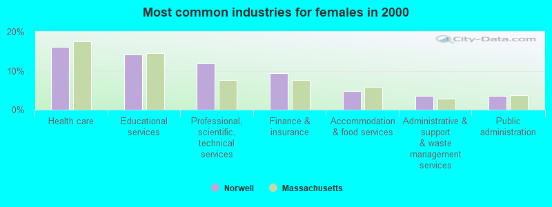
- Health care (16.0%)
- Educational services (14.2%)
- Professional, scientific, technical services (11.8%)
- Finance & insurance (9.3%)
- Accommodation & food services (4.8%)
- Administrative & support & waste management services (3.6%)
- Public administration (3.5%)
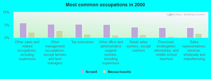
- Other sales and related occupations, including supervisors (5.8%)
- Other management occupations, except farmers and farm managers (5.3%)
- Top executives (5.2%)
- Other office and administrative support workers, including supervisors (5.2%)
- Retail sales workers, except cashiers (4.2%)
- Preschool, kindergarten, elementary, and middle school teachers (3.9%)
- Sales representatives, services, wholesale and manufacturing (3.9%)
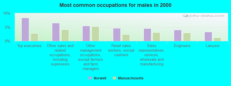
- Top executives (8.4%)
- Other sales and related occupations, including supervisors (6.5%)
- Other management occupations, except farmers and farm managers (5.5%)
- Retail sales workers, except cashiers (4.7%)
- Sales representatives, services, wholesale and manufacturing (4.5%)
- Engineers (4.0%)
- Lawyers (3.3%)

- Other office and administrative support workers, including supervisors (8.0%)
- Preschool, kindergarten, elementary, and middle school teachers (7.0%)
- Secretaries and administrative assistants (6.3%)
- Registered nurses (5.6%)
- Other management occupations, except farmers and farm managers (5.0%)
- Other sales and related occupations, including supervisors (4.9%)
- Retail sales workers, except cashiers (3.5%)
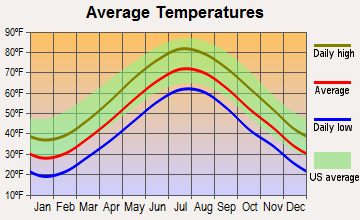
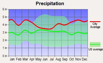
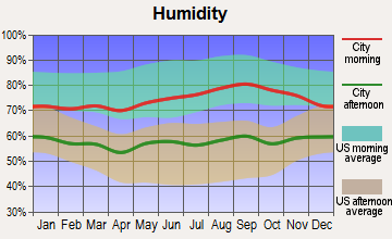
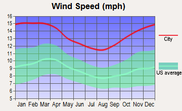
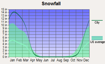
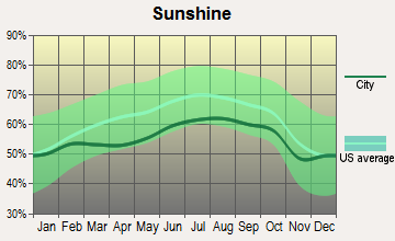
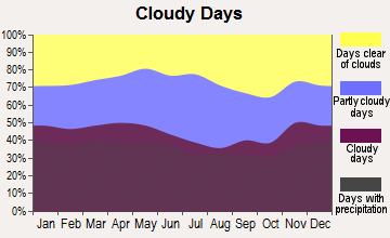
Average climate in Norwell, Massachusetts
Based on data reported by over 4,000 weather stations
(lower is better)
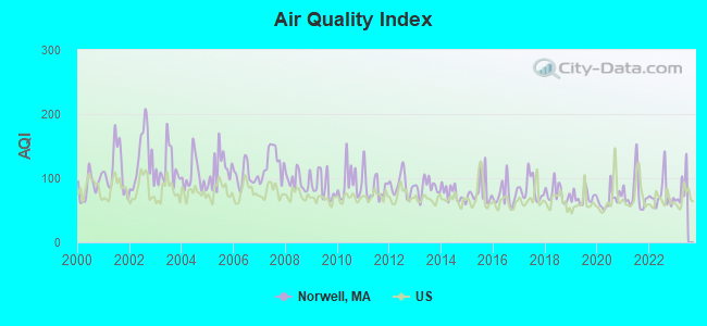
Air Quality Index (AQI) level in 2022 was 74.3. This is about average.
| City: | 74.3 |
| U.S.: | 72.6 |
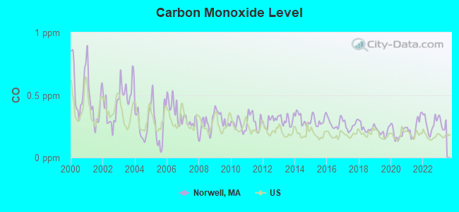
Carbon Monoxide (CO) [ppm] level in 2022 was 0.270. This is about average. Closest monitor was 10.0 miles away from the city center.
| City: | 0.270 |
| U.S.: | 0.251 |
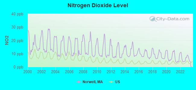
Nitrogen Dioxide (NO2) [ppb] level in 2022 was 6.36. This is worse than average. Closest monitor was 9.6 miles away from the city center.
| City: | 6.36 |
| U.S.: | 5.11 |
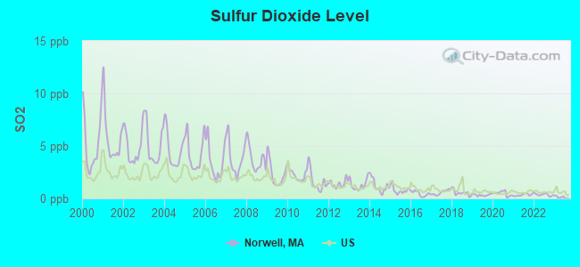
Sulfur Dioxide (SO2) [ppb] level in 2022 was 0.358. This is significantly better than average. Closest monitor was 10.0 miles away from the city center.
| City: | 0.358 |
| U.S.: | 1.515 |
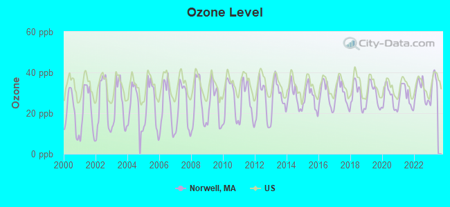
Ozone [ppb] level in 2022 was 30.7. This is about average. Closest monitor was 9.6 miles away from the city center.
| City: | 30.7 |
| U.S.: | 33.3 |
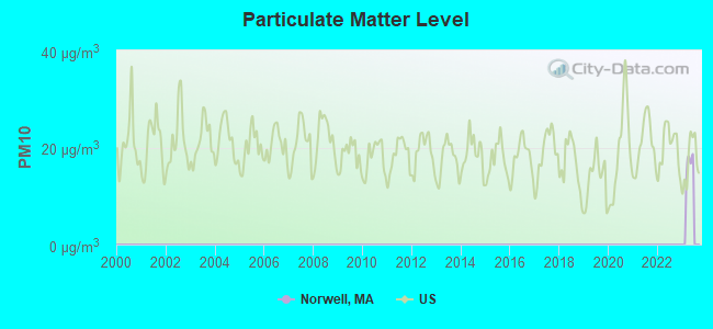
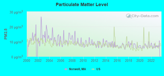
Particulate Matter (PM2.5) [µg/m3] level in 2022 was 7.02. This is about average. Closest monitor was 9.6 miles away from the city center.
| City: | 7.02 |
| U.S.: | 8.11 |
Tornado activity:
Norwell-area historical tornado activity is below Massachusetts state average. It is 59% smaller than the overall U.S. average.
On 6/9/1953, a category F4 (max. wind speeds 207-260 mph) tornado 37.3 miles away from the Norwell town center killed 90 people and injured 1228 people and caused between $50,000,000 and $500,000,000 in damages.
On 6/9/1953, a category F3 (max. wind speeds 158-206 mph) tornado 20.7 miles away from the town center injured 17 people and caused between $500,000 and $5,000,000 in damages.
Earthquake activity:
Norwell-area historical earthquake activity is significantly above Massachusetts state average. It is 74% smaller than the overall U.S. average.On 10/7/1983 at 10:18:46, a magnitude 5.3 (5.1 MB, 5.3 LG, 5.1 ML, Class: Moderate, Intensity: VI - VII) earthquake occurred 217.2 miles away from Norwell center
On 4/20/2002 at 10:50:47, a magnitude 5.3 (5.3 ML, Depth: 3.0 mi) earthquake occurred 218.1 miles away from the city center
On 10/16/2012 at 23:12:25, a magnitude 4.7 (4.7 ML, Depth: 10.0 mi, Class: Light, Intensity: IV - V) earthquake occurred 100.3 miles away from the city center
On 1/19/1982 at 00:14:42, a magnitude 4.7 (4.5 MB, 4.7 MD, 4.5 LG) earthquake occurred 101.2 miles away from Norwell center
On 4/20/2002 at 10:50:47, a magnitude 5.2 (5.2 MB, 4.2 MS, 5.2 MW, 5.0 MW) earthquake occurred 217.5 miles away from Norwell center
On 8/22/1992 at 12:20:32, a magnitude 4.8 (4.8 MB, 3.8 MS, 4.7 LG, Depth: 6.2 mi) earthquake occurred 212.4 miles away from the city center
Magnitude types: regional Lg-wave magnitude (LG), body-wave magnitude (MB), duration magnitude (MD), local magnitude (ML), surface-wave magnitude (MS), moment magnitude (MW)
Natural disasters:
The number of natural disasters in Plymouth County (26) is a lot greater than the US average (15).Major Disasters (Presidential) Declared: 17
Emergencies Declared: 9
Causes of natural disasters: Floods: 11, Storms: 9, Hurricanes: 7, Snows: 3, Snowstorms: 3, Blizzards: 2, Winter Storms: 2, Heavy Rain: 1, Snowfall: 1, Tropical Storm: 1, Wind: 1 (Note: some incidents may be assigned to more than one category).
Hospitals and medical centers in Norwell:
Amtrak stations near Norwell:
- 18 miles: ROUTE 128 (WESTWOOD, UNIVERSITY AVE. & RTE. 128) . Services: ticket office, enclosed waiting area, public restrooms, public payphones, vending machines, paid short-term parking, taxi stand, public transit connection.
- 19 miles: BOSTON (SO. STA) (BOSTON, ATLANTIC AVE. & SUMMER ST.) . Services: ticket office, fully wheelchair accessible, enclosed waiting area, public restrooms, public payphones, full-service food facilities and snack bar, ATM, paid short-term parking, paid long-term parking, call for car rental service, taxi stand, intercity bus service, public transit connection.
- 19 miles: BACK BAY (BOSTON, 145 DARTMOUTH ST.) . Services: ticket office, partially wheelchair accessible, enclosed waiting area, public restrooms, public payphones, vending machines, ATM, paid short-term parking, paid long-term parking, call for car rental service, taxi stand, public transit connection.
Operable nuclear power plant near Norwell:
- 16 miles: Pilgrim in Plymouth, MA.
Colleges/universities with over 2000 students nearest to Norwell:
- Massasoit Community College (about 11 miles; Brockton, MA; Full-time enrollment: 5,442)
- Quincy College (about 12 miles; Quincy, MA; FT enrollment: 3,184)
- Bridgewater State University (about 14 miles; Bridgewater, MA; FT enrollment: 9,802)
- Stonehill College (about 15 miles; Easton, MA; FT enrollment: 2,563)
- University of Massachusetts-Boston (about 16 miles; Boston, MA; FT enrollment: 12,625)
- Curry College (about 17 miles; Milton, MA; FT enrollment: 2,586)
- Northeastern University (about 19 miles; Boston, MA; FT enrollment: 27,758)
Public high schools in Norwell:
- NORWELL HIGH (Students: 641, Location: 18 SOUTH STREET, Grades: 9-12)
- SOUTH SHORE CHARTER PUBLIC SCHOOL (Students: 494, Location: 100 LONGWATER CIRCLE, Grades: KG-12, Charter school)
Public elementary/middle schools in Norwell:
- WILLIAM G VINAL (Students: 572, Location: 102 OLD OAKEN BUCKET ROAD, Grades: PK-5)
- GRACE FARRAR COLE (Students: 562, Location: 81 HIGH STREET, Grades: PK-5)
- NORWELL MIDDLE SCHOOL (Students: 497, Location: 328 MAIN STREET, Grades: 6-8)
Library in Norwell:
Points of interest:
Notable locations in Norwell: Norwell Industrial Park (A), Jacobs Farm Museum (B), Norwell Fire Department Station 3 (C), Norwell Fire Department Station 2 Headquarters (D), Norwell Fire Department Station 1 (E), Norwell Public Library (F), Norwell High School Library (G), Norwell Town Hall (H). Display/hide their locations on the map
Churches in Norwell include: First Parish of Norwell Church (A), Assinippi Universalist Church (B). Display/hide their locations on the map
Cemeteries: Church (1), Pinehurst Cemetery (2), Old First Parish Cemetery (3), First Parish Cemetery (4), Bowker Cemetery (5), Stockbridge Cemetery (6). Display/hide their locations on the map
Lakes, reservoirs, and swamps: Hatch Pond (A), Black Pond (B), Peterson Pond (C), Turner Pond (D), Cranberry Bog Reservoir (E), Torrey Pond (F), Jacobs Pond (G), Bound Brook Pond (H). Display/hide their locations on the map
Streams, rivers, and creeks: Wildcat Creek (A), Stony Brook (B), Silver Brook (C), Second Herring Brook (D), Cove Brook (E). Display/hide their locations on the map
Parks in Norwell include: Salt Marsh Conservation Area (1), Norwell Village Area Historic District (2), Garfield Park (3), Fogg Park (4), Albert Norris Conservation Area (5), Gaffield Park (6). Display/hide their locations on the map
Tourist attraction: Norwell Historical Society (Historical Places & Services; 328 Main Street) (1). Display/hide its approximate location on the map
Hotel: Park View Inn (350 Washington) (1). Display/hide its approximate location on the map
Birthplace of: Jan Brett - Illustrator, Jeff Corwin - Television personality, Gerry Corcoran - College basketball player (Quinnipiac Bobcats).
Drinking water stations with addresses in Norwell and their reported violations in the past:
NORWELL WATER DEPARTMENT (Population served: 11,114, Groundwater):Past health violations:BEARFOOT CREEK (Serves NH, Population served: 25, Groundwater):Past monitoring violations:
- MCL, Monthly (TCR) - In DEC-2006, Contaminant: Coliform. Follow-up actions: St AO (w/o penalty) issued (MAY-16-2007), St Compliance achieved (MAY-16-2007)
- Monitoring and Reporting (DBP) - Between OCT-2006 and DEC-2006, Contaminant: TTHM. Follow-up actions: St AO (w/o penalty) issued (JAN-31-2007)
- Monitoring and Reporting (DBP) - Between OCT-2006 and DEC-2006, Contaminant: Total Haloacetic Acids (HAA5). Follow-up actions: St AO (w/o penalty) issued (JAN-31-2007)
- One regular monitoring violation
Past health violations:Past monitoring violations:
- MCL, Average - Between JUL-2013 and SEP-2013, Contaminant: Gross Alpha, Excl. Radon and U. Follow-up actions: St Public Notif requested (AUG-23-2013), St Violation/Reminder Notice (AUG-23-2013), St Public Notif received (SEP-11-2013), St Compliance achieved (APR-18-2014)
- MCL, Average - Between APR-2013 and JUN-2013, Contaminant: Gross Alpha, Excl. Radon and U. Follow-up actions: St Public Notif requested (AUG-14-2013), St Violation/Reminder Notice (AUG-14-2013), St Public Notif received (AUG-27-2013), St Compliance achieved (APR-18-2014)
- MCL, Average - Between JAN-2013 and MAR-2013, Contaminant: Gross Alpha, Excl. Radon and U. Follow-up actions: St Public Notif requested (FEB-28-2013), St Violation/Reminder Notice (FEB-28-2013), St Formal NOV issued (MAR-20-2013), St Public Notif received (MAR-27-2013), St Compliance achieved (APR-18-2014)
- MCL, Average - Between JUL-2012 and SEP-2012, Contaminant: Gross Alpha, Excl. Radon and U. Follow-up actions: St Public Notif requested (OCT-11-2012), St Violation/Reminder Notice (OCT-11-2012), St Public Notif received (OCT-18-2012), St Formal NOV issued (MAR-20-2013), St Compliance achieved (APR-18-2014)
- MCL, Average - Between APR-2012 and JUN-2012, Contaminant: Gross Alpha, Excl. Radon and U. Follow-up actions: St Public Notif requested (JUL-31-2012), St Violation/Reminder Notice (JUL-31-2012), St Public Notif received (AUG-07-2012), St Formal NOV issued (MAR-20-2013), St Compliance achieved (APR-18-2014)
- One regular monitoring violation
| This town: | 2.9 people |
| Massachusetts: | 2.5 people |
| This town: | 80.1% |
| Whole state: | 63.0% |
| This town: | 2.6% |
| Whole state: | 7.0% |
Likely homosexual households (counted as self-reported same-sex unmarried-partner households)
- Lesbian couples: 0.5% of all households
- Gay men: 0.3% of all households
| This town: | 1.9% |
| Whole state: | 9.3% |
| This town: | 0.8% |
| Whole state: | 4.4% |
42 people in emergency and transitional shelters (with sleeping facilities) for people experiencing homelessness in 2010
201 people in nursing homes in 2000
8 people in homes for the mentally retarded in 2000
Banks with branches in Norwell (2011 data):
- RBS Citizens, National Association: Queen Anne Branch at 36 Washington Street, branch established on 1967/06/28; Norwell Stop And Shop Branch at 468 Washington Street, branch established on 2002/07/25. Info updated 2007/09/19: Bank assets: $106,940.6 mil, Deposits: $75,690.2 mil, headquarters in Providence, RI, positive income, 1135 total offices, Holding Company: Uk Financial Investments Limited
- Scituate Federal Savings Bank: Norwell Branch at 1 River Street, branch established on 2000/06/01. Info updated 2011/07/21: Bank assets: $261.5 mil, Deposits: $218.7 mil, headquarters in Scituate, MA, positive income, Mortgage Lending Specialization, 5 total offices
- South Shore Savings Bank: Norwell Branch at 400 Washington Street, branch established on 1978/10/15. Info updated 2011/08/26: Bank assets: $950.4 mil, Deposits: $661.6 mil, headquarters in South Weymouth, MA, positive income, Commercial Lending Specialization, 13 total offices, Holding Company: South Shore Bancorp Mhc
- Rockland Trust Company: Queen Ann's Shopping Center Branch at 10 Pond St, branch established on 1967/06/28. Info updated 2009/05/20: Bank assets: $4,974.4 mil, Deposits: $3,903.9 mil, headquarters in Rockland, MA, positive income, Commercial Lending Specialization, 67 total offices, Holding Company: Independent Bank Corp.
- Eastern Bank: Norwell Branch at 80 Washington Street, branch established on 1962/11/26. Info updated 2011/03/30: Bank assets: $7,812.9 mil, Deposits: $6,295.8 mil, headquarters in Boston, MA, positive income, Commercial Lending Specialization, 94 total offices, Holding Company: Eastern Bank Corporation
- Sovereign Bank, National Association: Norwell Branch at 69 Washington Street, branch established on 2007/08/06. Info updated 2012/01/31: Bank assets: $78,146.9 mil, Deposits: $48,042.9 mil, headquarters in Wilmington, DE, positive income, Commercial Lending Specialization, 718 total offices, Holding Company: Banco Santander, S.A.
For population 15 years and over in Norwell:
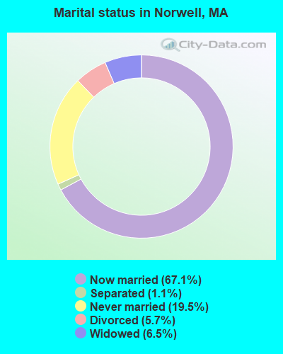
- Never married: 19.5%
- Now married: 67.1%
- Separated: 1.1%
- Widowed: 6.5%
- Divorced: 5.7%
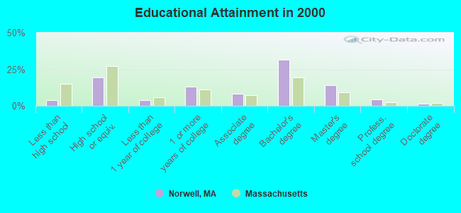
For population 25 years and over in Norwell:
- High school or higher: 96.3%
- Bachelor's degree or higher: 51.9%
- Graduate or professional degree: 20.2%
- Unemployed: 1.9%
- Mean travel time to work (commute): 34.3 minutes
| Here: | 9.4 |
| Massachusetts average: | 13.1 |


Graphs represent county-level data. Detailed 2008 Election Results
Religion statistics for Norwell, MA (based on Plymouth County data)


| Religion | Adherents | Congregations |
|---|---|---|
| Catholic | 165,985 | 35 |
| Mainline Protestant | 23,724 | 91 |
| Evangelical Protestant | 13,159 | 96 |
| Other | 6,129 | 43 |
| Orthodox | 1,140 | 3 |
| Black Protestant | 611 | 5 |
| None | 284,171 | - |
Food Environment Statistics:
| Here: | 1.74 / 10,000 pop. |
| Massachusetts: | 1.98 / 10,000 pop. |
| Plymouth County: | 0.04 / 10,000 pop. |
| State: | 0.05 / 10,000 pop. |
| This county: | 2.84 / 10,000 pop. |
| Massachusetts: | 2.22 / 10,000 pop. |
| Here: | 2.20 / 10,000 pop. |
| Massachusetts: | 1.77 / 10,000 pop. |
| Here: | 7.37 / 10,000 pop. |
| Massachusetts: | 8.76 / 10,000 pop. |
| Here: | 7.9% |
| State: | 8.1% |
| This county: | 21.7% |
| State: | 22.5% |
| This county: | 16.3% |
| Massachusetts: | 16.5% |
5.54% of this county's 2020 resident taxpayers moved to other counties in 2021 ($85,482 average adjusted gross income)
| Here: | 5.54% |
| Massachusetts average: | 7.18% |
0.01% of residents moved to foreign countries ($80 average AGI)
Plymouth County: 0.01% Massachusetts average: 0.02%
Top counties to which taxpayers relocated from this county between 2020 and 2021:
| to Bristol County, MA | |
| to Norfolk County, MA | |
| to Suffolk County, MA |
| Businesses in Norwell, MA | ||||
| Name | Count | Name | Count | |
|---|---|---|---|---|
| 7-Eleven | 1 | McDonald's | 1 | |
| AT&T | 1 | New Balance | 1 | |
| Audi | 1 | Nike | 2 | |
| BMW | 1 | Nissan | 1 | |
| CVS | 1 | Rite Aid | 1 | |
| Decora Cabinetry | 4 | SAS Shoes | 1 | |
| Dressbarn | 1 | Stop & Shop | 1 | |
| Dunkin Donuts | 3 | T.J.Maxx | 1 | |
| FedEx | 6 | Taco Bell | 1 | |
| KFC | 1 | UPS | 9 | |
| MasterBrand Cabinets | 10 | Vans | 1 | |
Strongest AM radio stations in Norwell:
- WBZ (1030 AM; 50 kW; BOSTON, MA; Owner: INFINITY BROADCASTING OPERATIONS, INC.)
- WEEI (850 AM; 50 kW; BOSTON, MA; Owner: ENTERCOM BOSTON LICENSE, LLC)
- WRKO (680 AM; 50 kW; BOSTON, MA; Owner: ENTERCOM BOSTON LICENSE, LLC)
- WWZN (1510 AM; 50 kW; BOSTON, MA; Owner: ROSE CITY RADIO CORPORATION)
- WKOX (1200 AM; 50 kW; FRAMINGHAM, MA; Owner: CAPSTAR TX LIMITED PARTNERSHIP)
- WBIX (1060 AM; 40 kW; NATICK, MA; Owner: LANGER BROADCASTING CORPORATION)
- WUNR (1600 AM; 20 kW; BROOKLINE, MA; Owner: CHAMPION BROADCASTING SYSTEMS, INC.)
- WALE (990 AM; 50 kW; GREENVILLE, RI; Owner: NORTH AMERICAN BROADCASTING CO., INC.)
- WAMG (890 AM; 25 kW; DEDHAM, MA; Owner: MEGA COMMUNICATIONS OF DEDHAM LICENSEE, LLC)
- WRCA (1330 AM; 25 kW; WALTHAM, MA; Owner: WRCA LICENSE, LLC)
- WMKI (1260 AM; 5 kW; BOSTON, MA; Owner: ABC, INC.)
- WPLM (1390 AM; 5 kW; PLYMOUTH, MA; Owner: PLYMOUTH ROCK BROADCASTING CO., INC.)
- WCRN (830 AM; 50 kW; WORCESTER, MA; Owner: CARTER BROADCASTING CORPORATION)
Strongest FM radio stations in Norwell:
- WATD-FM (95.9 FM; MARSHFIELD, MA; Owner: MARSHFIELD BROADCASTING CO., INC.)
- WXKS-FM (107.9 FM; MEDFORD, MA; Owner: AMFM RADIO LICENSES, L.L.C.)
- WMJX (106.7 FM; BOSTON, MA; Owner: GREATER BOSTON RADIO, INC.)
- WBMX (98.5 FM; BOSTON, MA; Owner: INFINITY RADIO OPERATIONS INC.)
- WBOS (92.9 FM; BROOKLINE, MA; Owner: GREATER BOSTON RADIO, INC.)
- WJMN (94.5 FM; BOSTON, MA; Owner: AMFM RADIO LICENSES, L.L.C.)
- WCRB (102.5 FM; WALTHAM, MA; Owner: CHARLES RIVER BROADCASTING WCRB LICE)
- WTKK (96.9 FM; BOSTON, MA; Owner: GREATER BOSTON RADIO, INC.)
- WROR-FM (105.7 FM; FRAMINGHAM, MA; Owner: GREATER BOSTON RADIO, INC.)
- WGBH (89.7 FM; BOSTON, MA; Owner: WGBH EDUCATIONAL FOUNDATION)
- WRPS (88.3 FM; ROCKLAND, MA; Owner: ROCKLAND PUBLIC SCHOOLS)
- WBCN (104.1 FM; BOSTON, MA; Owner: HEMISPHERE BROADCASTING CORPORATION)
- WZLX (100.7 FM; BOSTON, MA; Owner: INFINITY BROADCASTING CORPORATION OF BOSTON)
- W267AI (101.3 FM; BOSTON, MA; Owner: MCC BROADCASTING COMPANY, INC.)
- WBUR-FM (90.9 FM; BOSTON, MA; Owner: TRUSTEES OF BOSTON UNIVERSITY)
- WBOT (97.7 FM; BROCKTON, MA; Owner: RADIO ONE LICENSES, LLC)
- WERS (88.9 FM; BOSTON, MA; Owner: EMERSON COLLEGE)
- WODS (103.3 FM; BOSTON, MA; Owner: INFINITY BROADCASTING OPERATIONS, INC.)
- WHRB (95.3 FM; CAMBRIDGE, MA; Owner: HARVARD RADIO BROADCASTING CO., INC.)
- WPLM-FM (99.1 FM; PLYMOUTH, MA; Owner: PLYMOUTH ROCK BROADCASTING CO., INC.)
TV broadcast stations around Norwell:
- WWDP (Channel 46; NORWELL, MA; Owner: NORWELL TELEVISION, LLC)
- WCVB-TV (Channel 5; BOSTON, MA; Owner: WCVB HEARST-ARGYLE TV, INC.)
- WGBH-TV (Channel 2; BOSTON, MA; Owner: WGBH EDUCATIONAL FOUNDATION)
- WHDH-TV (Channel 7; BOSTON, MA; Owner: WHDH-TV)
- WMFP (Channel 62; LAWRENCE, MA; Owner: WSAH LICENSE, INC.)
- WSBK-TV (Channel 38; BOSTON, MA; Owner: VIACOM INC.)
- WBPX (Channel 68; BOSTON, MA; Owner: PAXSON BOSTON-68 LICENSE, INC.)
- WLVI-TV (Channel 56; CAMBRIDGE, MA; Owner: WLVI, INC.)
- WBZ-TV (Channel 4; BOSTON, MA; Owner: VIACOM INC.)
- WGBX-TV (Channel 44; BOSTON, MA; Owner: WGBH EDUCATIONAL FOUNDATION)
- WFXT (Channel 25; BOSTON, MA; Owner: FOX TELEVISION STATIONS INC.)
- WTMU-LP (Channel 32; BOSTON, MA; Owner: ZGS BOSTON, INC.)
- WCEA-LP (Channel 58; BOSTON, MA; Owner: CHANNEL 19 TV CORPORATION)
- W40BO (Channel 40; BOSTON, MA; Owner: PAXSON COMMUNICATIONS LPTV, INC.)
- WLNE-TV (Channel 6; NEW BEDFORD, MA; Owner: FREEDOM BROADCASTING OF SOUTHERN NEW ENGLAND, INC.)
- WPRI-TV (Channel 12; PROVIDENCE, RI; Owner: TVL BROADCASTING OF RHODE ISLAND, LLC)
- WNAC-TV (Channel 64; PROVIDENCE, RI; Owner: WNAC, LLC)
- WUTF (Channel 66; MARLBOROUGH, MA; Owner: TELEFUTURA BOSTON LLC)
- WLWC (Channel 28; NEW BEDFORD, MA; Owner: C-28 FCC LICENSEE SUBSIDIARY, LLC)
- WJAR (Channel 10; PROVIDENCE, RI; Owner: OUTLET BROADCASTING, INC.)
- WSBE-TV (Channel 36; PROVIDENCE, RI; Owner: RHODE ISLAND PUBLIC TELECOM. AUTHORITY)
- WUNI (Channel 27; WORCESTER, MA; Owner: ENTRAVISION HOLDINGS, LLC)
- National Bridge Inventory (NBI) Statistics
- 6Number of bridges
- 115ft / 34.9mTotal length
- $26,355,000Total costs
- 154,798Total average daily traffic
- 12,734Total average daily truck traffic
- 186,041Total future (year 2031) average daily traffic
FCC Registered Antenna Towers:
13 (See the full list of FCC Registered Antenna Towers in Norwell)FCC Registered Broadcast Land Mobile Towers:
9 (See the full list of FCC Registered Broadcast Land Mobile Towers in Norwell, MA)FCC Registered Microwave Towers:
7 (See the full list of FCC Registered Microwave Towers in this town)FCC Registered Maritime Coast & Aviation Ground Towers:
1 (See the full list of FCC Registered Maritime Coast & Aviation Ground Towers)FCC Registered Amateur Radio Licenses:
38 (See the full list of FCC Registered Amateur Radio Licenses in Norwell)FAA Registered Aircraft:
6- Aircraft: CIRRUS DESIGN CORP SR22 (Category: Land, Seats: 4, Weight: Up to 12,499 Pounds), Engine: CONT MOTOR IO-550-N (310 HP) (Reciprocating)
N-Number: 122TX, N122TX, N-122TX, Serial Number: 2989, Year manufactured: 2008, Airworthiness Date: 04/07/2008, Certificate Issue Date: 07/25/2008
Registrant (Co-Owned): Dental Management Co Inc Dba Cranberry, 409 Circuit St, Norwell, MA 02061, Other Owners: Oral Surgery Management Co Rochester, S Colton Dds Pc Timothy - Aircraft: SCHLEICHER ASW-27 (Category: Land, Weight: Up to 12,499 Pounds), Engine: None
N-Number: 27HH, N27HH, N-27HH, Serial Number: 27066, Year manufactured: 1997, Airworthiness Date: 03/31/2005, Certificate Issue Date: 08/27/2013
Registrant (Individual): Steven M Waitekaitis, Po Box 660, Norwell, MA 02061 - Aircraft: BOMBARDIER INC BD-100-1A10 (Category: Land, Engines: 2, Seats: 8, Weight: 20,000+ Pounds), Engine: HONEYWELL AS907-1-1A (6944 Pounds of Thrust) (Turbo-fan)
N-Number: 400CH, N400CH, N-400CH, Serial Number: 20051, Year manufactured: 2005, Airworthiness Date: 09/11/2005, Certificate Issue Date: 04/24/2012
Registrant (Corporation): Clean Harbors Environmental Services Inc, 42 Longwater Dr, Norwell, MA 02061 - Aircraft: CESSNA 414A (Category: Land, Engines: 2, Seats: 8, Weight: Up to 12,499 Pounds, Speed: 198 mph), Engine: CONT MOTOR TSIO-520 SER (300 HP) (Reciprocating)
N-Number: 414MP, N414MP, N-414MP, Serial Number: 414A0317, Year manufactured: 1979, Airworthiness Date: 07/13/1984, Certificate Issue Date: 03/11/2020
Registrant (Individual): Daniel R Bawabe, 301 Mount Blue St, Norwell, MA 02061 - Aircraft: PIPER PA-32-300 (Category: Land, Seats: 6, Weight: Up to 12,499 Pounds, Speed: 126 mph), Engine: LYCOMING TI0-540 SER (310 HP) (Reciprocating)
N-Number: 4173R, N4173R, N-4173R, Serial Number: 32-40507, Year manufactured: 1968, Airworthiness Date: 10/04/1968, Certificate Issue Date: 02/04/2000
Registrant (Individual): Kevin M Callahan, 129 Parker St, Norwell, MA 02061 - Aircraft: KNIGHT AARON SONEX (Category: Land, Seats: 2, Weight: Up to 12,499 Pounds), Engine: JABIRU 3300 (120 HP) (4 Cycle)
N-Number: 771AK, N771AK, N-771AK, Serial Number: 1024, Year manufactured: 2008, Airworthiness Date: 05/29/2008, Certificate Issue Date: 09/25/2007
Registrant (Individual): Aaron Knight, 324 Grove St, Norwell, MA 02061
2002 - 2018 National Fire Incident Reporting System (NFIRS) incidents
- Fire incident types reported to NFIRS in Norwell, MA
- 37542.6%Structure Fires
- 35139.9%Outside Fires
- 13615.5%Mobile Property/Vehicle Fires
- 182.0%Other
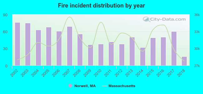 Based on the data from the years 2002 - 2018 the average number of fire incidents per year is 52. The highest number of fire incidents - 76 took place in 2002, and the least - 16 in 2018. The data has a dropping trend.
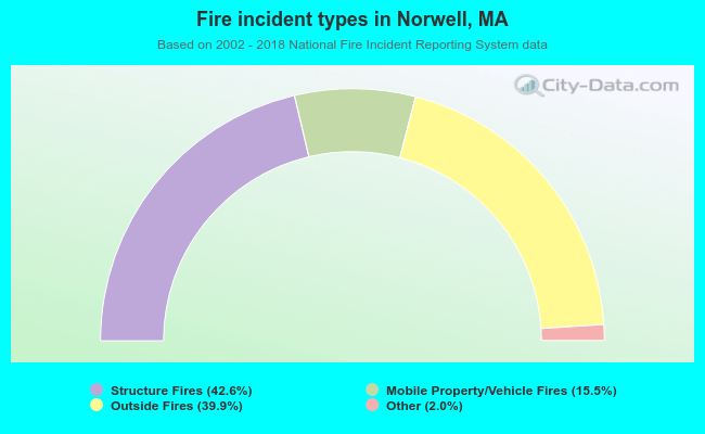 When looking into fire subcategories, the most incidents belonged to: Structure Fires (42.6%), and Outside Fires (39.9%).
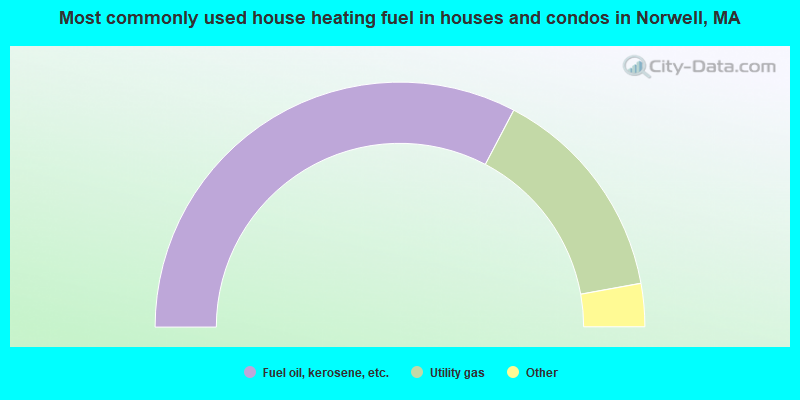
- 65.4%Fuel oil, kerosene, etc.
- 28.9%Utility gas
- 2.8%Electricity
- 1.9%Bottled, tank, or LP gas
- 1.0%Wood
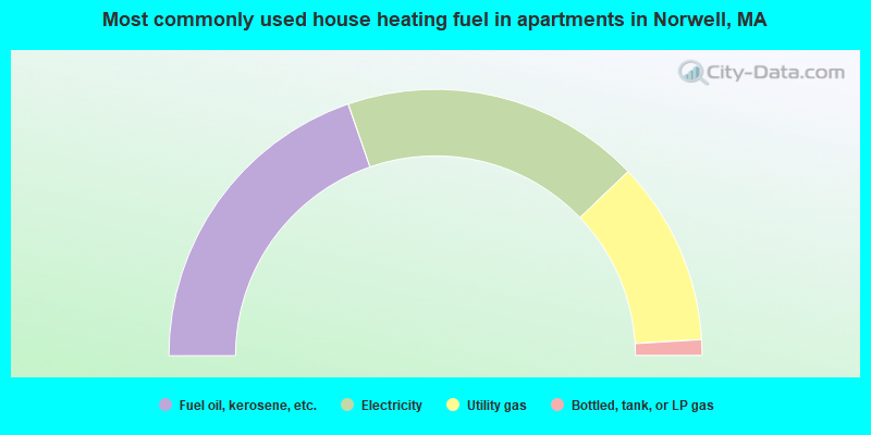
- 39.4%Fuel oil, kerosene, etc.
- 36.3%Electricity
- 22.4%Utility gas
- 1.9%Bottled, tank, or LP gas
Norwell compared to Massachusetts state average:
- Median household income above state average.
- Median house value above state average.
- Unemployed percentage significantly below state average.
- Black race population percentage significantly below state average.
- Hispanic race population percentage significantly below state average.
- Median age above state average.
- Foreign-born population percentage significantly below state average.
- Renting percentage significantly below state average.
- Length of stay since moving in significantly above state average.
- Number of rooms per house significantly below state average.
- House age significantly below state average.
- Percentage of population with a bachelor's degree or higher above state average.
Norwell on our top lists:
- #4 on the list of "Top 101 cities with largest percentage of males in industries: retail florists (population 5,000+)"
- #15 on the list of "Top 101 cities with largest percentage of females in industries: metals and minerals, except petroleum, merchant wholesalers (population 5,000+)"
- #18 on the list of "Top 101 cities with the most people taking a ferryboat to work (population 5,000+)"
- #19 on the list of "Top 101 cities with largest percentage of males in occupations: bookkeeping, accounting, and auditing clerks (population 5,000+)"
- #29 on the list of "Top 101 cities with largest percentage of males in occupations: judges, magistrates, and other judicial workers (population 5,000+)"
- #30 on the list of "Top 101 cities with largest percentage of males in occupations: top executives (population 5,000+)"
- #31 on the list of "Top 101 cities with largest percentage of females in industries: furniture and home furnishings, and household appliance stores (population 5,000+)"
- #36 on the list of "Top 101 cities with largest percentage of females in occupations: financial managers (population 5,000+)"
- #37 on the list of "Top 101 cities with largest percentage of females in industries: furniture and home furnishing merchant wholesalers (population 5,000+)"
- #38 on the list of "Top 101 cities with largest percentage of males in industries: furniture and home furnishings, and household appliance stores (population 5,000+)"
- #39 on the list of "Top 101 cities with largest percentage of females in occupations: art and design workers (population 5,000+)"
- #44 on the list of "Top 101 cities with largest percentage of males in occupations: secondary school teachers (population 5,000+)"
- #47 on the list of "Top 101 cities with largest percentage of males in industries: paper and paper products merchant wholesalers (population 5,000+)"
- #54 on the list of "Top 101 cities with largest percentage of females in industries: paper and paper products merchant wholesalers (population 5,000+)"
- #55 on the list of "Top 101 cities with largest percentage of males in industries: electronic shopping and mail-order houses (population 5,000+)"
- #92 on the list of "Top 101 cities with largest percentage of males in industries: leather and allied products (population 5,000+)"
- #95 on the list of "Top 101 cities with largest percentage of females in industries: clothing and accessories, including shoe, stores (population 5,000+)"
- #97 on the list of "Top 101 cities with largest percentage of females in industries: miscellaneous durable goods merchant wholesalers (population 5,000+)"
- #36 (02061) on the list of "Top 101 zip codes with the largest percentage of Irish first ancestries (pop 5,000+)"
- #18 on the list of "Top 101 counties with the highest percentage of residents that visited a dentist within the past year"
- #24 on the list of "Top 101 counties with the highest percentage of residents that smoked 100+ cigarettes in their lives"
- #35 on the list of "Top 101 counties with the largest decrease in the number of births per 1000 residents 2000-2006 to 2007-2013 (pop 50,000+)"
- #39 on the list of "Top 101 counties with the lowest percentage of residents that keep firearms around their homes"
- #39 on the list of "Top 101 counties with the lowest number of infant deaths per 1000 residents 2007-2013 (pop. 50,000+)"

|
|
Total of 171 patent applications in 2008-2024.