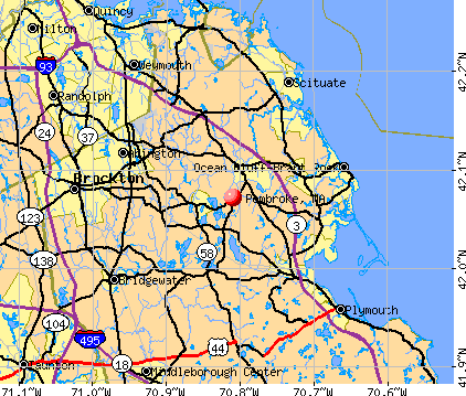
Pembroke, Massachusetts

Submit your own pictures of this town and show them to the world
- OSM Map
- General Map
- Google Map
- MSN Map
Population change since 2000: +5.4%
 |
| Males: 8,756 | |
| Females: 9,081 |
| Median resident age: | 40.8 years |
| Massachusetts median age: | 39.2 years |
Zip codes: 02359.
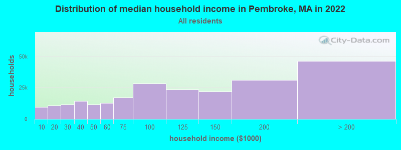
| Pembroke: | $120,676 |
| MA: | $94,488 |
Estimated per capita income in 2022: $59,138 (it was $27,066 in 2000)
Pembroke town income, earnings, and wages data
Estimated median house or condo value in 2022: $592,016 (it was $190,100 in 2000)
| Pembroke: | $592,016 |
| MA: | $534,700 |
Mean prices in 2022: all housing units: $585,203; detached houses: $620,100; townhouses or other attached units: $487,972; in 2-unit structures: $464,355; in 3-to-4-unit structures: $429,583; in 5-or-more-unit structures: $438,441; mobile homes: $207,706; occupied boats, rvs, vans, etc.: $17,153
Detailed information about poverty and poor residents in Pembroke, MA


Compare current foreclosures near Pembroke, MA:
| Photo | Address | Area | Beds / Baths | Price | Details |
|---|---|---|---|---|---|

|
#1
Silverwood Rd
Pembroke, MA 02359
|
2,493 sq. feet
|
2 baths 3 beds |
show details | |

|
#2
Washington St Apt B18
Pembroke, MA 02359
|
1,348 sq. feet
|
2 baths 2 beds |
show details | |

|
#3
Wampatuck St
Pembroke, MA 02359
|
1,760 sq. feet
|
2 baths 3 beds |
show details | |

|
#4
Center St
Pembroke, MA 02359
|
1,559 sq. feet
|
2 baths 3 beds |
show details | |

|
#5
Dwelley St
Pembroke, MA 02359
|
3,165 sq. feet
|
2 baths 4 beds |
show details | |

|
#6
Warren Ter
Pembroke, MA 02359
|
3,757 sq. feet
|
3 baths 5 beds |
show details | |

|
#7
School St
Pembroke, MA 02359
|
690 sq. feet
|
1 baths 1 beds |
show details | |

|
#8
Pleasant St
Pembroke, MA 02359
|
960 sq. feet
|
1 baths 3 beds |
show details | |

|
#9
High St
Pembroke, MA 02359
|
1,296 sq. feet
|
1 baths - beds |
show details | |

|
#10
Schoosett St
Pembroke, MA 02359
|
1,092 sq. feet
|
1 baths - beds |
show details |
| Photo | Address | Area | Beds / Baths | Price | Details |
|---|---|---|---|---|---|

|
#11
W Elm St
Pembroke, MA 02359
|
1,230 sq. feet
|
1 baths - beds |
show details | |

|
#12
Gorham Ave
Pembroke, MA 02359
|
1,167 sq. feet
|
1 baths - beds |
show details | |

|
#13
Deveuve Ln
Pembroke, MA 02359
|
1,290 sq. feet
|
2 baths - beds |
show details | |

|
#14
Chapel St
Pembroke, MA 02359
|
1,900 sq. feet
|
1 baths - beds |
show details | |

|
#15
Barker St
Pembroke, MA 02359
|
3,342 sq. feet
|
2 baths - beds |
show details | |

|
#16
Oldham St
Pembroke, MA 02359
|
2,782 sq. feet
|
1 baths - beds |
show details | |

|
#17
Plain St
Pembroke, MA 02359
|
1,724 sq. feet
|
1 baths - beds |
show details | |

|
#18
Catherine Rd
Pembroke, MA 02359
|
1,600 sq. feet
|
2 baths - beds |
show details | |

|
#19
Deerfield Ln
Pembroke, MA 02359
|
- sq. feet
|
- baths - beds |
show details | |

|
#20
Corporate Park Dr Ste 240
Pembroke, MA 02359
|
- sq. feet
|
- baths - beds |
show details |
| Photo | Address | Area | Beds / Baths | Price | Details |
|---|---|---|---|---|---|

|
#21
Pembroke Woods Dr
Pembroke, MA 02359
|
- sq. feet
|
- baths - beds |
show details | |

|
#22
Washington St Apt B-18
Pembroke, MA 02359
|
- sq. feet
|
- baths - beds |
show details | |

|
#23
Evan Rd
Pembroke, MA 02359
|
- sq. feet
|
- baths - beds |
show details | |

|
#24
Glenwood Rd
Pembroke, MA 02359
|
- sq. feet
|
- baths - beds |
show details | |

|
#25
Oak St Ste 2
Pembroke, MA 02359
|
- sq. feet
|
- baths - beds |
show details | |

|
#26
Tall Oaks Dr Unit 508
South Weymouth, MA 02190
|
1,300 sq. feet
|
2 baths 2 beds |
$285,000
|
show details |

|
#27
Prospect St
Norwell, MA 02061
|
5,483 sq. feet
|
5 baths 5 beds |
$1,760,000
|
show details |

|
#28
Bedford St Apt C-2
Whitman, MA 02382
|
1,610 sq. feet
|
2 baths 2 beds |
show details | |

|
#29
Skyline Dr Apt 2
Braintree, MA 02184
|
535 sq. feet
|
1 baths 1 beds |
show details | |

|
#30
Hillside Rd
Hull, MA 02045
|
1,664 sq. feet
|
2 baths 4 beds |
show details |
| Photo | Address | Area | Beds / Baths | Price | Details |
|---|---|---|---|---|---|

|
#31
Douglas Ave
Norwell, MA 02061
|
740 sq. feet
|
1 baths 3 beds |
show details | |

|
#32
Round Hill Rd
Kingston, MA 02364
|
2,698 sq. feet
|
3 baths 4 beds |
show details | |

|
#33
South St
Bridgewater, MA 02324
|
2,817 sq. feet
|
2 baths 3 beds |
show details | |

|
#34
N Main St Unit 7
Brockton, MA 02301
|
945 sq. feet
|
2 baths 2 beds |
show details | |

|
#35
Ferry St
Marshfield, MA 02050
|
979 sq. feet
|
1 baths 3 beds |
show details | |

|
#36
Isabel Cir
Randolph, MA 02368
|
1,068 sq. feet
|
1 baths 3 beds |
show details | |

|
#37
Hampton Cir
Hull, MA 02045
|
772 sq. feet
|
1 baths 1 beds |
show details | |

|
#38
Bedford St
Whitman, MA 02382
|
2,024 sq. feet
|
3 baths 3 beds |
show details | |

|
#39
Brunswick St
Marshfield, MA 02050
|
760 sq. feet
|
1 baths 2 beds |
show details | |

|
#40
Hollis Ave
Braintree, MA 02184
|
2,664 sq. feet
|
3 baths 5 beds |
show details |
| Photo | Address | Area | Beds / Baths | Price | Details |
|---|---|---|---|---|---|

|
#41
Court St # 1
Whitman, MA 02382
|
1,620 sq. feet
|
3 baths 3 beds |
show details | |

|
#42
Hughes St
Plymouth, MA 02360
|
1,286 sq. feet
|
1 baths 3 beds |
show details | |

|
#43
Jacqueline Ln
Plymouth, MA 02360
|
2,118 sq. feet
|
1 baths 4 beds |
show details | |

|
#44
Tamarack Ln
Abington, MA 02351
|
1,495 sq. feet
|
2 baths 2 beds |
show details | |

|
#45
Wareham St
Middleboro, MA 02346
|
1,114 sq. feet
|
1 baths 1 beds |
show details | |

|
#46
Prospect St
Stoughton, MA 02072
|
1,620 sq. feet
|
2 baths 2 beds |
show details | |

|
#47
Howard Ave
Holbrook, MA 02343
|
1,181 sq. feet
|
2 baths 2 beds |
show details | |

|
#48
2nd St
Hull, MA 02045
|
1,624 sq. feet
|
1 baths 4 beds |
show details | |

|
#49
Wareham St
Middleboro, MA 02346
|
912 sq. feet
|
1 baths 2 beds |
show details | |

|
Check over 1 million property listings on Foreclosure.com!
|
browse all offers | |||

- 17,13896.1%White alone
- 1931.1%Hispanic
- 1670.9%Asian alone
- 1640.9%Two or more races
- 1050.6%Black alone
- 430.2%Other race alone
- 240.1%American Indian alone
- 30.02%Native Hawaiian and Other
Pacific Islander alone
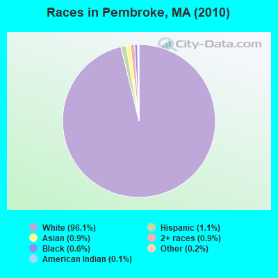
Races in Pembroke detailed stats: ancestries, foreign born residents, place of birth
According to our research of Massachusetts and other state lists, there were 4 registered sex offenders living in Pembroke, Massachusetts as of June 15, 2024.
The ratio of all residents to sex offenders in Pembroke is 4,459 to 1.
The ratio of registered sex offenders to all residents in this city is much lower than the state average.
Type |
2009 |
2010 |
2011 |
2012 |
2013 |
2014 |
2015 |
2016 |
2017 |
2018 |
2019 |
2020 |
2021 |
2022 |
|---|---|---|---|---|---|---|---|---|---|---|---|---|---|---|
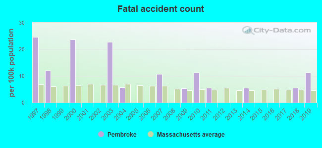
| Murders (per 100,000) | 0 (0.0) | 0 (0.0) | 0 (0.0) | 0 (0.0) | 0 (0.0) | 0 (0.0) | 0 (0.0) | 0 (0.0) | 0 (0.0) | 0 (0.0) | 0 (0.0) | 0 (0.0) | 0 (0.0) | 0 (0.0) |
| Rapes (per 100,000) | 2 (10.5) | 2 (11.2) | 8 (44.6) | 2 (11.1) | 2 (11.1) | 3 (16.5) | 2 (10.9) | 1 (5.5) | 2 (10.8) | 5 (27.1) | 2 (10.9) | 1 (5.2) | 3 (15.4) | 5 (25.9) |
| Robberies (per 100,000) | 8 (42.2) | 3 (16.8) | 4 (22.3) | 1 (5.5) | 3 (16.6) | 4 (22.0) | 1 (5.5) | 1 (5.5) | 0 (0.0) | 0 (0.0) | 3 (16.3) | 1 (5.2) | 0 (0.0) | 1 (5.2) |
| Assaults (per 100,000) | 21 (110.7) | 27 (151.4) | 27 (150.5) | 19 (105.0) | 28 (155.2) | 23 (126.3) | 20 (109.4) | 16 (87.6) | 10 (54.2) | 11 (59.6) | 8 (43.5) | 13 (67.7) | 7 (35.9) | 10 (51.8) |
| Burglaries (per 100,000) | 55 (290.0) | 87 (487.8) | 57 (317.6) | 46 (254.2) | 38 (210.6) | 18 (98.9) | 27 (147.7) | 25 (136.8) | 11 (59.6) | 8 (43.4) | 12 (65.3) | 5 (26.0) | 3 (15.4) | 4 (20.7) |
| Thefts (per 100,000) | 123 (648.5) | 184 (1,032) | 178 (991.9) | 159 (878.7) | 114 (631.9) | 105 (576.7) | 80 (437.5) | 68 (372.1) | 91 (493.1) | 76 (412.0) | 60 (326.5) | 48 (249.9) | 42 (215.3) | 40 (207.4) |
| Auto thefts (per 100,000) | 12 (63.3) | 11 (61.7) | 12 (66.9) | 13 (71.8) | 7 (38.8) | 7 (38.4) | 4 (21.9) | 13 (71.1) | 5 (27.1) | 3 (16.3) | 8 (43.5) | 5 (26.0) | 5 (25.6) | 1 (5.2) |
| Arson (per 100,000) | 0 (0.0) | 2 (11.2) | 0 (0.0) | 0 (0.0) | 0 (0.0) | 1 (5.5) | 0 (0.0) | 1 (5.5) | 1 (5.4) | 0 (0.0) | 1 (5.4) | 1 (5.2) | 0 (0.0) | 0 (0.0) |
| City-Data.com crime index | 94.5 | 124.6 | 139.7 | 90.2 | 88.0 | 78.1 | 61.9 | 53.7 | 45.6 | 54.4 | 43.4 | 33.2 | 31.2 | 42.8 |
The City-Data.com crime index weighs serious crimes and violent crimes more heavily. Higher means more crime, U.S. average is 246.1. It adjusts for the number of visitors and daily workers commuting into cities.
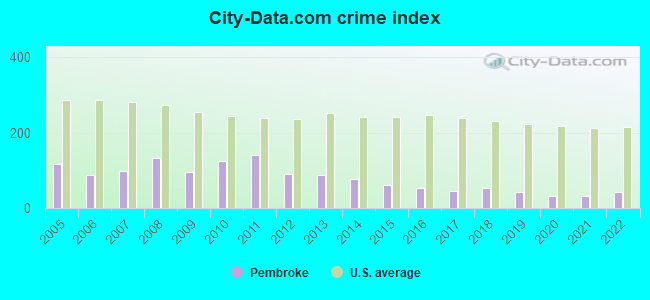
Crime rate in Pembroke detailed stats: murders, rapes, robberies, assaults, burglaries, thefts, arson
Full-time law enforcement employees in 2021, including police officers: 32 (30 officers - 27 male; 3 female).
| Officers per 1,000 residents here: | 1.54 |
| Massachusetts average: | 2.53 |
 Recent articles from our blog. Our writers, many of them Ph.D. graduates or candidates, create easy-to-read articles on a wide variety of topics.

 | Nicer house in Pembroke or hold out for Norwell scituate duxbury? (72 replies) |
| 2023 Real Estate Observations (5278 replies) |
| 2021 Real Estate Observations (1729 replies) |
| When is the insanity going to end? There has to be a real estate market crash, right? (99 replies) |
| What's wrong with Marshfield? (110 replies) |
| Is waiting for home prices to come down pointless? (148 replies) |
Latest news from Pembroke, MA collected exclusively by city-data.com from local newspapers, TV, and radio stations
Ancestries: Irish (41.3%), Italian (17.8%), English (14.9%), German (6.8%), French (5.3%), Scottish (4.2%).
Current Local Time: EST time zone
Incorporated in 1712
Elevation: 70 feet
Land area: 21.8 square miles.
Population density: 817 people per square mile (low).
340 residents are foreign born (1.1% Europe, 0.6% Asia).
| This town: | 2.0% |
| Massachusetts: | 12.2% |
| Pembroke town: | 1.3% ($2,428) |
| Massachusetts: | 1.3% ($2,336) |
Nearest city with pop. 50,000+: Brockton, MA  (11.2 miles , pop. 94,304).
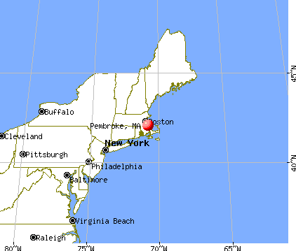
Nearest city with pop. 200,000+: Boston, MA (23.0 miles , pop. 589,141).
Nearest city with pop. 1,000,000+: Bronx, NY (180.0 miles , pop. 1,332,650).
Nearest cities:
), ), )Latitude: 42.07 N, Longitude: 70.80 W

Pembroke, Massachusetts accommodation & food services, waste management - Economy and Business Data
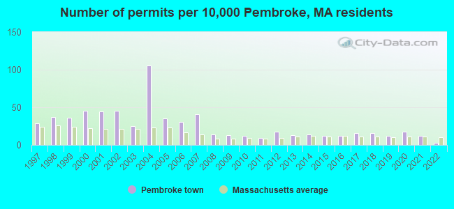
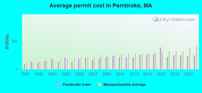
Single-family new house construction building permits:
- 2022: 5 buildings, average cost: $252,700
- 2021: 20 buildings, average cost: $243,100
- 2020: 30 buildings, average cost: $256,600
- 2019: 21 buildings, average cost: $255,800
- 2018: 27 buildings, average cost: $224,100
- 2017: 27 buildings, average cost: $395,000
- 2016: 21 buildings, average cost: $271,000
- 2015: 21 buildings, average cost: $273,100
- 2014: 24 buildings, average cost: $264,400
- 2013: 22 buildings, average cost: $222,100
- 2012: 30 buildings, average cost: $214,800
- 2011: 15 buildings, average cost: $224,900
- 2010: 21 buildings, average cost: $240,700
- 2009: 22 buildings, average cost: $227,400
- 2008: 23 buildings, average cost: $206,900
- 2007: 69 buildings, average cost: $169,100
- 2006: 52 buildings, average cost: $214,900
- 2005: 60 buildings, average cost: $196,800
- 2004: 180 buildings, average cost: $145,700
- 2003: 43 buildings, average cost: $215,800
- 2002: 76 buildings, average cost: $139,700
- 2001: 75 buildings, average cost: $195,800
- 2000: 77 buildings, average cost: $153,000
- 1999: 61 buildings, average cost: $125,400
- 1998: 63 buildings, average cost: $143,700
- 1997: 49 buildings, average cost: $100,800
| Here: | 3.3% |
| Massachusetts: | 3.5% |
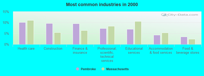
- Health care (10.1%)
- Construction (9.6%)
- Finance & insurance (9.6%)
- Professional, scientific, technical services (7.3%)
- Educational services (7.0%)
- Accommodation & food services (4.3%)
- Food & beverage stores (3.5%)
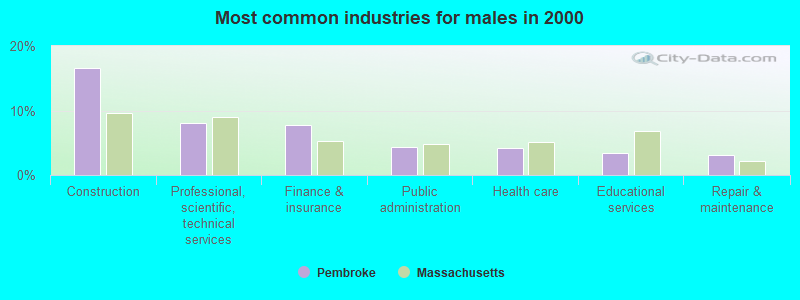
- Construction (16.6%)
- Professional, scientific, technical services (8.1%)
- Finance & insurance (7.7%)
- Public administration (4.4%)
- Health care (4.1%)
- Educational services (3.4%)
- Repair & maintenance (3.2%)
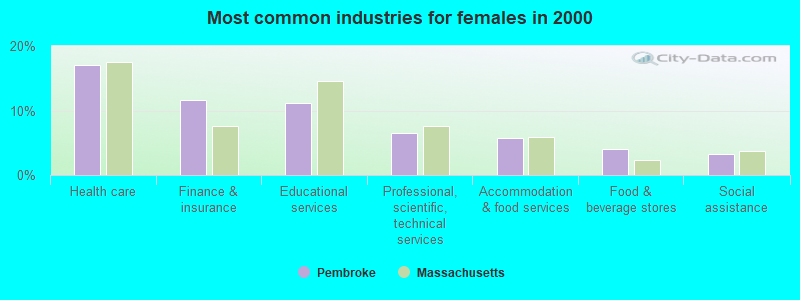
- Health care (17.1%)
- Finance & insurance (11.7%)
- Educational services (11.2%)
- Professional, scientific, technical services (6.4%)
- Accommodation & food services (5.7%)
- Food & beverage stores (4.1%)
- Social assistance (3.2%)
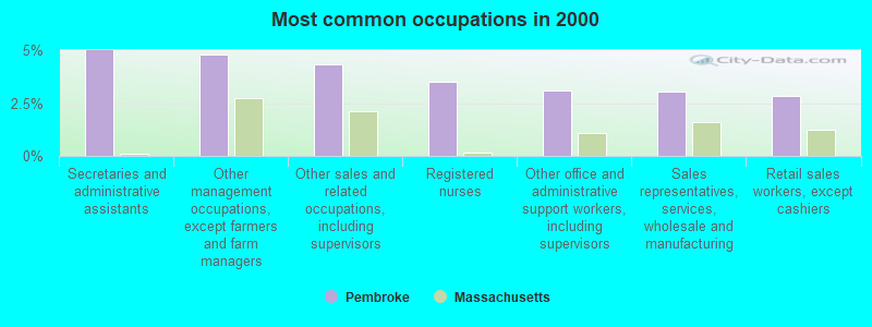
- Secretaries and administrative assistants (5.0%)
- Other management occupations, except farmers and farm managers (4.8%)
- Other sales and related occupations, including supervisors (4.4%)
- Registered nurses (3.5%)
- Other office and administrative support workers, including supervisors (3.1%)
- Sales representatives, services, wholesale and manufacturing (3.1%)
- Retail sales workers, except cashiers (2.8%)
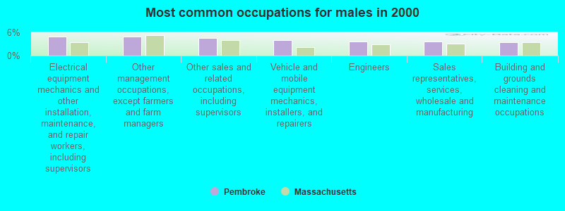
- Electrical equipment mechanics and other installation, maintenance, and repair workers, including supervisors (4.9%)
- Other management occupations, except farmers and farm managers (4.8%)
- Other sales and related occupations, including supervisors (4.5%)
- Vehicle and mobile equipment mechanics, installers, and repairers (4.0%)
- Engineers (3.6%)
- Sales representatives, services, wholesale and manufacturing (3.6%)
- Building and grounds cleaning and maintenance occupations (3.4%)

- Secretaries and administrative assistants (10.2%)
- Registered nurses (7.0%)
- Other office and administrative support workers, including supervisors (5.8%)
- Preschool, kindergarten, elementary, and middle school teachers (4.9%)
- Other management occupations, except farmers and farm managers (4.8%)
- Other sales and related occupations, including supervisors (4.2%)
- Waiters and waitresses (4.0%)
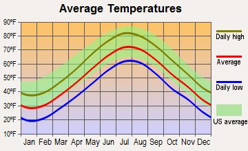
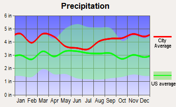
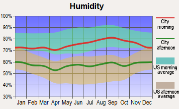
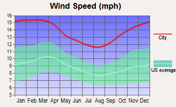
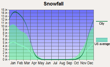
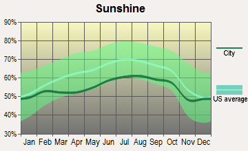
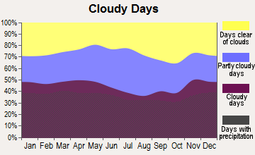
Average climate in Pembroke, Massachusetts
Based on data reported by over 4,000 weather stations
(lower is better)
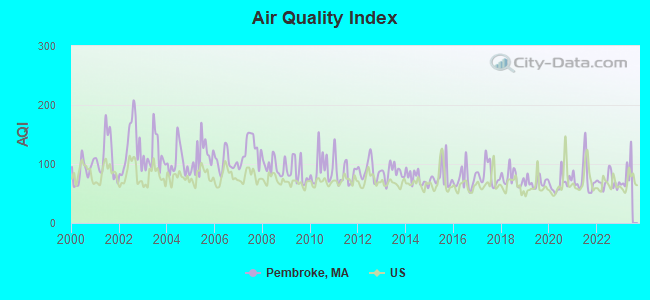
Air Quality Index (AQI) level in 2022 was 70.0. This is about average.
| City: | 70.0 |
| U.S.: | 72.6 |
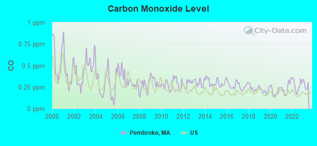
Carbon Monoxide (CO) [ppm] level in 2022 was 0.269. This is about average. Closest monitor was 15.1 miles away from the city center.
| City: | 0.269 |
| U.S.: | 0.251 |
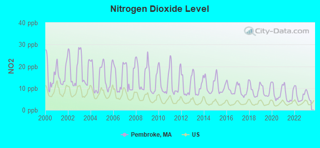
Nitrogen Dioxide (NO2) [ppb] level in 2022 was 6.54. This is worse than average. Closest monitor was 10.5 miles away from the city center.
| City: | 6.54 |
| U.S.: | 5.11 |
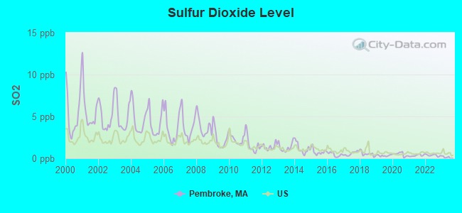
Sulfur Dioxide (SO2) [ppb] level in 2022 was 0.358. This is significantly better than average. Closest monitor was 10.5 miles away from the city center.
| City: | 0.358 |
| U.S.: | 1.515 |
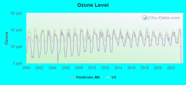
Ozone [ppb] level in 2022 was 30.2. This is about average. Closest monitor was 10.7 miles away from the city center.
| City: | 30.2 |
| U.S.: | 33.3 |
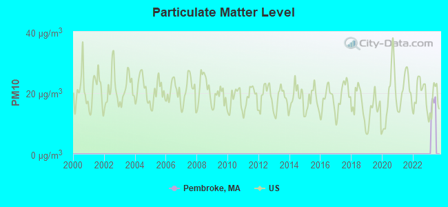
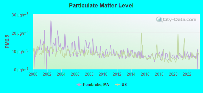
Particulate Matter (PM2.5) [µg/m3] level in 2022 was 7.45. This is about average. Closest monitor was 10.7 miles away from the city center.
| City: | 7.45 |
| U.S.: | 8.11 |
Tornado activity:
Pembroke-area historical tornado activity is below Massachusetts state average. It is 62% smaller than the overall U.S. average.
On 6/9/1953, a category F4 (max. wind speeds 207-260 mph) tornado 40.1 miles away from the Pembroke town center killed 90 people and injured 1228 people and caused between $50,000,000 and $500,000,000 in damages.
On 6/9/1953, a category F3 (max. wind speeds 158-206 mph) tornado 20.4 miles away from the town center injured 17 people and caused between $500,000 and $5,000,000 in damages.
Earthquake activity:
Pembroke-area historical earthquake activity is significantly above Massachusetts state average. It is 75% smaller than the overall U.S. average.On 10/7/1983 at 10:18:46, a magnitude 5.3 (5.1 MB, 5.3 LG, 5.1 ML, Class: Moderate, Intensity: VI - VII) earthquake occurred 221.5 miles away from Pembroke center
On 4/20/2002 at 10:50:47, a magnitude 5.3 (5.3 ML, Depth: 3.0 mi) earthquake occurred 223.3 miles away from Pembroke center
On 10/16/2012 at 23:12:25, a magnitude 4.7 (4.7 ML, Depth: 10.0 mi, Class: Light, Intensity: IV - V) earthquake occurred 106.2 miles away from Pembroke center
On 1/19/1982 at 00:14:42, a magnitude 4.7 (4.5 MB, 4.7 MD, 4.5 LG) earthquake occurred 107.1 miles away from the city center
On 4/20/2002 at 10:50:47, a magnitude 5.2 (5.2 MB, 4.2 MS, 5.2 MW, 5.0 MW) earthquake occurred 222.6 miles away from the city center
On 8/22/1992 at 12:20:32, a magnitude 4.8 (4.8 MB, 3.8 MS, 4.7 LG, Depth: 6.2 mi) earthquake occurred 206.3 miles away from Pembroke center
Magnitude types: regional Lg-wave magnitude (LG), body-wave magnitude (MB), duration magnitude (MD), local magnitude (ML), surface-wave magnitude (MS), moment magnitude (MW)
Natural disasters:
The number of natural disasters in Plymouth County (26) is a lot greater than the US average (15).Major Disasters (Presidential) Declared: 17
Emergencies Declared: 9
Causes of natural disasters: Floods: 11, Storms: 9, Hurricanes: 7, Snows: 3, Snowstorms: 3, Blizzards: 2, Winter Storms: 2, Heavy Rain: 1, Snowfall: 1, Tropical Storm: 1, Wind: 1 (Note: some incidents may be assigned to more than one category).
Hospitals and medical centers in Pembroke:
Airports located in Pembroke:
- Pheasant Field Airport (MA64) (Runways: 1)
- Sherman-Pvt Airport (MA63) (Runways: 1)
Operable nuclear power plant near Pembroke:
- 11 miles: Pilgrim in Plymouth, MA.
Colleges/universities with over 2000 students nearest to Pembroke:
- Massasoit Community College (about 10 miles; Brockton, MA; Full-time enrollment: 5,442)
- Bridgewater State University (about 10 miles; Bridgewater, MA; FT enrollment: 9,802)
- Stonehill College (about 15 miles; Easton, MA; FT enrollment: 2,563)
- Quincy College (about 17 miles; Quincy, MA; FT enrollment: 3,184)
- Curry College (about 20 miles; Milton, MA; FT enrollment: 2,586)
- University of Massachusetts-Boston (about 21 miles; Boston, MA; FT enrollment: 12,625)
- Northeastern University (about 24 miles; Boston, MA; FT enrollment: 27,758)
Public high school in Pembroke:
- PEMBROKE HIGH SCHOOL (Students: 863, Location: 80 LEARNING LANE, Grades: 9-12)
Public elementary/middle schools in Pembroke:
- NORTH PEMBROKE ELEMENTARY (Students: 708, Location: 72 PILGRIM ROAD, Grades: PK-6)
- HOBOMOCK ELEMENTARY (Students: 689, Location: 81 LEARNING LANE, Grades: KG-6)
- BRYANTVILLE ELEMENTARY (Students: 586, Location: 29 GURNEY DRIVE, Grades: KG-6)
- PEMBROKE COMMUNITY MIDDLE SCHOOL (Students: 507, Location: 559 SCHOOL STREET, Grades: 7-8)
Library in Pembroke:
- PEMBROKE PUBLIC LIBRARY (Operating income: $584,537; Location: 142 CENTER ST.; 73,436 books; 523 e-books; 5,830 audio materials; 3,985 video materials; 3 local licensed databases; 34 state licensed databases; 1 other licensed databases; 187 print serial subscriptions; 1 electronic serial subscriptions)
Points of interest:
Notable locations in Pembroke: Pembroke Country Club (A), Pembroke Fire Department Station 2 (B), Pembroke Fire Department Station 3 (C), Pembroke Fire Department Station 1 (D), Pembroke Fire Department Headquarters (E), Arnold Hall (F), Hobomock Arena (G), Pembroke Town Hall (H). Display/hide their locations on the map
Shopping Centers: Pembroke Shopping Center (1), North River Plaza Shopping Center (2). Display/hide their locations on the map
Churches in Pembroke include: Plymouth Bay Church (A), Marshfield United Methodist Church (B), High Street United Methodist Church (C), First Church in Pembroke (D), Bryantsville United Methodist Church (E), Pilgrim Chapel (F), First Baptist Church (G). Display/hide their locations on the map
Cemeteries: Sachem Lodge Cemetery (1), Pine Grove Cemetery (2), Briggs Cemetery (3), Schoosett Cemetery (4). Display/hide their locations on the map
Lakes, reservoirs, and swamps: Factory Pond (A), Furnace Pond (B), Great Sandy Bottom Pond (C), Hobomock Pond (D), Howard Pond (E), Little Sandy Bottom Pond (F), No Bottom Pond (G), Oldham Pond (H). Display/hide their locations on the map
Streams, rivers, and creeks: Tubbs Meadow Brook (A), Third Herring Brook (B), Swamp Brook (C), Robinson Creek (D), Pudding Brook (E), McFarland Brook (F), Indian Head River (G), Huldah Brook (H), Queen Brook (I). Display/hide their locations on the map
Tourist attraction: Pembroke Historical Society (Historical Places & Services; 116 Center Street) (1). Display/hide its approximate location on the map
Birthplace of: Buddy Teevens - Football player and coach, Ben Edlund - Artist, Eric Flaim - Speed skater, Joseph Leavitt - Farmer, Thomas Humphrey Cushing - Adjutant General of the Army and Inspector General of the Army, Duane Joyce - Ice hockey player, Josiah Smith - Politician, Peter Metcalf (ice hockey) - Ice hockey player, Tom Hanlon - College football player (Brown Bears), Pat Seltsam - Speed skater.
Drinking water stations with addresses in Pembroke and their reported violations in the past:
PEMBROKE WATER DIVISION DPW (Population served: 19,265, Groundwater):Past health violations:Past monitoring violations:
- MCL, Monthly (TCR) - In SEP-2013, Contaminant: Coliform. Follow-up actions: St AO (w/o penalty) issued (NOV-29-2013), St Compliance achieved (NOV-29-2013)
- MCL, Monthly (TCR) - In NOV-2011, Contaminant: Coliform. Follow-up actions: St AO (w/o penalty) issued (JAN-31-2012), St Compliance achieved (JAN-31-2012)
- MCL, Monthly (TCR) - In SEP-2010, Contaminant: Coliform. Follow-up actions: St Compliance achieved (NOV-08-2010)
- MCL, Monthly (TCR) - In AUG-2010, Contaminant: Coliform. Follow-up actions: St AO (w/o penalty) issued (NOV-08-2010), St Compliance achieved (NOV-08-2010)
- MCL, Monthly (TCR) - In AUG-2008, Contaminant: Coliform. Follow-up actions: St AO (w/o penalty) issued (AUG-12-2008)
- MCL, Acute (TCR) - In AUG-2008, Contaminant: Coliform. Follow-up actions: St AO (w/o penalty) issued (AUG-12-2008)
- 2 other older health violations
- Notification, State - In NOV-2011, Contaminant: Coliform (TCR). Follow-up actions: St AO (w/o penalty) issued (JAN-31-2012), St Compliance achieved (JAN-31-2012)
- Notification, State - In AUG-2010, Contaminant: Coliform (TCR). Follow-up actions: St AO (w/o penalty) issued (NOV-08-2010), St Compliance achieved (NOV-08-2010), St AO (w/o penalty) issued (NOV-08-2010)
- Notification, State - In SEP-2006, Contaminant: Coliform (TCR). Follow-up actions: St AO (w/o penalty) issued (MAY-16-2007), St Compliance achieved (MAY-16-2007)
- One minor monitoring violation
| This town: | 2.8 people |
| Massachusetts: | 2.5 people |
| This town: | 75.7% |
| Whole state: | 63.0% |
| This town: | 6.5% |
| Whole state: | 7.0% |
Likely homosexual households (counted as self-reported same-sex unmarried-partner households)
- Lesbian couples: 0.6% of all households
- Gay men: 0.4% of all households
| This town: | 4.8% |
| Whole state: | 9.3% |
| This town: | 2.2% |
| Whole state: | 4.4% |
People in group quarters in Pembroke in 2000:
- 68 people in homes for the mentally retarded
- 57 people in mental (psychiatric) hospitals or wards
- 2 people in religious group quarters
Banks with branches in Pembroke (2011 data):
- Sovereign Bank, National Association: Pembroke Shopping Center Branch at 175 Centre Street, branch established on 1977/11/30. Info updated 2012/01/31: Bank assets: $78,146.9 mil, Deposits: $48,042.9 mil, headquarters in Wilmington, DE, positive income, Commercial Lending Specialization, 718 total offices, Holding Company: Banco Santander, S.A.
- Rockland Trust Company: Pembroke Branch at 147 Center St, branch established on 1968/06/06. Info updated 2009/05/20: Bank assets: $4,974.4 mil, Deposits: $3,903.9 mil, headquarters in Rockland, MA, positive income, Commercial Lending Specialization, 67 total offices, Holding Company: Independent Bank Corp.
- South Shore Savings Bank: Pembroke Branch at 75 Washington Street, branch established on 2006/06/19. Info updated 2011/08/26: Bank assets: $950.4 mil, Deposits: $661.6 mil, headquarters in South Weymouth, MA, positive income, Commercial Lending Specialization, 13 total offices, Holding Company: South Shore Bancorp Mhc
- RBS Citizens, National Association: Pembroke Stop & Shop Branch at North River Plaza Rt.139, branch established on 2002/04/03. Info updated 2007/09/19: Bank assets: $106,940.6 mil, Deposits: $75,690.2 mil, headquarters in Providence, RI, positive income, 1135 total offices, Holding Company: Uk Financial Investments Limited
- Bridgewater Savings Bank: Pembroke Branch at Mattakeesett And Center Streets, branch established on 1959/05/18. Info updated 2010/02/03: Bank assets: $491.1 mil, Deposits: $376.9 mil, headquarters in Raynham, MA, positive income, Commercial Lending Specialization, 10 total offices, Holding Company: Bridgewater Financial, Mhc
For population 15 years and over in Pembroke:
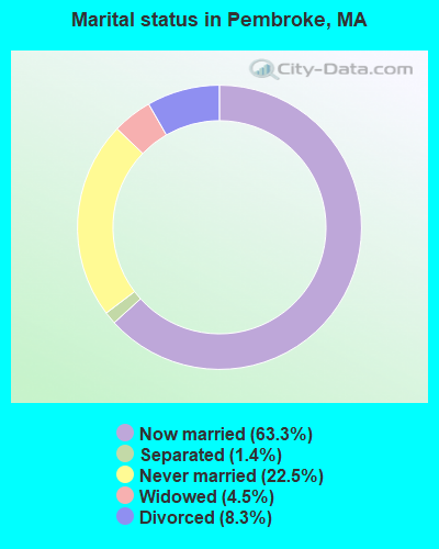
- Never married: 22.5%
- Now married: 63.3%
- Separated: 1.4%
- Widowed: 4.5%
- Divorced: 8.3%
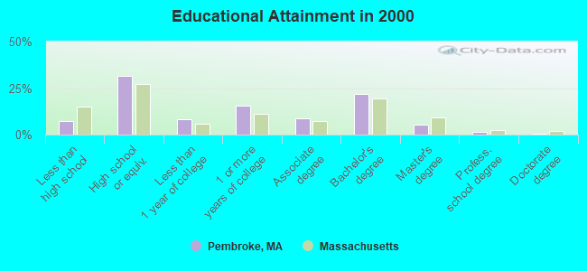
For population 25 years and over in Pembroke:
- High school or higher: 92.9%
- Bachelor's degree or higher: 28.5%
- Graduate or professional degree: 6.7%
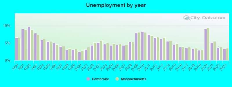
- Unemployed: 3.1%
- Mean travel time to work (commute): 35.8 minutes
| Here: | 9.2 |
| Massachusetts average: | 13.1 |


Graphs represent county-level data. Detailed 2008 Election Results
Religion statistics for Pembroke, MA (based on Plymouth County data)


| Religion | Adherents | Congregations |
|---|---|---|
| Catholic | 165,985 | 35 |
| Mainline Protestant | 23,724 | 91 |
| Evangelical Protestant | 13,159 | 96 |
| Other | 6,129 | 43 |
| Orthodox | 1,140 | 3 |
| Black Protestant | 611 | 5 |
| None | 284,171 | - |
Food Environment Statistics:
| This county: | 1.74 / 10,000 pop. |
| State: | 1.98 / 10,000 pop. |
| Plymouth County: | 0.04 / 10,000 pop. |
| Massachusetts: | 0.05 / 10,000 pop. |
| Plymouth County: | 2.84 / 10,000 pop. |
| Massachusetts: | 2.22 / 10,000 pop. |
| Plymouth County: | 2.20 / 10,000 pop. |
| State: | 1.77 / 10,000 pop. |
| Plymouth County: | 7.37 / 10,000 pop. |
| Massachusetts: | 8.76 / 10,000 pop. |
| Plymouth County: | 7.9% |
| State: | 8.1% |
| This county: | 21.7% |
| State: | 22.5% |
| Plymouth County: | 16.3% |
| Massachusetts: | 16.5% |
5.54% of this county's 2020 resident taxpayers moved to other counties in 2021 ($85,482 average adjusted gross income)
| Here: | 5.54% |
| Massachusetts average: | 7.18% |
0.01% of residents moved to foreign countries ($80 average AGI)
Plymouth County: 0.01% Massachusetts average: 0.02%
Top counties to which taxpayers relocated from this county between 2020 and 2021:
| to Bristol County, MA | |
| to Norfolk County, MA | |
| to Suffolk County, MA |
| Businesses in Pembroke, MA | ||||
| Name | Count | Name | Count | |
|---|---|---|---|---|
| 7-Eleven | 1 | Kohl's | 1 | |
| Ace Hardware | 1 | Lowe's | 1 | |
| Burger King | 1 | MasterBrand Cabinets | 7 | |
| CVS | 1 | Nike | 3 | |
| DressBarn | 1 | Payless | 1 | |
| Dunkin Donuts | 4 | Staples | 1 | |
| FedEx | 4 | Stop & Shop | 2 | |
| H&R Block | 1 | UPS | 6 | |
Strongest AM radio stations in Pembroke:
- WBZ (1030 AM; 50 kW; BOSTON, MA; Owner: INFINITY BROADCASTING OPERATIONS, INC.)
- WEEI (850 AM; 50 kW; BOSTON, MA; Owner: ENTERCOM BOSTON LICENSE, LLC)
- WRKO (680 AM; 50 kW; BOSTON, MA; Owner: ENTERCOM BOSTON LICENSE, LLC)
- WPLM (1390 AM; 5 kW; PLYMOUTH, MA; Owner: PLYMOUTH ROCK BROADCASTING CO., INC.)
- WWZN (1510 AM; 50 kW; BOSTON, MA; Owner: ROSE CITY RADIO CORPORATION)
- WKOX (1200 AM; 50 kW; FRAMINGHAM, MA; Owner: CAPSTAR TX LIMITED PARTNERSHIP)
- WBIX (1060 AM; 40 kW; NATICK, MA; Owner: LANGER BROADCASTING CORPORATION)
- WALE (990 AM; 50 kW; GREENVILLE, RI; Owner: NORTH AMERICAN BROADCASTING CO., INC.)
- WAMG (890 AM; 25 kW; DEDHAM, MA; Owner: MEGA COMMUNICATIONS OF DEDHAM LICENSEE, LLC)
- WBET (1460 AM; 5 kW; BROCKTON, MA; Owner: KJI BROADCASTING, LLC)
- WUNR (1600 AM; 20 kW; BROOKLINE, MA; Owner: CHAMPION BROADCASTING SYSTEMS, INC.)
- WRCA (1330 AM; 25 kW; WALTHAM, MA; Owner: WRCA LICENSE, LLC)
- WCRN (830 AM; 50 kW; WORCESTER, MA; Owner: CARTER BROADCASTING CORPORATION)
Strongest FM radio stations in Pembroke:
- WATD-FM (95.9 FM; MARSHFIELD, MA; Owner: MARSHFIELD BROADCASTING CO., INC.)
- WPLM-FM (99.1 FM; PLYMOUTH, MA; Owner: PLYMOUTH ROCK BROADCASTING CO., INC.)
- WXKS-FM (107.9 FM; MEDFORD, MA; Owner: AMFM RADIO LICENSES, L.L.C.)
- WMJX (106.7 FM; BOSTON, MA; Owner: GREATER BOSTON RADIO, INC.)
- WBOT (97.7 FM; BROCKTON, MA; Owner: RADIO ONE LICENSES, LLC)
- WBMX (98.5 FM; BOSTON, MA; Owner: INFINITY RADIO OPERATIONS INC.)
- WBOS (92.9 FM; BROOKLINE, MA; Owner: GREATER BOSTON RADIO, INC.)
- WJMN (94.5 FM; BOSTON, MA; Owner: AMFM RADIO LICENSES, L.L.C.)
- WCRB (102.5 FM; WALTHAM, MA; Owner: CHARLES RIVER BROADCASTING WCRB LICE)
- WTKK (96.9 FM; BOSTON, MA; Owner: GREATER BOSTON RADIO, INC.)
- WROR-FM (105.7 FM; FRAMINGHAM, MA; Owner: GREATER BOSTON RADIO, INC.)
- WGBH (89.7 FM; BOSTON, MA; Owner: WGBH EDUCATIONAL FOUNDATION)
- WBUR-FM (90.9 FM; BOSTON, MA; Owner: TRUSTEES OF BOSTON UNIVERSITY)
- WBCN (104.1 FM; BOSTON, MA; Owner: HEMISPHERE BROADCASTING CORPORATION)
- WZLX (100.7 FM; BOSTON, MA; Owner: INFINITY BROADCASTING CORPORATION OF BOSTON)
- W267AI (101.3 FM; BOSTON, MA; Owner: MCC BROADCASTING COMPANY, INC.)
- WWBB (101.5 FM; PROVIDENCE, RI; Owner: CLEAR CHANNEL BROADCASTING LICENSES, INC.)
- WODS (103.3 FM; BOSTON, MA; Owner: INFINITY BROADCASTING OPERATIONS, INC.)
- WERS (88.9 FM; BOSTON, MA; Owner: EMERSON COLLEGE)
- WRPS (88.3 FM; ROCKLAND, MA; Owner: ROCKLAND PUBLIC SCHOOLS)
TV broadcast stations around Pembroke:
- WWDP (Channel 46; NORWELL, MA; Owner: NORWELL TELEVISION, LLC)
- WCVB-TV (Channel 5; BOSTON, MA; Owner: WCVB HEARST-ARGYLE TV, INC.)
- WGBH-TV (Channel 2; BOSTON, MA; Owner: WGBH EDUCATIONAL FOUNDATION)
- WHDH-TV (Channel 7; BOSTON, MA; Owner: WHDH-TV)
- WMFP (Channel 62; LAWRENCE, MA; Owner: WSAH LICENSE, INC.)
- WSBK-TV (Channel 38; BOSTON, MA; Owner: VIACOM INC.)
- WLVI-TV (Channel 56; CAMBRIDGE, MA; Owner: WLVI, INC.)
- WBZ-TV (Channel 4; BOSTON, MA; Owner: VIACOM INC.)
- WGBX-TV (Channel 44; BOSTON, MA; Owner: WGBH EDUCATIONAL FOUNDATION)
- WFXT (Channel 25; BOSTON, MA; Owner: FOX TELEVISION STATIONS INC.)
- WBPX (Channel 68; BOSTON, MA; Owner: PAXSON BOSTON-68 LICENSE, INC.)
- WLWC (Channel 28; NEW BEDFORD, MA; Owner: C-28 FCC LICENSEE SUBSIDIARY, LLC)
- WLNE-TV (Channel 6; NEW BEDFORD, MA; Owner: FREEDOM BROADCASTING OF SOUTHERN NEW ENGLAND, INC.)
- WTMU-LP (Channel 32; BOSTON, MA; Owner: ZGS BOSTON, INC.)
- WCEA-LP (Channel 58; BOSTON, MA; Owner: CHANNEL 19 TV CORPORATION)
- WPRI-TV (Channel 12; PROVIDENCE, RI; Owner: TVL BROADCASTING OF RHODE ISLAND, LLC)
- WNAC-TV (Channel 64; PROVIDENCE, RI; Owner: WNAC, LLC)
- W40BO (Channel 40; BOSTON, MA; Owner: PAXSON COMMUNICATIONS LPTV, INC.)
- WJAR (Channel 10; PROVIDENCE, RI; Owner: OUTLET BROADCASTING, INC.)
- WSBE-TV (Channel 36; PROVIDENCE, RI; Owner: RHODE ISLAND PUBLIC TELECOM. AUTHORITY)
- WUTF (Channel 66; MARLBOROUGH, MA; Owner: TELEFUTURA BOSTON LLC)
- WUNI (Channel 27; WORCESTER, MA; Owner: ENTRAVISION HOLDINGS, LLC)
- National Bridge Inventory (NBI) Statistics
- 2Number of bridges
- 33ft / 10.1mTotal length
- $8,596,000Total costs
- 62,623Total average daily traffic
- 6,888Total average daily truck traffic
- 186,358Total future (year 2031) average daily traffic
FCC Registered Antenna Towers:
34 (See the full list of FCC Registered Antenna Towers in Pembroke)FCC Registered Broadcast Land Mobile Towers:
11 (See the full list of FCC Registered Broadcast Land Mobile Towers in Pembroke, MA)FCC Registered Microwave Towers:
2- Pembroke, 171 Mattakeesett St (Lat: 42.063778 Lon: -70.824528), Type: Tower, Structure height: 50.3 m, Call Sign: WQIF542,
Assigned Frequencies: 10755.0 MHz, Grant Date: 01/24/2008, Expiration Date: 01/24/2018, Cancellation Date: 08/17/2015, Certifier: Pamelia Y Hoof, Registrant: Verizon Wireless, 1120 Sanctuary Pkwy, #150 Gasa5reg, Alpharetta, GA 30009-7630, Phone: (770) 797-1070, Fax: (770) 797-1036, Email:
- PEMBROKE, Lat: 42.071833 Lon: -70.809306, Call Sign: WQOS785,
Assigned Frequencies: 956.393 MHz, Grant Date: 12/16/2021, Expiration Date: 01/19/2032, Certifier: Gene Fulmine, Registrant: Business Radio Licensing, 30251 Golden Lantern, Suite E #501, Laguna Niguel, CA 92677, Phone: (949) 348-8510, Fax: (949) 348-8514, Email:
FCC Registered Amateur Radio Licenses:
72 (See the full list of FCC Registered Amateur Radio Licenses in Pembroke)FAA Registered Aircraft Manufacturers and Dealers:
2 (See the full list of FAA Registered Manufacturers and Dealers in Pembroke)FAA Registered Aircraft:
8 (See the full list of FAA Registered Aircraft)2002 - 2018 National Fire Incident Reporting System (NFIRS) incidents
- Fire incident types reported to NFIRS in Pembroke, MA
- 16655.9%Structure Fires
- 8930.0%Mobile Property/Vehicle Fires
- 227.4%Outside Fires
- 206.7%Other
 Based on the data from the years 2002 - 2018 the average number of fires per year is 17. The highest number of reported fires - 46 took place in 2002, and the least - 5 in 2017. The data has a dropping trend.
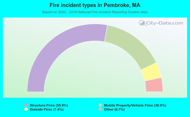 When looking into fire subcategories, the most incidents belonged to: Structure Fires (55.9%), and Mobile Property/Vehicle Fires (30.0%).
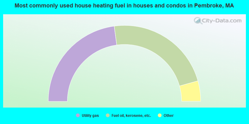
- 45.7%Utility gas
- 45.6%Fuel oil, kerosene, etc.
- 3.9%Bottled, tank, or LP gas
- 2.9%Electricity
- 0.8%Wood
- 0.6%Coal or coke
- 0.5%Other fuel
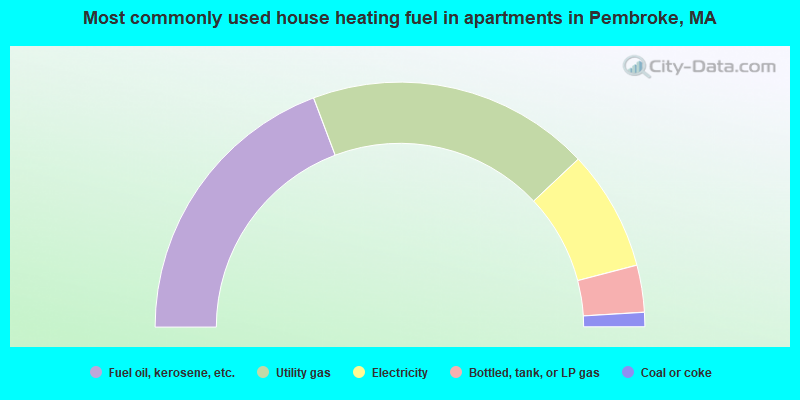
- 38.5%Fuel oil, kerosene, etc.
- 37.4%Utility gas
- 15.9%Electricity
- 6.2%Bottled, tank, or LP gas
- 1.9%Coal or coke
Pembroke compared to Massachusetts state average:
- Unemployed percentage significantly below state average.
- Black race population percentage significantly below state average.
- Hispanic race population percentage significantly below state average.
- Foreign-born population percentage significantly below state average.
- Renting percentage significantly below state average.
- Length of stay since moving in significantly above state average.
- Number of rooms per house significantly below state average.
- House age significantly below state average.
Pembroke on our top lists:
- #49 on the list of "Top 101 cities with largest percentage of females in occupations: secretaries and administrative assistants (population 5,000+)"
- #57 on the list of "Top 101 cities with largest percentage of males in industries: u. s. postal service (population 5,000+)"
- #67 on the list of "Top 101 cities with largest percentage of females in industries: clothing and accessories, including shoe, stores (population 5,000+)"
- #68 on the list of "Top 101 cities with largest percentage of females in occupations: registered nurses (population 5,000+)"
- #75 on the list of "Top 101 cities with largest percentage of females in occupations: air transportation workers (population 5,000+)"
- #82 on the list of "Top 101 cities with largest percentage of males in occupations: secretaries and administrative assistants (population 5,000+)"
- #85 on the list of "Top 101 cities with largest percentage of males in occupations: cashiers (population 5,000+)"
- #87 on the list of "Top 101 cities with largest percentage of males in industries: electronic shopping and mail-order houses (population 5,000+)"
- #88 on the list of "Top 101 cities with largest percentage of males in occupations: customer service representatives (population 5,000+)"
- #97 on the list of "Top 101 cities with largest percentage of females in industries: machinery, equipment, and supplies merchant wholesalers (population 5,000+)"
- #18 on the list of "Top 101 counties with the highest percentage of residents that visited a dentist within the past year"
- #24 on the list of "Top 101 counties with the highest percentage of residents that smoked 100+ cigarettes in their lives"
- #35 on the list of "Top 101 counties with the largest decrease in the number of births per 1000 residents 2000-2006 to 2007-2013 (pop 50,000+)"
- #39 on the list of "Top 101 counties with the lowest percentage of residents that keep firearms around their homes"
- #39 on the list of "Top 101 counties with the lowest number of infant deaths per 1000 residents 2007-2013 (pop. 50,000+)"

|
|
Total of 269 patent applications in 2008-2024.