Bridge Statistics for Albertville, Alabama (AL)
Condition, Traffic, Stress, Structural Evaluation, Project Costs
- National Bridge Inventory (NBI) Statistics
- 45Number of bridges
- 535ft / 163mTotal length
- $59,488,000Total costs
- 146,175Total average daily traffic
- 12,416Total average daily truck traffic
- 204,763Total future (year 2038) average daily traffic
- National Bridge Inventory (NBI) Registered Bridges for Albertville
- No street view available for this location
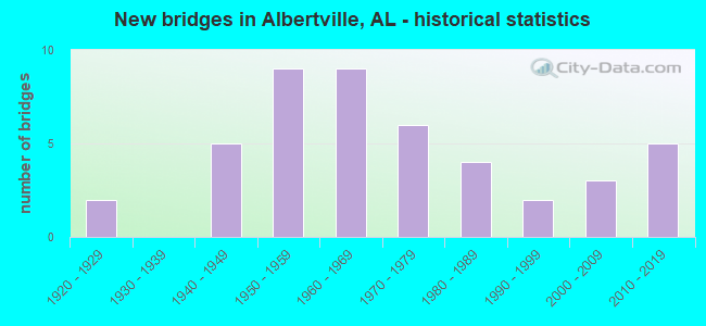
- New bridges - historical statistics
- 21920-1929
- 51940-1949
- 91950-1959
- 91960-1969
- 61970-1979
- 41980-1989
- 21990-1999
- 32000-2009
- 52010-2019
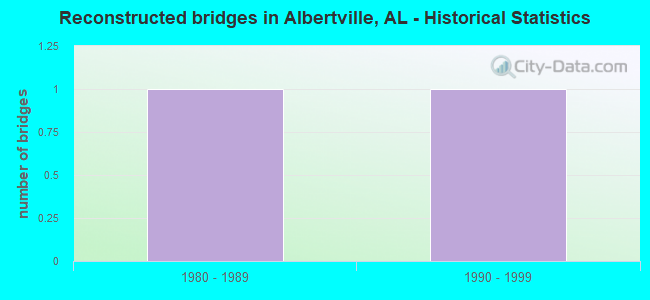
- Reconstructed bridges - Historical Statistics
- 11980-1989
- 11990-1999
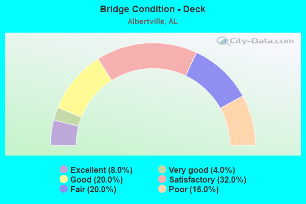
- Bridge Condition - Deck
- 8.0%Excellent
- 4.0%Very good
- 20.0%Good
- 32.0%Satisfactory
- 20.0%Fair
- 16.0%Poor
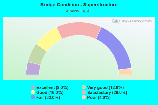
- Bridge Condition - Superstructure
- 8.0%Excellent
- 12.0%Very good
- 16.0%Good
- 28.0%Satisfactory
- 32.0%Fair
- 4.0%Poor
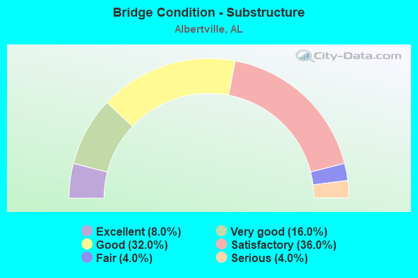
- Bridge Condition - Substructure
- 8.0%Excellent
- 16.0%Very good
- 32.0%Good
- 36.0%Satisfactory
- 4.0%Fair
- 4.0%Serious
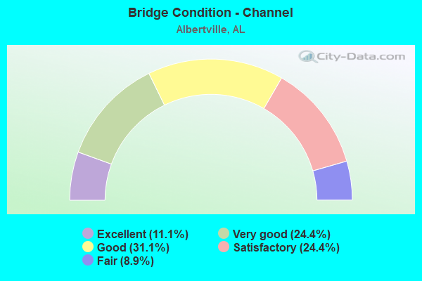
- Bridge Condition - Channel
- 11.1%Excellent
- 24.4%Very good
- 31.1%Good
- 24.4%Satisfactory
- 8.9%Fair
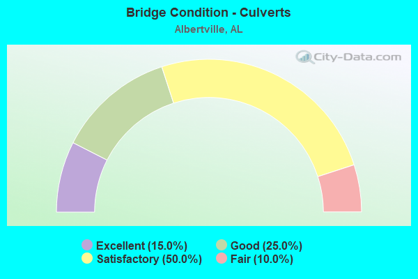
- Bridge Condition - Culverts
- 15.0%Excellent
- 25.0%Good
- 50.0%Satisfactory
- 10.0%Fair
Find on map >> Show street view
Structure Number: 211, Location: 2.8 MI N JCT SR75 * SR205 (Lat: 34.277167, Lng: -86.254511), Route carried "on" structure: State highway 205, Year Built: 1923, Status: Open, Structure Length: 0.67m (2.20ft), Average Daily Traffic: 2,561 (year 2020), Truck Traffic: 2%, Average Future Daily Traffic: 3,585 (year 2040), Design Load: H 15, Features Intersected: BRANCH
Minimum Vertical Clearance: 30+ m (98+ ft), Kilometerpoint: 18.799, Lanes on structure: 2, Owner: State Highway Agency, Approaching Roadway Width: 8.2m (26.9ft), Material/Design: Concrete, Design/Construction: Tee Beam, Number Of Spans In Main Unit: 1, Length of Maximum Span: 6.4m (21.0ft), Curb-To-Curb Width: 6.4m (21.0ft), Out-to-Out Width: 6.6m (21.7ft)
Condition: Deck: Satisfactory, Superstructure: Satisfactory, Substructure: Satisfactory, Channel: Satisfactory, Operating Rating: 59.9 metric tons, Method Used To Determine Operating Rating: Load Factor (LF), Inventory Rating: 35.8 metric tons, Method Used To Determine Inventory Rating: Load Factor (LF), Structural Evaluation: Equal to present minimum criteria, Deck Geometry: High priority of replacement, Waterway Adequacy: Better than present minimum criteria, Approach Roadway Alignment: Somewhat better than minimum adequacy, Length Of Structure Improvement: 1.30m (4.27ft), Designated Inspection Frequency: Every 24 months, Inspection Date: January 2022, Bridge Improvement Cost: $187,000, Roadway Improvement Cost: $19,000, Total Project Cost: $206,000 ( Estimate for 2022), Deck Structure Type: Concrete Cast-file-Place, Wearing Surface/Protective System: Wearing Surface: Bituminous
Find on map >> Show street view
Structure Number: 284, Location: 0 . 3 MI W JCT CO RD 73 (Lat: 33.086839, Lng: -86.873050), Route carried "on" structure: State highway 25, Year Built: 1925, Status: Temporarily open, Structure Length: 1.01m (3.31ft), Average Daily Traffic: 6,830 (year 2021), Truck Traffic: 16%, Average Future Daily Traffic: 9,055 (year 2041), Features Intersected: BRANCH
Minimum Vertical Clearance: 30+ m (98+ ft), Kilometerpoint: 179.305, Lanes on structure: 2, Owner: State Highway Agency, Approaching Roadway Width: 7.3m (24.0ft), Material/Design: Concrete, Design/Construction: Culvert, Number Of Spans In Main Unit: 2, Length of Maximum Span: 3.0m (9.8ft)
Condition: Channel: Fair, Culverts: Fair, Operating Rating: 65.6 metric tons, Method Used To Determine Operating Rating: Load Factor (LF), Inventory Rating: 39.4 metric tons, Method Used To Determine Inventory Rating: Load Factor (LF), Structural Evaluation: Somewhat better than minimum adequacy, Waterway Adequacy: Equal to present minimum criteria, Approach Roadway Alignment: Better than present minimum criteria, Length Of Structure Improvement: 1.68m (5.51ft), Designated Inspection Frequency: Every 24 months, Other Special Inspection Frequency: Every 12 months, Inspection Date: April 2021, Other Special Inspection Date: April 2021, Bridge Improvement Cost: $697,000, Roadway Improvement Cost: $70,000, Total Project Cost: $767,000 ( Estimate for 2022), Wearing Surface/Protective System: Wearing Surface: Bituminous
Find on map >> Show street view
Structure Number: 1831, Location: 4096 FT N JCT 1073 (Lat: 34.252436, Lng: -86.282006), Route carried "on" structure: County highway 152, Year Built: 1966, Status: Open, Structure Length: 0.67m (2.20ft), Average Daily Traffic: 800 (year 1994), Truck Traffic: 1%, Average Future Daily Traffic: 1,200 (year 2040), Design Load: H 10, Features Intersected: BRANCH, Facility Carried by Structure: COUNTY HIGHWAY115
Minimum Vertical Clearance: 30+ m (98+ ft), Kilometerpoint: 0.010, Lanes on structure: 2, Owner: County Highway Agency, Approaching Roadway Width: 9.1m (29.9ft), Material/Design: Concrete, Design/Construction: Culvert, Number Of Spans In Main Unit: 2, Length of Maximum Span: 3.0m (9.8ft)
Condition: Channel: Good, Culverts: Satisfactory, Operating Rating: 44.3 metric tons, Method Used To Determine Operating Rating: Load Factor (LF), Inventory Rating: 26.6 metric tons, Method Used To Determine Inventory Rating: Load Factor (LF), Structural Evaluation: Equal to present minimum criteria, Waterway Adequacy: Better than present minimum criteria, Approach Roadway Alignment: Equal to present desirable criteria, Length Of Structure Improvement: 1.30m (4.27ft), Designated Inspection Frequency: Every 24 months, Inspection Date: September 2020, Bridge Improvement Cost: $240,000, Roadway Improvement Cost: $24,000, Total Project Cost: $264,000 ( Estimate for 2022), Deck Structure Type: Concrete Cast-file-Place, Wearing Surface/Protective System: Wearing Surface: Bituminous
Find on map >> Show street view
Structure Number: 2721, Location: 1.7 MI N JCT US431 * SR75 (Lat: 34.287631, Lng: -86.178197), Route carried "on" structure: State highway 75, Year Built: 1942, Status: Open, Structure Length: 7.35m (24.11ft), Average Daily Traffic: 12,107 (year 2018), Truck Traffic: 11%, Average Future Daily Traffic: 18,070 (year 2038), Design Load: H 15, Features Intersected: TURKEY CREEK
Minimum Vertical Clearance: 30+ m (98+ ft), Kilometerpoint: 97.372, Lanes on structure: 4, Owner: State Highway Agency, Approaching Roadway Width: 14.6m (47.9ft), Skew: 4 degrees, Material/Design: Concrete, Design/Construction: Culvert, Number Of Spans In Main Unit: 3, Length of Maximum Span: 3.0m (9.8ft)
Condition: Channel: Satisfactory, Culverts: Satisfactory, Operating Rating: 88.9 metric tons, Method Used To Determine Operating Rating: Load Factor (LF), Inventory Rating: 88.9 metric tons, Method Used To Determine Inventory Rating: Load Factor (LF), Structural Evaluation: Equal to present minimum criteria, Waterway Adequacy: Equal to present minimum criteria, Approach Roadway Alignment: Equal to present desirable criteria, Length Of Structure Improvement: 8.37m (27.46ft), Designated Inspection Frequency: Every 24 months, Inspection Date: August 2020, Bridge Improvement Cost: $10,150,000, Roadway Improvement Cost: $1,015,000, Total Project Cost: $11,165,000 ( Estimate for 2022)
Find on map >> Show street view
Structure Number: 2722, Location: 1.1 MI S JCT SR68 * SR75 (Lat: 34.293511, Lng: -86.163481), Route carried "on" structure: State highway 75, Year Built: 1942, Status: Open, Structure Length: 6.58m (21.59ft), Average Daily Traffic: 10,717 (year 2020), Truck Traffic: 12%, Average Future Daily Traffic: 15,004 (year 2040), Design Load: H 15, Features Intersected: SHORT CREEK
Minimum Vertical Clearance: 30+ m (98+ ft), Kilometerpoint: 98.839, Lanes on structure: 2, Owner: State Highway Agency, Approaching Roadway Width: 11.0m (36.1ft), Skew: 3 degrees, Material/Design: Concrete, Design/Construction: Tee Beam, Number Of Spans In Main Unit: 6, Length of Maximum Span: 11.0m (36.1ft), Curb or Sidewalk Widths: Left: 0.5m (1.6ft), Right: 0.5m (1.6ft), Curb-To-Curb Width: 7.3m (24.0ft), Out-to-Out Width: 9.0m (29.5ft)
Condition: Deck: Satisfactory, Superstructure: Satisfactory, Substructure: Satisfactory, Channel: Fair, Operating Rating: 37.9 metric tons, Method Used To Determine Operating Rating: Load Factor (LF), Inventory Rating: 22.8 metric tons, Method Used To Determine Inventory Rating: Load Factor (LF), Structural Evaluation: Somewhat better than minimum adequacy, Deck Geometry: High priority of replacement, Waterway Adequacy: Equal to present minimum criteria, Approach Roadway Alignment: Equal to present desirable criteria, Length Of Structure Improvement: 7.62m (25.00ft), Designated Inspection Frequency: Every 24 months, Inspection Date: September 2021, Bridge Improvement Cost: $1,515,000, Roadway Improvement Cost: $152,000, Total Project Cost: $1,667,000 ( Estimate for 2022), Deck Structure Type: Concrete Cast-file-Place, Wearing Surface/Protective System: Wearing Surface: Bituminous
Find on map >> Show street view
Structure Number: 284, Location: East Main Street (Lat: 34.266667, Lng: -86.190000), Route carried "on" structure: City street , Year Built: 1945, Status: Open, Structure Length: 0.76m (2.49ft), Average Daily Traffic: 2,200 (year 2021), Truck Traffic: 1%, Average Future Daily Traffic: 2,400 (year 2041), Design Load: H 10, Features Intersected: TURKEY CREEK, Facility Carried by Structure: EAST MAIN ST
Minimum Vertical Clearance: 30+ m (98+ ft), Kilometerpoint: 0.010, Lanes on structure: 2, Owner: City or Municipal Highway Agency, Approaching Roadway Width: 9.4m (30.8ft), Material/Design: Concrete, Design/Construction: Culvert, Number Of Spans In Main Unit: 2, Length of Maximum Span: 3.7m (12.1ft)
Condition: Channel: Satisfactory, Culverts: Good, Operating Rating: 53.3 metric tons, Method Used To Determine Operating Rating: Load Factor (LF), Inventory Rating: 32.0 metric tons, Method Used To Determine Inventory Rating: Load Factor (LF), Structural Evaluation: Better than present minimum criteria, Waterway Adequacy: Equal to present minimum criteria, Approach Roadway Alignment: Equal to present minimum criteria, Length Of Structure Improvement: 1.41m (4.63ft), Designated Inspection Frequency: Every 24 months, Inspection Date: May 2021, Bridge Improvement Cost: $325,000, Roadway Improvement Cost: $33,000, Total Project Cost: $358,000 ( Estimate for 2022), Wearing Surface/Protective System: Wearing Surface: Bituminous
Find on map >> Show street view
Structure Number: 3106, Location: 3.7 MI N JCT SR168 * SR75 (Lat: 34.213044, Lng: -86.279647), Route carried "on" structure: State highway 75, Year Built: 1947, Status: Open, Structure Length: 5.18m (16.99ft), Average Daily Traffic: 6,361 (year 2019), Truck Traffic: 6%, Average Future Daily Traffic: 8,905 (year 2039), Design Load: H 15, Features Intersected: SLAB CREEK
Minimum Vertical Clearance: 30+ m (98+ ft), Kilometerpoint: 84.582, Lanes on structure: 2, Owner: State Highway Agency, Approaching Roadway Width: 10.4m (34.1ft), Material/Design: Concrete, Design/Construction: Tee Beam, Number Of Spans In Main Unit: 5, Length of Maximum Span: 10.4m (34.1ft), Curb or Sidewalk Widths: Left: 0.5m (1.6ft), Right: 0.5m (1.6ft), Curb-To-Curb Width: 7.3m (24.0ft), Out-to-Out Width: 9.0m (29.5ft)
Condition: Deck: Fair, Superstructure: Satisfactory, Substructure: Satisfactory, Channel: Satisfactory, Operating Rating: 41.6 metric tons, Method Used To Determine Operating Rating: Load Factor (LF), Inventory Rating: 24.9 metric tons, Method Used To Determine Inventory Rating: Load Factor (LF), Structural Evaluation: Equal to present minimum criteria, Deck Geometry: High priority of replacement, Waterway Adequacy: Equal to present minimum criteria, Approach Roadway Alignment: Equal to present desirable criteria, Length Of Structure Improvement: 6.20m (20.34ft), Designated Inspection Frequency: Every 24 months, Inspection Date: December 2020, Bridge Improvement Cost: $1,233,000, Roadway Improvement Cost: $123,000, Total Project Cost: $1,356,000 ( Estimate for 2022), Deck Structure Type: Concrete Cast-file-Place, Wearing Surface/Protective System: Wearing Surface: Bituminous
Find on map >> Show street view
Structure Number: 4135, Location: Whitesville Road (Lat: 34.243333, Lng: -86.223333), Route carried "on" structure: City street , Year Built: 1951, Status: Open, Structure Length: 0.64m (2.10ft), Average Daily Traffic: 140 (year 2021), Truck Traffic: 1%, Average Future Daily Traffic: 140 (year 2041), Design Load: H 10, Features Intersected: CREEK, Facility Carried by Structure: WHITESVILLE RD
Minimum Vertical Clearance: 30+ m (98+ ft), Kilometerpoint: 0.010, Lanes on structure: 2, Owner: City or Municipal Highway Agency, Approaching Roadway Width: 9.1m (29.9ft), Material/Design: Concrete, Design/Construction: Culvert, Number Of Spans In Main Unit: 2, Length of Maximum Span: 3.0m (9.8ft)
Condition: Channel: Satisfactory, Culverts: Good, Operating Rating: 88.9 metric tons, Method Used To Determine Operating Rating: Load Factor (LF), Inventory Rating: 88.9 metric tons, Method Used To Determine Inventory Rating: Load Factor (LF), Structural Evaluation: Better than present minimum criteria, Waterway Adequacy: Better than present minimum criteria, Approach Roadway Alignment: Better than present minimum criteria, Length Of Structure Improvement: 1.26m (4.13ft), Designated Inspection Frequency: Every 24 months, Inspection Date: May 2021, Bridge Improvement Cost: $218,000, Roadway Improvement Cost: $22,000, Total Project Cost: $240,000 ( Estimate for 2022), Wearing Surface/Protective System: Wearing Surface: Bituminous
Find on map >> Show street view
Structure Number: 4139, Location: 7087 FT NW JCT 1127 (Lat: 34.212236, Lng: -86.272875), Route carried "on" structure: County highway 128, Year Built: 1951, Status: Posted for load, Structure Length: 1.55m (5.09ft), Average Daily Traffic: 100 (year 1994), Average Future Daily Traffic: 200 (year 2041), Design Load: H 10, Features Intersected: BIG SLAB CREEK
Minimum Vertical Clearance: 30+ m (98+ ft), Kilometerpoint: 0.010, Lanes on structure: 2, Owner: County Highway Agency, Approaching Roadway Width: 7.9m (25.9ft), Material/Design: Steel, Design/Construction: Stringer/Multi-beam, Number Of Spans In Main Unit: 1, Length of Maximum Span: 14.3m (46.9ft), Curb-To-Curb Width: 6.1m (20.0ft), Out-to-Out Width: 6.6m (21.7ft)
Condition: Deck: Satisfactory, Superstructure: Satisfactory, Substructure: Satisfactory, Channel: Good, Operating Rating: 20.7 metric tons, Method Used To Determine Operating Rating: Allowable Stress (AS), Inventory Rating: 11.1 metric tons, Method Used To Determine Inventory Rating: Allowable Stress (AS), Structural Evaluation: Meets minimum limits, Deck Geometry: Somewhat better than minimum adequacy, Waterway Adequacy: Meets minimum limits, Approach Roadway Alignment: Meets minimum limits, Bridge Posting: Required (Relationship of Operating Rating to Maximum Legal Load: > 39.9% below), Length Of Structure Improvement: 2.23m (7.32ft), Designated Inspection Frequency: Every 24 months, Other Special Inspection Frequency: Every 12 months, Inspection Date: August 2020, Other Special Inspection Date: August 2021, Bridge Improvement Cost: $322,000, Roadway Improvement Cost: $32,000, Total Project Cost: $354,000 ( Estimate for 2022), Deck Structure Type: Concrete Cast-file-Place
Find on map >> Show street view
Structure Number: 4141, Location: 5996 FT S JCT 1073 (Lat: 34.222181, Lng: -86.289028), Route carried "on" structure: County highway 131, Year Built: 1958, Status: Posted for load, Structure Length: 2.47m (8.10ft), Average Daily Traffic: 850 (year 1994), Truck Traffic: 1%, Average Future Daily Traffic: 1,200 (year 2040), Design Load: H 10, Features Intersected: SLAB CREEK
Minimum Vertical Clearance: 30+ m (98+ ft), Kilometerpoint: 0.010, Lanes on structure: 2, Owner: County Highway Agency, Approaching Roadway Width: 9.1m (29.9ft), Material/Design: Steel, Design/Construction: Stringer/Multi-beam, Number Of Spans In Main Unit: 2, Length of Maximum Span: 11.9m (39.0ft), Curb-To-Curb Width: 6.2m (20.3ft), Out-to-Out Width: 6.7m (22.0ft)
Condition: Deck: Poor, Superstructure: Fair, Substructure: Good, Channel: Very good, Operating Rating: 16.5 metric tons, Method Used To Determine Operating Rating: Allowable Stress (AS), Inventory Rating: 10.2 metric tons, Method Used To Determine Inventory Rating: Allowable Stress (AS), Structural Evaluation: High priority of replacement, Deck Geometry: High priority of corrective action, Waterway Adequacy: Superior to present desirable criteria, Approach Roadway Alignment: Somewhat better than minimum adequacy, Bridge Posting: Required (Relationship of Operating Rating to Maximum Legal Load: > 39.9% below), Length Of Structure Improvement: 3.34m (10.96ft), Designated Inspection Frequency: Every 24 months, Other Special Inspection Frequency: Every 12 months, Inspection Date: September 2020, Other Special Inspection Date: September 2021, Bridge Improvement Cost: $504,000, Roadway Improvement Cost: $50,000, Total Project Cost: $554,000 ( Estimate for 2022), Deck Structure Type: Concrete Cast-file-Place
Find on map >> Show street view
Structure Number: 4149, Location: 6354 FT S JCT 1073 (Lat: 34.225744, Lng: -86.272111), Route carried "on" structure: County highway 152, Year Built: 1960, Status: Open, Structure Length: 0.67m (2.20ft), Average Daily Traffic: 800 (year 1994), Truck Traffic: 1%, Average Future Daily Traffic: 1,200 (year 2040), Design Load: H 10, Features Intersected: SLAB CREEK, Facility Carried by Structure: COUNTY HIGHWAY115
Minimum Vertical Clearance: 30+ m (98+ ft), Kilometerpoint: 0.010, Lanes on structure: 2, Owner: County Highway Agency, Approaching Roadway Width: 9.1m (29.9ft), Material/Design: Concrete, Design/Construction: Culvert, Number Of Spans In Main Unit: 2, Length of Maximum Span: 3.0m (9.8ft)
Condition: Channel: Very good, Culverts: Satisfactory, Operating Rating: 38.6 metric tons, Method Used To Determine Operating Rating: Load Factor (LF), Inventory Rating: 23.1 metric tons, Method Used To Determine Inventory Rating: Load Factor (LF), Structural Evaluation: Equal to present minimum criteria, Waterway Adequacy: Superior to present desirable criteria, Approach Roadway Alignment: Better than present minimum criteria, Length Of Structure Improvement: 1.30m (4.27ft), Designated Inspection Frequency: Every 24 months, Inspection Date: September 2020, Bridge Improvement Cost: $345,000, Roadway Improvement Cost: $35,000, Total Project Cost: $380,000 ( Estimate for 2022), Wearing Surface/Protective System: Wearing Surface: Bituminous
Find on map >> Show street view
Structure Number: 4153, Location: 2058 FT SW JCT 1159 (Lat: 34.244764, Lng: -86.318442), Route carried "on" structure: County highway 161, Year Built: 1951, Status: Open, Structure Length: 1.01m (3.31ft), Average Daily Traffic: 500 (year 1994), Truck Traffic: 1%, Average Future Daily Traffic: 1,000 (year 2040), Design Load: H 10, Features Intersected: CREEK, Facility Carried by Structure: COUNTY HIGHWAY116
Minimum Vertical Clearance: 30+ m (98+ ft), Kilometerpoint: 0.010, Lanes on structure: 2, Owner: County Highway Agency, Approaching Roadway Width: 9.1m (29.9ft), Material/Design: Concrete, Design/Construction: Culvert, Number Of Spans In Main Unit: 3, Length of Maximum Span: 3.0m (9.8ft)
Condition: Channel: Good, Culverts: Satisfactory, Operating Rating: 51.4 metric tons, Method Used To Determine Operating Rating: Load Factor (LF), Inventory Rating: 30.8 metric tons, Method Used To Determine Inventory Rating: Load Factor (LF), Structural Evaluation: Equal to present minimum criteria, Waterway Adequacy: Better than present minimum criteria, Approach Roadway Alignment: Better than present minimum criteria, Length Of Structure Improvement: 1.68m (5.51ft), Designated Inspection Frequency: Every 24 months, Inspection Date: October 2020, Bridge Improvement Cost: $330,000, Roadway Improvement Cost: $33,000, Total Project Cost: $363,000 ( Estimate for 2022), Wearing Surface/Protective System: Wearing Surface: Gravel
Find on map >> Show street view
Structure Number: 4185, Location: 639 FT N JCT 1312 (Lat: 34.300000, Lng: -86.211811), Route carried "on" structure: County highway 415, Year Built: 1951, Status: Posted for load, Structure Length: 0.76m (2.49ft), Average Daily Traffic: 280 (year 2000), Truck Traffic: 1%, Average Future Daily Traffic: 350 (year 2040), Design Load: H 10, Features Intersected: BERRY BRANCH
Minimum Vertical Clearance: 30+ m (98+ ft), Kilometerpoint: 0.010, Lanes on structure: 2, Owner: County Highway Agency, Approaching Roadway Width: 7.9m (25.9ft), Material/Design: Steel, Design/Construction: Stringer/Multi-beam, Number Of Spans In Main Unit: 1, Length of Maximum Span: 7.0m (23.0ft), Curb-To-Curb Width: 6.2m (20.3ft), Out-to-Out Width: 6.6m (21.7ft)
Condition: Deck: Fair, Superstructure: Poor, Substructure: Satisfactory, Channel: Good, Operating Rating: 5.4 metric tons, Method Used To Determine Operating Rating: Allowable Stress (AS), Inventory Rating: 3.6 metric tons, Method Used To Determine Inventory Rating: Allowable Stress (AS), Structural Evaluation: High priority of replacement, Deck Geometry: Meets minimum limits, Waterway Adequacy: Meets minimum limits, Approach Roadway Alignment: Better than present minimum criteria, Bridge Posting: Required (Relationship of Operating Rating to Maximum Legal Load: > 39.9% below), Length Of Structure Improvement: 1.41m (4.63ft), Designated Inspection Frequency: Every 24 months, Other Special Inspection Frequency: Every 12 months, Inspection Date: December 2020, Other Special Inspection Date: December 2021, Bridge Improvement Cost: $203,000, Roadway Improvement Cost: $20,000, Total Project Cost: $223,000 ( Estimate for 2022), Deck Structure Type: Concrete Cast-file-Place, Wearing Surface/Protective System: Wearing Surface: Gravel
Find on map >> Show street view
Structure Number: 4186, Location: 1095 FT S JCT 1312 (Lat: 34.311236, Lng: -86.211517), Route carried "on" structure: County highway 415, Year Built: 1951, Status: Posted for load, Structure Length: 2.47m (8.10ft), Average Daily Traffic: 280 (year 2000), Truck Traffic: 1%, Average Future Daily Traffic: 350 (year 2040), Design Load: H 10, Features Intersected: DRUM CREEK
Minimum Vertical Clearance: 30+ m (98+ ft), Kilometerpoint: 0.010, Lanes on structure: 2, Owner: County Highway Agency, Approaching Roadway Width: 7.9m (25.9ft), Material/Design: Steel, Design/Construction: Stringer/Multi-beam, Number Of Spans In Main Unit: 1, Length of Maximum Span: 24.1m (79.1ft), Curb-To-Curb Width: 6.1m (20.0ft), Out-to-Out Width: 6.8m (22.3ft)
Condition: Deck: Fair, Superstructure: Fair, Substructure: Fair, Channel: Excellent, Operating Rating: 22.9 metric tons, Method Used To Determine Operating Rating: Allowable Stress (AS), Inventory Rating: 10.2 metric tons, Method Used To Determine Inventory Rating: Allowable Stress (AS), Structural Evaluation: High priority of replacement, Deck Geometry: Meets minimum limits, Waterway Adequacy: Superior to present desirable criteria, Approach Roadway Alignment: Equal to present minimum criteria, Bridge Posting: Required (Relationship of Operating Rating to Maximum Legal Load: 30.0 - 39.9% below), Length Of Structure Improvement: 3.34m (10.96ft), Designated Inspection Frequency: Every 24 months, Other Special Inspection Frequency: Every 12 months, Inspection Date: December 2020, Other Special Inspection Date: December 2021, Bridge Improvement Cost: $504,000, Roadway Improvement Cost: $50,000, Total Project Cost: $554,000 ( Estimate for 2022), Deck Structure Type: Concrete Cast-file-Place
Find on map >> Show street view
Structure Number: 4265, Location: 1.5 MI S JCT US431 * SR75 (Lat: 34.262111, Lng: -86.188944), Route carried "on" structure: US 431, Year Built: 1952, Status: Open, Structure Length: 0.73m (2.40ft), Average Daily Traffic: 31,717 (year 2019), Truck Traffic: 7%, Average Future Daily Traffic: 44,488 (year 2039), Design Load: H 15, Features Intersected: TURKEY CREEK
Minimum Vertical Clearance: 30+ m (98+ ft), Kilometerpoint: 459.448, Lanes on structure: 6, Base Highway Network: Yes, Owner: State Highway Agency, Approaching Roadway Width: 20.7m (67.9ft), Skew: 13 degrees, Material/Design: Concrete, Design/Construction: Culvert, Number Of Spans In Main Unit: 2, Length of Maximum Span: 3.0m (9.8ft)
Condition: Channel: Satisfactory, Culverts: Satisfactory, Operating Rating: 88.9 metric tons, Method Used To Determine Operating Rating: Load Factor (LF), Inventory Rating: 88.9 metric tons, Method Used To Determine Inventory Rating: Load Factor (LF), Structural Evaluation: Equal to present minimum criteria, Waterway Adequacy: Equal to present minimum criteria, Approach Roadway Alignment: Equal to present desirable criteria, Length Of Structure Improvement: 1.38m (4.53ft), Designated Inspection Frequency: Every 24 months, Inspection Date: October 2020, Bridge Improvement Cost: $1,113,000, Roadway Improvement Cost: $111,000, Total Project Cost: $1,224,000 ( Estimate for 2022), Wearing Surface/Protective System: Wearing Surface: Bituminous
Find on map >> Show street view
Structure Number: 4266, Location: 2.4 MI N JCT US431 * SR75 (Lat: 34.290000, Lng: -86.243333), Route carried "on" structure: US 431, Year Built: 1952, Status: Open, Structure Length: 1.28m (4.20ft), Average Daily Traffic: 30,733 (year 2019), Truck Traffic: 7%, Average Future Daily Traffic: 43,026 (year 2039), Design Load: H 15, Features Intersected: DRUM CREEK
Minimum Vertical Clearance: 30+ m (98+ ft), Kilometerpoint: 465.388, Lanes on structure: 4, Base Highway Network: Yes, Owner: State Highway Agency, Approaching Roadway Width: 14.2m (46.6ft), Skew: 20 degrees, Material/Design: Concrete, Design/Construction: Culvert, Number Of Spans In Main Unit: 4, Length of Maximum Span: 3.0m (9.8ft)
Condition: Channel: Satisfactory, Culverts: Fair, Operating Rating: 64.5 metric tons, Method Used To Determine Operating Rating: Load Factor (LF), Inventory Rating: 38.6 metric tons, Method Used To Determine Inventory Rating: Load Factor (LF), Structural Evaluation: Somewhat better than minimum adequacy, Waterway Adequacy: Equal to present minimum criteria, Approach Roadway Alignment: Equal to present desirable criteria, Length Of Structure Improvement: 1.95m (6.40ft), Designated Inspection Frequency: Every 24 months, Inspection Date: October 2020, Bridge Improvement Cost: $1,286,000, Roadway Improvement Cost: $129,000, Total Project Cost: $1,415,000 ( Estimate for 2022), Wearing Surface/Protective System: Wearing Surface: Bituminous
Find on map >> Show street view
Structure Number: 7141, Location: 916 FT E JCT 1132 (Lat: 34.210342, Lng: -86.264544), Route carried "on" structure: County highway 133, Year Built: 1960, Status: Posted for load, Structure Length: 1.55m (5.09ft), Average Daily Traffic: 100 (year 1994), Average Future Daily Traffic: 300 (year 2040), Design Load: H 10, Features Intersected: LITTLE SLAB CREEK
Minimum Vertical Clearance: 30+ m (98+ ft), Kilometerpoint: 0.010, Lanes on structure: 2, Owner: County Highway Agency, Approaching Roadway Width: 7.9m (25.9ft), Material/Design: Steel, Design/Construction: Stringer/Multi-beam, Number Of Spans In Main Unit: 1, Length of Maximum Span: 14.3m (46.9ft), Curb-To-Curb Width: 6.1m (20.0ft), Out-to-Out Width: 6.6m (21.7ft)
Condition: Deck: Satisfactory, Superstructure: Good, Substructure: Satisfactory, Channel: Good, Operating Rating: 17.7 metric tons, Method Used To Determine Operating Rating: Allowable Stress (AS), Inventory Rating: 9.3 metric tons, Method Used To Determine Inventory Rating: Allowable Stress (AS), Structural Evaluation: High priority of replacement, Deck Geometry: Somewhat better than minimum adequacy, Waterway Adequacy: Better than present minimum criteria, Approach Roadway Alignment: Equal to present minimum criteria, Bridge Posting: Required (Relationship of Operating Rating to Maximum Legal Load: > 39.9% below), Length Of Structure Improvement: 2.23m (7.32ft), Designated Inspection Frequency: Every 24 months, Other Special Inspection Frequency: Every 12 months, Inspection Date: August 2020, Other Special Inspection Date: August 2021, Bridge Improvement Cost: $322,000, Roadway Improvement Cost: $32,000, Total Project Cost: $354,000 ( Estimate for 2022), Deck Structure Type: Concrete Cast-file-Place
Find on map >> Show street view
Structure Number: 7175, Location: 3332 FT NE JCT 1352 (Lat: 34.210017, Lng: -86.203536), Route carried "on" structure: County highway 344, Year Built: 1960, Status: Open, Structure Length: 1.37m (4.49ft), Average Daily Traffic: 399 (year 1994), Truck Traffic: 1%, Average Future Daily Traffic: 650 (year 2040), Design Load: H 10, Features Intersected: BIG SLAB CREEK, Facility Carried by Structure: COUNTY HIGHWAY134
Minimum Vertical Clearance: 30+ m (98+ ft), Kilometerpoint: 0.010, Lanes on structure: 2, Owner: County Highway Agency, Approaching Roadway Width: 7.9m (25.9ft), Skew: 3 degrees, Material/Design: Concrete, Design/Construction: Culvert, Number Of Spans In Main Unit: 3, Length of Maximum Span: 4.9m (16.1ft)
Condition: Channel: Very good, Culverts: Good, Operating Rating: 46.8 metric tons, Method Used To Determine Operating Rating: Load Factor (LF), Inventory Rating: 28.1 metric tons, Method Used To Determine Inventory Rating: Load Factor (LF), Structural Evaluation: Better than present minimum criteria, Waterway Adequacy: Equal to present desirable criteria, Approach Roadway Alignment: Equal to present minimum criteria, Length Of Structure Improvement: 2.04m (6.69ft), Designated Inspection Frequency: Every 24 months, Inspection Date: October 2020, Bridge Improvement Cost: $531,000, Roadway Improvement Cost: $53,000, Total Project Cost: $584,000 ( Estimate for 2022), Wearing Surface/Protective System: Wearing Surface: Bituminous
Find on map >> Show street view
Structure Number: 7176, Location: 7322 FT S JCT 1561 (Lat: 34.314631, Lng: -86.112342), Route carried "on" structure: County highway 372, Year Built: 1960, Status: Open, Structure Length: 1.34m (4.40ft), Average Daily Traffic: 200 (year 2000), Truck Traffic: 1%, Average Future Daily Traffic: 300 (year 2040), Design Load: H 10, Features Intersected: WHIPPORWILL CREEK, Facility Carried by Structure: COUNTY HIGHWAY137
Minimum Vertical Clearance: 30+ m (98+ ft), Kilometerpoint: 0.010, Lanes on structure: 2, Owner: County Highway Agency, Approaching Roadway Width: 7.9m (25.9ft), Skew: 3 degrees, Material/Design: Concrete, Design/Construction: Culvert, Number Of Spans In Main Unit: 3, Length of Maximum Span: 3.7m (12.1ft)
Condition: Channel: Good, Culverts: Satisfactory, Operating Rating: 67.2 metric tons, Method Used To Determine Operating Rating: Load Factor (LF), Inventory Rating: 40.3 metric tons, Method Used To Determine Inventory Rating: Load Factor (LF), Structural Evaluation: Equal to present minimum criteria, Waterway Adequacy: Equal to present desirable criteria, Approach Roadway Alignment: Better than present minimum criteria, Length Of Structure Improvement: 2.02m (6.63ft), Designated Inspection Frequency: Every 24 months, Inspection Date: November 2020, Bridge Improvement Cost: $489,000, Roadway Improvement Cost: $49,000, Total Project Cost: $538,000 ( Estimate for 2022), Wearing Surface/Protective System: Wearing Surface: Bituminous
Find on map >> Show street view
Structure Number: 7177, Location: 7118 FT S JCT 68 (Lat: 34.269311, Lng: -86.136878), Route carried "on" structure: County highway 372, Year Built: 1957, Status: Posted for load, Structure Length: 8.23m (27.00ft), Average Daily Traffic: 2,150 (year 2000), Truck Traffic: 10%, Average Future Daily Traffic: 3,200 (year 2038), Design Load: H 15, Features Intersected: SHORT CREEK
Minimum Vertical Clearance: 7.56m (24.80ft), Kilometerpoint: 0.010, Lanes on structure: 2, Owner: County Highway Agency, Approaching Roadway Width: 9.1m (29.9ft), Material/Design: Steel, Design/Construction: Stringer/Multi-beam, Number Of Spans In Main Unit: 1, Number Of Approach Spans: 5, Length of Maximum Span: 24.4m (80.1ft), Curb-To-Curb Width: 6.7m (22.0ft), Out-to-Out Width: 7.7m (25.3ft)
Condition: Deck: Satisfactory, Superstructure: Satisfactory, Substructure: Good, Channel: Good, Operating Rating: 38.0 metric tons, Method Used To Determine Operating Rating: Load Factor (LF), Inventory Rating: 22.7 metric tons, Method Used To Determine Inventory Rating: Load Factor (LF), Structural Evaluation: Equal to present minimum criteria, Deck Geometry: High priority of replacement, Waterway Adequacy: Superior to present desirable criteria, Approach Roadway Alignment: High priority of corrective action, Bridge Posting: Required (Relationship of Operating Rating to Maximum Legal Load: 20.0 - 29.9% below), Length Of Structure Improvement: 9.23m (30.28ft), Designated Inspection Frequency: Every 24 months, Other Special Inspection Frequency: Every 12 months, Inspection Date: July 2020, Other Special Inspection Date: July 2021, Bridge Improvement Cost: $1,582,000, Roadway Improvement Cost: $158,000, Total Project Cost: $1,740,000 ( Estimate for 2022), Deck Structure Type: Concrete Cast-file-Place
Find on map >> Show street view
Structure Number: 7181, Location: 2406 FT N JCT 1321 (Lat: 34.301044, Lng: -86.218469), Route carried "on" structure: County highway 422, Year Built: 1960, Status: Posted for load, Structure Length: 1.10m (3.61ft), Average Daily Traffic: 172 (year 2000), Truck Traffic: 1%, Average Future Daily Traffic: 250 (year 2040), Design Load: H 10, Features Intersected: DRUM CREEK
Minimum Vertical Clearance: 30+ m (98+ ft), Kilometerpoint: 0.010, Lanes on structure: 2, Owner: County Highway Agency, Approaching Roadway Width: 7.9m (25.9ft), Material/Design: Steel, Design/Construction: Stringer/Multi-beam, Number Of Spans In Main Unit: 1, Length of Maximum Span: 10.4m (34.1ft), Curb-To-Curb Width: 6.1m (20.0ft), Out-to-Out Width: 6.6m (21.7ft)
Condition: Deck: Fair, Superstructure: Fair, Substructure: Satisfactory, Channel: Good, Operating Rating: 6.4 metric tons, Method Used To Determine Operating Rating: Allowable Stress (AS), Inventory Rating: 1.8 metric tons, Method Used To Determine Inventory Rating: Allowable Stress (AS), Structural Evaluation: High priority of replacement, Deck Geometry: Meets minimum limits, Waterway Adequacy: Meets minimum limits, Approach Roadway Alignment: Better than present minimum criteria, Bridge Posting: Required (Relationship of Operating Rating to Maximum Legal Load: > 39.9% below), Length Of Structure Improvement: 1.77m (5.81ft), Designated Inspection Frequency: Every 24 months, Other Special Inspection Frequency: Every 12 months, Inspection Date: December 2020, Other Special Inspection Date: December 2021, Bridge Improvement Cost: $256,000, Roadway Improvement Cost: $26,000, Total Project Cost: $282,000 ( Estimate for 2022), Deck Structure Type: Concrete Cast-file-Place
Find on map >> Show street view
Structure Number: 7783, Location: Turnpike Road (Lat: 34.238333, Lng: -86.238333), Route carried "on" structure: City street , Year Built: 1962, Status: Open, Structure Length: 0.64m (2.10ft), Average Daily Traffic: 150 (year 2021), Truck Traffic: 1%, Average Future Daily Traffic: 160 (year 2041), Design Load: H 15, Features Intersected: CREEK, Facility Carried by Structure: TURNPIKE RD
Minimum Vertical Clearance: 30+ m (98+ ft), Kilometerpoint: 0.010, Lanes on structure: 2, Owner: City or Municipal Highway Agency, Approaching Roadway Width: 9.8m (32.2ft), Material/Design: Concrete, Design/Construction: Culvert, Number Of Spans In Main Unit: 2, Length of Maximum Span: 3.0m (9.8ft)
Condition: Channel: Satisfactory, Culverts: Good, Operating Rating: 88.6 metric tons, Method Used To Determine Operating Rating: Load Factor (LF), Inventory Rating: 53.2 metric tons, Method Used To Determine Inventory Rating: Load Factor (LF), Structural Evaluation: Better than present minimum criteria, Waterway Adequacy: Better than present minimum criteria, Approach Roadway Alignment: Equal to present minimum criteria, Length Of Structure Improvement: 1.26m (4.13ft), Designated Inspection Frequency: Every 24 months, Inspection Date: May 2021, Bridge Improvement Cost: $306,000, Roadway Improvement Cost: $31,000, Total Project Cost: $337,000 ( Estimate for 2022), Wearing Surface/Protective System: Wearing Surface: Bituminous
Find on map >> Show street view
Structure Number: 7821, Location: 11916 FT NW JCT 1409 (Lat: 34.320461, Lng: -86.204781), Route carried "on" structure: County highway 414, Year Built: 1962, Status: Posted for load, Structure Length: 14.30m (46.92ft), Average Daily Traffic: 2,500 (year 2000), Truck Traffic: 90%, Average Future Daily Traffic: 3,000 (year 2040), Design Load: H 15, Features Intersected: SHORT CREEK
Minimum Vertical Clearance: 30+ m (98+ ft), Kilometerpoint: 0.010, Lanes on structure: 2, Owner: County Highway Agency, Approaching Roadway Width: 9.1m (29.9ft), Material/Design: Steel, Design/Construction: Stringer/Multi-beam, Number Of Spans In Main Unit: 4, Number Of Approach Spans: 3, Length of Maximum Span: 30.5m (100.1ft), Curb-To-Curb Width: 7.2m (23.6ft), Out-to-Out Width: 8.8m (28.9ft)
Condition: Deck: Satisfactory, Superstructure: Fair, Substructure: Good, Channel: Very good, Operating Rating: 34.2 metric tons, Method Used To Determine Operating Rating: Load Factor (LF), Inventory Rating: 20.7 metric tons, Method Used To Determine Inventory Rating: Load Factor (LF), Structural Evaluation: Somewhat better than minimum adequacy, Deck Geometry: High priority of replacement, Waterway Adequacy: Superior to present desirable criteria, Approach Roadway Alignment: Equal to present minimum criteria, Bridge Posting: Required (Relationship of Operating Rating to Maximum Legal Load: > 39.9% below), Length Of Structure Improvement: 15.09m (49.51ft), Designated Inspection Frequency: Every 24 months, Other Special Inspection Frequency: Every 12 months, Inspection Date: July 2020, Other Special Inspection Date: July 2021, Bridge Improvement Cost: $2,897,000, Roadway Improvement Cost: $290,000, Total Project Cost: $3,187,000 ( Estimate for 2022), Deck Structure Type: Concrete Cast-file-Place
Find on map >> Show street view
Structure Number: 1075, Location: Corbinville Road (Lat: 34.277319, Lng: -86.187811), Route carried "on" structure: City street , Year Built: 1972, Year Reconstructed: 2002, Status: Open, Structure Length: 0.76m (2.49ft), Average Daily Traffic: 625 (year 2021), Truck Traffic: 1%, Average Future Daily Traffic: 750 (year 2041), Design Load: H 15, Features Intersected: TURKEY CREEK, Facility Carried by Structure: CORBINVILLE RD
Minimum Vertical Clearance: 30+ m (98+ ft), Kilometerpoint: 0.010, Lanes on structure: 2, Owner: City or Municipal Highway Agency, Approaching Roadway Width: 7.6m (24.9ft), Material/Design: Steel, Design/Construction: Culvert, Number Of Spans In Main Unit: 2, Length of Maximum Span: 2.4m (7.9ft)
Condition: Channel: Satisfactory, Culverts: Satisfactory, Operating Rating: 83.6 metric tons, Method Used To Determine Operating Rating: Load Factor (LF), Inventory Rating: 83.6 metric tons, Method Used To Determine Inventory Rating: Load Factor (LF), Structural Evaluation: Equal to present minimum criteria, Waterway Adequacy: Equal to present minimum criteria, Approach Roadway Alignment: Equal to present minimum criteria, Length Of Structure Improvement: 1.40m (4.59ft), Designated Inspection Frequency: Every 24 months, Inspection Date: May 2021, Bridge Improvement Cost: $348,000, Roadway Improvement Cost: $35,000, Total Project Cost: $383,000 ( Estimate for 2022), Wearing Surface/Protective System: Wearing Surface: Bituminous
Find on map >> Show street view
Structure Number: 11249, Location: Cochran Avenue (Lat: 34.283397, Lng: -86.179475), Route carried "on" structure: City street , Year Built: 1974, Status: Posted for load, Structure Length: 0.85m (2.79ft), Average Daily Traffic: 700 (year 2021), Truck Traffic: 1%, Average Future Daily Traffic: 800 (year 2041), Design Load: H 10, Features Intersected: TURKEY CREEK, Facility Carried by Structure: COCHRAN AVE.
Minimum Vertical Clearance: 30+ m (98+ ft), Kilometerpoint: 0.010, Lanes on structure: 2, Owner: City or Municipal Highway Agency, Approaching Roadway Width: 5.3m (17.4ft), Material/Design: Steel, Design/Construction: Stringer/Multi-beam, Number Of Spans In Main Unit: 1, Length of Maximum Span: 8.5m (27.9ft), Curb-To-Curb Width: 6.1m (20.0ft), Out-to-Out Width: 6.1m (20.0ft)
Condition: Deck: Poor, Superstructure: Fair, Substructure: Good, Channel: Good, Operating Rating: 5.4 metric tons, Method Used To Determine Operating Rating: Allowable Stress (AS), Inventory Rating: 3.6 metric tons, Method Used To Determine Inventory Rating: Allowable Stress (AS), Structural Evaluation: High priority of replacement, Deck Geometry: High priority of corrective action, Waterway Adequacy: Equal to present minimum criteria, Approach Roadway Alignment: Equal to present minimum criteria, Bridge Posting: Required (Relationship of Operating Rating to Maximum Legal Load: > 39.9% below), Length Of Structure Improvement: 1.51m (4.95ft), Designated Inspection Frequency: Every 24 months, Other Special Inspection Frequency: Every 12 months, Inspection Date: May 2021, Other Special Inspection Date: May 2021, Bridge Improvement Cost: $207,000, Roadway Improvement Cost: $21,000, Total Project Cost: $228,000 ( Estimate for 2022), Deck Structure Type: Corrugated Steel, Wearing Surface/Protective System: Wearing Surface: Bituminous
Find on map >> Show street view
Structure Number: 11453, Location: East McKinney (Lat: 34.272550, Lng: -86.189850), Route carried "on" structure: City street , Year Built: 1975, Status: Open, Structure Length: 0.64m (2.10ft), Average Daily Traffic: 1,000 (year 2021), Truck Traffic: 1%, Average Future Daily Traffic: 1,200 (year 2041), Design Load: H 15, Features Intersected: TURKEY CREEK, Facility Carried by Structure: EAST MCKINNEY
Minimum Vertical Clearance: 30+ m (98+ ft), Kilometerpoint: 0.010, Lanes on structure: 2, Owner: City or Municipal Highway Agency, Approaching Roadway Width: 9.8m (32.2ft), Material/Design: Concrete, Design/Construction: Culvert, Number Of Spans In Main Unit: 2, Length of Maximum Span: 3.0m (9.8ft), Curb or Sidewalk Widths: Left: 0.2m (0.7ft), Right: 0.2m (0.7ft), Curb-To-Curb Width: 9.3m (30.5ft), Out-to-Out Width: 9.8m (32.2ft)
Condition: Channel: Good, Culverts: Satisfactory, Operating Rating: 51.3 metric tons, Method Used To Determine Operating Rating: Load Factor (LF), Inventory Rating: 30.8 metric tons, Method Used To Determine Inventory Rating: Load Factor (LF), Structural Evaluation: Equal to present minimum criteria, Deck Geometry: Equal to present minimum criteria, Waterway Adequacy: Better than present minimum criteria, Approach Roadway Alignment: Equal to present minimum criteria, Length Of Structure Improvement: 1.26m (4.13ft), Designated Inspection Frequency: Every 24 months, Inspection Date: May 2021, Bridge Improvement Cost: $233,000, Roadway Improvement Cost: $23,000, Total Project Cost: $256,000 ( Estimate for 2022), Wearing Surface/Protective System: Wearing Surface: Bituminous
Find on map >> Show street view
Structure Number: 11712, Location: 4614 FT S JCT 75 (Lat: 34.298506, Lng: -86.116439), Route carried "on" structure: County highway 372, Year Built: 1976, Status: Open, Structure Length: 2.47m (8.10ft), Average Daily Traffic: 140 (year 2000), Truck Traffic: 1%, Average Future Daily Traffic: 300 (year 2040), Design Load: H 15, Features Intersected: SCARHAM CREEK
Minimum Vertical Clearance: 30+ m (98+ ft), Kilometerpoint: 0.010, Lanes on structure: 2, Owner: County Highway Agency, Approaching Roadway Width: 7.9m (25.9ft), Material/Design: Steel, Design/Construction: Stringer/Multi-beam, Number Of Spans In Main Unit: 1, Length of Maximum Span: 24.1m (79.1ft), Curb-To-Curb Width: 6.2m (20.3ft), Out-to-Out Width: 6.8m (22.3ft)
Condition: Deck: Satisfactory, Superstructure: Satisfactory, Substructure: Good, Channel: Very good, Operating Rating: 41.1 metric tons, Method Used To Determine Operating Rating: Allowable Stress (AS), Inventory Rating: 22.8 metric tons, Method Used To Determine Inventory Rating: Allowable Stress (AS), Structural Evaluation: Equal to present minimum criteria, Deck Geometry: Meets minimum limits, Waterway Adequacy: Better than present minimum criteria, Approach Roadway Alignment: High priority of corrective action, Length Of Structure Improvement: 3.34m (10.96ft), Designated Inspection Frequency: Every 24 months, Inspection Date: November 2020, Bridge Improvement Cost: $504,000, Roadway Improvement Cost: $50,000, Total Project Cost: $554,000 ( Estimate for 2022), Deck Structure Type: Concrete Cast-file-Place
Find on map >> Show street view
Structure Number: 12601, Location: Rose Road (Lat: 34.298333, Lng: -86.228333), Route carried "on" structure: City street , Year Built: 1981, Status: Open, Structure Length: 1.77m (5.81ft), Average Daily Traffic: 1,150 (year 2021), Truck Traffic: 1%, Average Future Daily Traffic: 1,330 (year 2041), Design Load: H 15, Features Intersected: DRUM CREEK, Facility Carried by Structure: ROSE RD.
Minimum Vertical Clearance: 30+ m (98+ ft), Kilometerpoint: 0.010, Lanes on structure: 2, Owner: City or Municipal Highway Agency, Approaching Roadway Width: 7.9m (25.9ft), Material/Design: Concrete, Design/Construction: Channel Beam, Number Of Spans In Main Unit: 2, Length of Maximum Span: 10.4m (34.1ft), Curb-To-Curb Width: 8.6m (28.2ft), Out-to-Out Width: 9.4m (30.8ft)
Condition: Deck: Good, Superstructure: Good, Substructure: Satisfactory, Channel: Fair, Operating Rating: 48.7 metric tons, Method Used To Determine Operating Rating: Load Factor (LF), Inventory Rating: 29.2 metric tons, Method Used To Determine Inventory Rating: Load Factor (LF), Structural Evaluation: Equal to present minimum criteria, Deck Geometry: Somewhat better than minimum adequacy, Waterway Adequacy: Better than present minimum criteria, Approach Roadway Alignment: Equal to present minimum criteria, Length Of Structure Improvement: 2.48m (8.14ft), Designated Inspection Frequency: Every 24 months, Inspection Date: May 2021, Bridge Improvement Cost: $510,000, Roadway Improvement Cost: $51,000, Total Project Cost: $561,000 ( Estimate for 2022), Deck Structure Type: Concrete Precast Panels
Find on map >> Show street view
Structure Number: 13672, Location: Wolf Creek Road (Lat: 34.272092, Lng: -86.165503), Route carried "on" structure: City street , Year Built: 1985, Status: Posted for load, Structure Length: 1.01m (3.31ft), Average Daily Traffic: 100 (year 2021), Average Future Daily Traffic: 120 (year 2041), Features Intersected: WOLF CREEK, Facility Carried by Structure: WOLF CREEK RD.
Minimum Vertical Clearance: 30+ m (98+ ft), Kilometerpoint: 0.010, Lanes on structure: 1, Owner: City or Municipal Highway Agency, Approaching Roadway Width: 5.8m (19.0ft), Material/Design: Steel, Design/Construction: Stringer/Multi-beam, Number Of Spans In Main Unit: 1, Length of Maximum Span: 10.1m (33.1ft), Curb-To-Curb Width: 4.4m (14.4ft), Out-to-Out Width: 4.9m (16.1ft)
Condition: Deck: Poor, Superstructure: Fair, Substructure: Good, Channel: Satisfactory, Operating Rating: 3.6 metric tons, Method Used To Determine Operating Rating: Load Factor (LF), Inventory Rating: 2.7 metric tons, Method Used To Determine Inventory Rating: Load Factor (LF), Structural Evaluation: High priority of replacement, Deck Geometry: Equal to present minimum criteria, Waterway Adequacy: Better than present minimum criteria, Approach Roadway Alignment: Better than present minimum criteria, Bridge Posting: Required (Relationship of Operating Rating to Maximum Legal Load: > 39.9% below), Length Of Structure Improvement: 1.68m (5.51ft), Designated Inspection Frequency: Every 24 months, Other Special Inspection Frequency: Every 12 months, Inspection Date: May 2021, Other Special Inspection Date: May 2021, Bridge Improvement Cost: $184,000, Roadway Improvement Cost: $18,000, Total Project Cost: $202,000 ( Estimate for 2022), Deck Structure Type: Wood or Timber, Wearing Surface/Protective System: Wearing Surface: Wood or Timber
Find on map >> Show street view
Structure Number: 14972, Location: 814 FT W JCT 1388 (Lat: 34.259664, Lng: -86.133122), Route carried "on" structure: County highway 543, Year Built: 1989, Status: Open, Structure Length: 4.57m (14.99ft), Average Daily Traffic: 460 (year 2000), Truck Traffic: 1%, Average Future Daily Traffic: 650 (year 2040), Design Load: H 10, Features Intersected: SHORT CREEK
Minimum Vertical Clearance: 30+ m (98+ ft), Kilometerpoint: 0.010, Lanes on structure: 2, Owner: County Highway Agency, Approaching Roadway Width: 7.9m (25.9ft), Material/Design: Prestressed concrete, Design/Construction: Stringer/Multi-beam, Number Of Spans In Main Unit: 3, Length of Maximum Span: 15.2m (49.9ft), Curb-To-Curb Width: 8.5m (27.9ft), Out-to-Out Width: 10.4m (34.1ft)
Condition: Deck: Good, Superstructure: Very good, Substructure: Very good, Channel: Very good, Operating Rating: 61.6 metric tons, Method Used To Determine Operating Rating: Load Factor (LF), Inventory Rating: 36.2 metric tons, Method Used To Determine Inventory Rating: Load Factor (LF), Structural Evaluation: Equal to present desirable criteria, Deck Geometry: Somewhat better than minimum adequacy, Waterway Adequacy: Superior to present desirable criteria, Approach Roadway Alignment: Equal to present minimum criteria, Length Of Structure Improvement: 5.56m (18.24ft), Designated Inspection Frequency: Every 24 months, Inspection Date: July 2020, Bridge Improvement Cost: $1,297,000, Roadway Improvement Cost: $130,000, Total Project Cost: $1,427,000 ( Estimate for 2022), Deck Structure Type: Concrete Cast-file-Place, Wearing Surface/Protective System: Membrane: Preformed Fabric
Find on map >> Show street view
Structure Number: 15662, Location: 679 FT W JCT 1348 (Lat: 34.219631, Lng: -86.198267), Route carried "on" structure: County highway 344, Year Built: 1984, Status: Open, Structure Length: 0.79m (2.59ft), Average Daily Traffic: 150 (year 1994), Truck Traffic: 1%, Average Future Daily Traffic: 400 (year 2040), Design Load: H 10, Features Intersected: LITTLE SLAB CREEK
Minimum Vertical Clearance: 30+ m (98+ ft), Kilometerpoint: 0.010, Lanes on structure: 2, Owner: County Highway Agency, Approaching Roadway Width: 6.7m (22.0ft), Material/Design: Concrete, Design/Construction: Culvert, Number Of Spans In Main Unit: 2, Length of Maximum Span: 4.0m (13.1ft), Out-to-Out Width: 13.1m (43.0ft)
Condition: Channel: Good, Culverts: Good, Operating Rating: 51.1 metric tons, Method Used To Determine Operating Rating: Load Factor (LF), Inventory Rating: 30.6 metric tons, Method Used To Determine Inventory Rating: Load Factor (LF), Structural Evaluation: Better than present minimum criteria, Waterway Adequacy: Equal to present desirable criteria, Approach Roadway Alignment: Equal to present minimum criteria, Length Of Structure Improvement: 1.44m (4.72ft), Designated Inspection Frequency: Every 24 months, Inspection Date: October 2020, Bridge Improvement Cost: $358,000, Roadway Improvement Cost: $36,000, Total Project Cost: $394,000 ( Estimate for 2022), Wearing Surface/Protective System: Wearing Surface: Bituminous
Find on map >> Show street view
Structure Number: 16063, Location: 000001 (Lat: 34.325947, Lng: -86.148733), Route carried "on" structure: County highway 561, Year Built: 1943, Year Reconstructed: 1993, Status: Posted for load, Structure Length: 2.71m (8.89ft), Average Daily Traffic: 75 (year 2000), Average Future Daily Traffic: 125 (year 2040), Design Load: H 10, Features Intersected: COUNTY ROAD 1561, Facility Carried by Structure:
Minimum Vertical Clearance: 30+ m (98+ ft), Kilometerpoint: 0.000, Lanes on structure: 2, Owner: County Highway Agency, Approaching Roadway Width: 7.3m (24.0ft), Material/Design: Steel, Design/Construction: Stringer/Multi-beam, Number Of Spans In Main Unit: 2, Length of Maximum Span: 12.8m (42.0ft), Curb-To-Curb Width: 5.2m (17.1ft), Out-to-Out Width: 5.3m (17.4ft)
Condition: Deck: Satisfactory, Superstructure: Satisfactory, Substructure: Very good, Channel: Very good, Operating Rating: 14.7 metric tons, Method Used To Determine Operating Rating: Load Factor (LF), Inventory Rating: 8.8 metric tons, Method Used To Determine Inventory Rating: Load Factor (LF), Structural Evaluation: High priority of corrective action, Deck Geometry: High priority of corrective action, Waterway Adequacy: Superior to present desirable criteria, Approach Roadway Alignment: High priority of corrective action, Bridge Posting: Required (Relationship of Operating Rating to Maximum Legal Load: > 39.9% below), Length Of Structure Improvement: 3.63m (11.91ft), Designated Inspection Frequency: Every 24 months, Other Special Inspection Frequency: Every 12 months, Inspection Date: November 2020, Other Special Inspection Date: November 2021, Bridge Improvement Cost: $423,000, Roadway Improvement Cost: $42,000, Total Project Cost: $465,000 ( Estimate for 2022), Deck Structure Type: Other, Wearing Surface/Protective System: Wearing Surface: Gravel
Find on map >> Show street view
Structure Number: 16298, Location: 250FT SE ALA HWY 75 (Lat: 34.286881, Lng: -86.179525), Route carried "on" structure: County highway 75, Year Built: 1965, Status: Posted for load, Structure Length: 1.10m (3.61ft), Average Daily Traffic: 5 (year 2000), Average Future Daily Traffic: 10 (year 2040), Design Load: HS 20, Features Intersected: TURKEY CREEK
Minimum Vertical Clearance: 30+ m (98+ ft), Kilometerpoint: 0.010, Lanes on structure: 1, Owner: County Highway Agency, Approaching Roadway Width: 4.3m (14.1ft), Material/Design: Steel, Design/Construction: Stringer/Multi-beam, Number Of Spans In Main Unit: 1, Length of Maximum Span: 10.4m (34.1ft), Curb-To-Curb Width: 3.8m (12.5ft), Out-to-Out Width: 4.0m (13.1ft)
Condition: Deck: Fair, Superstructure: Fair, Substructure: Serious, Channel: Satisfactory, Operating Rating: 23.6 metric tons, Method Used To Determine Operating Rating: Load Factor (LF), Inventory Rating: 14.5 metric tons, Method Used To Determine Inventory Rating: Load Factor (LF), Structural Evaluation: High priority of corrective action, Deck Geometry: Meets minimum limits, Waterway Adequacy: Meets minimum limits, Approach Roadway Alignment: Equal to present minimum criteria, Bridge Posting: Required (Relationship of Operating Rating to Maximum Legal Load: > 39.9% below), Length Of Structure Improvement: 1.77m (5.81ft), Designated Inspection Frequency: Every 24 months, Other Special Inspection Frequency: Every 12 months, Inspection Date: December 2020, Other Special Inspection Date: December 2021, Bridge Improvement Cost: $158,000, Roadway Improvement Cost: $16,000, Total Project Cost: $174,000 ( Estimate for 2022), Deck Structure Type: Corrugated Steel, Wearing Surface/Protective System: Wearing Surface: Bituminous
Find on map >> Show street view
Structure Number: 16476, Location: 0.50MI N CO RD 1128 (Lat: 34.205897, Lng: -86.244686), Route carried "on" structure: County highway 127, Year Built: 1970, Status: Open, Structure Length: 0.76m (2.49ft), Average Daily Traffic: 200 (year 1996), Truck Traffic: 1%, Average Future Daily Traffic: 400 (year 2040), Design Load: H 10, Features Intersected: LITTLE SLAB CREEK
Minimum Vertical Clearance: 30+ m (98+ ft), Kilometerpoint: 0.010, Lanes on structure: 2, Owner: County Highway Agency, Approaching Roadway Width: 7.9m (25.9ft), Material/Design: Concrete, Design/Construction: Culvert, Number Of Spans In Main Unit: 2, Length of Maximum Span: 3.7m (12.1ft)
Condition: Channel: Good, Culverts: Satisfactory, Operating Rating: 79.1 metric tons, Method Used To Determine Operating Rating: Load Factor (LF), Inventory Rating: 47.4 metric tons, Method Used To Determine Inventory Rating: Load Factor (LF), Structural Evaluation: Equal to present minimum criteria, Waterway Adequacy: Better than present minimum criteria, Approach Roadway Alignment: Equal to present minimum criteria, Length Of Structure Improvement: 1.41m (4.63ft), Designated Inspection Frequency: Every 24 months, Inspection Date: August 2020, Bridge Improvement Cost: $358,000, Roadway Improvement Cost: $36,000, Total Project Cost: $394,000 ( Estimate for 2022), Wearing Surface/Protective System: Wearing Surface: Other
Find on map >> Show street view
Structure Number: 16477, Location: 0.70MI S HWY 68 (Lat: 34.274053, Lng: -86.120983), Route carried "on" structure: County highway 388, Year Built: 1970, Status: Open, Structure Length: 0.64m (2.10ft), Average Daily Traffic: 150 (year 2000), Truck Traffic: 1%, Average Future Daily Traffic: 400 (year 2040), Design Load: H 10, Features Intersected: COVE CREEK
Minimum Vertical Clearance: 30+ m (98+ ft), Kilometerpoint: 0.010, Lanes on structure: 2, Owner: County Highway Agency, Approaching Roadway Width: 7.9m (25.9ft), Material/Design: Concrete, Design/Construction: Culvert, Number Of Spans In Main Unit: 2, Length of Maximum Span: 3.0m (9.8ft)
Condition: Channel: Very good, Culverts: Satisfactory, Operating Rating: 68.4 metric tons, Method Used To Determine Operating Rating: Load Factor (LF), Inventory Rating: 41.0 metric tons, Method Used To Determine Inventory Rating: Load Factor (LF), Structural Evaluation: Equal to present minimum criteria, Waterway Adequacy: Better than present minimum criteria, Approach Roadway Alignment: Equal to present desirable criteria, Length Of Structure Improvement: 1.26m (4.13ft), Designated Inspection Frequency: Every 24 months, Inspection Date: October 2020, Bridge Improvement Cost: $233,000, Roadway Improvement Cost: $23,000, Total Project Cost: $256,000 ( Estimate for 2022), Wearing Surface/Protective System: Wearing Surface: Gravel
Find on map >> Show street view
Structure Number: 16587, Location: 1.1MI S JCT SR68 * SR75 (Lat: 34.293756, Lng: -86.163778), Route carried "on" structure: State highway 75, Year Built: 1995, Status: Open, Structure Length: 13.44m (44.09ft), Average Daily Traffic: 10,050 (year 2020), Truck Traffic: 5%, Average Future Daily Traffic: 14,070 (year 2040), Design Load: HS 20, Features Intersected: SHORT CREEK
Minimum Vertical Clearance: 30+ m (98+ ft), Kilometerpoint: 98.809, Lanes on structure: 2, Base Highway Network: Yes, Owner: State Highway Agency, Approaching Roadway Width: 13.1m (43.0ft), Skew: 14 degrees, Material/Design: Prestressed concrete continuous, Design/Construction: Stringer/Multi-beam, Number Of Spans In Main Unit: 5, Number Of Approach Spans: 1, Length of Maximum Span: 24.4m (80.1ft), Curb-To-Curb Width: 12.2m (40.0ft), Out-to-Out Width: 13.0m (42.7ft)
Condition: Deck: Good, Superstructure: Good, Substructure: Good, Channel: Good, Operating Rating: 62.6 metric tons, Method Used To Determine Operating Rating: Load Factor (LF), Inventory Rating: 37.5 metric tons, Method Used To Determine Inventory Rating: Load Factor (LF), Structural Evaluation: Better than present minimum criteria, Deck Geometry: Better than present minimum criteria, Waterway Adequacy: Better than present minimum criteria, Approach Roadway Alignment: Equal to present desirable criteria, Length Of Structure Improvement: 14.25m (46.75ft), Designated Inspection Frequency: Every 24 months, Inspection Date: November 2021, Bridge Improvement Cost: $4,104,000, Roadway Improvement Cost: $410,000, Total Project Cost: $4,514,000 ( Estimate for 2022), Deck Structure Type: Concrete Cast-file-Place
Find on map >> Show street view
Structure Number: 16865, Location: George Wallace Drive (Lat: 34.295000, Lng: -86.236667), Route carried "on" structure: City street 68, Year Built: 1997, Status: Posted for load, Structure Length: 1.55m (5.09ft), Average Daily Traffic: 600 (year 2021), Truck Traffic: 10%, Average Future Daily Traffic: 1,000 (year 2041), Design Load: H 10, Features Intersected: DRUM CREEK, Facility Carried by Structure: GEORGE WALLACE DR
Minimum Vertical Clearance: 30+ m (98+ ft), Kilometerpoint: 0.010, Lanes on structure: 2, Owner: City or Municipal Highway Agency, Approaching Roadway Width: 7.3m (24.0ft), Material/Design: Steel, Design/Construction: Stringer/Multi-beam, Number Of Spans In Main Unit: 1, Length of Maximum Span: 15.5m (50.9ft), Curb-To-Curb Width: 6.5m (21.3ft), Out-to-Out Width: 6.5m (21.3ft)
Condition: Deck: Poor, Superstructure: Fair, Substructure: Satisfactory, Channel: Fair, Operating Rating: 22.9 metric tons, Method Used To Determine Operating Rating: Load Factor (LF), Inventory Rating: 13.7 metric tons, Method Used To Determine Inventory Rating: Load Factor (LF), Structural Evaluation: Meets minimum limits, Waterway Adequacy: Better than present minimum criteria, Approach Roadway Alignment: Better than present minimum criteria, Bridge Posting: Required (Relationship of Operating Rating to Maximum Legal Load: > 39.9% below), Length Of Structure Improvement: 2.23m (7.32ft), Designated Inspection Frequency: Every 24 months, Critical Feature Inspection Frequency: Every 24 months, Other Special Inspection Frequency: Every 12 months, Inspection Date: May 2021, Critical Feature Inspection Date: May 2020, Other Special Inspection Date: May 2021, Bridge Improvement Cost: $321,000, Roadway Improvement Cost: $32,000, Total Project Cost: $353,000 ( Estimate for 2022), Deck Structure Type: Steel plate, Wearing Surface/Protective System: Wearing Surface: Bituminous
Find on map >> Show street view
Structure Number: 18564, Location: 535 FT N JCT 1415 (Lat: 34.301267, Lng: -86.180878), Route carried "on" structure: County highway 409, Year Built: 2004, Status: Open, Structure Length: 8.69m (28.51ft), Average Daily Traffic: 1,120 (year 2002), Average Future Daily Traffic: 1,655 (year 2040), Design Load: HS 20, Features Intersected: SHORT CREEK
Minimum Vertical Clearance: 30+ m (98+ ft), Kilometerpoint: 0.010, Lanes on structure: 1, Owner: County Highway Agency, Approaching Roadway Width: 7.9m (25.9ft), Material/Design: Prestressed concrete, Design/Construction: Stringer/Multi-beam, Number Of Spans In Main Unit: 3, Length of Maximum Span: 41.1m (134.8ft), Curb-To-Curb Width: 9.1m (29.9ft), Out-to-Out Width: 10.0m (32.8ft)
Condition: Deck: Very good, Superstructure: Very good, Substructure: Very good, Channel: Very good, Operating Rating: 58.8 metric tons, Method Used To Determine Operating Rating: Load Factor (LF), Inventory Rating: 33.4 metric tons, Method Used To Determine Inventory Rating: Load Factor (LF), Structural Evaluation: Equal to present desirable criteria, Deck Geometry: Somewhat better than minimum adequacy, Waterway Adequacy: Superior to present desirable criteria, Approach Roadway Alignment: Better than present minimum criteria, Length Of Structure Improvement: 9.67m (31.73ft), Designated Inspection Frequency: Every 24 months, Inspection Date: July 2020, Bridge Improvement Cost: $2,122,000, Roadway Improvement Cost: $212,000, Total Project Cost: $2,334,000 ( Estimate for 2022), Deck Structure Type: Concrete Cast-file-Place
Find on map >> Show street view
Structure Number: 18598, Location: 0.9 MI N JCT SR68 * SR75 (Lat: 34.306667, Lng: -86.133056), Route carried "on" structure: State highway 75, Year Built: 2008, Status: Open, Structure Length: 15.85m (52.00ft), Average Daily Traffic: 7,348 (year 2020), Truck Traffic: 5%, Average Future Daily Traffic: 10,287 (year 2040), Design Load: HS 20, Features Intersected: SCARHAM CREEK
Minimum Vertical Clearance: 30+ m (98+ ft), Kilometerpoint: 102.526, Lanes on structure: 2, Owner: State Highway Agency, Approaching Roadway Width: 12.1m (39.7ft), Skew: 10 degrees, Material/Design: Prestressed concrete, Design/Construction: Stringer/Multi-beam, Number Of Spans In Main Unit: 4, Length of Maximum Span: 39.6m (129.9ft), Curb-To-Curb Width: 11.9m (39.0ft), Out-to-Out Width: 13.0m (42.7ft)
Condition: Deck: Good, Superstructure: Good, Substructure: Very good, Channel: Very good, Operating Rating: 83.5 metric tons, Method Used To Determine Operating Rating: Load Factor (LF), Inventory Rating: 48.1 metric tons, Method Used To Determine Inventory Rating: Load Factor (LF), Structural Evaluation: Better than present minimum criteria, Deck Geometry: Better than present minimum criteria, Waterway Adequacy: Equal to present desirable criteria, Approach Roadway Alignment: Equal to present desirable criteria, Length Of Structure Improvement: 16.60m (54.46ft), Designated Inspection Frequency: Every 24 months, Inspection Date: Febuary 2022, Bridge Improvement Cost: $4,782,000, Roadway Improvement Cost: $478,000, Total Project Cost: $5,260,000 ( Estimate for 2022), Deck Structure Type: Concrete Cast-file-Place
Find on map >> Show street view
Structure Number: 18654, Location: 1883 FT EAST JCT 1322 (Lat: 34.283742, Lng: -86.245419), Route carried "on" structure: County highway 324, Year Built: 2004, Status: Open, Structure Length: 1.52m (4.99ft), Average Daily Traffic: 540 (year 2002), Truck Traffic: 2%, Average Future Daily Traffic: 320 (year 2040), Design Load: HS 20, Features Intersected: DRUM CREEK, Facility Carried by Structure: COUNTY ROAD 1342
Minimum Vertical Clearance: 30+ m (98+ ft), Kilometerpoint: 0.010, Lanes on structure: 2, Owner: County Highway Agency, Approaching Roadway Width: 8.5m (27.9ft), Material/Design: Concrete, Design/Construction: Culvert, Number Of Spans In Main Unit: 2, Length of Maximum Span: 3.7m (12.1ft), Curb-To-Curb Width: 6.1m (20.0ft), Out-to-Out Width: 9.1m (29.9ft)
Condition: Channel: Good, Culverts: Excellent, Operating Rating: 70.8 metric tons, Method Used To Determine Operating Rating: Load Factor (LF), Inventory Rating: 42.5 metric tons, Method Used To Determine Inventory Rating: Load Factor (LF), Structural Evaluation: Superior to present desirable criteria, Deck Geometry: High priority of corrective action, Waterway Adequacy: Superior to present desirable criteria, Approach Roadway Alignment: Somewhat better than minimum adequacy, Length Of Structure Improvement: 2.20m (7.22ft), Designated Inspection Frequency: Every 24 months, Inspection Date: June 2020, Bridge Improvement Cost: $382,000, Roadway Improvement Cost: $38,000, Total Project Cost: $420,000 ( Estimate for 2022), Deck Structure Type: Concrete Cast-file-Place, Wearing Surface/Protective System: Wearing Surface: Bituminous