Bridge Statistics for Albertville, Alabama (AL)
Condition, Traffic, Stress, Structural Evaluation, Project Costs
- National Bridge Inventory (NBI) Statistics
- 45Number of bridges
- 535ft / 163mTotal length
- $59,488,000Total costs
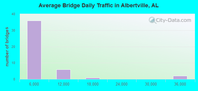
- 146,175Total average daily traffic
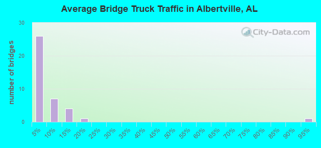
- 12,416Total average daily truck traffic
- 204,763Total future (year 2038) average daily traffic
- National Bridge Inventory (NBI) Registered Bridges for Albertville
- No street view available for this location
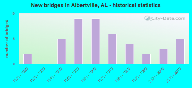
- New bridges - historical statistics
- 21920-1929
- 51940-1949
- 91950-1959
- 91960-1969
- 61970-1979
- 41980-1989
- 21990-1999
- 32000-2009
- 52010-2019
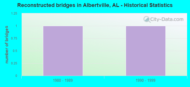
- Reconstructed bridges - Historical Statistics
- 11980-1989
- 11990-1999
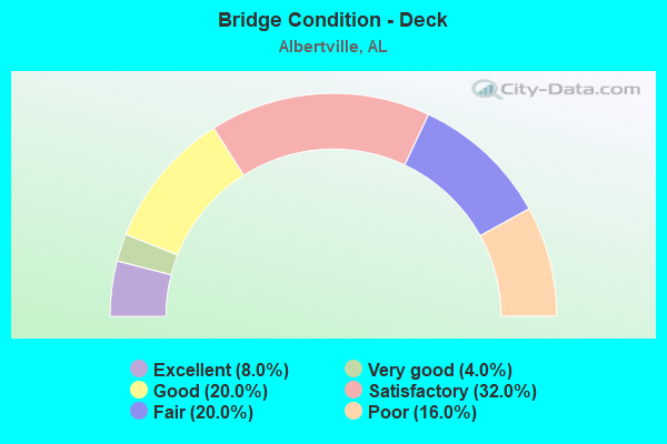
- Bridge Condition - Deck
- 8.0%Excellent
- 4.0%Very good
- 20.0%Good
- 32.0%Satisfactory
- 20.0%Fair
- 16.0%Poor
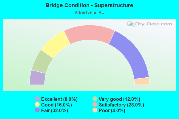
- Bridge Condition - Superstructure
- 8.0%Excellent
- 12.0%Very good
- 16.0%Good
- 28.0%Satisfactory
- 32.0%Fair
- 4.0%Poor
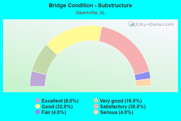
- Bridge Condition - Substructure
- 8.0%Excellent
- 16.0%Very good
- 32.0%Good
- 36.0%Satisfactory
- 4.0%Fair
- 4.0%Serious
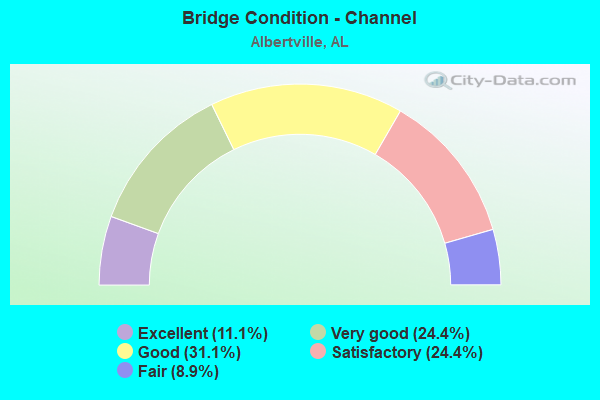
- Bridge Condition - Channel
- 11.1%Excellent
- 24.4%Very good
- 31.1%Good
- 24.4%Satisfactory
- 8.9%Fair
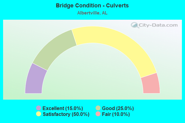
- Bridge Condition - Culverts
- 15.0%Excellent
- 25.0%Good
- 50.0%Satisfactory
- 10.0%Fair
Find on map >> Show street view
Structure Number: 18657, Location: 4042 FT S JCT 1161 (Lat: 34.246042, Lng: -86.294083), Route carried "on" structure: County highway 131, Year Built: 2015, Status: Open, Structure Length: 1.14m (3.74ft), Average Daily Traffic: 260 (year 2015), Truck Traffic: 5%, Average Future Daily Traffic: 386 (year 2040), Design Load: HS 20, Features Intersected: Little Hog Creek
Minimum Vertical Clearance: 30+ m (98+ ft), Kilometerpoint: 0.010, Lanes on structure: 2, Owner: County Highway Agency, Approaching Roadway Width: 9.1m (29.9ft), Material/Design: Concrete, Design/Construction: Culvert, Number Of Spans In Main Unit: 3, Length of Maximum Span: 3.8m (12.5ft), Curb-To-Curb Width: 6.1m (20.0ft), Out-to-Out Width: 12.9m (42.3ft)
Condition: Channel: Excellent, Culverts: Excellent, Operating Rating: 88.9 metric tons, Method Used To Determine Operating Rating: Load Factor (LF), Inventory Rating: 71.8 metric tons, Method Used To Determine Inventory Rating: Load Factor (LF), Structural Evaluation: Superior to present desirable criteria, Deck Geometry: Meets minimum limits, Waterway Adequacy: Superior to present desirable criteria, Approach Roadway Alignment: Better than present minimum criteria, Length Of Structure Improvement: 1.82m (5.97ft), Designated Inspection Frequency: Every 24 months, Inspection Date: July 2020, Bridge Improvement Cost: $441,000, Roadway Improvement Cost: $44,000, Total Project Cost: $485,000 ( Estimate for 2022), Deck Structure Type: Concrete Cast-file-Place, Wearing Surface/Protective System: Wearing Surface: Monolithic Concrete
Find on map >> Show street view
Structure Number: 19176, Location: 1/2 mile W SR75 (Lat: 34.297411, Lng: -86.179139), Route carried "on" structure: County highway 400, Year Built: 2017, Status: Open, Structure Length: 1.58m (5.18ft), Average Daily Traffic: 92 (year 2017), Truck Traffic: 1%, Average Future Daily Traffic: 137 (year 2040), Design Load: HS 20, Features Intersected: Turkey Creek
Minimum Vertical Clearance: 30+ m (98+ ft), Kilometerpoint: 0.010, Lanes on structure: 2, Owner: County Highway Agency, Approaching Roadway Width: 6.1m (20.0ft), Material/Design: Concrete, Design/Construction: Channel Beam, Number Of Spans In Main Unit: 1, Length of Maximum Span: 15.2m (49.9ft), Curb-To-Curb Width: 5.8m (19.0ft), Out-to-Out Width: 8.5m (27.9ft)
Condition: Deck: Excellent, Superstructure: Excellent, Substructure: Excellent, Channel: Excellent, Operating Rating: 74.6 metric tons, Method Used To Determine Operating Rating: Load Factor (LF), Inventory Rating: 44.6 metric tons, Method Used To Determine Inventory Rating: Load Factor (LF), Structural Evaluation: Superior to present desirable criteria, Deck Geometry: Meets minimum limits, Waterway Adequacy: Superior to present desirable criteria, Approach Roadway Alignment: Better than present minimum criteria, Length Of Structure Improvement: 2.27m (7.45ft), Designated Inspection Frequency: Every 24 months, Inspection Date: July 2020, Bridge Improvement Cost: $436,000, Roadway Improvement Cost: $44,000, Total Project Cost: $480,000 ( Estimate for 2022), Deck Structure Type: Concrete Precast Panels, Wearing Surface/Protective System: Wearing Surface: Bituminous
Find on map >> Show street view
Structure Number: 20348, Location: .9 MI N JCT SR68/SR75 (Lat: 34.306211, Lng: -86.131647), Route carried "on" structure: State highway 75, Year Built: 2015, Status: Open, Structure Length: 14.02m (46.00ft), Average Daily Traffic: 7,348 (year 2020), Truck Traffic: 5%, Average Future Daily Traffic: 10,287 (year 2040), Design Load: HS 20, Features Intersected: SCARHAM CREEK
Minimum Vertical Clearance: 30+ m (98+ ft), Kilometerpoint: 102.526, Lanes on structure: 2, Owner: State Highway Agency, Approaching Roadway Width: 13.1m (43.0ft), Material/Design: Prestressed concrete, Design/Construction: Stringer/Multi-beam, Number Of Spans In Main Unit: 4, Length of Maximum Span: 35.1m (115.2ft), Curb-To-Curb Width: 11.6m (38.1ft), Out-to-Out Width: 13.1m (43.0ft)
Condition: Deck: Good, Superstructure: Very good, Substructure: Good, Channel: Very good, Operating Rating: 88.9 metric tons, Method Used To Determine Operating Rating: Load Factor (LF), Inventory Rating: 48.3 metric tons, Method Used To Determine Inventory Rating: Load Factor (LF), Structural Evaluation: Better than present minimum criteria, Deck Geometry: High priority of replacement, Waterway Adequacy: Equal to present desirable criteria, Approach Roadway Alignment: Equal to present desirable criteria, Length Of Structure Improvement: 14.82m (48.62ft), Designated Inspection Frequency: Every 24 months, Inspection Date: January 2022, Bridge Improvement Cost: $4,369,000, Roadway Improvement Cost: $437,000, Total Project Cost: $4,806,000 ( Estimate for 2022), Deck Structure Type: Concrete Cast-file-Place, Wearing Surface/Protective System: Wearing Surface: Bituminous
Find on map >> Show street view
Structure Number: 20811, Location: 4500 FT N JCT 1414 (Lat: 34.325858, Lng: -86.166061), Route carried "on" structure: County highway 409, Year Built: 2015, Status: Open, Structure Length: 24.38m (79.99ft), Average Daily Traffic: 1,309 (year 2015), Truck Traffic: 1%, Average Future Daily Traffic: 1,945 (year 2040), Design Load: HS 20, Features Intersected: Scarham Creek
Minimum Vertical Clearance: 30+ m (98+ ft), Kilometerpoint: 0.010, Lanes on structure: 2, Owner: County Highway Agency, Approaching Roadway Width: 9.8m (32.2ft), Material/Design: Prestressed concrete, Design/Construction: Stringer/Multi-beam, Number Of Spans In Main Unit: 6, Length of Maximum Span: 41.1m (134.8ft), Curb-To-Curb Width: 7.3m (24.0ft), Out-to-Out Width: 12.1m (39.7ft)
Condition: Deck: Excellent, Superstructure: Excellent, Substructure: Excellent, Channel: Excellent, Operating Rating: 88.9 metric tons, Method Used To Determine Operating Rating: Load Factor (LF), Inventory Rating: 39.1 metric tons, Method Used To Determine Inventory Rating: Load Factor (LF), Structural Evaluation: Superior to present desirable criteria, Deck Geometry: Meets minimum limits, Waterway Adequacy: Superior to present desirable criteria, Approach Roadway Alignment: Better than present minimum criteria, Length Of Structure Improvement: 24.38m (79.99ft), Designated Inspection Frequency: Every 24 months, Inspection Date: July 2020, Bridge Improvement Cost: $6,521,000, Roadway Improvement Cost: $652,000, Total Project Cost: $7,173,000 ( Estimate for 2022), Deck Structure Type: Concrete Cast-file-Place, Wearing Surface/Protective System: Wearing Surface: Low Slump Concrete, Membrane: Epoxy
Find on map >> Show street view
Structure Number: 21401, Location: North JCT 431 (Lat: 34.299719, Lng: -86.246981), Route carried "on" structure: County highway 322, Year Built: 2018, Status: Open, Structure Length: 0.75m (2.46ft), Average Daily Traffic: 106 (year 2018), Truck Traffic: 1%, Average Future Daily Traffic: 158 (year 2041), Design Load: HS 20, Features Intersected: Drum Creek
Minimum Vertical Clearance: 30+ m (98+ ft), Kilometerpoint: 0.010, Lanes on structure: 2, Owner: County Highway Agency, Approaching Roadway Width: 7.3m (24.0ft), Material/Design: Concrete, Design/Construction: Culvert, Number Of Spans In Main Unit: 2, Length of Maximum Span: 3.7m (12.1ft), Curb-To-Curb Width: 6.1m (20.0ft), Out-to-Out Width: 8.8m (28.9ft)
Condition: Channel: Excellent, Culverts: Excellent, Operating Rating: 88.9 metric tons, Method Used To Determine Operating Rating: Load Factor (LF), Inventory Rating: 66.1 metric tons, Method Used To Determine Inventory Rating: Load Factor (LF), Structural Evaluation: Superior to present desirable criteria, Deck Geometry: Meets minimum limits, Waterway Adequacy: Superior to present desirable criteria, Approach Roadway Alignment: Superior to present desirable criteria, Length Of Structure Improvement: 1.40m (4.59ft), Designated Inspection Frequency: Every 24 months, Inspection Date: March 2021, Bridge Improvement Cost: $234,000, Roadway Improvement Cost: $23,000, Total Project Cost: $257,000 ( Estimate for 2022)