Bridge Statistics for Amarillo, Texas (TX)
Condition, Traffic, Stress, Structural Evaluation, Project Costs
- National Bridge Inventory (NBI) Statistics
- 302Number of bridges
- 4,334ft / 1,321mTotal length
- $13,526,000Total costs
- 4,122,957Total average daily traffic
- 496,612Total average daily truck traffic
- National Bridge Inventory (NBI) Registered Bridges for Amarillo
- No street view available for this location
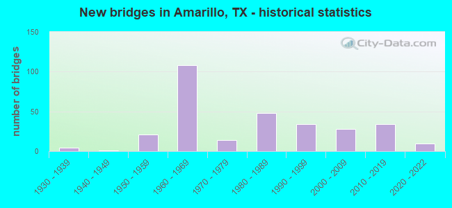
- New bridges - historical statistics
- 41930-1939
- 11940-1949
- 211950-1959
- 1081960-1969
- 141970-1979
- 481980-1989
- 341990-1999
- 282000-2009
- 342010-2019
- 102020-2022
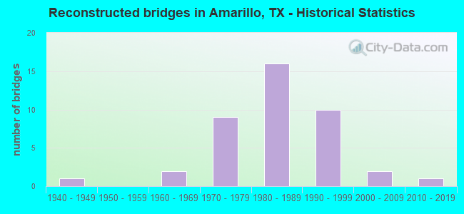
- Reconstructed bridges - Historical Statistics
- 11940-1949
- 01950-1959
- 21960-1969
- 91970-1979
- 161980-1989
- 101990-1999
- 22000-2009
- 12010-2019
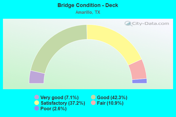
- Bridge Condition - Deck
- 7.1%Very good
- 42.3%Good
- 37.2%Satisfactory
- 10.9%Fair
- 2.6%Poor
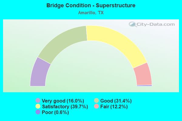
- Bridge Condition - Superstructure
- 16.0%Very good
- 31.4%Good
- 39.7%Satisfactory
- 12.2%Fair
- 0.6%Poor
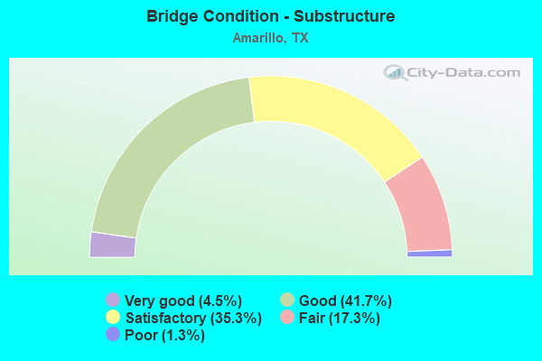
- Bridge Condition - Substructure
- 4.5%Very good
- 41.7%Good
- 35.3%Satisfactory
- 17.3%Fair
- 1.3%Poor
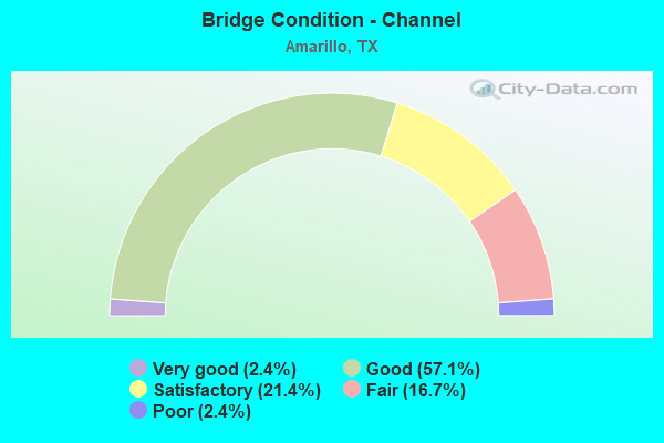
- Bridge Condition - Channel
- 2.4%Very good
- 57.1%Good
- 21.4%Satisfactory
- 16.7%Fair
- 2.4%Poor
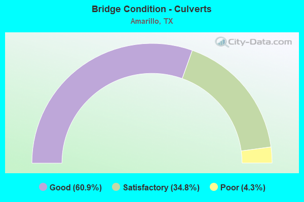
- Bridge Condition - Culverts
- 60.9%Good
- 34.8%Satisfactory
- 4.3%Poor
Find on map >> Show street view
Structure Number: 41910016809056, Location: 2.4 Mi NE of LP 335S (Lat: 35.146467, Lng: -101.886667), Route carried "on" structure: Interstate 27, Year Built: 1985, Status: Open, Structure Length: 5.15m (16.90ft), Average Daily Traffic: 13,105 (year 2019), Truck Traffic: 11%, Average Future Daily Traffic: 21,160 (year 2033), Design Load: HS 20, Features Intersected: Hillside Rd
Minimum Vertical Clearance: 30+ m (98+ ft), Kilometerpoint: 17.753, Lanes on structure: 2, Lanes under structure: 4, Owner: State Highway Agency, Approaching Roadway Width: 11.6m (38.1ft), Skew: 3 degrees, Material/Design: Prestressed concrete, Design/Construction: Stringer/Multi-beam, Number Of Spans In Main Unit: 1, Number Of Approach Spans: 2, Length of Maximum Span: 24.1m (79.1ft), Curb-To-Curb Width: 11.6m (38.1ft), Out-to-Out Width: 12.2m (40.0ft)
Condition: Deck: Good, Superstructure: Fair, Substructure: Good, Operating Rating: 54.4 metric tons, Method Used To Determine Operating Rating: Assigned rating based on Load Factor Design (LFD) reported in metric tons, Inventory Rating: 32.7 metric tons, Method Used To Determine Inventory Rating: Assigned rating based on Load Factor Design (LFD) reported in metric tons, Structural Evaluation: Somewhat better than minimum adequacy, Deck Geometry: Equal to present minimum criteria, Underclear: Meets minimum limits, Approach Roadway Alignment: Equal to present desirable criteria, Designated Inspection Frequency: Every 24 months, Inspection Date: October 2021, Deck Structure Type: Concrete Cast-file-Place, Wearing Surface/Protective System: Wearing Surface: Bituminous
Find on map >> Show street view
Structure Number: 41910016809057, Location: 2.4 Mi NE of LP 335S (Lat: 35.146386, Lng: -101.886353), Route carried "on" structure: ServiceState highway 27, Year Built: 1985, Status: Open, Structure Length: 4.85m (15.91ft), Average Daily Traffic: 2,730 (year 2013), Truck Traffic: 10%, Average Future Daily Traffic: 3,830 (year 2033), Design Load: HS 20, Features Intersected: Hillside Rd
Minimum Vertical Clearance: 30+ m (98+ ft), Kilometerpoint: 17.746, Lanes on structure: 2, Lanes under structure: 4, Owner: State Highway Agency, Approaching Roadway Width: 10.1m (33.1ft), Skew: 3 degrees, Material/Design: Prestressed concrete, Design/Construction: Stringer/Multi-beam, Number Of Spans In Main Unit: 1, Number Of Approach Spans: 2, Length of Maximum Span: 24.1m (79.1ft), Curb-To-Curb Width: 10.1m (33.1ft), Out-to-Out Width: 11.0m (36.1ft)
Condition: Deck: Good, Superstructure: Good, Substructure: Good, Operating Rating: 54.4 metric tons, Method Used To Determine Operating Rating: Assigned rating based on Load Factor Design (LFD) reported in metric tons, Inventory Rating: 32.7 metric tons, Method Used To Determine Inventory Rating: Assigned rating based on Load Factor Design (LFD) reported in metric tons, Structural Evaluation: Better than present minimum criteria, Deck Geometry: Somewhat better than minimum adequacy, Underclear: Meets minimum limits, Approach Roadway Alignment: Equal to present desirable criteria, Designated Inspection Frequency: Every 24 months, Inspection Date: October 2021, Deck Structure Type: Concrete Cast-file-Place, Wearing Surface/Protective System: Wearing Surface: Bituminous
Find on map >> Show street view
Structure Number: 41910016809061, Location: 1.0 MI S OF LP 335 (Lat: 35.102139, Lng: -101.912953), Route carried "on" structure: County highway 163, Year Built: 1986, Status: Open, Structure Length: 11.73m (38.48ft), Average Daily Traffic: 208 (year 2012), Average Future Daily Traffic: 100 (year 2032), Design Load: HS 20, Features Intersected: IH 27
Minimum Vertical Clearance: 30+ m (98+ ft), Kilometerpoint: 12.236, Lanes on structure: 2, Lanes under structure: 8, Owner: State Highway Agency, Approaching Roadway Width: 9.8m (32.2ft), Skew: 1 degrees, Material/Design: Prestressed concrete, Design/Construction: Stringer/Multi-beam, Number Of Spans In Main Unit: 4, Number Of Approach Spans: 2, Length of Maximum Span: 24.4m (80.1ft), Curb-To-Curb Width: 10.1m (33.1ft), Out-to-Out Width: 11.0m (36.1ft)
Condition: Deck: Good, Superstructure: Good, Substructure: Good, Operating Rating: 54.4 metric tons, Method Used To Determine Operating Rating: Assigned rating based on Load Factor Design (LFD) reported in metric tons, Inventory Rating: 32.7 metric tons, Method Used To Determine Inventory Rating: Assigned rating based on Load Factor Design (LFD) reported in metric tons, Structural Evaluation: Better than present minimum criteria, Deck Geometry: Better than present minimum criteria, Underclear: Equal to present minimum criteria, Approach Roadway Alignment: Equal to present desirable criteria, Designated Inspection Frequency: Every 24 months, Inspection Date: October 2021, Deck Structure Type: Concrete Precast Panels, Wearing Surface/Protective System: Wearing Surface: Bituminous
Find on map >> Show street view
Structure Number: 41910016809062, Location: 0.5 Mi E of FM 1541 (Lat: 35.178300, Lng: -101.841281), Route carried "on" structure: City street , Year Built: 1989, Status: Open, Structure Length: 5.70m (18.70ft), Average Daily Traffic: 10,575 (year 2012), Average Future Daily Traffic: 11,630 (year 2032), Design Load: HS 20, Features Intersected: IH 27, Facility Carried by Structure: SW 34th St
Minimum Vertical Clearance: 30+ m (98+ ft), Kilometerpoint: 9.011, Lanes on structure: 4, Lanes under structure: 6, Owner: State Highway Agency, Approaching Roadway Width: 14.0m (45.9ft), Skew: 3 degrees, Material/Design: Prestressed concrete, Design/Construction: Box Beam or Girders - Multiple, Number Of Spans In Main Unit: 2, Length of Maximum Span: 28.7m (94.2ft), Curb or Sidewalk Widths: Left: 1.1m (3.6ft), Right: 1.1m (3.6ft), Curb-To-Curb Width: 15.9m (52.2ft), Out-to-Out Width: 18.9m (62.0ft)
Condition: Deck: Satisfactory, Superstructure: Satisfactory, Substructure: Satisfactory, Operating Rating: 54.4 metric tons, Method Used To Determine Operating Rating: Assigned rating based on Load Factor Design (LFD) reported in metric tons, Inventory Rating: 32.7 metric tons, Method Used To Determine Inventory Rating: Assigned rating based on Load Factor Design (LFD) reported in metric tons, Structural Evaluation: Equal to present minimum criteria, Deck Geometry: Meets minimum limits, Underclear: High priority of corrective action, Approach Roadway Alignment: Equal to present desirable criteria, Length Of Structure Improvement: 5.70m (18.70ft), Designated Inspection Frequency: Every 24 months, Inspection Date: October 2021, Bridge Improvement Cost: $19,000, Roadway Improvement Cost: $5,000, Total Project Cost: $24,000, Deck Structure Type: Concrete Precast Panels
Find on map >> Show street view
Structure Number: 41910016809063, Location: 0.4 Mi E of FM 1541 (Lat: 35.177339, Lng: -101.842233), Route carried "on" structure: City street , Year Built: 1989, Status: Open, Structure Length: 5.79m (19.00ft), Average Daily Traffic: 5,000 (year 2012), Average Future Daily Traffic: 9,000 (year 2032), Design Load: HS 20, Features Intersected: IH 27, Facility Carried by Structure: Tyler St
Minimum Vertical Clearance: 30+ m (98+ ft), Kilometerpoint: 1.609, Lanes on structure: 3, Lanes under structure: 6, Owner: State Highway Agency, Approaching Roadway Width: 9.8m (32.2ft), Skew: 3 degrees, Material/Design: Prestressed concrete, Design/Construction: Box Beam or Girders - Multiple, Number Of Spans In Main Unit: 2, Length of Maximum Span: 28.7m (94.2ft), Curb or Sidewalk Widths: Left: 1.0m (3.3ft), Right: 1.0m (3.3ft), Curb-To-Curb Width: 12.2m (40.0ft), Out-to-Out Width: 15.2m (49.9ft)
Condition: Deck: Satisfactory, Superstructure: Satisfactory, Substructure: Fair, Operating Rating: 54.4 metric tons, Method Used To Determine Operating Rating: Assigned rating based on Load Factor Design (LFD) reported in metric tons, Inventory Rating: 32.7 metric tons, Method Used To Determine Inventory Rating: Assigned rating based on Load Factor Design (LFD) reported in metric tons, Structural Evaluation: Somewhat better than minimum adequacy, Deck Geometry: Meets minimum limits, Underclear: Meets minimum limits, Approach Roadway Alignment: Equal to present desirable criteria, Length Of Structure Improvement: 5.79m (19.00ft), Designated Inspection Frequency: Every 24 months, Inspection Date: October 2021, Deck Structure Type: Concrete Precast Panels
Find on map >> Show street view
Structure Number: 41910016809068, Location: 1.1 Mi SW of FM 1541 (Lat: 35.170011, Lng: -101.866228), Route carried "on" structure: Interstate 27, Year Built: 1961, Year Reconstructed: 1990, Status: Open, Structure Length: 8.99m (29.49ft), Average Daily Traffic: 25,225 (year 2019), Truck Traffic: 10%, Average Future Daily Traffic: 40,370 (year 2033), Features Intersected: Georgia St
Minimum Vertical Clearance: 30+ m (98+ ft), Kilometerpoint: 20.944, Lanes on structure: 3, Lanes under structure: 6, Owner: State Highway Agency, Approaching Roadway Width: 10.4m (34.1ft), Skew: 4 degrees, Material/Design: Steel continuous, Design/Construction: Stringer/Multi-beam, Number Of Spans In Main Unit: 4, Number Of Approach Spans: 2, Length of Maximum Span: 18.3m (60.0ft), Curb-To-Curb Width: 10.4m (34.1ft), Out-to-Out Width: 15.9m (52.2ft)
Condition: Deck: Good, Superstructure: Satisfactory, Substructure: Good, Operating Rating: 68.0 metric tons, Method Used To Determine Operating Rating: Load Factor (LF), Inventory Rating: 40.8 metric tons, Method Used To Determine Inventory Rating: Load Factor (LF), Structural Evaluation: Equal to present minimum criteria, Deck Geometry: High priority of replacement, Underclear: Meets minimum limits, Approach Roadway Alignment: Equal to present desirable criteria, Designated Inspection Frequency: Every 24 months, Inspection Date: October 2021, Deck Structure Type: Concrete Cast-file-Place, Wearing Surface/Protective System: Wearing Surface: Bituminous
Find on map >> Show street view
Structure Number: 41910016809069, Location: 0.4 Mi W of FM 1541 (Lat: 35.175508, Lng: -101.855208), Route carried "on" structure: Interstate 27, Year Built: 1958, Year Reconstructed: 1990, Status: Open, Structure Length: 6.49m (21.29ft), Average Daily Traffic: 25,225 (year 2019), Truck Traffic: 10%, Average Future Daily Traffic: 40,370 (year 2033), Features Intersected: Parker St
Minimum Vertical Clearance: 30+ m (98+ ft), Kilometerpoint: 0.000, Lanes on structure: 3, Lanes under structure: 4, Owner: State Highway Agency, Approaching Roadway Width: 10.4m (34.1ft), Skew: 2 degrees, Material/Design: Steel continuous, Design/Construction: Stringer/Multi-beam, Number Of Spans In Main Unit: 3, Length of Maximum Span: 22.9m (75.1ft), Curb-To-Curb Width: 10.4m (34.1ft), Out-to-Out Width: 15.9m (52.2ft)
Condition: Deck: Satisfactory, Superstructure: Satisfactory, Substructure: Satisfactory, Operating Rating: 66.2 metric tons, Method Used To Determine Operating Rating: Load Factor (LF), Inventory Rating: 39.9 metric tons, Method Used To Determine Inventory Rating: Load Factor (LF), Structural Evaluation: Equal to present minimum criteria, Deck Geometry: High priority of replacement, Underclear: Equal to present minimum criteria, Approach Roadway Alignment: Equal to present desirable criteria, Designated Inspection Frequency: Every 24 months, Inspection Date: October 2021, Deck Structure Type: Concrete Cast-file-Place, Wearing Surface/Protective System: Wearing Surface: Bituminous
Find on map >> Show street view
Structure Number: 4191001680907, Location: 1.5 Mi S of IH 40 (Lat: 35.176636, Lng: -101.848478), Route carried "on" structure: Interstate 27, Year Built: 1958, Year Reconstructed: 1990, Status: Open, Structure Length: 9.17m (30.09ft), Average Daily Traffic: 24,803 (year 2019), Truck Traffic: 10%, Average Future Daily Traffic: 40,370 (year 2033), Features Intersected: FM 1541 (Washington St)
Minimum Vertical Clearance: 30+ m (98+ ft), Kilometerpoint: 22.758, Lanes on structure: 3, Lanes under structure: 7, Owner: State Highway Agency, Approaching Roadway Width: 10.4m (34.1ft), Skew: 20 degrees, Material/Design: Steel continuous, Design/Construction: Stringer/Multi-beam, Number Of Spans In Main Unit: 5, Length of Maximum Span: 21.3m (69.9ft), Curb-To-Curb Width: 10.4m (34.1ft), Out-to-Out Width: 15.9m (52.2ft)
Condition: Deck: Good, Superstructure: Satisfactory, Substructure: Satisfactory, Operating Rating: 64.4 metric tons, Method Used To Determine Operating Rating: Load Factor (LF), Inventory Rating: 39.0 metric tons, Method Used To Determine Inventory Rating: Load Factor (LF), Structural Evaluation: Equal to present minimum criteria, Deck Geometry: High priority of replacement, Underclear: High priority of corrective action, Approach Roadway Alignment: Equal to present desirable criteria, Length Of Structure Improvement: 9.17m (30.09ft), Designated Inspection Frequency: Every 24 months, Inspection Date: October 2021, Bridge Improvement Cost: $30,000, Roadway Improvement Cost: $8,000, Total Project Cost: $38,000, Deck Structure Type: Concrete Cast-file-Place, Wearing Surface/Protective System: Wearing Surface: Bituminous
Find on map >> Show street view
Structure Number: 41910016809078, Location: 3.1 Mi S of LP 335 (Lat: 35.072072, Lng: -101.919114), Route carried "on" structure: Interstate 27, Year Built: 2005, Status: Open, Structure Length: 6.04m (19.82ft), Average Daily Traffic: 35,195 (year 2020), Truck Traffic: 12%, Average Future Daily Traffic: 51,360 (year 2033), Design Load: HL 93, Features Intersected: CR 278 (W McCormick Rd)
Minimum Vertical Clearance: 30+ m (98+ ft), Kilometerpoint: 8.853, Lanes on structure: 4, Lanes under structure: 4, Owner: State Highway Agency, Approaching Roadway Width: 24.4m (80.1ft), Skew: 31 degrees, Material/Design: Prestressed concrete, Design/Construction: Stringer/Multi-beam, Number Of Spans In Main Unit: 3, Length of Maximum Span: 20.4m (66.9ft), Curb-To-Curb Width: 34.1m (111.9ft), Out-to-Out Width: 35.4m (116.1ft)
Condition: Deck: Good, Superstructure: Good, Substructure: Good, Operating Rating: 54.4 metric tons, Method Used To Determine Operating Rating: Assigned ratings based on Load and Resistance Factor Design (LRFD) reported in metric tons, Inventory Rating: 32.7 metric tons, Method Used To Determine Inventory Rating: Assigned ratings based on Load and Resistance Factor Design (LRFD) reported in metric tons, Structural Evaluation: Better than present minimum criteria, Deck Geometry: Superior to present desirable criteria, Underclear: Better than present minimum criteria, Approach Roadway Alignment: Equal to present desirable criteria, Designated Inspection Frequency: Every 24 months, Inspection Date: July 2020, Deck Structure Type: Concrete Precast Panels, Wearing Surface/Protective System: Wearing Surface: Other, Membrane: Other, Deck Protection: Epoxy Coated Reinforcing
Find on map >> Show street view
Structure Number: 41910016809171, Location: 0.4 Mi W of Bell St (Lat: 35.116417, Lng: -101.909511), Route carried "on" structure: Interstate 27, Year Built: 2021, Status: Open, Structure Length: 14.63m (48.00ft), Average Daily Traffic: 43,700 (year 2014), Average Future Daily Traffic: 57,800 (year 2035), Design Load: HL 93, Features Intersected: South LP 335
Minimum Vertical Clearance: 30+ m (98+ ft), Kilometerpoint: 13.969, Lanes on structure: 2, Lanes under structure: 4, Base Highway Network: Yes, Owner: State Highway Agency, Approaching Roadway Width: 11.6m (38.1ft), Skew: 9 degrees, Material/Design: Prestressed concrete, Design/Construction: Stringer/Multi-beam, Number Of Spans In Main Unit: 6, Length of Maximum Span: 25.3m (83.0ft), Curb-To-Curb Width: 11.6m (38.1ft), Out-to-Out Width: 12.2m (40.0ft)
Condition: Deck: Good, Superstructure: Good, Substructure: Very good, Operating Rating: 54.4 metric tons, Method Used To Determine Operating Rating: Assigned ratings based on Load and Resistance Factor Design (LRFD) reported in metric tons, Inventory Rating: 32.7 metric tons, Method Used To Determine Inventory Rating: Assigned ratings based on Load and Resistance Factor Design (LRFD) reported in metric tons, Structural Evaluation: Better than present minimum criteria, Deck Geometry: Equal to present minimum criteria, Underclear: Meets minimum limits, Approach Roadway Alignment: Equal to present desirable criteria, Designated Inspection Frequency: Every 24 months, Inspection Date: March 2021, Deck Structure Type: Concrete Precast Panels, Wearing Surface/Protective System: Wearing Surface: Monolithic Concrete, Deck Protection: Epoxy Coated Reinforcing
Find on map >> Show street view
Structure Number: 41910148002003, Location: 1.8 Mi N of LP 335 (Lat: 35.146289, Lng: -101.849064), Route carried "on" structure: State highway 1541, Year Built: 1995, Status: Open, Structure Length: 11.28m (37.01ft), Average Daily Traffic: 11,228 (year 2020), Truck Traffic: 12%, Average Future Daily Traffic: 13,990 (year 2033), Design Load: HS 20, Features Intersected: BNSF Railroad
Minimum Vertical Clearance: 30+ m (98+ ft), Kilometerpoint: 4.991, Lanes on structure: 5, Owner: State Highway Agency, Approaching Roadway Width: 20.1m (65.9ft), Skew: 6 degrees, Material/Design: Prestressed concrete, Design/Construction: Stringer/Multi-beam, Number Of Spans In Main Unit: 1, Number Of Approach Spans: 4, Length of Maximum Span: 29.0m (95.1ft), Curb-To-Curb Width: 19.9m (65.3ft), Out-to-Out Width: 20.7m (67.9ft)
Condition: Deck: Satisfactory, Superstructure: Good, Substructure: Good, Operating Rating: 54.4 metric tons, Method Used To Determine Operating Rating: Assigned rating based on Load Factor Design (LFD) reported in metric tons, Inventory Rating: 32.7 metric tons, Method Used To Determine Inventory Rating: Assigned rating based on Load Factor Design (LFD) reported in metric tons, Structural Evaluation: Better than present minimum criteria, Deck Geometry: Meets minimum limits, Underclear: Somewhat better than minimum adequacy, Approach Roadway Alignment: Equal to present desirable criteria, Length Of Structure Improvement: 11.31m (37.11ft), Designated Inspection Frequency: Every 24 months, Inspection Date: October 2021, Deck Structure Type: Concrete Cast-file-Place
Find on map >> Show street view
Structure Number: 41910263502024, Location: 3.5 Mi E of IH 27 (Lat: 35.120372, Lng: -101.848292), Route carried "on" structure: State highway 335, Year Built: 1989, Status: Open, Structure Length: 7.01m (23.00ft), Average Daily Traffic: 9,121 (year 2020), Truck Traffic: 26%, Average Future Daily Traffic: 14,050 (year 2033), Design Load: HS 20, Features Intersected: FM 1541 (Washington St)
Minimum Vertical Clearance: 30+ m (98+ ft), Kilometerpoint: 16.063, Lanes on structure: 2, Lanes under structure: 4, Owner: State Highway Agency, Approaching Roadway Width: 13.4m (44.0ft), Material/Design: Prestressed concrete, Design/Construction: Stringer/Multi-beam, Number Of Spans In Main Unit: 2, Number Of Approach Spans: 1, Length of Maximum Span: 27.4m (89.9ft), Curb-To-Curb Width: 13.2m (43.3ft), Out-to-Out Width: 14.0m (45.9ft)
Condition: Deck: Satisfactory, Superstructure: Good, Substructure: Satisfactory, Operating Rating: 54.4 metric tons, Method Used To Determine Operating Rating: Assigned rating based on Load Factor Design (LFD) reported in metric tons, Inventory Rating: 32.7 metric tons, Method Used To Determine Inventory Rating: Assigned rating based on Load Factor Design (LFD) reported in metric tons, Structural Evaluation: Equal to present minimum criteria, Deck Geometry: Somewhat better than minimum adequacy, Underclear: Better than present minimum criteria, Approach Roadway Alignment: Equal to present desirable criteria, Designated Inspection Frequency: Every 24 months, Inspection Date: October 2021, Deck Structure Type: Concrete Precast Panels, Wearing Surface/Protective System: Wearing Surface: Bituminous
Find on map >> Show street view
Structure Number: 41910263502025, Location: 2.0 Mi E of FM 1541 (Lat: 35.120447, Lng: -101.813039), Route carried "on" structure: State highway 335, Year Built: 1989, Status: Open, Structure Length: 6.40m (21.00ft), Average Daily Traffic: 9,121 (year 2020), Truck Traffic: 3%, Average Future Daily Traffic: 12,740 (year 2033), Design Load: HS 20, Features Intersected: Osage St
Minimum Vertical Clearance: 30+ m (98+ ft), Kilometerpoint: 12.836, Lanes on structure: 2, Lanes under structure: 3, Owner: State Highway Agency, Approaching Roadway Width: 13.4m (44.0ft), Material/Design: Prestressed concrete, Design/Construction: Stringer/Multi-beam, Number Of Spans In Main Unit: 1, Number Of Approach Spans: 2, Length of Maximum Span: 27.4m (89.9ft), Curb-To-Curb Width: 13.2m (43.3ft), Out-to-Out Width: 14.0m (45.9ft)
Condition: Deck: Satisfactory, Superstructure: Good, Substructure: Good, Operating Rating: 54.4 metric tons, Method Used To Determine Operating Rating: Assigned rating based on Load Factor Design (LFD) reported in metric tons, Inventory Rating: 32.7 metric tons, Method Used To Determine Inventory Rating: Assigned rating based on Load Factor Design (LFD) reported in metric tons, Structural Evaluation: Better than present minimum criteria, Deck Geometry: Somewhat better than minimum adequacy, Underclear: Superior to present desirable criteria, Approach Roadway Alignment: Equal to present desirable criteria, Length Of Structure Improvement: 6.40m (21.00ft), Designated Inspection Frequency: Every 24 months, Inspection Date: October 2021, Deck Structure Type: Concrete Precast Panels, Wearing Surface/Protective System: Wearing Surface: Bituminous
Find on map >> Show street view
Structure Number: 41910263502084, Location: 2.5 MI E of IH 27 (Lat: 35.120178, Lng: -101.866017), Route carried "on" structure: State highway 335, Year Built: 2017, Status: Open, Structure Length: 6.86m (22.51ft), Average Daily Traffic: 14,761 (year 2020), Truck Traffic: 26%, Average Future Daily Traffic: 14,500 (year 2036), Design Load: HL 93, Features Intersected: Georgia St
Minimum Vertical Clearance: 30+ m (98+ ft), Kilometerpoint: 16.972, Lanes on structure: 4, Lanes under structure: 5, Base Highway Network: Yes, Owner: State Highway Agency, Approaching Roadway Width: 23.2m (76.1ft), Skew: 30 degrees, Material/Design: Prestressed concrete, Design/Construction: Stringer/Multi-beam, Number Of Spans In Main Unit: 1, Number Of Approach Spans: 2, Length of Maximum Span: 29.0m (95.1ft), Curb-To-Curb Width: 23.7m (77.8ft), Out-to-Out Width: 25.0m (82.0ft)
Condition: Deck: Good, Superstructure: Very good, Substructure: Good, Operating Rating: 54.4 metric tons, Method Used To Determine Operating Rating: Assigned ratings based on Load and Resistance Factor Design (LRFD) reported in metric tons, Inventory Rating: 32.7 metric tons, Method Used To Determine Inventory Rating: Assigned ratings based on Load and Resistance Factor Design (LRFD) reported in metric tons, Structural Evaluation: Better than present minimum criteria, Deck Geometry: Superior to present desirable criteria, Underclear: Superior to present desirable criteria, Approach Roadway Alignment: Equal to present desirable criteria, Designated Inspection Frequency: Every 24 months, Inspection Date: October 2021, Deck Structure Type: Concrete Precast Panels
Find on map >> Show street view
Structure Number: 41910263502085, Location: 1.4 MI E of IH 27 (Lat: 35.117208, Lng: -101.883717), Route carried "on" structure: State highway 335, Year Built: 2017, Status: Open, Structure Length: 7.77m (25.49ft), Average Daily Traffic: 9,700 (year 2013), Truck Traffic: 19%, Average Future Daily Traffic: 14,600 (year 2033), Design Load: HL 93, Features Intersected: Western St
Minimum Vertical Clearance: 30+ m (98+ ft), Kilometerpoint: 18.710, Lanes on structure: 3, Lanes under structure: 6, Owner: State Highway Agency, Approaching Roadway Width: 23.2m (76.1ft), Skew: 30 degrees, Material/Design: Prestressed concrete, Design/Construction: Stringer/Multi-beam, Number Of Spans In Main Unit: 1, Number Of Approach Spans: 2, Length of Maximum Span: 29.0m (95.1ft), Curb-To-Curb Width: 23.7m (77.8ft), Out-to-Out Width: 25.0m (82.0ft)
Condition: Deck: Good, Superstructure: Very good, Substructure: Good, Operating Rating: 54.4 metric tons, Method Used To Determine Operating Rating: Assigned ratings based on Load and Resistance Factor Design (LRFD) reported in metric tons, Inventory Rating: 32.7 metric tons, Method Used To Determine Inventory Rating: Assigned ratings based on Load and Resistance Factor Design (LRFD) reported in metric tons, Structural Evaluation: Better than present minimum criteria, Deck Geometry: Superior to present desirable criteria, Underclear: Superior to present desirable criteria, Approach Roadway Alignment: Equal to present desirable criteria, Designated Inspection Frequency: Every 24 months, Inspection Date: October 2021, Deck Structure Type: Concrete Precast Panels
Find on map >> Show street view
Structure Number: 41910263502086, Location: 2.9 MI E OF IH 27 (Lat: 35.120044, Lng: -101.858650), Route carried "on" structure: State highway 335, Year Built: 2017, Status: Open, Structure Length: 16.61m (54.49ft), Average Daily Traffic: 9,700 (year 2013), Truck Traffic: 25%, Average Future Daily Traffic: 14,600 (year 2033), Design Load: HL 93, Features Intersected: BNSF RR / Frontage Rd
Minimum Vertical Clearance: 30+ m (98+ ft), Kilometerpoint: 16.380, Lanes on structure: 3, Owner: State Highway Agency, Approaching Roadway Width: 15.5m (50.9ft), Skew: 1 degrees, Material/Design: Steel continuous, Design/Construction: Stringer/Multi-beam, Number Of Spans In Main Unit: 3, Length of Maximum Span: 68.6m (225.1ft), Curb-To-Curb Width: 15.5m (50.9ft), Out-to-Out Width: 16.5m (54.1ft)
Condition: Deck: Good, Superstructure: Very good, Substructure: Good, Operating Rating: 54.4 metric tons, Method Used To Determine Operating Rating: Assigned ratings based on Load and Resistance Factor Design (LRFD) reported in metric tons, Inventory Rating: 32.7 metric tons, Method Used To Determine Inventory Rating: Assigned ratings based on Load and Resistance Factor Design (LRFD) reported in metric tons, Structural Evaluation: Better than present minimum criteria, Deck Geometry: Equal to present minimum criteria, Underclear: Superior to present desirable criteria, Approach Roadway Alignment: Equal to present desirable criteria, Designated Inspection Frequency: Every 24 months, Inspection Date: October 2021, Deck Structure Type: Concrete Cast-file-Place
Find on map >> Show street view
Structure Number: 41910263502087, Location: 2.9 MI E of IH 27 (Lat: 35.120244, Lng: -101.858628), Route carried "on" structure: State highway 335, Year Built: 2017, Status: Open, Structure Length: 16.61m (54.49ft), Average Daily Traffic: 7,234 (year 2020), Truck Traffic: 25%, Average Future Daily Traffic: 14,600 (year 2033), Design Load: HL 93, Features Intersected: BNSF RR & FR T Around
Minimum Vertical Clearance: 30+ m (98+ ft), Kilometerpoint: 16.380, Lanes on structure: 3, Owner: State Highway Agency, Approaching Roadway Width: 15.5m (50.9ft), Skew: 1 degrees, Material/Design: Steel continuous, Design/Construction: Stringer/Multi-beam, Number Of Spans In Main Unit: 3, Length of Maximum Span: 68.6m (225.1ft), Curb-To-Curb Width: 15.5m (50.9ft), Out-to-Out Width: 15.8m (51.8ft)
Condition: Deck: Good, Superstructure: Very good, Substructure: Good, Operating Rating: 54.4 metric tons, Method Used To Determine Operating Rating: Assigned ratings based on Load and Resistance Factor Design (LRFD) reported in metric tons, Inventory Rating: 32.7 metric tons, Method Used To Determine Inventory Rating: Assigned ratings based on Load and Resistance Factor Design (LRFD) reported in metric tons, Structural Evaluation: Better than present minimum criteria, Deck Geometry: Equal to present minimum criteria, Underclear: Superior to present desirable criteria, Approach Roadway Alignment: Equal to present desirable criteria, Designated Inspection Frequency: Every 24 months, Inspection Date: October 2021, Deck Structure Type: Concrete Cast-file-Place
Find on map >> Show street view
Structure Number: 4191080170402, Location: 0.13 MI E OF IH 27 (Lat: 35.178411, Lng: -101.838542), Route carried "on" structure: City street , Year Built: 1983, Status: Open, Structure Length: 33.01m (108.30ft), Average Daily Traffic: 15,848 (year 2020), Average Future Daily Traffic: 14,619 (year 2036), Design Load: HS 20, Features Intersected: BNSF Airpark Dr Fillmore, Facility Carried by Structure: 34th Ave
Minimum Vertical Clearance: 30+ m (98+ ft), Kilometerpoint: 5.935, Lanes on structure: 4, Lanes under structure: 3, Owner: City or Municipal Highway Agency, Approaching Roadway Width: 15.9m (52.2ft), Skew: 1 degrees, Material/Design: Prestressed concrete, Design/Construction: Stringer/Multi-beam, Number Of Spans In Main Unit: 2, Number Of Approach Spans: 10, Length of Maximum Span: 39.3m (128.9ft), Curb-To-Curb Width: 15.6m (51.2ft), Out-to-Out Width: 16.5m (54.1ft)
Condition: Deck: Satisfactory, Superstructure: Fair, Substructure: Fair, Operating Rating: 54.4 metric tons, Method Used To Determine Operating Rating: Assigned rating based on Load Factor Design (LFD) reported in metric tons, Inventory Rating: 32.7 metric tons, Method Used To Determine Inventory Rating: Assigned rating based on Load Factor Design (LFD) reported in metric tons, Structural Evaluation: Somewhat better than minimum adequacy, Deck Geometry: Meets minimum limits, Underclear: Somewhat better than minimum adequacy, Approach Roadway Alignment: Equal to present desirable criteria, Length Of Structure Improvement: 33.01m (108.30ft), Designated Inspection Frequency: Every 24 months, Inspection Date: July 2020, Bridge Improvement Cost: $110,000, Roadway Improvement Cost: $28,000, Total Project Cost: $138,000, Deck Structure Type: Concrete Cast-file-Place, Wearing Surface/Protective System: Wearing Surface: Bituminous
Find on map >> Show street view
Structure Number: 40330027502086, Location: 2.1 Mi E of FM 1912 (Lat: 35.210172, Lng: -101.615511), Route carried "under" structure: Interstate 40, Year Built: 1968, Structure Length: 0. m, Average Daily Traffic: 11,880 (year 2013), Truck Traffic: 32%, Features Intersected: IH 40, Facility Carried by Structure: CR 252
Minimum Vertical Clearance: 5.31m (17.42ft), Kilometerpoint: 0.930, Lanes on structure: 2, Lanes under structure: 4, Material/Design: Prestressed concrete, Design/Construction: Stringer/Multi-beam, Length of Maximum Span: 26.5m (86.9ft)
Find on map >> Show street view
Structure Number: 40330027502186, Location: 4.9mi E. of 188/033 CO li (Lat: 35.221189, Lng: -101.543025), Route carried "under" structure: State highway 2373, Year Built: 2020, Structure Length: 0. m, Average Daily Traffic: 2,700 (year 2019), Truck Traffic: 13%, Features Intersected: IH 40
Minimum Vertical Clearance: 5.49m (18.01ft), Kilometerpoint: 23.801, Lanes on structure: 2, Lanes under structure: 4, Material/Design: Prestressed concrete, Design/Construction: Box Beam or Girders - Multiple, Length of Maximum Span: 27.4m (89.9ft)
Find on map >> Show street view
Structure Number: 41880004107025, Location: 1.3 MI N OF IH 40 (Lat: 35.214025, Lng: -101.834436), Route carried "under" structure: City street , Year Built: 1961, Structure Length: 0. m, Average Daily Traffic: 500 (year 2012), Truck Traffic: 3%, Features Intersected: City Streets & RR, Facility Carried by Structure: US 60 SB
Minimum Vertical Clearance: 5.13m (16.83ft), Kilometerpoint: 0.161, Lanes on structure: 3, Lanes under structure: 4, Material/Design: Steel continuous, Design/Construction: Stringer/Multi-beam, Length of Maximum Span: 26.5m (86.9ft)
Find on map >> Show street view
Structure Number: 41880004107027, Location: At Pierce St. Undercross (Lat: 35.227258, Lng: -101.831022), Route carried "under" structure: County highway , Year Built: 1963, Structure Length: 0. m, Average Daily Traffic: 5,000 (year 2011), Truck Traffic: 30%, Features Intersected: Pierce St Connector, Facility Carried by Structure: US 87 NB(Fillmore)
Minimum Vertical Clearance: 4.70m (15.42ft), Kilometerpoint: 0.000, Lanes on structure: 1, Lanes under structure: 2, Material/Design: Steel continuous, Design/Construction: Stringer/Multi-beam, Length of Maximum Span: 23.8m (78.1ft)
Find on map >> Show street view
Structure Number: 41880004107032, Location: 0.5 MI S OF LP 335 (Lat: 35.258261, Lng: -101.833436), Route carried "under" structure: County highway , Year Built: 1965, Structure Length: 0. m, Average Daily Traffic: 2,000 (year 2011), Truck Traffic: 30%, Features Intersected: Central Ave, Facility Carried by Structure: US 87 NB
Minimum Vertical Clearance: 4.67m (15.32ft), Kilometerpoint: 0.000, Lanes on structure: 2, Lanes under structure: 4, Material/Design: Steel continuous, Design/Construction: Stringer/Multi-beam, Length of Maximum Span: 18.9m (62.0ft)
Find on map >> Show street view
Structure Number: 41880004107033, Location: 0.5 MI S OF LP 335 (Lat: 35.258258, Lng: -101.833661), Route carried "under" structure: County highway , Year Built: 1965, Structure Length: 0. m, Average Daily Traffic: 2,000 (year 2011), Truck Traffic: 30%, Features Intersected: Central Ave, Facility Carried by Structure: US 87 SB
Minimum Vertical Clearance: 5.05m (16.57ft), Kilometerpoint: 0.000, Lanes on structure: 2, Lanes under structure: 4, Material/Design: Steel continuous, Design/Construction: Stringer/Multi-beam, Length of Maximum Span: 18.9m (62.0ft)
Find on map >> Show street view
Structure Number: 41880004107035, Location: 1.0 MI S OF LP 335 (Lat: 35.250722, Lng: -101.833372), Route carried "under" structure: County highway , Year Built: 1965, Structure Length: 0. m, Average Daily Traffic: 2,000 (year 2011), Truck Traffic: 30%, Features Intersected: Hastings Ave, Facility Carried by Structure: US 87 NB
Minimum Vertical Clearance: 4.95m (16.24ft), Kilometerpoint: 0.000, Lanes on structure: 2, Lanes under structure: 4, Material/Design: Steel continuous, Design/Construction: Stringer/Multi-beam, Length of Maximum Span: 18.9m (62.0ft)
Find on map >> Show street view
Structure Number: 41880004107036, Location: 1.0 MI S OF LP 335 (Lat: 35.250719, Lng: -101.833594), Route carried "under" structure: County highway , Year Built: 1965, Structure Length: 0. m, Average Daily Traffic: 30 (year 2011), Truck Traffic: 30%, Features Intersected: Hastings Ave, Facility Carried by Structure: US 87 SB
Minimum Vertical Clearance: 5.66m (18.57ft), Kilometerpoint: 0.000, Lanes on structure: 2, Lanes under structure: 4, Material/Design: Steel continuous, Design/Construction: Stringer/Multi-beam, Length of Maximum Span: 18.9m (62.0ft)
Find on map >> Show street view
Structure Number: 41880004107055, Location: 1.4 MI N OF IH 40 (Lat: 35.213450, Lng: -101.833319), Route carried "under" structure: US 60, Year Built: 1931, Structure Length: 0. m, Average Daily Traffic: 36,570 (year 2013), Truck Traffic: 38%, Features Intersected: US 60 NB (Fillmore St), Facility Carried by Structure: North First Ave
Minimum Vertical Clearance: 4.95m (16.24ft), Kilometerpoint: 3.402, Lanes on structure: 2, Lanes under structure: 2, Material/Design: Concrete, Design/Construction: Slab, Length of Maximum Span: 7.3m (24.0ft)
Find on map >> Show street view
Structure Number: 41880004107068, Location: 1.3 MI N of IH 40 (Lat: 35.214733, Lng: -101.831756), Route carried "under" structure: City street , Year Built: 1996, Structure Length: 0. m, Average Daily Traffic: 500 (year 2012), Truck Traffic: 3%, Features Intersected: BNSF Railyard, Facility Carried by Structure: US 60 SB (Pierce)
Minimum Vertical Clearance: 5.13m (16.83ft), Kilometerpoint: 17.881, Lanes on structure: 3, Lanes under structure: 4, Material/Design: Prestressed concrete, Design/Construction: Stringer/Multi-beam, Length of Maximum Span: 30.5m (100.1ft)
Find on map >> Show street view
Structure Number: 41880004107069, Location: 2.4 MI N OF IH 40 (Lat: 35.229458, Lng: -101.831439), Route carried "under" structure: County highway , Year Built: 1996, Structure Length: 0. m, Average Daily Traffic: 2,000 (year 2015), Truck Traffic: 30%, Features Intersected: North 15th Ave, Facility Carried by Structure: US 87 SB (287 SB)
Minimum Vertical Clearance: 5.05m (16.57ft), Kilometerpoint: 0.000, Lanes on structure: 3, Lanes under structure: 2, Material/Design: Prestressed concrete, Design/Construction: Box Beam or Girders - Multiple, Length of Maximum Span: 16.8m (55.1ft)
Find on map >> Show street view
Structure Number: 4188000410707, Location: 2,4 MI N OF IH 40 (Lat: 35.229081, Lng: -101.830772), Route carried "under" structure: County highway , Year Built: 1996, Structure Length: 0. m, Average Daily Traffic: 2,000 (year 2015), Truck Traffic: 30%, Features Intersected: North 15th Ave, Facility Carried by Structure: US 87 NB (287 NB)
Minimum Vertical Clearance: 4.98m (16.34ft), Kilometerpoint: 0.000, Lanes on structure: 3, Lanes under structure: 2, Material/Design: Prestressed concrete, Design/Construction: Box Beam or Girders - Multiple, Length of Maximum Span: 16.8m (55.1ft)
Find on map >> Show street view
Structure Number: 41880004107082, Location: 1.0 Mi N of BI 40 (Lat: 35.236383, Lng: -101.831575), Route carried "under" structure: US 87, Year Built: 2009, Structure Length: 0. m, Average Daily Traffic: 17,890 (year 2013), Truck Traffic: 7%, Features Intersected: US 87 / 287, Facility Carried by Structure: 24th St
Minimum Vertical Clearance: 4.78m (15.68ft), Kilometerpoint: 47.398, Lanes on structure: 4, Lanes under structure: 6, Material/Design: Prestressed concrete, Design/Construction: Box Beam or Girders - Multiple, Length of Maximum Span: 17.4m (57.1ft)
Find on map >> Show street view
Structure Number: 41880004107083, Location: 1.4mi S of Lp 335 (Lat: 35.245906, Lng: -101.832047), Route carried "under" structure: US 87, Year Built: 2012, Structure Length: 0. m, Average Daily Traffic: 5,000 (year 2011), Truck Traffic: 10%, Features Intersected: US 87 / 287, Facility Carried by Structure: LP 434 ( Park St.)
Minimum Vertical Clearance: 4.95m (16.24ft), Kilometerpoint: 46.362, Lanes on structure: 1, Lanes under structure: 4, Material/Design: Prestressed concrete, Design/Construction: Box Beam or Girders - Multiple, Length of Maximum Span: 19.8m (65.0ft)
Find on map >> Show street view
Structure Number: 41880004107084, Location: 5.2 Mi N of IH 40 (Lat: 35.265397, Lng: -101.833403), Route carried "under" structure: State highway 335, Year Built: 2013, Structure Length: 0. m, Average Daily Traffic: 13,300 (year 2011), Truck Traffic: 14%, Features Intersected: SLP 335, Facility Carried by Structure: US 87 NB
Minimum Vertical Clearance: 5.01m (16.44ft), Kilometerpoint: 20.258, Lanes on structure: 2, Lanes under structure: 7, Material/Design: Prestressed concrete, Design/Construction: Stringer/Multi-beam, Length of Maximum Span: 19.8m (65.0ft)
Find on map >> Show street view
Structure Number: 41880004107085, Location: 5.2 Mi N of IH 40 (Lat: 35.265894, Lng: -101.833650), Route carried "under" structure: State highway 335, Year Built: 2013, Structure Length: 0. m, Average Daily Traffic: 13,330 (year 2011), Truck Traffic: 15%, Features Intersected: SLP 335, Facility Carried by Structure: US 87 SB
Minimum Vertical Clearance: 5.03m (16.50ft), Kilometerpoint: 42.863, Lanes on structure: 2, Lanes under structure: 6, Material/Design: Prestressed concrete, Design/Construction: Stringer/Multi-beam, Length of Maximum Span: 19.8m (65.0ft)
Find on map >> Show street view
Structure Number: 41880004107086, Location: 1 mi N. of SLP 335 (Lat: 35.279903, Lng: -101.833464), Route carried "under" structure: City street , Year Built: 2013, Structure Length: 0. m, Average Daily Traffic: 1,000 (year 2012), Truck Traffic: 10%, Features Intersected: Willow Creek Ave, Facility Carried by Structure: US 87/ 287 NB
Minimum Vertical Clearance: 5.11m (16.77ft), Kilometerpoint: 1.609, Lanes on structure: 2, Lanes under structure: 2, Material/Design: Prestressed concrete, Design/Construction: Stringer/Multi-beam, Length of Maximum Span: 22.9m (75.1ft)
Find on map >> Show street view
Structure Number: 41880004107087, Location: 1 mi N. of SLP 335 (Lat: 35.279958, Lng: -101.833703), Route carried "under" structure: City street , Year Built: 2013, Structure Length: 0. m, Average Daily Traffic: 1,000 (year 2012), Truck Traffic: 10%, Features Intersected: Willow Creek Ave, Facility Carried by Structure: US 87 / 287 SB
Minimum Vertical Clearance: 5.11m (16.77ft), Kilometerpoint: 1.609, Lanes on structure: 2, Lanes under structure: 2, Material/Design: Prestressed concrete, Design/Construction: Stringer/Multi-beam, Length of Maximum Span: 22.9m (75.1ft)
Structure Number: 41880004107088, Location: 2.0 Mi N of LP 335, Route carried "under" structure: City street , Year Built: 2013, Structure Length: 0. m, Average Daily Traffic: 1,200 (year 2010), Truck Traffic: 7%, Features Intersected: Cherry Ave, Facility Carried by Structure: US 87 NB
Minimum Vertical Clearance: 5.03m (16.50ft), Material/Design: Prestressed concrete, Design/Construction: Stringer/Multi-beam, Length of Maximum Span: 22.9m (75.1ft)
Minimum Vertical Clearance: 5.03m (16.50ft), Material/Design: Prestressed concrete, Design/Construction: Stringer/Multi-beam, Length of Maximum Span: 22.9m (75.1ft)
Find on map >> Show street view
Structure Number: 4188000410709, Location: 4mi. N of LP 335 (Lat: 35.323825, Lng: -101.831417), Route carried "under" structure: State highway 1719, Year Built: 2014, Structure Length: 0. m, Average Daily Traffic: 1,000 (year 2012), Truck Traffic: 11%, Features Intersected: FM 1719, Facility Carried by Structure: US 87 NB
Minimum Vertical Clearance: 5.01m (16.44ft), Kilometerpoint: 1.658, Lanes on structure: 2, Lanes under structure: 2, Material/Design: Prestressed concrete, Design/Construction: Stringer/Multi-beam, Length of Maximum Span: 22.9m (75.1ft)
Find on map >> Show street view
Structure Number: 41880004107091, Location: 4Mi. N. of LP 335 (Lat: 35.320017, Lng: -101.831706), Route carried "under" structure: State highway 1719, Year Built: 2014, Structure Length: 0. m, Average Daily Traffic: 1,000 (year 2012), Truck Traffic: 11%, Features Intersected: FM 1719, Facility Carried by Structure: US 87 SB
Minimum Vertical Clearance: 5.01m (16.44ft), Kilometerpoint: 1.658, Lanes on structure: 2, Lanes under structure: 2, Material/Design: Prestressed concrete, Design/Construction: Stringer/Multi-beam, Length of Maximum Span: 22.9m (75.1ft)
Find on map >> Show street view
Structure Number: 41880004107093, Location: 2.9 mi N. of SLP 335 (Lat: 35.308947, Lng: -101.833675), Route carried "under" structure: US 87, Year Built: 2013, Structure Length: 0. m, Average Daily Traffic: 1,200 (year 2010), Truck Traffic: 23%, Features Intersected: US 87 / 287, Facility Carried by Structure: Mobley Ave.
Minimum Vertical Clearance: 5.11m (16.77ft), Kilometerpoint: 39.244, Lanes on structure: 2, Lanes under structure: 4, Material/Design: Prestressed concrete, Design/Construction: Stringer/Multi-beam, Length of Maximum Span: 19.8m (65.0ft)
Find on map >> Show street view
Structure Number: 41880009005055, Location: 2.1 MI W OF LP 335W (Lat: 35.187103, Lng: -101.974203), Route carried "under" structure: Interstate 40, Year Built: 1969, Structure Length: 0. m, Average Daily Traffic: 15,740 (year 2013), Truck Traffic: 29%, Features Intersected: IH 40, Facility Carried by Structure: Hope Rd
Minimum Vertical Clearance: 6.53m (21.42ft), Kilometerpoint: 19.282, Lanes on structure: 1, Lanes under structure: 4, Material/Design: Prestressed concrete, Design/Construction: Stringer/Multi-beam, Length of Maximum Span: 22.9m (75.1ft)
Find on map >> Show street view
Structure Number: 4188000900507, Location: 0.95 MI E OF LP 335 (Lat: 35.191747, Lng: -101.920319), Route carried "under" structure: City street , Year Built: 1974, Structure Length: 0. m, Average Daily Traffic: 2,000 (year 2011), Truck Traffic: 30%, Features Intersected: Coulter Street, Facility Carried by Structure: BI 40 EB
Minimum Vertical Clearance: 5.13m (16.83ft), Kilometerpoint: 0.000, Lanes on structure: 2, Lanes under structure: 5, Material/Design: Prestressed concrete, Design/Construction: Stringer/Multi-beam, Length of Maximum Span: 25.9m (85.0ft)
Find on map >> Show street view
Structure Number: 41880009005071, Location: 0.95 MI E OF LP 335 (Lat: 35.192175, Lng: -101.920428), Route carried "under" structure: City street , Year Built: 1974, Structure Length: 0. m, Average Daily Traffic: 3,000 (year 2011), Truck Traffic: 30%, Features Intersected: Coulter Street, Facility Carried by Structure: BI 40 WB
Minimum Vertical Clearance: 5.28m (17.32ft), Kilometerpoint: 0.000, Lanes on structure: 2, Lanes under structure: 5, Material/Design: Prestressed concrete, Design/Construction: Stringer/Multi-beam, Length of Maximum Span: 25.9m (85.0ft)
Find on map >> Show street view
Structure Number: 41880009005072, Location: 1.35 MI E OF LP 335 (Lat: 35.194669, Lng: -101.914728), Route carried "under" structure: City street , Year Built: 1974, Structure Length: 0. m, Average Daily Traffic: 2,500 (year 2011), Truck Traffic: 30%, Features Intersected: HAGY BLVD, Facility Carried by Structure: BI 40 EB
Minimum Vertical Clearance: 4.80m (15.75ft), Kilometerpoint: 0.000, Lanes on structure: 2, Lanes under structure: 3, Material/Design: Prestressed concrete, Design/Construction: Stringer/Multi-beam, Length of Maximum Span: 24.4m (80.1ft)
Find on map >> Show street view
Structure Number: 41880009005073, Location: 1.35 MI E of LP 335 (Lat: 35.194786, Lng: -101.914886), Route carried "under" structure: City street , Year Built: 1974, Structure Length: 0. m, Average Daily Traffic: 2,500 (year 2011), Truck Traffic: 30%, Features Intersected: Hagy Blvd, Facility Carried by Structure: BI 40 WB
Minimum Vertical Clearance: 5.21m (17.09ft), Kilometerpoint: 25.106, Lanes on structure: 2, Lanes under structure: 3, Material/Design: Prestressed concrete, Design/Construction: Stringer/Multi-beam, Length of Maximum Span: 24.4m (80.1ft)
Find on map >> Show street view
Structure Number: 41880009005076, Location: Bell St. @ SP 279 (Lat: 35.206014, Lng: -101.902219), Route carried "under" structure: Business State highway 279, Year Built: 1982, Structure Length: 0. m, Average Daily Traffic: 9,480 (year 2013), Truck Traffic: 6%, Features Intersected: SP 279 (9th St), Facility Carried by Structure: Bell St.
Minimum Vertical Clearance: 5.03m (16.50ft), Kilometerpoint: 27.454, Lanes on structure: 4, Lanes under structure: 7, Material/Design: Prestressed concrete, Design/Construction: Stringer/Multi-beam, Length of Maximum Span: 22.3m (73.2ft)
Find on map >> Show street view
Structure Number: 41880009006077, Location: 0.05 Mi N of SP 279 (Lat: 35.207406, Lng: -101.902242), Route carried "under" structure: Business State highway 40, Year Built: 1982, Structure Length: 0. m, Average Daily Traffic: 15,150 (year 2013), Truck Traffic: 19%, Features Intersected: BI 40 EB, Facility Carried by Structure: Bell St.
Minimum Vertical Clearance: 5.01m (16.44ft), Kilometerpoint: 26.990, Lanes on structure: 4, Lanes under structure: 1, Material/Design: Prestressed concrete, Design/Construction: Stringer/Multi-beam, Length of Maximum Span: 27.4m (89.9ft)
Find on map >> Show street view
Structure Number: 41880009006079, Location: @ FM 1719 (Lat: 35.222219, Lng: -101.883839), Route carried "under" structure: State highway 1719, Year Built: 1967, Structure Length: 0. m, Average Daily Traffic: 10,000 (year 2013), Truck Traffic: 4%, Features Intersected: FM 1719, Facility Carried by Structure: BI 40 WB
Minimum Vertical Clearance: 5.41m (17.75ft), Kilometerpoint: 9.489, Lanes on structure: 2, Lanes under structure: 4, Material/Design: Prestressed concrete, Design/Construction: Stringer/Multi-beam, Length of Maximum Span: 18.9m (62.0ft)
Find on map >> Show street view
Structure Number: 4188000900608, Location: @ FM 1719 (Lat: 35.221992, Lng: -101.884347), Route carried "under" structure: State highway 1719, Year Built: 1967, Structure Length: 0. m, Average Daily Traffic: 10,000 (year 2013), Truck Traffic: 4%, Features Intersected: FM 1719, Facility Carried by Structure: BI 40 EB
Minimum Vertical Clearance: 4.83m (15.85ft), Kilometerpoint: 9.489, Lanes on structure: 2, Lanes under structure: 4, Material/Design: Prestressed concrete, Design/Construction: Stringer/Multi-beam, Length of Maximum Span: 18.9m (62.0ft)
Structure Number: 41880016810016, Location: 26 St Amarillo, Route carried "under" structure: City street , Year Built: 1958, Structure Length: 0. m, Average Daily Traffic: 500 (year 2012), Truck Traffic: 2%, Features Intersected: 26TH Street, Facility Carried by Structure: IH 27 SB
Minimum Vertical Clearance: 4.44m (14.57ft), Kilometerpoint: 0.000, Material/Design: Steel, Design/Construction: Stringer/Multi-beam, Length of Maximum Span: 18.3m (60.0ft)
Minimum Vertical Clearance: 4.44m (14.57ft), Kilometerpoint: 0.000, Material/Design: Steel, Design/Construction: Stringer/Multi-beam, Length of Maximum Span: 18.3m (60.0ft)
Find on map >> Show street view
Structure Number: 41880016810038, Location: 0.55 Mi N of IH 40 (Lat: 35.200364, Lng: -101.835369), Route carried "under" structure: County highway , Year Built: 1960, Structure Length: 0. m, Average Daily Traffic: 6,000 (year 2008), Truck Traffic: 30%, Features Intersected: Fillmore St, Facility Carried by Structure: US 60 SB
Minimum Vertical Clearance: 5.01m (16.44ft), Kilometerpoint: 1.955, Lanes on structure: 2, Lanes under structure: 3, Material/Design: Steel continuous, Design/Construction: Stringer/Multi-beam, Length of Maximum Span: 23.8m (78.1ft)
Structure Number: 4188001681006, Location: IH 27 @ 26th St, Route carried "under" structure: City street , Year Built: 1958, Structure Length: 0. m, Average Daily Traffic: 500 (year 2012), Truck Traffic: 2%, Features Intersected: 26 th Street, Facility Carried by Structure: IH 27 NB
Minimum Vertical Clearance: 4.65m (15.26ft), Kilometerpoint: 0.000, Material/Design: Steel continuous, Design/Construction: Stringer/Multi-beam, Length of Maximum Span: 18.3m (60.0ft)
Minimum Vertical Clearance: 4.65m (15.26ft), Kilometerpoint: 0.000, Material/Design: Steel continuous, Design/Construction: Stringer/Multi-beam, Length of Maximum Span: 18.3m (60.0ft)
Find on map >> Show street view
Structure Number: 41880016810071, Location: 0.4 MI N OF IH 40 (Lat: 35.197769, Lng: -101.836303), Route carried "under" structure: City street , Year Built: 1994, Structure Length: 0. m, Average Daily Traffic: 5,000 (year 2009), Truck Traffic: 5%, Features Intersected: 15TH ST, Facility Carried by Structure: US 60 & 87
Minimum Vertical Clearance: 4.60m (15.09ft), Kilometerpoint: 1.609, Lanes on structure: 10, Lanes under structure: 3, Material/Design: Prestressed concrete, Design/Construction: Box Beam or Girders - Multiple, Length of Maximum Span: 18.3m (60.0ft)
Find on map >> Show street view
Structure Number: 41880016810133, Location: IH 40 & IH 27 INTERCHANGE (Lat: 35.191275, Lng: -101.837764), Route carried "under" structure: Interstate 27, Year Built: 1965, Structure Length: 0. m, Average Daily Traffic: 56,670 (year 2013), Truck Traffic: 11%, Features Intersected: IH 27
Minimum Vertical Clearance: 5.26m (17.26ft), Kilometerpoint: 0.896, Lanes on structure: 1, Lanes under structure: 5, Material/Design: Steel continuous, Design/Construction: Stringer/Multi-beam, Length of Maximum Span: 19.5m (64.0ft)
Find on map >> Show street view
Structure Number: 41880016810135, Location: IH 40 & IH 27 INTERCHANGE (Lat: 35.191044, Lng: -101.837811), Route carried "under" structure: Interstate 27, Year Built: 1965, Structure Length: 0. m, Average Daily Traffic: 56,670 (year 2013), Truck Traffic: 11%, Features Intersected: IH 27
Minimum Vertical Clearance: 5.72m (18.77ft), Kilometerpoint: 0.908, Lanes on structure: 2, Lanes under structure: 5, Material/Design: Steel continuous, Design/Construction: Stringer/Multi-beam, Length of Maximum Span: 17.1m (56.1ft)
Find on map >> Show street view
Structure Number: 41880016810156, Location: 2.0 MI S OF IH 40 BUS (Lat: 35.193133, Lng: -101.838306), Route carried "under" structure: Interstate 27, Year Built: 2001, Structure Length: 0. m, Average Daily Traffic: 56,670 (year 2013), Truck Traffic: 11%, Features Intersected: IH 27, Facility Carried by Structure: IH 40
Minimum Vertical Clearance: 5.26m (17.26ft), Kilometerpoint: 1.125, Lanes on structure: 6, Lanes under structure: 9, Material/Design: Prestressed concrete, Design/Construction: Stringer/Multi-beam, Length of Maximum Span: 38.1m (125.0ft)
Find on map >> Show street view
Structure Number: 41880016902026, Location: 5.0 MI E OF US 287 (Lat: 35.223956, Lng: -101.742153), Route carried "under" structure: Business State highway 335, Year Built: 1978, Structure Length: 0. m, Average Daily Traffic: 16,250 (year 2013), Truck Traffic: 5%, Features Intersected: LP 335, Facility Carried by Structure: US 60
Minimum Vertical Clearance: 5.18m (16.99ft), Kilometerpoint: 32.810, Lanes on structure: 5, Lanes under structure: 4, Material/Design: Prestressed concrete continuous, Design/Construction: Slab, Length of Maximum Span: 32.0m (105.0ft)
Find on map >> Show street view
Structure Number: 41880016902027, Location: 2.0 MI W OF FM 1912 (Lat: 35.241658, Lng: -101.685300), Route carried "under" structure: City street , Year Built: 1959, Structure Length: 0. m, Average Daily Traffic: 1,000 (year 2012), Truck Traffic: 2%, Features Intersected: B Ave, Facility Carried by Structure: US 60 EB
Minimum Vertical Clearance: 4.55m (14.93ft), Kilometerpoint: 29.837, Lanes on structure: 2, Lanes under structure: 2, Material/Design: Prestressed concrete, Design/Construction: Stringer/Multi-beam, Length of Maximum Span: 17.4m (57.1ft)
Find on map >> Show street view
Structure Number: 4188002750101, Location: 1.7 MI E OF IH 27 (Lat: 35.193253, Lng: -101.805636), Route carried "under" structure: City street , Year Built: 1964, Structure Length: 0. m, Average Daily Traffic: 6,200 (year 2011), Truck Traffic: 12%, Features Intersected: Nelson St, Facility Carried by Structure: IH 40 WB
Minimum Vertical Clearance: 4.67m (15.32ft), Kilometerpoint: 0.499, Lanes on structure: 2, Lanes under structure: 6, Material/Design: Steel continuous, Design/Construction: Stringer/Multi-beam, Length of Maximum Span: 18.9m (62.0ft)
Find on map >> Show street view
Structure Number: 41880027501011, Location: 1.7 MI E OF IH 27 (Lat: 35.193075, Lng: -101.805636), Route carried "under" structure: City street , Year Built: 1964, Structure Length: 0. m, Average Daily Traffic: 6,200 (year 2011), Truck Traffic: 12%, Features Intersected: Nelson St, Facility Carried by Structure: IH 40 EB
Minimum Vertical Clearance: 4.67m (15.32ft), Kilometerpoint: 0.517, Lanes on structure: 3, Lanes under structure: 6, Material/Design: Steel continuous, Design/Construction: Stringer/Multi-beam, Length of Maximum Span: 18.9m (62.0ft)
Find on map >> Show street view
Structure Number: 41880027501012, Location: 2.3 MI E OF IH 27 (Lat: 35.193025, Lng: -101.795478), Route carried "under" structure: Interstate 40, Year Built: 1964, Structure Length: 0. m, Average Daily Traffic: 60,640 (year 2013), Truck Traffic: 11%, Features Intersected: IH 40, Facility Carried by Structure: Grand St
Minimum Vertical Clearance: 5.01m (16.44ft), Kilometerpoint: 33.685, Lanes on structure: 5, Lanes under structure: 6, Material/Design: Steel continuous, Design/Construction: Stringer/Multi-beam, Length of Maximum Span: 18.3m (60.0ft)
Find on map >> Show street view
Structure Number: 41880027501013, Location: 2.8 MI E OF IH 27 (Lat: 35.192592, Lng: -101.786903), Route carried "under" structure: City street , Year Built: 1964, Structure Length: 0. m, Average Daily Traffic: 1,000 (year 2009), Truck Traffic: 3%, Features Intersected: Bolton St, Facility Carried by Structure: IH 40 WB
Minimum Vertical Clearance: 4.55m (14.93ft), Kilometerpoint: 34.612, Lanes on structure: 3, Lanes under structure: 4, Material/Design: Steel continuous, Design/Construction: Stringer/Multi-beam, Length of Maximum Span: 18.9m (62.0ft)
Find on map >> Show street view
Structure Number: 41880027501014, Location: 2.8 MI E OF IH 27 (Lat: 35.192411, Lng: -101.786906), Route carried "under" structure: City street , Year Built: 1964, Structure Length: 0. m, Average Daily Traffic: 1,000 (year 2009), Truck Traffic: 3%, Features Intersected: Bolton St, Facility Carried by Structure: IH 40 EB
Minimum Vertical Clearance: 4.44m (14.57ft), Kilometerpoint: 34.612, Lanes on structure: 3, Lanes under structure: 4, Material/Design: Steel continuous, Design/Construction: Stringer/Multi-beam, Length of Maximum Span: 18.9m (62.0ft)
Find on map >> Show street view
Structure Number: 41880027501031, Location: 1.2 Mi W of IH 27 (Lat: 35.195153, Lng: -101.858197), Route carried "under" structure: County highway , Year Built: 1965, Structure Length: 0. m, Average Daily Traffic: 2,000 (year 2008), Truck Traffic: 30%, Features Intersected: Crockett St, Facility Carried by Structure: IH 40 EB
Minimum Vertical Clearance: 5.08m (16.67ft), Kilometerpoint: 27.937, Lanes on structure: 3, Lanes under structure: 4, Material/Design: Steel continuous, Design/Construction: Stringer/Multi-beam, Length of Maximum Span: 18.6m (61.0ft)
Find on map >> Show street view
Structure Number: 41880027501032, Location: 1.2 Mi W of IH 27 (Lat: 35.195428, Lng: -101.857617), Route carried "under" structure: County highway , Year Built: 1965, Structure Length: 0. m, Average Daily Traffic: 30 (year 2008), Truck Traffic: 30%, Features Intersected: Crockett St, Facility Carried by Structure: IH 40 WB
Minimum Vertical Clearance: 4.67m (15.32ft), Kilometerpoint: 27.937, Lanes on structure: 3, Lanes under structure: 4, Material/Design: Steel continuous, Design/Construction: Stringer/Multi-beam, Length of Maximum Span: 18.6m (61.0ft)
Find on map >> Show street view
Structure Number: 41880027501034, Location: 0.5 Mi E of Bell St (Lat: 35.191178, Lng: -101.893306), Route carried "under" structure: Interstate 40, Year Built: 1966, Structure Length: 0. m, Average Daily Traffic: 87,770 (year 2013), Truck Traffic: 9%, Features Intersected: IH 40, Facility Carried by Structure: Avondale St
Minimum Vertical Clearance: 5.33m (17.49ft), Kilometerpoint: 24.623, Lanes on structure: 2, Lanes under structure: 6, Material/Design: Steel continuous, Design/Construction: Stringer/Multi-beam, Length of Maximum Span: 25.0m (82.0ft)
Find on map >> Show street view
Structure Number: 41880027501035, Location: I 40 MP 67.7 (Lat: 35.191497, Lng: -101.883972), Route carried "under" structure: City street 9, Year Built: 1966, Structure Length: 0. m, Average Daily Traffic: 45,749 (year 2008), Features Intersected: Western St, Facility Carried by Structure: IH 40 WB
Minimum Vertical Clearance: 4.78m (15.68ft), Kilometerpoint: 3.460, Lanes on structure: 3, Lanes under structure: 8, Material/Design: Steel continuous, Design/Construction: Stringer/Multi-beam, Length of Maximum Span: 29.0m (95.1ft)
Find on map >> Show street view
Structure Number: 41880027501036, Location: I 40 MP 67.7 (Lat: 35.191319, Lng: -101.883972), Route carried "under" structure: City street 9, Year Built: 1966, Structure Length: 0. m, Average Daily Traffic: 45,749 (year 2008), Features Intersected: Western St, Facility Carried by Structure: IH 40 EB
Minimum Vertical Clearance: 4.78m (15.68ft), Kilometerpoint: 3.460, Lanes on structure: 3, Lanes under structure: 8, Material/Design: Steel continuous, Design/Construction: Stringer/Multi-beam, Length of Maximum Span: 29.0m (95.1ft)