Bridge Statistics for Amarillo, Texas (TX)
Condition, Traffic, Stress, Structural Evaluation, Project Costs
- National Bridge Inventory (NBI) Statistics
- 302Number of bridges
- 4,334ft / 1,321mTotal length
- $13,526,000Total costs
- 4,122,957Total average daily traffic
- 496,612Total average daily truck traffic
- National Bridge Inventory (NBI) Registered Bridges for Amarillo
- No street view available for this location
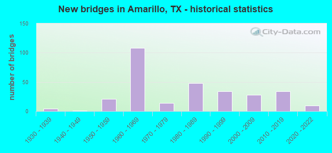
- New bridges - historical statistics
- 41930-1939
- 11940-1949
- 211950-1959
- 1081960-1969
- 141970-1979
- 481980-1989
- 341990-1999
- 282000-2009
- 342010-2019
- 102020-2022
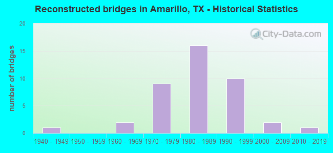
- Reconstructed bridges - Historical Statistics
- 11940-1949
- 01950-1959
- 21960-1969
- 91970-1979
- 161980-1989
- 101990-1999
- 22000-2009
- 12010-2019
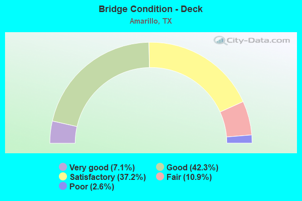
- Bridge Condition - Deck
- 7.1%Very good
- 42.3%Good
- 37.2%Satisfactory
- 10.9%Fair
- 2.6%Poor
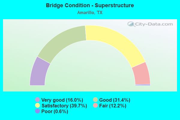
- Bridge Condition - Superstructure
- 16.0%Very good
- 31.4%Good
- 39.7%Satisfactory
- 12.2%Fair
- 0.6%Poor
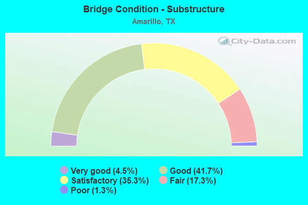
- Bridge Condition - Substructure
- 4.5%Very good
- 41.7%Good
- 35.3%Satisfactory
- 17.3%Fair
- 1.3%Poor
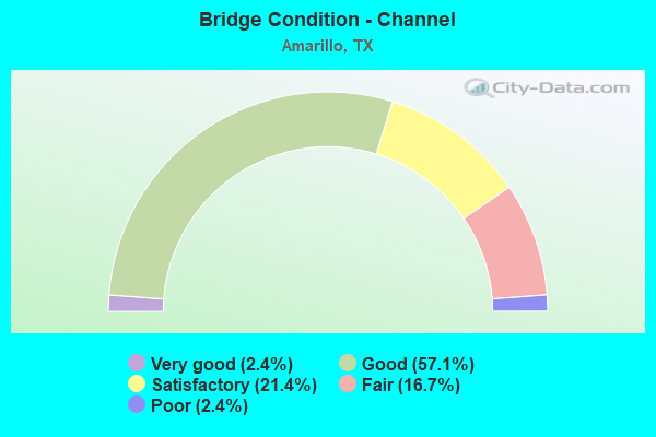
- Bridge Condition - Channel
- 2.4%Very good
- 57.1%Good
- 21.4%Satisfactory
- 16.7%Fair
- 2.4%Poor
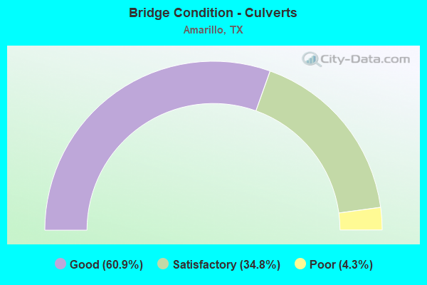
- Bridge Condition - Culverts
- 60.9%Good
- 34.8%Satisfactory
- 4.3%Poor
Find on map >> Show street view
Structure Number: 41880027501037, Location: I 40 MP 68.3 (Lat: 35.192700, Lng: -101.573569), Route carried "under" structure: County highway , Year Built: 1966, Structure Length: 0. m, Average Daily Traffic: 5,000 (year 2008), Truck Traffic: 30%, Features Intersected: Julian/Wolfin St, Facility Carried by Structure: IH 40 EB
Minimum Vertical Clearance: 4.80m (15.75ft), Kilometerpoint: 26.372, Lanes on structure: 3, Lanes under structure: 10, Material/Design: Prestressed concrete, Design/Construction: Stringer/Multi-beam, Length of Maximum Span: 30.5m (100.1ft)
Find on map >> Show street view
Structure Number: 4188002750104, Location: 1.65 MI W OF IH 27 (Lat: 35.195272, Lng: -101.866150), Route carried "under" structure: City street 11, Year Built: 1966, Structure Length: 0. m, Average Daily Traffic: 46,947 (year 2008), Features Intersected: Georgia Street, Facility Carried by Structure: IH 40 WB
Minimum Vertical Clearance: 4.83m (15.85ft), Kilometerpoint: 3.497, Lanes on structure: 3, Lanes under structure: 8, Material/Design: Steel continuous, Design/Construction: Stringer/Multi-beam, Length of Maximum Span: 29.0m (95.1ft)
Find on map >> Show street view
Structure Number: 41880027501041, Location: 1.65 MI W OF IH 27 (Lat: 35.195083, Lng: -101.866231), Route carried "under" structure: City street , Year Built: 1966, Structure Length: 0. m, Average Daily Traffic: 46,947 (year 2008), Features Intersected: Georgia Street, Facility Carried by Structure: IH 40 EB
Minimum Vertical Clearance: 5.41m (17.75ft), Kilometerpoint: 3.479, Lanes on structure: 3, Lanes under structure: 8, Material/Design: Steel continuous, Design/Construction: Stringer/Multi-beam, Length of Maximum Span: 29.0m (95.1ft)
Find on map >> Show street view
Structure Number: 41880027501042, Location: 3.3 MI E OF IH 27 (Lat: 35.192625, Lng: -101.778789), Route carried "under" structure: City street , Year Built: 1966, Structure Length: 0. m, Average Daily Traffic: 1,000 (year 2009), Truck Traffic: 3%, Features Intersected: Eastern St, Facility Carried by Structure: IH 40 WB
Minimum Vertical Clearance: 4.52m (14.83ft), Kilometerpoint: 35.367, Lanes on structure: 3, Lanes under structure: 4, Material/Design: Steel continuous, Design/Construction: Stringer/Multi-beam, Length of Maximum Span: 18.9m (62.0ft)
Find on map >> Show street view
Structure Number: 41880027501043, Location: 3.3 MI E OF IH 27 (Lat: 31.192447, Lng: -101.778775), Route carried "under" structure: City street , Year Built: 1966, Structure Length: 0. m, Average Daily Traffic: 1,000 (year 2009), Truck Traffic: 3%, Features Intersected: Eastern St, Facility Carried by Structure: IH 40 EB
Minimum Vertical Clearance: 4.67m (15.32ft), Kilometerpoint: 35.354, Lanes on structure: 3, Lanes under structure: 4, Material/Design: Steel continuous, Design/Construction: Stringer/Multi-beam, Length of Maximum Span: 18.9m (62.0ft)
Find on map >> Show street view
Structure Number: 41880027501076, Location: 1.0 Mi E of LP 335 W (Lat: 35.186547, Lng: -101.920272), Route carried "under" structure: City street , Year Built: 1969, Structure Length: 0. m, Average Daily Traffic: 3,000 (year 2008), Truck Traffic: 30%, Features Intersected: Coulter Street, Facility Carried by Structure: IH 40 EB
Minimum Vertical Clearance: 4.75m (15.58ft), Kilometerpoint: 22.056, Lanes on structure: 3, Lanes under structure: 8, Material/Design: Prestressed concrete, Design/Construction: Stringer/Multi-beam, Length of Maximum Span: 23.8m (78.1ft)
Find on map >> Show street view
Structure Number: 41880027501077, Location: 1.0 Mi E of LP 335 W (Lat: 35.186703, Lng: -101.920272), Route carried "under" structure: City street , Year Built: 1969, Structure Length: 0. m, Average Daily Traffic: 3,000 (year 2008), Truck Traffic: 30%, Features Intersected: Coulter Street, Facility Carried by Structure: IH 40 WB
Minimum Vertical Clearance: 4.85m (15.91ft), Kilometerpoint: 22.059, Lanes on structure: 3, Lanes under structure: 8, Material/Design: Prestressed concrete, Design/Construction: Stringer/Multi-beam, Length of Maximum Span: 23.8m (78.1ft)
Find on map >> Show street view
Structure Number: 41880027501079, Location: 8.2 MI E OF IH 27 (Lat: 35.193922, Lng: -101.692689), Route carried "under" structure: US 287, Year Built: 1968, Structure Length: 0. m, Average Daily Traffic: 6,030 (year 2013), Truck Traffic: 31%, Features Intersected: US 287 WB & BNSF RR, Facility Carried by Structure: IH 40 EB
Minimum Vertical Clearance: 7.57m (24.84ft), Kilometerpoint: 13.137, Lanes on structure: 2, Lanes under structure: 3, Material/Design: Steel continuous, Design/Construction: Stringer/Multi-beam, Length of Maximum Span: 28.7m (94.2ft)
Find on map >> Show street view
Structure Number: 4188002750108, Location: 8.2 MI E OF IH 27 (Lat: 35.194056, Lng: -101.692847), Route carried "under" structure: US 287, Year Built: 1968, Structure Length: 0. m, Average Daily Traffic: 6,030 (year 2013), Truck Traffic: 31%, Features Intersected: US 287 WB & BNSF RR, Facility Carried by Structure: IH 40 WB
Minimum Vertical Clearance: 7.67m (25.16ft), Kilometerpoint: 13.164, Lanes on structure: 2, Lanes under structure: 3, Material/Design: Steel continuous, Design/Construction: Stringer/Multi-beam, Length of Maximum Span: 29.9m (98.1ft)
Find on map >> Show street view
Structure Number: 41880027501081, Location: 1.4 MI E OF US 287 (Lat: 35.204931, Lng: -101.671725), Route carried "under" structure: Spur State highway 228, Year Built: 1968, Structure Length: 0. m, Average Daily Traffic: 200 (year 2013), Truck Traffic: 10%, Features Intersected: SP 228, Facility Carried by Structure: IH 40 EB
Minimum Vertical Clearance: 5.03m (16.50ft), Kilometerpoint: 0.282, Lanes on structure: 2, Lanes under structure: 2, Material/Design: Prestressed concrete, Design/Construction: Stringer/Multi-beam, Length of Maximum Span: 20.1m (65.9ft)
Find on map >> Show street view
Structure Number: 41880027501082, Location: 1.4 MI E OF US 287 (Lat: 35.205114, Lng: -101.671722), Route carried "under" structure: Spur State highway 228, Year Built: 1968, Structure Length: 0. m, Average Daily Traffic: 3,590 (year 2013), Truck Traffic: 4%, Features Intersected: SP 228, Facility Carried by Structure: IH 40 WB
Minimum Vertical Clearance: 5.03m (16.50ft), Kilometerpoint: 0.261, Lanes on structure: 2, Lanes under structure: 2, Material/Design: Prestressed concrete, Design/Construction: Stringer/Multi-beam, Length of Maximum Span: 20.1m (65.9ft)
Find on map >> Show street view
Structure Number: 41880027501083, Location: 2.5 MI E OF US 287 (Lat: 35.206903, Lng: -101.653744), Route carried "under" structure: State highway 1912, Year Built: 1968, Structure Length: 0. m, Average Daily Traffic: 4,600 (year 2009), Truck Traffic: 5%, Features Intersected: FM 1912, Facility Carried by Structure: IH 40 EB
Minimum Vertical Clearance: 4.78m (15.68ft), Kilometerpoint: 6.571, Lanes on structure: 2, Lanes under structure: 2, Material/Design: Prestressed concrete, Design/Construction: Stringer/Multi-beam, Length of Maximum Span: 18.9m (62.0ft)
Find on map >> Show street view
Structure Number: 41880027501084, Location: 2.5 MI E OF US 287 (Lat: 35.207083, Lng: -101.653744), Route carried "under" structure: State highway 1912, Year Built: 1968, Structure Length: 0. m, Average Daily Traffic: 4,600 (year 2009), Truck Traffic: 5%, Features Intersected: FM 1912, Facility Carried by Structure: IH 40 WB
Minimum Vertical Clearance: 4.78m (15.68ft), Kilometerpoint: 6.579, Lanes on structure: 2, Lanes under structure: 2, Material/Design: Prestressed concrete, Design/Construction: Stringer/Multi-beam, Length of Maximum Span: 18.9m (62.0ft)
Find on map >> Show street view
Structure Number: 41880027501102, Location: 0.2 MI W OF IH 27 (Lat: 35.193786, Lng: -101.842794), Route carried "under" structure: City street , Year Built: 2002, Structure Length: 0. m, Average Daily Traffic: 3,000 (year 2008), Truck Traffic: 30%, Features Intersected: Tyler & Harrison Street, Facility Carried by Structure: IH 40
Minimum Vertical Clearance: 5.16m (16.93ft), Kilometerpoint: 29.353, Lanes on structure: 9, Lanes under structure: 8, Material/Design: Prestressed concrete, Design/Construction: Stringer/Multi-beam, Length of Maximum Span: 19.5m (64.0ft)
Find on map >> Show street view
Structure Number: 41880027501104, Location: IH 40 MP 72.8 (Lat: 35.193281, Lng: -101.795175), Route carried "under" structure: Interstate 40, Year Built: 2000, Structure Length: 0. m, Average Daily Traffic: 60,640 (year 2013), Truck Traffic: 11%, Features Intersected: IH 40, Facility Carried by Structure: Grand St East T/A
Minimum Vertical Clearance: 5.31m (17.42ft), Kilometerpoint: 33.700, Material/Design: Prestressed concrete, Design/Construction: Stringer/Multi-beam, Length of Maximum Span: 18.3m (60.0ft)
Find on map >> Show street view
Structure Number: 41880027501105, Location: IH 40 at MP 72.8 (Lat: 35.192878, Lng: -101.795647), Route carried "under" structure: Interstate 40, Year Built: 2000, Structure Length: 0. m, Average Daily Traffic: 60,640 (year 2013), Truck Traffic: 11%, Features Intersected: IH 40, Facility Carried by Structure: Grand St West T/A
Minimum Vertical Clearance: 5.31m (17.42ft), Kilometerpoint: 33.671, Material/Design: Prestressed concrete, Design/Construction: Stringer/Multi-beam, Length of Maximum Span: 18.3m (60.0ft)
Find on map >> Show street view
Structure Number: 41880027501128, Location: 1.7 MI W OF LP 335 W (Lat: 35.187153, Lng: -101.968175), Route carried "under" structure: State highway 40, Year Built: 1969, Structure Length: 0. m, Average Daily Traffic: 1,090 (year 2013), Truck Traffic: 30%, Features Intersected: BI 40 EB
Minimum Vertical Clearance: 5.54m (18.18ft), Kilometerpoint: 19.945, Lanes on structure: 2, Lanes under structure: 2, Material/Design: Prestressed concrete, Design/Construction: Stringer/Multi-beam, Length of Maximum Span: 24.4m (80.1ft)
Find on map >> Show street view
Structure Number: 4188002750113, Location: 1.7 MI W OF LP 335 (Lat: 35.187528, Lng: -101.967653), Route carried "under" structure: State highway 40, Year Built: 1969, Structure Length: 0. m, Average Daily Traffic: 1,090 (year 2013), Truck Traffic: 30%, Features Intersected: BI 40 EB
Minimum Vertical Clearance: 5.84m (19.16ft), Kilometerpoint: 19.978, Lanes on structure: 2, Lanes under structure: 2, Material/Design: Prestressed concrete, Design/Construction: Stringer/Multi-beam, Length of Maximum Span: 21.3m (69.9ft)
Find on map >> Show street view
Structure Number: 41880027501131, Location: 1.7 MI W OF LP 335 W (Lat: 35.188028, Lng: -101.967317), Route carried "under" structure: State highway 40, Year Built: 1969, Structure Length: 0. m, Average Daily Traffic: 1,090 (year 2013), Truck Traffic: 30%, Features Intersected: BI 40 EB
Minimum Vertical Clearance: 5.64m (18.50ft), Kilometerpoint: 20.043, Lanes on structure: 2, Lanes under structure: 2, Material/Design: Prestressed concrete, Design/Construction: Stringer/Multi-beam, Length of Maximum Span: 18.3m (60.0ft)
Find on map >> Show street view
Structure Number: 41880027501132, Location: IH 40 & IH 27 INTERCHANGE (Lat: 35.194392, Lng: -101.836431), Route carried "under" structure: Interstate 27, Year Built: 1965, Structure Length: 0. m, Average Daily Traffic: 48,260 (year 2011), Truck Traffic: 18%, Features Intersected: IH 27
Minimum Vertical Clearance: 5.72m (18.77ft), Kilometerpoint: 30.059, Lanes on structure: 1, Lanes under structure: 6, Material/Design: Steel continuous, Design/Construction: Stringer/Multi-beam, Length of Maximum Span: 22.9m (75.1ft)
Find on map >> Show street view
Structure Number: 41880027501137, Location: IH 40 & IH 27 INTERCHANGE (Lat: 35.194708, Lng: -101.836414), Route carried "under" structure: Interstate 27, Year Built: 1965, Structure Length: 0. m, Average Daily Traffic: 48,260 (year 2011), Truck Traffic: 18%, Features Intersected: IH 27
Minimum Vertical Clearance: 4.85m (15.91ft), Kilometerpoint: 30.059, Lanes on structure: 1, Lanes under structure: 6, Material/Design: Steel continuous, Design/Construction: Stringer/Multi-beam, Length of Maximum Span: 21.6m (70.9ft)
Find on map >> Show street view
Structure Number: 41880027501152, Location: IH40 MP 68.3 (Lat: 35.192889, Lng: -101.873531), Route carried "under" structure: County highway , Year Built: 1966, Structure Length: 0. m, Average Daily Traffic: 5,000 (year 2008), Truck Traffic: 30%, Features Intersected: Julian/Wolfin St, Facility Carried by Structure: IH 40 WB
Minimum Vertical Clearance: 4.67m (15.32ft), Kilometerpoint: 26.372, Lanes on structure: 3, Lanes under structure: 10, Material/Design: Prestressed concrete, Design/Construction: Stringer/Multi-beam, Length of Maximum Span: 30.5m (100.1ft)
Find on map >> Show street view
Structure Number: 41880027501158, Location: 1.8 MI W OF IH 27 (Lat: 35.195506, Lng: -101.868661), Route carried "under" structure: Ramp State highway 40, Year Built: 1998, Structure Length: 0. m, Average Daily Traffic: 6,000 (year 2008), Truck Traffic: 30%, Features Intersected: IH 40 WB On Ramp
Minimum Vertical Clearance: 5.03m (16.50ft), Kilometerpoint: 26.889, Lanes on structure: 1, Lanes under structure: 1, Material/Design: Prestressed concrete, Design/Construction: Stringer/Multi-beam, Length of Maximum Span: 21.0m (68.9ft)
Find on map >> Show street view
Structure Number: 41880027501159, Location: 1.80 MI W OF IH 27 (Lat: 35.194819, Lng: -101.868353), Route carried "under" structure: Ramp State highway 40, Year Built: 1998, Structure Length: 0. m, Average Daily Traffic: 6,000 (year 2008), Truck Traffic: 30%, Features Intersected: IH 40 EB On Ramp
Minimum Vertical Clearance: 4.98m (16.34ft), Kilometerpoint: 26.873, Lanes on structure: 1, Lanes under structure: 1, Material/Design: Prestressed concrete, Design/Construction: Stringer/Multi-beam, Length of Maximum Span: 18.0m (59.1ft)
Find on map >> Show street view
Structure Number: 4188002750116, Location: 2.05 MI E OF LP 335 (Lat: 35.190114, Lng: -101.902756), Route carried "under" structure: Interstate 40, Year Built: 2001, Structure Length: 0. m, Average Daily Traffic: 67,900 (year 2013), Truck Traffic: 10%, Features Intersected: BELL ST W TURNAROUND, Facility Carried by Structure: Bell St W T/A
Minimum Vertical Clearance: 5.26m (17.26ft), Kilometerpoint: 23.775, Lanes on structure: 1, Lanes under structure: 6, Material/Design: Prestressed concrete, Design/Construction: Stringer/Multi-beam, Length of Maximum Span: 19.8m (65.0ft)
Find on map >> Show street view
Structure Number: 41880027501162, Location: 0.7 MI W OF IH 27 (Lat: 35.194300, Lng: -101.848481), Route carried "under" structure: Interstate 40, Year Built: 2003, Structure Length: 0. m, Average Daily Traffic: 81,180 (year 2010), Truck Traffic: 15%, Features Intersected: WASHINGTON STREET, Facility Carried by Structure: WASHINGTON STREET
Minimum Vertical Clearance: 5.05m (16.57ft), Kilometerpoint: 28.979, Lanes on structure: 8, Lanes under structure: 6, Material/Design: Prestressed concrete, Design/Construction: Stringer/Multi-beam, Length of Maximum Span: 22.9m (75.1ft)
Find on map >> Show street view
Structure Number: 41880027501164, Location: 1.0 Mi E of LP 335 (Lat: 35.192564, Lng: -101.724369), Route carried "under" structure: Interstate 40, Year Built: 2003, Structure Length: 0. m, Average Daily Traffic: 46,570 (year 2010), Truck Traffic: 21%, Features Intersected: IH 40, Facility Carried by Structure: SP 468
Minimum Vertical Clearance: 5.56m (18.24ft), Kilometerpoint: 40.324, Material/Design: Prestressed concrete, Design/Construction: Box Beam or Girders - Multiple, Length of Maximum Span: 18.3m (60.0ft)
Find on map >> Show street view
Structure Number: 41880027501173, Location: 1.12 mi E of IH 27 (Lat: 35.192514, Lng: -101.818072), Route carried "under" structure: City street 40, Year Built: 2018, Structure Length: 0. m, Average Daily Traffic: 18,650 (year 2018), Features Intersected: IH 40
Minimum Vertical Clearance: 30+ m (98+ ft), Lanes on structure: 4, Lanes under structure: 7, Material/Design: Prestressed concrete, Design/Construction: Stringer/Multi-beam, Length of Maximum Span: 30.5m (100.1ft)
Find on map >> Show street view
Structure Number: 41880027501179, Location: 1.0 Mi E of Whitaker Rd (Lat: 35.192839, Lng: -101.742289), Route carried "under" structure: State highway 335, Year Built: 2020, Structure Length: 0. m, Average Daily Traffic: 19,758 (year 2019), Truck Traffic: 9%, Features Intersected: SLP 335, Facility Carried by Structure: IH 40 WB
Minimum Vertical Clearance: 5.21m (17.09ft), Kilometerpoint: 38.497, Lanes on structure: 3, Lanes under structure: 8, Material/Design: Prestressed concrete, Design/Construction: Stringer/Multi-beam, Length of Maximum Span: 36.3m (119.1ft)
Find on map >> Show street view
Structure Number: 41880027501181, Location: 1.0 MI W OF SLP 335 (Lat: 35.192675, Lng: -101.760075), Year Built: 2020, Structure Length: 0. m, Truck Traffic: 20%, Features Intersected: Whitaker
Minimum Vertical Clearance: 5.15m (16.90ft), Kilometerpoint: 36.883, Lanes on structure: 3, Lanes under structure: 4, Material/Design: Prestressed concrete, Design/Construction: Stringer/Multi-beam, Length of Maximum Span: 28.7m (94.2ft)
Find on map >> Show street view
Structure Number: 41880027501182, Location: 2 MI E OF LP 335 (Lat: 35.192758, Lng: -101.706767), Year Built: 2021, Structure Length: 0. m, Average Daily Traffic: 1,664 (year 2019), Truck Traffic: 5%, Features Intersected: I40 EB
Minimum Vertical Clearance: 5.30m (17.39ft), Kilometerpoint: 8.174, Lanes on structure: 2, Lanes under structure: 5, Material/Design: Prestressed concrete, Design/Construction: Stringer/Multi-beam, Length of Maximum Span: 29.6m (97.1ft)
Find on map >> Show street view
Structure Number: 41880027501183, Location: 2 MI E OF LP 335 (Lat: 35.192808, Lng: -101.706786), Route carried "under" structure: State highway 1258, Year Built: 2019, Structure Length: 0. m, Average Daily Traffic: 2,020 (year 2013), Truck Traffic: 5%, Features Intersected: FM 1258, Facility Carried by Structure: IH 40 WB
Minimum Vertical Clearance: 5.30m (17.39ft), Kilometerpoint: 8.103, Lanes on structure: 4, Lanes under structure: 2, Material/Design: Prestressed concrete, Design/Construction: Stringer/Multi-beam, Length of Maximum Span: 29.6m (97.1ft)
Find on map >> Show street view
Structure Number: 41880037903022, Location: 2.5 MI N OF IH 40 (Lat: 35.259947, Lng: -101.742894), Route carried "under" structure: State highway 136, Year Built: 1980, Structure Length: 0. m, Average Daily Traffic: 4,570 (year 2013), Truck Traffic: 9%, Features Intersected: SH 136, Facility Carried by Structure: LP 335 NB
Minimum Vertical Clearance: 5.44m (17.85ft), Kilometerpoint: 15.611, Lanes on structure: 2, Lanes under structure: 4, Material/Design: Prestressed concrete continuous, Design/Construction: Stringer/Multi-beam, Length of Maximum Span: 45.7m (149.9ft)
Find on map >> Show street view
Structure Number: 41880037903023, Location: 2.5 MI N OF IH 40 (Lat: 35.259897, Lng: -101.743128), Route carried "under" structure: State highway 136, Year Built: 1980, Structure Length: 0. m, Average Daily Traffic: 1,830 (year 2013), Truck Traffic: 8%, Features Intersected: SH 136, Facility Carried by Structure: LP 335 SB
Minimum Vertical Clearance: 5.56m (18.24ft), Kilometerpoint: 15.659, Lanes on structure: 2, Lanes under structure: 4, Material/Design: Prestressed concrete continuous, Design/Construction: Stringer/Multi-beam, Length of Maximum Span: 45.7m (149.9ft)
Find on map >> Show street view
Structure Number: 41880263501007, Location: 0.55 MI N OF IH 40 (Lat: 35.200628, Lng: -101.742433), Route carried "under" structure: State highway 335, Year Built: 1978, Structure Length: 0. m, Average Daily Traffic: 16,250 (year 2013), Truck Traffic: 5%, Features Intersected: Loop 335, Facility Carried by Structure: SE 3rd Ave
Minimum Vertical Clearance: 5.18m (16.99ft), Kilometerpoint: 35.389, Lanes on structure: 4, Lanes under structure: 6, Material/Design: Prestressed concrete, Design/Construction: Stringer/Multi-beam, Length of Maximum Span: 24.4m (80.1ft)
Find on map >> Show street view
Structure Number: 41880263501009, Location: 1.6 MI S OF SH 136 (Lat: 35.236428, Lng: -101.742131), Route carried "under" structure: City street , Year Built: 1980, Structure Length: 0. m, Average Daily Traffic: 500 (year 2017), Truck Traffic: 3%, Features Intersected: NE 24th Street, Facility Carried by Structure: LP 335
Minimum Vertical Clearance: 4.80m (15.75ft), Kilometerpoint: 31.379, Lanes on structure: 4, Lanes under structure: 2, Material/Design: Prestressed concrete, Design/Construction: Stringer/Multi-beam, Length of Maximum Span: 30.5m (100.1ft)
Find on map >> Show street view
Structure Number: 41880263501012, Location: 3.2 MI E OF US 287 (Lat: 35.265317, Lng: -101.777639), Route carried "under" structure: City street , Year Built: 1980, Structure Length: 0. m, Average Daily Traffic: 500 (year 2009), Truck Traffic: 3%, Features Intersected: Eastern Street, Facility Carried by Structure: LP 335 WB
Minimum Vertical Clearance: 5.28m (17.32ft), Kilometerpoint: 25.286, Lanes on structure: 2, Lanes under structure: 2, Material/Design: Prestressed concrete, Design/Construction: Stringer/Multi-beam, Length of Maximum Span: 30.5m (100.1ft)
Find on map >> Show street view
Structure Number: 41880263501013, Location: 3.2 MI E OF US 287 (Lat: 35.265125, Lng: -101.777642), Route carried "under" structure: City street , Year Built: 1980, Structure Length: 0. m, Average Daily Traffic: 500 (year 2009), Truck Traffic: 3%, Features Intersected: Eastern Street, Facility Carried by Structure: LP 335 EB
Minimum Vertical Clearance: 5.28m (17.32ft), Kilometerpoint: 25.286, Lanes on structure: 2, Lanes under structure: 2, Material/Design: Prestressed concrete, Design/Construction: Stringer/Multi-beam, Length of Maximum Span: 30.5m (100.1ft)
Find on map >> Show street view
Structure Number: 41880263504027, Location: 0.9 MI W OF US 87 (Lat: 35.265481, Lng: -101.848939), Route carried "under" structure: State highway 335, Year Built: 1995, Structure Length: 0. m, Average Daily Traffic: 6,900 (year 2012), Truck Traffic: 6%, Features Intersected: LP 335, Facility Carried by Structure: FM 2176
Minimum Vertical Clearance: 5.46m (17.91ft), Kilometerpoint: 9.577, Lanes on structure: 3, Lanes under structure: 4, Material/Design: Prestressed concrete, Design/Construction: Stringer/Multi-beam, Length of Maximum Span: 22.9m (75.1ft)
Find on map >> Show street view
Structure Number: 41880263504034, Location: 5.8 MI N OF IH 40 (Lat: 35.255678, Lng: -101.907269), Route carried "under" structure: City street , Year Built: 1998, Structure Length: 0. m, Average Daily Traffic: 75 (year 2012), Truck Traffic: 2%, Features Intersected: Hester Rd & BNSF RR, Facility Carried by Structure: LP 335
Minimum Vertical Clearance: 6.53m (21.42ft), Kilometerpoint: 0.000, Lanes on structure: 2, Lanes under structure: 4, Material/Design: Prestressed concrete, Design/Construction: Stringer/Multi-beam, Length of Maximum Span: 38.4m (126.0ft)
Find on map >> Show street view
Structure Number: 41880263504035, Location: 4.0 MI N OF IH 40 (Lat: 35.243858, Lng: -101.934814), Route carried "under" structure: State highway 1061, Year Built: 1999, Structure Length: 0. m, Average Daily Traffic: 2,430 (year 2012), Truck Traffic: 10%, Features Intersected: RM 1061, Facility Carried by Structure: LP 335
Minimum Vertical Clearance: 5.44m (17.85ft), Kilometerpoint: 43.066, Lanes on structure: 2, Lanes under structure: 3, Material/Design: Prestressed concrete, Design/Construction: Stringer/Multi-beam, Length of Maximum Span: 36.6m (120.1ft)
Find on map >> Show street view
Structure Number: 41880263504078, Location: 2.85 MI W OF US 87 (Lat: 35.262456, Lng: -101.884608), Route carried "under" structure: State highway 1719, Year Built: 1996, Structure Length: 0. m, Average Daily Traffic: 8,600 (year 2009), Features Intersected: FM 1719, Facility Carried by Structure: LP 335 WB
Minimum Vertical Clearance: 5.41m (17.75ft), Kilometerpoint: 13.737, Lanes on structure: 2, Lanes under structure: 4, Material/Design: Prestressed concrete, Design/Construction: Stringer/Multi-beam, Length of Maximum Span: 29.0m (95.1ft)
Find on map >> Show street view
Structure Number: 41880263504079, Location: 3. Mi W of US 87 (Lat: 35.262261, Lng: -101.885000), Route carried "under" structure: State highway 1719, Year Built: 2005, Structure Length: 0. m, Average Daily Traffic: 8,600 (year 2010), Truck Traffic: 6%, Features Intersected: FM 1719 ( Western St.), Facility Carried by Structure: LP 335 EB
Minimum Vertical Clearance: 5.13m (16.83ft), Kilometerpoint: 13.737, Lanes on structure: 2, Lanes under structure: 4, Material/Design: Prestressed concrete, Design/Construction: Stringer/Multi-beam, Length of Maximum Span: 29.9m (98.1ft)
Find on map >> Show street view
Structure Number: 41880325101001, Location: 0.35 Mi N of IH 40 (Lat: 35.198681, Lng: -101.724486), Route carried "under" structure: County highway , Year Built: 1971, Structure Length: 0. m, Average Daily Traffic: 2,000 (year 2008), Truck Traffic: 30%, Features Intersected: E 3rd Ave & BNSF RR, Facility Carried by Structure: SP 468 Airport Rd
Minimum Vertical Clearance: 7.67m (25.16ft), Kilometerpoint: 1.609, Lanes on structure: 6, Lanes under structure: 4, Material/Design: Prestressed concrete, Design/Construction: Stringer/Multi-beam, Length of Maximum Span: 25.9m (85.0ft)
Structure Number: 41880800504008, Location: 1.1 Mi N of IH 40, Route carried "under" structure: City street , Year Built: 2005, Structure Length: 0. m, Average Daily Traffic: 500 (year 2012), Truck Traffic: 2%, Features Intersected: BNSF RR & NE 3rd Ave, Facility Carried by Structure: Ross-Mirror St
Minimum Vertical Clearance: 5.69m (18.67ft), Kilometerpoint: 0.000, Material/Design: Prestressed concrete, Design/Construction: Stringer/Multi-beam, Length of Maximum Span: 40.8m (133.9ft)
Minimum Vertical Clearance: 5.69m (18.67ft), Kilometerpoint: 0.000, Material/Design: Prestressed concrete, Design/Construction: Stringer/Multi-beam, Length of Maximum Span: 40.8m (133.9ft)
Find on map >> Show street view
Structure Number: 41880801304007, Location: 1.4 Mi N of IH 40 (Lat: 35.216461, Lng: -101.848100), Route carried "under" structure: City street , Year Built: 1985, Structure Length: 0. m, Average Daily Traffic: 100 (year 2012), Truck Traffic: 3%, Features Intersected: NW 1st ave, Facility Carried by Structure: Hughes Adams St
Minimum Vertical Clearance: 6.38m (20.93ft), Lanes on structure: 4, Lanes under structure: 4, Material/Design: Prestressed concrete, Design/Construction: Stringer/Multi-beam, Length of Maximum Span: 24.1m (79.1ft)
Find on map >> Show street view
Structure Number: 41880801304007, Location: 1.4 Mi N of IH 40 (Lat: 35.216461, Lng: -101.848100), Route carried "under" structure: City street , Year Built: 1985, Structure Length: 0. m, Average Daily Traffic: 100 (year 2012), Truck Traffic: 1%, Features Intersected: SW 1st ave, Facility Carried by Structure: Hughes Adams St
Minimum Vertical Clearance: 6.38m (20.93ft), Kilometerpoint: 0.000, Lanes on structure: 4, Lanes under structure: 3, Material/Design: Prestressed concrete, Design/Construction: Stringer/Multi-beam, Length of Maximum Span: 24.1m (79.1ft)
Find on map >> Show street view
Structure Number: 41880B00604003, Location: 0.5 Mi N of IH 40 (Lat: 35.207369, Lng: -101.795000), Route carried "under" structure: City street 3, Year Built: 2012, Structure Length: 0. m, Average Daily Traffic: 6,000 (year 2011), Truck Traffic: 15%, Features Intersected: 3rd St & BNSF RR, Facility Carried by Structure: Grand St
Minimum Vertical Clearance: 6.25m (20.51ft), Lanes on structure: 4, Lanes under structure: 4, Material/Design: Prestressed concrete, Design/Construction: Stringer/Multi-beam, Length of Maximum Span: 42.7m (140.1ft)
Find on map >> Show street view
Structure Number: 41910016809027, Location: 0.4 Mi W of FM 1541 (Lat: 35.175358, Lng: -101.855081), Route carried "under" structure: City street , Year Built: 1958, Structure Length: 0. m, Average Daily Traffic: 500 (year 2012), Truck Traffic: 1%, Features Intersected: Parker St., Facility Carried by Structure: IH 27 NB
Minimum Vertical Clearance: 4.42m (14.50ft), Kilometerpoint: 0.000, Lanes on structure: 3, Lanes under structure: 4, Material/Design: Steel continuous, Design/Construction: Stringer/Multi-beam, Length of Maximum Span: 22.9m (75.1ft)
Find on map >> Show street view
Structure Number: 41910016809028, Location: 1.5 MI S OF IH 40 (Lat: 35.176456, Lng: -101.848475), Route carried "under" structure: State highway 1541, Year Built: 1958, Structure Length: 0. m, Average Daily Traffic: 17,100 (year 2013), Truck Traffic: 4%, Features Intersected: FM 1541 (Washington Ave), Facility Carried by Structure: IH 27 NB
Minimum Vertical Clearance: 4.42m (14.50ft), Kilometerpoint: 1.651, Lanes on structure: 3, Lanes under structure: 7, Material/Design: Steel continuous, Design/Construction: Stringer/Multi-beam, Length of Maximum Span: 21.3m (69.9ft)
Find on map >> Show street view
Structure Number: 41910016809039, Location: 1.7 Mi SW of FM 1541 (Lat: 35.163778, Lng: -101.871844), Route carried "under" structure: City street , Year Built: 1961, Structure Length: 0. m, Average Daily Traffic: 750 (year 2012), Truck Traffic: 1%, Features Intersected: 45th Ave, Facility Carried by Structure: IH 27 NB
Minimum Vertical Clearance: 5.26m (17.26ft), Kilometerpoint: 0.000, Lanes on structure: 3, Lanes under structure: 6, Material/Design: Steel continuous, Design/Construction: Stringer/Multi-beam, Length of Maximum Span: 23.8m (78.1ft)
Find on map >> Show street view
Structure Number: 4191001680904, Location: 1.1 Mi SW of FM 1541 (Lat: 35.169953, Lng: -101.865981), Route carried "under" structure: City street 21, Year Built: 1961, Structure Length: 0. m, Average Daily Traffic: 23,380 (year 2012), Features Intersected: Georgia St., Facility Carried by Structure: IH 27 NB
Minimum Vertical Clearance: 5.33m (17.49ft), Kilometerpoint: 0.684, Lanes on structure: 3, Lanes under structure: 6, Material/Design: Steel continuous, Design/Construction: Stringer/Multi-beam, Length of Maximum Span: 18.3m (60.0ft)
Find on map >> Show street view
Structure Number: 41910016809041, Location: 2.7 Mi NE of LP 335S (Lat: 35.149983, Lng: -101.883783), Route carried "under" structure: City street 19, Year Built: 1961, Structure Length: 0. m, Average Daily Traffic: 18,285 (year 2012), Features Intersected: Western Ave, Facility Carried by Structure: IH 27 SB
Minimum Vertical Clearance: 4.83m (15.85ft), Kilometerpoint: 5.259, Lanes on structure: 3, Lanes under structure: 6, Material/Design: Steel continuous, Design/Construction: Stringer/Multi-beam, Length of Maximum Span: 21.3m (69.9ft)
Find on map >> Show street view
Structure Number: 41910016809042, Location: 2.7 Mi NE of LP 335S (Lat: 35.149900, Lng: -101.883844), Route carried "under" structure: City street 19, Year Built: 1961, Structure Length: 0. m, Average Daily Traffic: 18,285 (year 2012), Features Intersected: Western Ave., Facility Carried by Structure: IH 27 NB
Minimum Vertical Clearance: 4.83m (15.85ft), Kilometerpoint: 5.230, Lanes on structure: 3, Lanes under structure: 6, Material/Design: Steel continuous, Design/Construction: Stringer/Multi-beam, Length of Maximum Span: 21.3m (69.9ft)
Find on map >> Show street view
Structure Number: 41910016809051, Location: 0.9 Mi NE of SH 335 (Lat: 35.129058, Lng: -101.901667), Route carried "under" structure: City street , Year Built: 1983, Structure Length: 0. m, Average Daily Traffic: 15,000 (year 2012), Features Intersected: Bell Ave, Facility Carried by Structure: IH 27 SB
Minimum Vertical Clearance: 5.18m (16.99ft), Kilometerpoint: 0.805, Lanes on structure: 2, Lanes under structure: 4, Material/Design: Prestressed concrete, Design/Construction: Stringer/Multi-beam, Length of Maximum Span: 38.1m (125.0ft)
Find on map >> Show street view
Structure Number: 41910016809052, Location: 0.9 Mi NE of SH 355 (Lat: 35.129164, Lng: -101.901858), Route carried "under" structure: City street , Year Built: 1983, Structure Length: 0. m, Average Daily Traffic: 15,000 (year 2012), Truck Traffic: 1%, Features Intersected: Bell Ave., Facility Carried by Structure: IH 27 NB
Minimum Vertical Clearance: 5.84m (19.16ft), Kilometerpoint: 0.000, Lanes on structure: 2, Lanes under structure: 4, Material/Design: Prestressed concrete, Design/Construction: Stringer/Multi-beam, Length of Maximum Span: 38.1m (125.0ft)
Find on map >> Show street view
Structure Number: 41910016809053, Location: 1.7 Mi SW of FM 1541 (Lat: 35.163719, Lng: -101.871914), Route carried "under" structure: City street , Year Built: 1961, Structure Length: 0. m, Average Daily Traffic: 34,940 (year 2012), Features Intersected: 45th St, Facility Carried by Structure: IH 27 SB
Minimum Vertical Clearance: 4.72m (15.49ft), Kilometerpoint: 0.805, Lanes on structure: 3, Lanes under structure: 6, Material/Design: Steel continuous, Design/Construction: Stringer/Multi-beam, Length of Maximum Span: 23.8m (78.1ft)
Find on map >> Show street view
Structure Number: 41910016809054, Location: 2.4 Mi NE of LP 335S (Lat: 35.146392, Lng: -101.887375), Route carried "under" structure: City street , Year Built: 1985, Structure Length: 0. m, Average Daily Traffic: 15,345 (year 2012), Features Intersected: Hillside Rd, Facility Carried by Structure: IH 27 SBFR
Minimum Vertical Clearance: 5.05m (16.57ft), Kilometerpoint: 2.977, Lanes on structure: 2, Lanes under structure: 4, Material/Design: Prestressed concrete, Design/Construction: Stringer/Multi-beam, Length of Maximum Span: 24.4m (80.1ft)
Find on map >> Show street view
Structure Number: 41910016809055, Location: 2.4 Mi NE of LP 335S (Lat: 35.146572, Lng: -101.886850), Route carried "under" structure: City street , Year Built: 1985, Structure Length: 0. m, Average Daily Traffic: 15,345 (year 2012), Features Intersected: Hillside Rd, Facility Carried by Structure: IH 27 SBML
Minimum Vertical Clearance: 5.66m (18.57ft), Kilometerpoint: 2.977, Lanes on structure: 2, Lanes under structure: 4, Material/Design: Prestressed concrete, Design/Construction: Stringer/Multi-beam, Length of Maximum Span: 24.4m (80.1ft)
Find on map >> Show street view
Structure Number: 41910016809056, Location: 2.4 Mi NE of LP 335S (Lat: 35.146467, Lng: -101.886667), Route carried "under" structure: City street , Year Built: 1985, Structure Length: 0. m, Average Daily Traffic: 15,345 (year 2012), Features Intersected: Hillside Rd, Facility Carried by Structure: IH 27 NBML
Minimum Vertical Clearance: 6.61m (21.69ft), Kilometerpoint: 2.977, Lanes on structure: 2, Lanes under structure: 4, Material/Design: Prestressed concrete, Design/Construction: Stringer/Multi-beam, Length of Maximum Span: 24.1m (79.1ft)
Find on map >> Show street view
Structure Number: 41910016809057, Location: 2.4 Mi NE of LP 335S (Lat: 35.146386, Lng: -101.886353), Route carried "under" structure: City street , Year Built: 1985, Structure Length: 0. m, Average Daily Traffic: 15,345 (year 2012), Features Intersected: Hillside Rd., Facility Carried by Structure: IH 27 NBFR
Minimum Vertical Clearance: 5.05m (16.57ft), Kilometerpoint: 2.977, Lanes on structure: 2, Lanes under structure: 4, Material/Design: Prestressed concrete, Design/Construction: Stringer/Multi-beam, Length of Maximum Span: 24.1m (79.1ft)
Find on map >> Show street view
Structure Number: 41910016809061, Location: 1.0 MI S OF LP 335 (Lat: 35.102139, Lng: -101.912953), Route carried "under" structure: Interstate 27, Year Built: 1986, Structure Length: 0. m, Average Daily Traffic: 36,690 (year 2013), Truck Traffic: 12%, Features Intersected: IH 27, Facility Carried by Structure: CR163 (Sundown Ln)
Minimum Vertical Clearance: 5.56m (18.24ft), Kilometerpoint: 12.229, Lanes on structure: 2, Lanes under structure: 8, Material/Design: Prestressed concrete, Design/Construction: Stringer/Multi-beam, Length of Maximum Span: 24.4m (80.1ft)
Find on map >> Show street view
Structure Number: 41910016809062, Location: 0.5 Mi E of FM 1541 (Lat: 35.178300, Lng: -101.841281), Route carried "under" structure: Interstate 27, Year Built: 1989, Structure Length: 0. m, Average Daily Traffic: 57,960 (year 2013), Truck Traffic: 10%, Features Intersected: IH 27, Facility Carried by Structure: SW 34th St
Minimum Vertical Clearance: 5.13m (16.83ft), Kilometerpoint: 23.529, Lanes on structure: 4, Lanes under structure: 6, Material/Design: Prestressed concrete, Design/Construction: Box Beam or Girders - Multiple, Length of Maximum Span: 28.7m (94.2ft)
Find on map >> Show street view
Structure Number: 41910016809063, Location: 0.4 Mi E of FM 1541 (Lat: 35.177339, Lng: -101.842233), Route carried "under" structure: Interstate 27, Year Built: 1989, Structure Length: 0. m, Average Daily Traffic: 57,960 (year 2013), Truck Traffic: 10%, Features Intersected: IH 27, Facility Carried by Structure: Tyler St
Minimum Vertical Clearance: 5.03m (16.50ft), Kilometerpoint: 23.397, Lanes on structure: 3, Lanes under structure: 6, Material/Design: Prestressed concrete, Design/Construction: Box Beam or Girders - Multiple, Length of Maximum Span: 28.7m (94.2ft)
Find on map >> Show street view
Structure Number: 41910016809068, Location: 1.1 Mi SW of FM 1541 (Lat: 35.170011, Lng: -101.866228), Route carried "under" structure: City street , Year Built: 1961, Structure Length: 0. m, Average Daily Traffic: 20,920 (year 2012), Features Intersected: Georgia St, Facility Carried by Structure: IH 27 SB
Minimum Vertical Clearance: 5.18m (16.99ft), Kilometerpoint: 0.684, Lanes on structure: 3, Lanes under structure: 6, Material/Design: Steel continuous, Design/Construction: Stringer/Multi-beam, Length of Maximum Span: 18.3m (60.0ft)
Find on map >> Show street view
Structure Number: 41910016809069, Location: 0.4 Mi W of FM 1541 (Lat: 35.175508, Lng: -101.855208), Route carried "under" structure: City street , Year Built: 1958, Structure Length: 0. m, Average Daily Traffic: 500 (year 2012), Truck Traffic: 1%, Features Intersected: Parker St., Facility Carried by Structure: IH 27 SB
Minimum Vertical Clearance: 4.47m (14.67ft), Kilometerpoint: 0.000, Lanes on structure: 3, Lanes under structure: 4, Material/Design: Steel continuous, Design/Construction: Stringer/Multi-beam, Length of Maximum Span: 22.9m (75.1ft)
Find on map >> Show street view
Structure Number: 4191001680907, Location: 1.5 Mi S of IH 40 (Lat: 35.176636, Lng: -101.848478), Route carried "under" structure: State highway 1541, Year Built: 1958, Structure Length: 0. m, Average Daily Traffic: 17,100 (year 2013), Truck Traffic: 4%, Features Intersected: FM 1541 (Washington St), Facility Carried by Structure: IH 27 SB
Minimum Vertical Clearance: 4.40m (14.44ft), Kilometerpoint: 1.638, Lanes on structure: 3, Lanes under structure: 7, Material/Design: Steel continuous, Design/Construction: Stringer/Multi-beam, Length of Maximum Span: 21.3m (69.9ft)
Structure Number: 41910016809171, Location: 0.4 Mi W of Bell St, Route carried "under" structure: State highway 335, Year Built: 2021, Structure Length: 0. m, Average Daily Traffic: 15,742 (year 2019), Features Intersected: IH 27 NB, Facility Carried by Structure: IH 27 NB
Minimum Vertical Clearance: 5.03m (16.50ft), Kilometerpoint: 634.082, Lanes on structure: 3, Lanes under structure: 7, Material/Design: Prestressed concrete, Design/Construction: Stringer/Multi-beam, Length of Maximum Span: 25.3m (83.0ft)
Minimum Vertical Clearance: 5.03m (16.50ft), Kilometerpoint: 634.082, Lanes on structure: 3, Lanes under structure: 7, Material/Design: Prestressed concrete, Design/Construction: Stringer/Multi-beam, Length of Maximum Span: 25.3m (83.0ft)
Find on map >> Show street view
Structure Number: 41910263502024, Location: 3.5 Mi E of IH 27 (Lat: 35.120372, Lng: -101.848292), Route carried "under" structure: State highway 1541, Year Built: 1989, Structure Length: 0. m, Average Daily Traffic: 6,980 (year 2013), Truck Traffic: 4%, Features Intersected: FM 1541 (Washington St), Facility Carried by Structure: LP 335
Minimum Vertical Clearance: 5.11m (16.77ft), Kilometerpoint: 7.929, Lanes on structure: 2, Lanes under structure: 4, Material/Design: Prestressed concrete, Design/Construction: Stringer/Multi-beam, Length of Maximum Span: 27.4m (89.9ft)
Find on map >> Show street view
Structure Number: 41910263502025, Location: 2.0 Mi E of FM 1541 (Lat: 35.120447, Lng: -101.813039), Route carried "under" structure: City street , Year Built: 1989, Structure Length: 0. m, Average Daily Traffic: 1,000 (year 2012), Truck Traffic: 2%, Features Intersected: Osage St, Facility Carried by Structure: LP 335
Minimum Vertical Clearance: 5.08m (16.67ft), Kilometerpoint: 1.609, Lanes on structure: 2, Lanes under structure: 3, Material/Design: Prestressed concrete, Design/Construction: Stringer/Multi-beam, Length of Maximum Span: 27.4m (89.9ft)
Find on map >> Show street view
Structure Number: 41910263502084, Location: 2.5 MI E of IH 27 (Lat: 35.120178, Lng: -101.866017), Route carried "under" structure: City street , Year Built: 2017, Structure Length: 0. m, Average Daily Traffic: 3,500 (year 2017), Truck Traffic: 5%, Features Intersected: Georgia St, Facility Carried by Structure: SLP 335
Minimum Vertical Clearance: 5.24m (17.19ft), Kilometerpoint: 1.609, Lanes on structure: 4, Lanes under structure: 5, Material/Design: Prestressed concrete, Design/Construction: Stringer/Multi-beam, Length of Maximum Span: 29.0m (95.1ft)
Find on map >> Show street view
Structure Number: 41910263502085, Location: 1.4 MI E of IH 27 (Lat: 35.117208, Lng: -101.883717), Route carried "under" structure: City street , Year Built: 2017, Structure Length: 0. m, Average Daily Traffic: 3,000 (year 2017), Truck Traffic: 5%, Features Intersected: Western St, Facility Carried by Structure: SLP 335
Minimum Vertical Clearance: 5.15m (16.90ft), Kilometerpoint: 1.624, Lanes on structure: 4, Lanes under structure: 6, Material/Design: Prestressed concrete, Design/Construction: Stringer/Multi-beam, Length of Maximum Span: 29.0m (95.1ft)
Find on map >> Show street view
Structure Number: 4191080170402, Location: 0.13 MI E OF IH 27 (Lat: 35.178411, Lng: -101.838542), Route carried "under" structure: City street , Year Built: 1983, Structure Length: 0. m, Average Daily Traffic: 500 (year 2012), Truck Traffic: 2%, Features Intersected: BNSF Airpark Dr Fillmore, Facility Carried by Structure: 34th Ave
Minimum Vertical Clearance: 5.51m (18.08ft), Kilometerpoint: 0.000, Lanes on structure: 4, Lanes under structure: 3, Material/Design: Prestressed concrete, Design/Construction: Stringer/Multi-beam, Length of Maximum Span: 39.3m (128.9ft)