Bridge Statistics for Amherst, New York (NY)
Condition, Traffic, Stress, Structural Evaluation, Project Costs
- National Bridge Inventory (NBI) Statistics
- 139Number of bridges
- 1,385ft / 422mTotal length
- $423,836,000Total costs
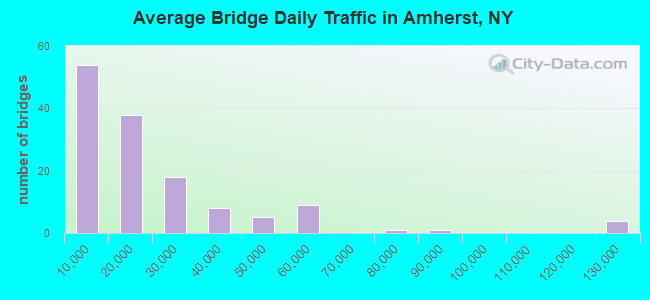
- 2,821,263Total average daily traffic
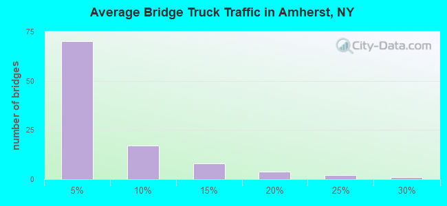
- 109,105Total average daily truck traffic
- National Bridge Inventory (NBI) Registered Bridges for Amherst
- No street view available for this location
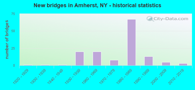
- New bridges - historical statistics
- 11920-1929
- 11930-1939
- 11940-1949
- 201950-1959
- 201960-1969
- 81970-1979
- 671980-1989
- 131990-1999
- 52000-2009
- 32010-2019
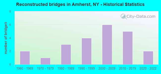
- Reconstructed bridges - Historical Statistics
- 21960-1969
- 11970-1979
- 31980-1989
- 41990-1999
- 62000-2009
- 52010-2019
- 22020-2022
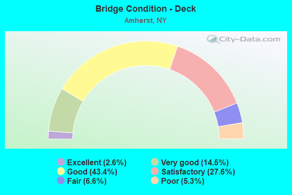
- Bridge Condition - Deck
- 2.6%Excellent
- 14.5%Very good
- 43.4%Good
- 27.6%Satisfactory
- 6.6%Fair
- 5.3%Poor
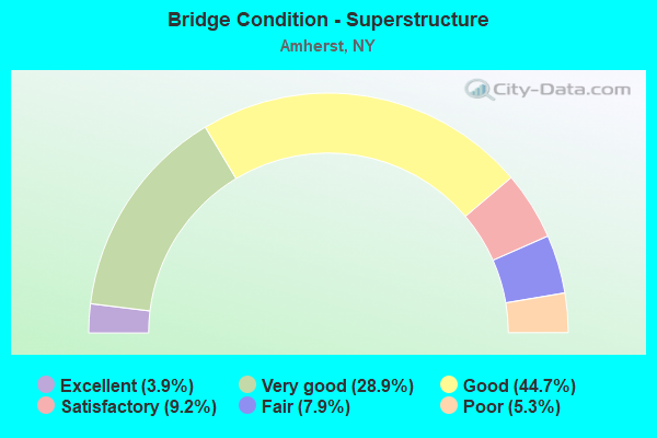
- Bridge Condition - Superstructure
- 3.9%Excellent
- 28.9%Very good
- 44.7%Good
- 9.2%Satisfactory
- 7.9%Fair
- 5.3%Poor
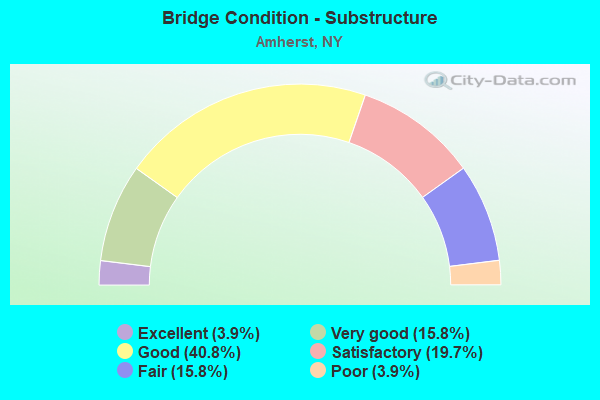
- Bridge Condition - Substructure
- 3.9%Excellent
- 15.8%Very good
- 40.8%Good
- 19.7%Satisfactory
- 15.8%Fair
- 3.9%Poor
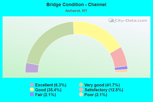
- Bridge Condition - Channel
- 6.3%Excellent
- 41.7%Very good
- 35.4%Good
- 12.5%Satisfactory
- 2.1%Fair
- 2.1%Poor
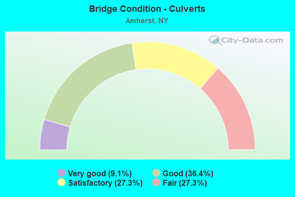
- Bridge Condition - Culverts
- 9.1%Very good
- 36.4%Good
- 27.3%Satisfactory
- 27.3%Fair
Find on map >> Show street view
Structure Number: 445301, Location: 1.5 MI W JCT 270+ BARGE C (Lat: 43.065994, Lng: -78.797525), Route carried "on" structure: County highway , Year Built: 1952, Year Reconstructed: 2003, Status: Open, Structure Length: 10.98m (36.02ft), Average Daily Traffic: 4,521 (year 2019), Truck Traffic: 3%, Average Future Daily Traffic: 6,329 (year 2039), Design Load: HS 20, Features Intersected: TONAWANDA CK ROAD, ERIE, Facility Carried by Structure: BEAR RIDGE ROAD
Minimum Vertical Clearance: 30+ m (98+ ft), Kilometerpoint: 0.225, Lanes on structure: 2, Lanes under structure: 2, Owner: State Highway Agency, Approaching Roadway Width: 9.4m (30.8ft), Navigation Control: Yes ( Vertical Clearance: 6.0m (19.7ft), Horizontal Clearance: 22.8m (74.8ft)), Material/Design: Steel, Design/Construction: Stringer/Multi-beam, Number Of Spans In Main Unit: 3, Length of Maximum Span: 50.6m (166.0ft), Curb-To-Curb Width: 9.1m (29.9ft), Out-to-Out Width: 10.1m (33.1ft)
Condition: Deck: Good, Superstructure: Good, Substructure: Good, Channel: Good, Operating Rating: 41.7 metric tons, Method Used To Determine Operating Rating: Load Factor (LF), Inventory Rating: 24.5 metric tons, Method Used To Determine Inventory Rating: Load Factor (LF), Structural Evaluation: Equal to present minimum criteria, Deck Geometry: Meets minimum limits, Underclear: Meets minimum limits, Waterway Adequacy: Better than present minimum criteria, Approach Roadway Alignment: Somewhat better than minimum adequacy, Length Of Structure Improvement: 10.98m (36.02ft), Designated Inspection Frequency: Every 24 months, Critical Feature Inspection Frequency: Every 24 months, Inspection Date: August 2020, Critical Feature Inspection Date: August 2020, Bridge Improvement Cost: $3,791,000, Roadway Improvement Cost: $2,220,000, Total Project Cost: $6,012,000 ( Estimate for 2021), Deck Structure Type: Concrete Cast-file-Place, Wearing Surface/Protective System: Wearing Surface: Monolithic Concrete, Deck Protection: Epoxy Coated Reinforcing
Find on map >> Show street view
Structure Number: 551177, Location: 3.1 MI W JCTOF RTS270<263 (Lat: 43.011725, Lng: -78.790992), Route carried "on" structure: State lands road , Year Built: 1976, Status: Open, Structure Length: 2.83m (9.28ft), Average Daily Traffic: 3,445 (year 2017), Truck Traffic: 4%, Average Future Daily Traffic: 4,823 (year 2037), Design Load: HS 20+Mod, Features Intersected: BIZER CREEK, Facility Carried by Structure: SKINNERSVILLE RD
Minimum Vertical Clearance: 30+ m (98+ ft), Kilometerpoint: 0.225, Lanes on structure: 2, Owner: State Agenciy, Approaching Roadway Width: 7.9m (25.9ft), Material/Design: Concrete continuous, Design/Construction: Frame, Number Of Spans In Main Unit: 3, Length of Maximum Span: 11.2m (36.7ft), Curb or Sidewalk Widths: Left: 2.7m (8.9ft), Right: 0.6m (2.0ft), Curb-To-Curb Width: 9.1m (29.9ft), Out-to-Out Width: 13.0m (42.7ft)
Condition: Deck: Satisfactory, Superstructure: Satisfactory, Substructure: Good, Channel: Very good, Operating Rating: 41.7 metric tons, Method Used To Determine Operating Rating: Load Factor (LF), Inventory Rating: 8.2 metric tons, Method Used To Determine Inventory Rating: Load Factor (LF), Structural Evaluation: High priority of corrective action, Deck Geometry: Meets minimum limits, Waterway Adequacy: Meets minimum limits, Approach Roadway Alignment: Equal to present desirable criteria, Length Of Structure Improvement: 2.83m (9.28ft), Designated Inspection Frequency: Every 24 months, Inspection Date: May 2020, Bridge Improvement Cost: $1,650,000, Roadway Improvement Cost: $966,000, Total Project Cost: $2,616,000 ( Estimate for 2021), Wearing Surface/Protective System: Wearing Surface: Bituminous
Find on map >> Show street view
Structure Number: 5511791, Location: 2.7 MI SW JCT SH270&SH263 (Lat: 43.006358, Lng: -78.783294), Route carried "on" structure: State lands road , Year Built: 1976, Status: Open, Structure Length: 2.65m (8.69ft), Average Daily Traffic: 2,880 (year 2017), Truck Traffic: 2%, Average Future Daily Traffic: 3,041 (year 2040), Design Load: HS 20+Mod, Features Intersected: LAKE LASALLE, PEDESTRIAN, Facility Carried by Structure: J.J.AUDUBON PKWY.
Minimum Vertical Clearance: 30+ m (98+ ft), Kilometerpoint: 2.381, Lanes on structure: 2, Owner: State Agenciy, Maintenance Responsibility: Private, Approaching Roadway Width: 11.0m (36.1ft), Material/Design: Concrete, Design/Construction: Frame, Number Of Spans In Main Unit: 1, Length of Maximum Span: 25.2m (82.7ft), Curb-To-Curb Width: 10.9m (35.8ft), Out-to-Out Width: 11.9m (39.0ft)
Condition: Deck: Good, Superstructure: Good, Substructure: Good, Channel: Good, Operating Rating: 90.6 metric tons, Method Used To Determine Operating Rating: Field evaluation and documented engineering judgment, Inventory Rating: 32.7 metric tons, Method Used To Determine Inventory Rating: Field evaluation and documented engineering judgment, Structural Evaluation: Better than present minimum criteria, Deck Geometry: Somewhat better than minimum adequacy, Waterway Adequacy: Meets minimum limits, Approach Roadway Alignment: Equal to present desirable criteria, Length Of Structure Improvement: 2.65m (8.69ft), Designated Inspection Frequency: Every 24 months, Inspection Date: May 2020, Bridge Improvement Cost: $1,620,000, Roadway Improvement Cost: $949,000, Total Project Cost: $2,569,000 ( Estimate for 2021), Wearing Surface/Protective System: Wearing Surface: Bituminous, Membrane: Epoxy
Find on map >> Show street view
Structure Number: 5511829, Location: 2.8 MI N JCT I290(Lat: 43.000056, Lng: -78.798042), Route carried "on" structure: State lands road , Year Built: 1976, Status: Open, Structure Length: 2.13m (6.99ft), Average Daily Traffic: 3,810 (year 2020), Truck Traffic: 3%, Average Future Daily Traffic: 4,023 (year 2040), Design Load: HS 20+Mod, Features Intersected: BIZER CREEK, Facility Carried by Structure: RENSCH ROAD
Minimum Vertical Clearance: 30+ m (98+ ft), Kilometerpoint: 0.756, Lanes on structure: 5, Owner: State Agenciy, Approaching Roadway Width: 20.1m (65.9ft), Skew: 20 degrees, Material/Design: Concrete continuous, Design/Construction: Frame, Number Of Spans In Main Unit: 3, Length of Maximum Span: 8.2m (26.9ft), Curb or Sidewalk Widths: Left: 2.7m (8.9ft), Right: 0.6m (2.0ft), Curb-To-Curb Width: 20.1m (65.9ft), Out-to-Out Width: 26.1m (85.6ft)
Condition: Deck: Good, Superstructure: Good, Substructure: Good, Channel: Good, Operating Rating: 49.9 metric tons, Method Used To Determine Operating Rating: Load Factor (LF), Inventory Rating: 34.5 metric tons, Method Used To Determine Inventory Rating: Load Factor (LF), Structural Evaluation: Better than present minimum criteria, Deck Geometry: Somewhat better than minimum adequacy, Waterway Adequacy: Meets minimum limits, Approach Roadway Alignment: Equal to present desirable criteria, Length Of Structure Improvement: 2.13m (6.99ft), Designated Inspection Frequency: Every 24 months, Inspection Date: May 2020, Bridge Improvement Cost: $2,613,000, Roadway Improvement Cost: $1,530,000, Total Project Cost: $4,143,000 ( Estimate for 2021), Wearing Surface/Protective System: Wearing Surface: Bituminous
Structure Number: 5511829, Location: 2.8 MI N JCT I290
Minimum Vertical Clearance: 30+ m (98+ ft), Kilometerpoint: 0.756, Lanes on structure: 5, Owner: State Agenciy, Approaching Roadway Width: 20.1m (65.9ft), Skew: 20 degrees, Material/Design: Concrete continuous, Design/Construction: Frame, Number Of Spans In Main Unit: 3, Length of Maximum Span: 8.2m (26.9ft), Curb or Sidewalk Widths: Left: 2.7m (8.9ft), Right: 0.6m (2.0ft), Curb-To-Curb Width: 20.1m (65.9ft), Out-to-Out Width: 26.1m (85.6ft)
Condition: Deck: Good, Superstructure: Good, Substructure: Good, Channel: Good, Operating Rating: 49.9 metric tons, Method Used To Determine Operating Rating: Load Factor (LF), Inventory Rating: 34.5 metric tons, Method Used To Determine Inventory Rating: Load Factor (LF), Structural Evaluation: Better than present minimum criteria, Deck Geometry: Somewhat better than minimum adequacy, Waterway Adequacy: Meets minimum limits, Approach Roadway Alignment: Equal to present desirable criteria, Length Of Structure Improvement: 2.13m (6.99ft), Designated Inspection Frequency: Every 24 months, Inspection Date: May 2020, Bridge Improvement Cost: $2,613,000, Roadway Improvement Cost: $1,530,000, Total Project Cost: $4,143,000 ( Estimate for 2021), Wearing Surface/Protective System: Wearing Surface: Bituminous
Find on map >> Show street view
Structure Number: 551183, Location: 2.1 MI N JCT I290(Lat: 42.996242, Lng: -78.796842), Route carried "on" structure: State lands road , Year Built: 1975, Status: Open, Structure Length: 2.10m (6.89ft), Average Daily Traffic: 817 (year 2016), Truck Traffic: 10%, Average Future Daily Traffic: 1,144 (year 2036), Design Load: HS 20+Mod, Features Intersected: BIZER CREEK, Facility Carried by Structure: SERVICE CENTER RD
Minimum Vertical Clearance: 30+ m (98+ ft), Kilometerpoint: 0.080, Lanes on structure: 2, Owner: State Agenciy, Approaching Roadway Width: 9.1m (29.9ft), Material/Design: Concrete continuous, Design/Construction: Frame, Number Of Spans In Main Unit: 3, Length of Maximum Span: 7.9m (25.9ft), Curb or Sidewalk Widths: Left: 2.7m (8.9ft), Right: 0.6m (2.0ft), Curb-To-Curb Width: 9.1m (29.9ft), Out-to-Out Width: 13.1m (43.0ft)
Condition: Deck: Good, Superstructure: Good, Substructure: Good, Channel: Good, Operating Rating: 76.7 metric tons, Method Used To Determine Operating Rating: Field evaluation and documented engineering judgment, Inventory Rating: 32.7 metric tons, Method Used To Determine Inventory Rating: Field evaluation and documented engineering judgment, Structural Evaluation: Better than present minimum criteria, Deck Geometry: Equal to present minimum criteria, Waterway Adequacy: Equal to present desirable criteria, Approach Roadway Alignment: Equal to present minimum criteria, Length Of Structure Improvement: 2.10m (6.89ft), Designated Inspection Frequency: Every 24 months, Inspection Date: April 2020, Bridge Improvement Cost: $1,093,000, Roadway Improvement Cost: $640,000, Total Project Cost: $1,733,000 ( Estimate for 2021), Wearing Surface/Protective System: Wearing Surface: Bituminous, Membrane: Epoxy
Structure Number: 551183, Location: 2.1 MI N JCT I290
Minimum Vertical Clearance: 30+ m (98+ ft), Kilometerpoint: 0.080, Lanes on structure: 2, Owner: State Agenciy, Approaching Roadway Width: 9.1m (29.9ft), Material/Design: Concrete continuous, Design/Construction: Frame, Number Of Spans In Main Unit: 3, Length of Maximum Span: 7.9m (25.9ft), Curb or Sidewalk Widths: Left: 2.7m (8.9ft), Right: 0.6m (2.0ft), Curb-To-Curb Width: 9.1m (29.9ft), Out-to-Out Width: 13.1m (43.0ft)
Condition: Deck: Good, Superstructure: Good, Substructure: Good, Channel: Good, Operating Rating: 76.7 metric tons, Method Used To Determine Operating Rating: Field evaluation and documented engineering judgment, Inventory Rating: 32.7 metric tons, Method Used To Determine Inventory Rating: Field evaluation and documented engineering judgment, Structural Evaluation: Better than present minimum criteria, Deck Geometry: Equal to present minimum criteria, Waterway Adequacy: Equal to present desirable criteria, Approach Roadway Alignment: Equal to present minimum criteria, Length Of Structure Improvement: 2.10m (6.89ft), Designated Inspection Frequency: Every 24 months, Inspection Date: April 2020, Bridge Improvement Cost: $1,093,000, Roadway Improvement Cost: $640,000, Total Project Cost: $1,733,000 ( Estimate for 2021), Wearing Surface/Protective System: Wearing Surface: Bituminous, Membrane: Epoxy
Find on map >> Show street view
Structure Number: 551184, Location: 1.8 MI N JCT I290(Lat: 42.992603, Lng: -78.793683), Route carried "on" structure: State lands road , Year Built: 1976, Status: Open, Structure Length: 2.96m (9.71ft), Average Daily Traffic: 1,156 (year 2016), Truck Traffic: 10%, Average Future Daily Traffic: 1,618 (year 2036), Features Intersected: BIZER CREEK, Facility Carried by Structure: SERVICE CENTER RD
Minimum Vertical Clearance: 30+ m (98+ ft), Kilometerpoint: 0.837, Lanes on structure: 2, Owner: State Agenciy, Approaching Roadway Width: 11.0m (36.1ft), Material/Design: Concrete continuous, Design/Construction: Frame, Number Of Spans In Main Unit: 3, Length of Maximum Span: 11.0m (36.1ft), Curb or Sidewalk Widths: Left: 2.7m (8.9ft), Right: 0.6m (2.0ft), Curb-To-Curb Width: 11.0m (36.1ft), Out-to-Out Width: 14.9m (48.9ft)
Condition: Deck: Good, Superstructure: Good, Substructure: Good, Channel: Good, Operating Rating: 78.4 metric tons, Method Used To Determine Operating Rating: Field evaluation and documented engineering judgment, Inventory Rating: 32.7 metric tons, Method Used To Determine Inventory Rating: Field evaluation and documented engineering judgment, Structural Evaluation: Better than present minimum criteria, Deck Geometry: Equal to present minimum criteria, Waterway Adequacy: Equal to present desirable criteria, Approach Roadway Alignment: Equal to present desirable criteria, Length Of Structure Improvement: 2.95m (9.68ft), Designated Inspection Frequency: Every 24 months, Inspection Date: April 2020, Bridge Improvement Cost: $1,948,000, Roadway Improvement Cost: $1,141,000, Total Project Cost: $3,089,000 ( Estimate for 2021), Wearing Surface/Protective System: Wearing Surface: Bituminous, Membrane: Epoxy
Structure Number: 551184, Location: 1.8 MI N JCT I290
Minimum Vertical Clearance: 30+ m (98+ ft), Kilometerpoint: 0.837, Lanes on structure: 2, Owner: State Agenciy, Approaching Roadway Width: 11.0m (36.1ft), Material/Design: Concrete continuous, Design/Construction: Frame, Number Of Spans In Main Unit: 3, Length of Maximum Span: 11.0m (36.1ft), Curb or Sidewalk Widths: Left: 2.7m (8.9ft), Right: 0.6m (2.0ft), Curb-To-Curb Width: 11.0m (36.1ft), Out-to-Out Width: 14.9m (48.9ft)
Condition: Deck: Good, Superstructure: Good, Substructure: Good, Channel: Good, Operating Rating: 78.4 metric tons, Method Used To Determine Operating Rating: Field evaluation and documented engineering judgment, Inventory Rating: 32.7 metric tons, Method Used To Determine Inventory Rating: Field evaluation and documented engineering judgment, Structural Evaluation: Better than present minimum criteria, Deck Geometry: Equal to present minimum criteria, Waterway Adequacy: Equal to present desirable criteria, Approach Roadway Alignment: Equal to present desirable criteria, Length Of Structure Improvement: 2.95m (9.68ft), Designated Inspection Frequency: Every 24 months, Inspection Date: April 2020, Bridge Improvement Cost: $1,948,000, Roadway Improvement Cost: $1,141,000, Total Project Cost: $3,089,000 ( Estimate for 2021), Wearing Surface/Protective System: Wearing Surface: Bituminous, Membrane: Epoxy
Find on map >> Show street view
Structure Number: 5511929, Location: 5.3 MI W JCT I90 < RTE 78 (Lat: 42.951064, Lng: -78.737156), Route carried "on" structure: Interstate 90, Year Built: 1952, Status: Open, Structure Length: 4.15m (13.62ft), Average Daily Traffic: 32,893 (year 2017), Truck Traffic: 23%, Average Future Daily Traffic: 36,863 (year 2040), Design Load: HS 20+Mod, Features Intersected: CR 290 WEHRLE DR
Minimum Vertical Clearance: 30+ m (98+ ft), Kilometerpoint: 57.103, Lanes on structure: 5, Lanes under structure: 3, Base Highway Network: Yes, Toll: On Interstate toll segment, Owner: State Toll Authority, Approaching Roadway Width: 33.5m (109.9ft), Skew: 30 degrees, Material/Design: Steel, Design/Construction: Stringer/Multi-beam, Number Of Spans In Main Unit: 3, Length of Maximum Span: 21.3m (69.9ft), Curb-To-Curb Width: 33.4m (109.6ft), Out-to-Out Width: 34.4m (112.9ft)
Condition: Deck: Fair, Superstructure: Fair, Substructure: Satisfactory, Operating Rating: 57.2 metric tons, Method Used To Determine Operating Rating: Load Factor (LF), Inventory Rating: 33.6 metric tons, Method Used To Determine Inventory Rating: Load Factor (LF), Structural Evaluation: Somewhat better than minimum adequacy, Deck Geometry: Superior to present desirable criteria, Underclear: Equal to present minimum criteria, Approach Roadway Alignment: Equal to present desirable criteria, Length Of Structure Improvement: 4.14m (13.58ft), Designated Inspection Frequency: Every 24 months, Inspection Date: October 2020, Bridge Improvement Cost: $5,408,000, Roadway Improvement Cost: $3,167,000, Total Project Cost: $8,575,000 ( Estimate for 2021), Deck Structure Type: Concrete Cast-file-Place, Wearing Surface/Protective System: Wearing Surface: Bituminous, Deck Protection: Epoxy Coated Reinforcing
Find on map >> Show street view
Structure Number: 5511949, Location: 6.4 MI W JCT I90 < RTE 78 (Lat: 42.951936, Lng: -78.744581), Route carried "on" structure: Interstate 90, Year Built: 1953, Year Reconstructed: 1999, Status: Open, Structure Length: 4.05m (13.29ft), Average Daily Traffic: 32,893 (year 2017), Truck Traffic: 23%, Average Future Daily Traffic: 36,863 (year 2040), Design Load: HS 20+Mod, Features Intersected: S CAYUGA RD
Minimum Vertical Clearance: 30+ m (98+ ft), Kilometerpoint: 56.492, Lanes on structure: 5, Lanes under structure: 2, Base Highway Network: Yes, Toll: On toll road, Owner: State Toll Authority, Approaching Roadway Width: 30.5m (100.1ft), Skew: 30 degrees, Material/Design: Steel, Design/Construction: Stringer/Multi-beam, Number Of Spans In Main Unit: 3, Length of Maximum Span: 21.0m (68.9ft), Curb-To-Curb Width: 33.3m (109.3ft), Out-to-Out Width: 34.4m (112.9ft)
Condition: Deck: Fair, Superstructure: Satisfactory, Substructure: Satisfactory, Operating Rating: 68.9 metric tons, Method Used To Determine Operating Rating: Load Factor (LF), Inventory Rating: 40.8 metric tons, Method Used To Determine Inventory Rating: Load Factor (LF), Structural Evaluation: Equal to present minimum criteria, Deck Geometry: Superior to present desirable criteria, Underclear: Somewhat better than minimum adequacy, Approach Roadway Alignment: Equal to present desirable criteria, Length Of Structure Improvement: 4.05m (13.29ft), Designated Inspection Frequency: Every 24 months, Inspection Date: September 2020, Bridge Improvement Cost: $5,303,000, Roadway Improvement Cost: $3,105,000, Total Project Cost: $8,408,000 ( Estimate for 2021), Deck Structure Type: Concrete Cast-file-Place, Wearing Surface/Protective System: Wearing Surface: Integral Concrete, Deck Protection: Epoxy Coated Reinforcing
Find on map >> Show street view
Structure Number: 551195, Location: EXIT 50 OF I90 (Lat: 42.951350, Lng: -78.759292), Route carried "on" structure: Other road , Year Built: 1989, Status: Open, Structure Length: 8.08m (26.51ft), Average Daily Traffic: 5,299 (year 2018), Truck Traffic: 2%, Average Future Daily Traffic: 6,556 (year 2040), Design Load: HS 20, Features Intersected: 90IX WB, RTE I90, Facility Carried by Structure: FOREST RD
Minimum Vertical Clearance: 30+ m (98+ ft), Kilometerpoint: 0.193, Lanes on structure: 2, Lanes under structure: 6, Owner: State Toll Authority, Approaching Roadway Width: 11.6m (38.1ft), Skew: 2 degrees, Material/Design: Steel continuous, Design/Construction: Stringer/Multi-beam, Number Of Spans In Main Unit: 2, Length of Maximum Span: 41.1m (134.8ft), Curb or Sidewalk Widths: Left: 1.5m (4.9ft), Right: 1.5m (4.9ft), Curb-To-Curb Width: 8.5m (27.9ft), Out-to-Out Width: 12.2m (40.0ft)
Condition: Deck: Satisfactory, Superstructure: Very good, Substructure: Satisfactory, Operating Rating: 90.7 metric tons, Method Used To Determine Operating Rating: Load Factor (LF), Inventory Rating: 54.4 metric tons, Method Used To Determine Inventory Rating: Load Factor (LF), Structural Evaluation: Equal to present minimum criteria, Deck Geometry: Meets minimum limits, Underclear: High priority of corrective action, Approach Roadway Alignment: Equal to present desirable criteria, Length Of Structure Improvement: 8.07m (26.48ft), Designated Inspection Frequency: Every 24 months, Inspection Date: June 2020, Bridge Improvement Cost: $3,606,000, Roadway Improvement Cost: $2,112,000, Total Project Cost: $5,718,000 ( Estimate for 2021), Deck Structure Type: Concrete Cast-file-Place, Wearing Surface/Protective System: Wearing Surface: Integral Concrete, Deck Protection: Epoxy Coated Reinforcing
Find on map >> Show street view
Structure Number: 551196, Location: 1.5 MI SW JCT I90 & SH277 (Lat: 42.949886, Lng: -78.762969), Route carried "on" structure: Ramp Interstate 90IX, Year Built: 1953, Year Reconstructed: 1999, Status: Open, Structure Length: 10.30m (33.79ft), Average Daily Traffic: 26,603 (year 2015), Truck Traffic: 15%, Average Future Daily Traffic: 29,813 (year 2040), Design Load: HS 20+Mod, Features Intersected: 90IX WB, RTE I90, 290IX
Minimum Vertical Clearance: 30+ m (98+ ft), Kilometerpoint: 0.949, Lanes on structure: 2, Lanes under structure: 10, Toll: On Interstate toll segment, Owner: State Toll Authority, Approaching Roadway Width: 9.8m (32.2ft), Skew: 3 degrees, Material/Design: Steel, Design/Construction: Stringer/Multi-beam, Number Of Spans In Main Unit: 4, Length of Maximum Span: 26.2m (86.0ft), Curb-To-Curb Width: 9.8m (32.2ft), Out-to-Out Width: 10.8m (35.4ft)
Condition: Deck: Good, Superstructure: Good, Substructure: Fair, Operating Rating: 92.5 metric tons, Method Used To Determine Operating Rating: Load Factor (LF), Inventory Rating: 55.3 metric tons, Method Used To Determine Inventory Rating: Load Factor (LF), Structural Evaluation: Somewhat better than minimum adequacy, Deck Geometry: Equal to present minimum criteria, Underclear: High priority of corrective action, Approach Roadway Alignment: Equal to present desirable criteria, Length Of Structure Improvement: 10.30m (33.79ft), Designated Inspection Frequency: Every 24 months, Inspection Date: September 2020, Bridge Improvement Cost: $3,938,000, Roadway Improvement Cost: $2,306,000, Total Project Cost: $6,244,000 ( Estimate for 2021), Deck Structure Type: Concrete Cast-file-Place, Wearing Surface/Protective System: Wearing Surface: Bituminous, Membrane: Other
Find on map >> Show street view
Structure Number: 551197, Location: 1.4 MI SW JCT I90 & SH277 (Lat: 42.949792, Lng: -78.762661), Route carried "on" structure: Ramp Interstate 290, Year Built: 1953, Year Reconstructed: 2016, Status: Open, Structure Length: 8.50m (27.89ft), Average Daily Traffic: 11,141 (year 2020), Truck Traffic: 26%, Average Future Daily Traffic: 12,485 (year 2040), Design Load: HS 20+Mod, Features Intersected: RTE I90, 90IX EB RAMP TO
Minimum Vertical Clearance: 4.65m (15.26ft), Kilometerpoint: 16.718, Lanes on structure: 2, Lanes under structure: 6, Owner: State Toll Authority, Approaching Roadway Width: 9.1m (29.9ft), Skew: 4 degrees, Material/Design: Steel, Design/Construction: Stringer/Multi-beam, Number Of Spans In Main Unit: 4, Length of Maximum Span: 25.9m (85.0ft), Curb-To-Curb Width: 9.2m (30.2ft), Out-to-Out Width: 10.8m (35.4ft)
Condition: Deck: Excellent, Superstructure: Excellent, Substructure: Excellent, Operating Rating: 88.0 metric tons, Method Used To Determine Operating Rating: Load Factor (LF), Inventory Rating: 52.6 metric tons, Method Used To Determine Inventory Rating: Load Factor (LF), Structural Evaluation: Superior to present desirable criteria, Deck Geometry: High priority of corrective action, Underclear: High priority of corrective action, Approach Roadway Alignment: Equal to present desirable criteria, Length Of Structure Improvement: 8.50m (27.89ft), Designated Inspection Frequency: Every 24 months, Inspection Date: September 2020, Bridge Improvement Cost: $3,413,000, Roadway Improvement Cost: $1,999,000, Total Project Cost: $5,411,000 ( Estimate for 2021), Deck Structure Type: Concrete Cast-file-Place, Wearing Surface/Protective System: Wearing Surface: Integral Concrete
Find on map >> Show street view
Structure Number: 551198, Location: 1.5 MI SW JCT I90(Lat: 42.949581, Lng: -78.762764), Route carried "on" structure: County highway , Year Built: 1953, Year Reconstructed: 2016, Status: Open, Structure Length: 8.63m (28.31ft), Average Daily Traffic: 7,178 (year 2017), Truck Traffic: 1%, Average Future Daily Traffic: 7,579 (year 2040), Design Load: HS 20+Mod, Features Intersected: RTE I90, 90IX EB TO 290I, Facility Carried by Structure: WEHRLE DR CR 290
Minimum Vertical Clearance: 4.60m (15.09ft), Kilometerpoint: 1.673, Lanes on structure: 4, Lanes under structure: 6, Owner: State Toll Authority, Approaching Roadway Width: 15.2m (49.9ft), Skew: 4 degrees, Material/Design: Steel, Design/Construction: Stringer/Multi-beam, Number Of Spans In Main Unit: 4, Length of Maximum Span: 25.3m (83.0ft), Curb or Sidewalk Widths: Left: 1.5m (4.9ft), Right: 1.5m (4.9ft), Curb-To-Curb Width: 15.3m (50.2ft), Out-to-Out Width: 19.0m (62.3ft)
Condition: Deck: Satisfactory, Superstructure: Satisfactory, Substructure: Satisfactory, Operating Rating: 84.4 metric tons, Method Used To Determine Operating Rating: Load Factor (LF), Inventory Rating: 50.8 metric tons, Method Used To Determine Inventory Rating: Load Factor (LF), Structural Evaluation: Equal to present minimum criteria, Deck Geometry: High priority of corrective action, Underclear: High priority of corrective action, Approach Roadway Alignment: Equal to present desirable criteria, Length Of Structure Improvement: 8.62m (28.28ft), Designated Inspection Frequency: Every 24 months, Inspection Date: September 2020, Bridge Improvement Cost: $6,059,000, Roadway Improvement Cost: $3,548,000, Total Project Cost: $9,608,000 ( Estimate for 2021), Deck Structure Type: Concrete Cast-file-Place, Wearing Surface/Protective System: Wearing Surface: Integral Concrete, Deck Protection: Epoxy Coated Reinforcing
Structure Number: 551198, Location: 1.5 MI SW JCT I90
Minimum Vertical Clearance: 4.60m (15.09ft), Kilometerpoint: 1.673, Lanes on structure: 4, Lanes under structure: 6, Owner: State Toll Authority, Approaching Roadway Width: 15.2m (49.9ft), Skew: 4 degrees, Material/Design: Steel, Design/Construction: Stringer/Multi-beam, Number Of Spans In Main Unit: 4, Length of Maximum Span: 25.3m (83.0ft), Curb or Sidewalk Widths: Left: 1.5m (4.9ft), Right: 1.5m (4.9ft), Curb-To-Curb Width: 15.3m (50.2ft), Out-to-Out Width: 19.0m (62.3ft)
Condition: Deck: Satisfactory, Superstructure: Satisfactory, Substructure: Satisfactory, Operating Rating: 84.4 metric tons, Method Used To Determine Operating Rating: Load Factor (LF), Inventory Rating: 50.8 metric tons, Method Used To Determine Inventory Rating: Load Factor (LF), Structural Evaluation: Equal to present minimum criteria, Deck Geometry: High priority of corrective action, Underclear: High priority of corrective action, Approach Roadway Alignment: Equal to present desirable criteria, Length Of Structure Improvement: 8.62m (28.28ft), Designated Inspection Frequency: Every 24 months, Inspection Date: September 2020, Bridge Improvement Cost: $6,059,000, Roadway Improvement Cost: $3,548,000, Total Project Cost: $9,608,000 ( Estimate for 2021), Deck Structure Type: Concrete Cast-file-Place, Wearing Surface/Protective System: Wearing Surface: Integral Concrete, Deck Protection: Epoxy Coated Reinforcing
Find on map >> Show street view
Structure Number: 551199, Location: JCT I90 & I290 - EXIT 50 (Lat: 42.949617, Lng: -78.766172), Route carried "on" structure: Ramp Interstate 290, Year Built: 1953, Year Reconstructed: 1972, Status: Open, Structure Length: 4.63m (15.19ft), Average Daily Traffic: 26,418 (year 2015), Truck Traffic: 15%, Average Future Daily Traffic: 29,606 (year 2040), Design Load: HS 20+Mod, Features Intersected: WEHRLE DR CR 290
Minimum Vertical Clearance: 30+ m (98+ ft), Kilometerpoint: 0.563, Lanes on structure: 2, Lanes under structure: 2, Owner: State Toll Authority, Approaching Roadway Width: 7.3m (24.0ft), Material/Design: Steel continuous, Design/Construction: Stringer/Multi-beam, Number Of Spans In Main Unit: 3, Length of Maximum Span: 18.3m (60.0ft), Curb-To-Curb Width: 9.8m (32.2ft), Out-to-Out Width: 10.8m (35.4ft)
Condition: Deck: Poor, Superstructure: Poor, Substructure: Fair, Operating Rating: 48.1 metric tons, Method Used To Determine Operating Rating: Load Factor (LF), Inventory Rating: 28.1 metric tons, Method Used To Determine Inventory Rating: Load Factor (LF), Structural Evaluation: Meets minimum limits, Deck Geometry: Equal to present minimum criteria, Underclear: High priority of corrective action, Approach Roadway Alignment: Equal to present desirable criteria, Length Of Structure Improvement: 4.63m (15.19ft), Designated Inspection Frequency: Every 24 months, Inspection Date: July 2020, Bridge Improvement Cost: $1,859,000, Roadway Improvement Cost: $1,089,000, Total Project Cost: $2,948,000 ( Estimate for 2021), Deck Structure Type: Concrete Cast-file-Place, Wearing Surface/Protective System: Wearing Surface: Bituminous
Find on map >> Show street view
Structure Number: 1001639, Location: JCT RTS 5 + I-290 (Lat: 42.959247, Lng: -78.766681), Route carried "under" structure: Interstate 290, Year Built: 1963, Structure Length: 0. m, Average Daily Traffic: 123,659 (year 2002), Features Intersected: 290I290I53011093, RTE I2, Facility Carried by Structure: RTE 5
Minimum Vertical Clearance: 4.95m (16.24ft), Kilometerpoint: 15.028, Lanes on structure: 7, Lanes under structure: 4, Material/Design: Steel, Design/Construction: Stringer/Multi-beam, Length of Maximum Span: 33.8m (110.9ft)
Find on map >> Show street view
Structure Number: 103029, Location: JCT STATE HWYS 324 & 78 (Lat: 42.978194, Lng: -78.696947), Route carried "under" structure: State highway 78, Year Built: 1998, Structure Length: 0. m, Average Daily Traffic: 29,922 (year 1999), Features Intersected: RTE 78, TRANSIT ROAD, Facility Carried by Structure: RTE 324
Minimum Vertical Clearance: 5.35m (17.55ft), Kilometerpoint: 41.786, Lanes on structure: 5, Lanes under structure: 5, Material/Design: Steel, Design/Construction: Stringer/Multi-beam, Length of Maximum Span: 34.1m (111.9ft)
Find on map >> Show street view
Structure Number: 103029, Location: JCT STATE HWYS 324 & 78 (Lat: 42.978194, Lng: -78.696947), Route carried "under" structure: Other road , Year Built: 1998, Structure Length: 0. m, Average Daily Traffic: 29,922 (year 2021), Features Intersected: RTE 78, TRANSIT ROAD, Facility Carried by Structure: RTE 324
Minimum Vertical Clearance: 5.35m (17.55ft), Kilometerpoint: 41.786, Lanes on structure: 5, Lanes under structure: 5, Material/Design: Steel, Design/Construction: Stringer/Multi-beam, Length of Maximum Span: 34.1m (111.9ft)
Find on map >> Show street view
Structure Number: 1043751, Location: JCT RT 263 + I-290 (Lat: 42.984786, Lng: -78.793942), Route carried "under" structure: State highway 263, Year Built: 1964, Structure Length: 0. m, Average Daily Traffic: 23,509 (year 2002), Features Intersected: 263 263 53011018, RTE 2, Facility Carried by Structure: RTE I290
Minimum Vertical Clearance: 4.75m (15.58ft), Kilometerpoint: 2.896, Lanes on structure: 4, Lanes under structure: 3, Material/Design: Steel, Design/Construction: Stringer/Multi-beam, Length of Maximum Span: 27.4m (89.9ft)
Find on map >> Show street view
Structure Number: 1043752, Location: JCT RT 263 + I-290 (Lat: 42.984614, Lng: -78.794089), Route carried "under" structure: State highway 263, Year Built: 1964, Structure Length: 0. m, Average Daily Traffic: 23,509 (year 2002), Features Intersected: 263 263 53011018, RTE 2, Facility Carried by Structure: RTE I290
Minimum Vertical Clearance: 4.69m (15.39ft), Kilometerpoint: 2.896, Lanes on structure: 4, Lanes under structure: 3, Material/Design: Steel, Design/Construction: Stringer/Multi-beam, Length of Maximum Span: 27.4m (89.9ft)
Find on map >> Show street view
Structure Number: 104434, Location: JCT RT 277 + I-98 (Lat: 42.951958, Lng: -78.754808), Route carried "under" structure: Interstate 90, Year Built: 1954, Structure Length: 0. m, Average Daily Traffic: 50,729 (year 2015), Features Intersected: 90IX WB, RTE I90, Facility Carried by Structure: RTE 277
Minimum Vertical Clearance: 4.83m (15.85ft), Kilometerpoint: 675.603, Lanes on structure: 4, Lanes under structure: 3, Toll: On Interstate toll segment, Material/Design: Steel continuous, Design/Construction: Stringer/Multi-beam, Length of Maximum Span: 18.0m (59.1ft)
Find on map >> Show street view
Structure Number: 104504, Location: 0.5 MI W JCT RT 263 +I290 (Lat: 42.990869, Lng: -78.799608), Route carried "under" structure: Interstate 290, Year Built: 1961, Structure Length: 0. m, Average Daily Traffic: 85,119 (year 1990), Features Intersected: 290 290 53011064, RTE 2, Facility Carried by Structure: MAPLE ROAD
Minimum Vertical Clearance: 4.93m (16.17ft), Kilometerpoint: 10.426, Lanes on structure: 4, Lanes under structure: 3, Material/Design: Steel, Design/Construction: Stringer/Multi-beam, Length of Maximum Span: 22.5m (73.8ft)
Find on map >> Show street view
Structure Number: 1045061, Location: JCT RT 324 + I-290 (Lat: 42.978636, Lng: -78.783197), Route carried "under" structure: State highway 324, Year Built: 1964, Structure Length: 0. m, Average Daily Traffic: 35,256 (year 2002), Features Intersected: 324 324 53021151 EB, RT, Facility Carried by Structure: RTE I290
Minimum Vertical Clearance: 4.83m (15.85ft), Kilometerpoint: 24.280, Lanes on structure: 3, Lanes under structure: 4, Material/Design: Steel, Design/Construction: Stringer/Multi-beam, Length of Maximum Span: 24.6m (80.7ft)
Find on map >> Show street view
Structure Number: 1045062, Location: JCT RT 324 + I-290 (Lat: 42.978664, Lng: -78.783681), Route carried "under" structure: State highway 324, Year Built: 1964, Structure Length: 0. m, Average Daily Traffic: 35,256 (year 2002), Features Intersected: 324 324 53021151 EB, RT, Facility Carried by Structure: RTE I290
Minimum Vertical Clearance: 4.67m (15.32ft), Kilometerpoint: 24.280, Lanes on structure: 3, Lanes under structure: 4, Material/Design: Steel, Design/Construction: Stringer/Multi-beam, Length of Maximum Span: 25.0m (82.0ft)
Find on map >> Show street view
Structure Number: 104507, Location: JCT I-290 + I-90 (Lat: 42.956833, Lng: -78.766133), Route carried "under" structure: Interstate 290, Year Built: 1964, Structure Length: 0. m, Average Daily Traffic: 123,659 (year 2002), Features Intersected: 290I290I53011095 WB, RTE
Minimum Vertical Clearance: 5.08m (16.67ft), Kilometerpoint: 15.302, Lanes on structure: 2, Lanes under structure: 3, Material/Design: Steel, Design/Construction: Stringer/Multi-beam, Length of Maximum Span: 20.4m (66.9ft)
Find on map >> Show street view
Structure Number: 10717, Location: 1 MI NE JCT SH 263 & I290 (Lat: 42.994744, Lng: -78.787056), Route carried "under" structure: State highway 263, Year Built: 1980, Structure Length: 0. m, Average Daily Traffic: 20,231 (year 2002), Features Intersected: 263 263 53011026, RTE 26
Minimum Vertical Clearance: 4.93m (16.17ft), Kilometerpoint: 4.071, Lanes on structure: 1, Lanes under structure: 3, Material/Design: Steel continuous, Design/Construction: Stringer/Multi-beam, Length of Maximum Span: 36.8m (120.7ft)
Find on map >> Show street view
Structure Number: 107171, Location: 1.2 MI NE JCT RT 263+I290 (Lat: 42.996175, Lng: -78.785456), Route carried "under" structure: State highway 263, Year Built: 1980, Structure Length: 0. m, Average Daily Traffic: 20,231 (year 2002), Features Intersected: 263 263 53011027, RTE 26
Minimum Vertical Clearance: 5.23m (17.16ft), Kilometerpoint: 4.344, Lanes on structure: 2, Lanes under structure: 3, Material/Design: Steel continuous, Design/Construction: Stringer/Multi-beam, Length of Maximum Span: 39.6m (129.9ft)
Find on map >> Show street view
Structure Number: 1071851, Location: 1.0 MI NW JCT RT 263+290I (Lat: 42.997264, Lng: -78.807553), Route carried "under" structure: Ramp Interstate 990, Year Built: 1983, Structure Length: 0. m, Average Daily Traffic: 15,150 (year 1986), Features Intersected: RTE I990, RAMPYELN TO 99, Facility Carried by Structure: RTE I290
Minimum Vertical Clearance: 5.53m (18.14ft), Kilometerpoint: 0.628, Lanes on structure: 3, Lanes under structure: 2, Material/Design: Steel, Design/Construction: Stringer/Multi-beam, Length of Maximum Span: 54.2m (177.8ft)
Find on map >> Show street view
Structure Number: 1071852, Location: 1.0 MI NW JCT RT 263+290I (Lat: 42.996989, Lng: -78.807564), Route carried "under" structure: Ramp Interstate 990, Year Built: 1983, Structure Length: 0. m, Average Daily Traffic: 15,150 (year 1986), Features Intersected: RTE I990, Facility Carried by Structure: RTE I290
Minimum Vertical Clearance: 5.54m (18.18ft), Kilometerpoint: 0.628, Lanes on structure: 3, Lanes under structure: 2, Material/Design: Steel, Design/Construction: Stringer/Multi-beam, Length of Maximum Span: 54.2m (177.8ft)
Find on map >> Show street view
Structure Number: 107186, Location: 1 MI NW JCT SH 263 & I290 (Lat: 42.997464, Lng: -78.808175), Route carried "under" structure: Interstate 290, Year Built: 1983, Structure Length: 0. m, Average Daily Traffic: 18,006 (year 2001), Truck Traffic: 17%, Features Intersected: 290I 290I53011058 WB, RT, Facility Carried by Structure: RTE 990
Minimum Vertical Clearance: 5.33m (17.49ft), Kilometerpoint: 9.397, Lanes on structure: 2, Lanes under structure: 3, Material/Design: Steel continuous, Design/Construction: Stringer/Multi-beam, Length of Maximum Span: 72.8m (238.8ft)
Find on map >> Show street view
Structure Number: 107186, Location: 1 MI NW JCT SH 263 & I290 (Lat: 42.997464, Lng: -78.808175), Route carried "under" structure: Interstate , Year Built: 1983, Structure Length: 0. m, Average Daily Traffic: 15,150 (year 1986), Features Intersected: 290I 290I53011058 WB, RT, Facility Carried by Structure: RTE 990
Minimum Vertical Clearance: 5.46m (17.91ft), Kilometerpoint: 0.628, Lanes on structure: 2, Lanes under structure: 2, Material/Design: Steel continuous, Design/Construction: Stringer/Multi-beam, Length of Maximum Span: 72.8m (238.8ft)
Find on map >> Show street view
Structure Number: 1071871, Location: 1.5 MI N JCT RTS 290I+263 (Lat: 43.004433, Lng: -78.803767), Route carried "under" structure: Other road , Year Built: 1983, Structure Length: 0. m, Average Daily Traffic: 2,308 (year 2019), Truck Traffic: 2%, Features Intersected: CHESTNUT RIDGE RD, Facility Carried by Structure: RTE I990
Minimum Vertical Clearance: 4.67m (15.32ft), Kilometerpoint: 1.561, Lanes on structure: 4, Lanes under structure: 2, Material/Design: Steel, Design/Construction: Stringer/Multi-beam, Length of Maximum Span: 30.7m (100.7ft)
Find on map >> Show street view
Structure Number: 1071872, Location: 1.5 MI W JCT RTS 290I+263 (Lat: 43.004300, Lng: -78.802803), Route carried "under" structure: Other road , Year Built: 1983, Structure Length: 0. m, Average Daily Traffic: 2,308 (year 2019), Truck Traffic: 2%, Features Intersected: CHESTNUT RIDGE RD, Facility Carried by Structure: RTE I990
Minimum Vertical Clearance: 4.75m (15.58ft), Kilometerpoint: 1.689, Lanes on structure: 4, Lanes under structure: 2, Material/Design: Steel, Design/Construction: Stringer/Multi-beam, Length of Maximum Span: 32.6m (107.0ft)
Find on map >> Show street view
Structure Number: 107188, Location: 1.7 MI N JCT I290 & SH263 (Lat: 43.007683, Lng: -78.803742), Route carried "under" structure: Interstate 990, Year Built: 1983, Structure Length: 0. m, Average Daily Traffic: 40,641 (year 2002), Features Intersected: RTE I990, 990I 990I53011
Minimum Vertical Clearance: 5.51m (18.08ft), Kilometerpoint: 1.947, Lanes on structure: 1, Lanes under structure: 3, Material/Design: Steel continuous, Design/Construction: Stringer/Multi-beam, Length of Maximum Span: 46.6m (152.9ft)
Find on map >> Show street view
Structure Number: 107188, Location: 1.7 MI N JCT I290 & SH263 (Lat: 43.007683, Lng: -78.803742), Route carried "under" structure: Interstate , Year Built: 1983, Structure Length: 0. m, Average Daily Traffic: 30,300 (year 1986), Features Intersected: RTE I990, 990I 990I53011, Facility Carried by Structure: RTE 990
Minimum Vertical Clearance: 5.54m (18.18ft), Kilometerpoint: 8.560, Lanes on structure: 1, Lanes under structure: 4, Material/Design: Steel continuous, Design/Construction: Stringer/Multi-beam, Length of Maximum Span: 46.6m (152.9ft)
Find on map >> Show street view
Structure Number: 1072561, Location: 1.2 MI E JCT 62 & I-290 (Lat: 43.006531, Lng: -78.798833), Route carried "under" structure: State highway 952T, Year Built: 1982, Structure Length: 0. m, Average Daily Traffic: 15,198 (year 2002), Features Intersected: 952T 952T53011011 NB, RT, Facility Carried by Structure: RTE I990
Minimum Vertical Clearance: 4.75m (15.58ft), Kilometerpoint: 3.121, Lanes on structure: 1, Lanes under structure: 4, Material/Design: Steel continuous, Design/Construction: Stringer/Multi-beam, Length of Maximum Span: 54.5m (178.8ft)
Find on map >> Show street view
Structure Number: 1072562, Location: 1.2 MI E JCT 62 & I-290 (Lat: 43.006300, Lng: -78.798828), Route carried "under" structure: State highway 952T, Year Built: 1982, Structure Length: 0. m, Average Daily Traffic: 15,198 (year 2002), Features Intersected: 952T 952T53011011, RTE 9, Facility Carried by Structure: RTE I990
Minimum Vertical Clearance: 4.75m (15.58ft), Kilometerpoint: 3.121, Lanes on structure: 1, Lanes under structure: 4, Material/Design: Steel continuous, Design/Construction: Stringer/Multi-beam, Length of Maximum Span: 47.8m (156.8ft)
Find on map >> Show street view
Structure Number: 1072601, Location: 1.7 MI NW INT RTS263+I290 (Lat: 42.993431, Lng: -78.802553), Route carried "under" structure: State highway 952T, Year Built: 1982, Structure Length: 0. m, Average Daily Traffic: 15,198 (year 2002), Features Intersected: RTE 952T, Facility Carried by Structure: RTE I290
Minimum Vertical Clearance: 4.64m (15.22ft), Kilometerpoint: 3.121, Lanes on structure: 5, Lanes under structure: 4, Material/Design: Steel, Design/Construction: Stringer/Multi-beam, Length of Maximum Span: 42.6m (139.8ft)
Find on map >> Show street view
Structure Number: 1072602, Location: 1.7 MI NW INT RTS263+I290 (Lat: 42.993242, Lng: -78.802669), Route carried "under" structure: State highway 952T, Year Built: 1982, Structure Length: 0. m, Average Daily Traffic: 15,198 (year 2002), Features Intersected: RTE 952T, Facility Carried by Structure: RTE I290
Minimum Vertical Clearance: 4.67m (15.32ft), Kilometerpoint: 3.121, Lanes on structure: 5, Lanes under structure: 4, Material/Design: Steel, Design/Construction: Stringer/Multi-beam, Length of Maximum Span: 42.6m (139.8ft)
Find on map >> Show street view
Structure Number: 107261, Location: 0.7 MI.S.JCT.RT.952T &356 (Lat: 43.012244, Lng: -78.802944), Route carried "under" structure: Interstate 990, Year Built: 1983, Structure Length: 0. m, Average Daily Traffic: 41,518 (year 2002), Features Intersected: 990I990I53011009 NB, RTE, Facility Carried by Structure: WILLOWRIDGE PEDBR
Minimum Vertical Clearance: 5.59m (18.34ft), Kilometerpoint: 2.671, Lanes under structure: 3, Material/Design: Steel continuous, Design/Construction: Stringer/Multi-beam, Length of Maximum Span: 50.2m (164.7ft)
Find on map >> Show street view
Structure Number: 107261, Location: 0.7 MI.S.JCT.RT.952T &356 (Lat: 43.012244, Lng: -78.802944), Route carried "under" structure: Interstate , Year Built: 1983, Structure Length: 0. m, Features Intersected: 990I990I53011009 NB, RTE, Facility Carried by Structure: WILLOWRIDGE PEDBR
Minimum Vertical Clearance: 6.22m (20.41ft), Kilometerpoint: 2.671, Lanes under structure: 4, Material/Design: Steel continuous, Design/Construction: Stringer/Multi-beam, Length of Maximum Span: 50.2m (164.7ft)
Find on map >> Show street view
Structure Number: 1072631, Location: 1.5 MI N INT I990 & I290 (Lat: 43.018306, Lng: -78.799061), Route carried "under" structure: State highway 952T, Year Built: 1984, Structure Length: 0. m, Average Daily Traffic: 22,015 (year 1999), Features Intersected: RTE 952T, Facility Carried by Structure: RTE I990
Minimum Vertical Clearance: 4.57m (14.99ft), Kilometerpoint: 3.121, Lanes on structure: 4, Lanes under structure: 5, Material/Design: Steel, Design/Construction: Stringer/Multi-beam, Length of Maximum Span: 56.3m (184.7ft)
Find on map >> Show street view
Structure Number: 1072632, Location: 1.5 MI N INT I990 & I290 (Lat: 43.017600, Lng: -78.799056), Route carried "under" structure: State highway 952T, Year Built: 1984, Structure Length: 0. m, Average Daily Traffic: 22,015 (year 1999), Features Intersected: RTE 952T, Facility Carried by Structure: RTE I990
Minimum Vertical Clearance: 4.55m (14.93ft), Kilometerpoint: 3.121, Lanes on structure: 3, Lanes under structure: 5, Material/Design: Steel, Design/Construction: Stringer/Multi-beam, Length of Maximum Span: 59.4m (194.9ft)
Find on map >> Show street view
Structure Number: 1072651, Location: 1.2 MI W JCT RTS 990I&270 (Lat: 43.023828, Lng: -78.790431), Route carried "under" structure: County highway , Year Built: 1984, Structure Length: 0. m, Average Daily Traffic: 2,020 (year 2020), Truck Traffic: 4%, Features Intersected: CR45-DODGE ROAD, Facility Carried by Structure: RTE I990
Minimum Vertical Clearance: 4.60m (15.09ft), Kilometerpoint: 0.000, Lanes on structure: 3, Lanes under structure: 2, Material/Design: Steel, Design/Construction: Stringer/Multi-beam, Length of Maximum Span: 42.0m (137.8ft)
Find on map >> Show street view
Structure Number: 1072652, Location: 1.1 MI W JCT RTS 990I&270 (Lat: 43.023783, Lng: -78.789556), Route carried "under" structure: County highway , Year Built: 1984, Structure Length: 0. m, Average Daily Traffic: 2,020 (year 2020), Truck Traffic: 4%, Features Intersected: CR45-DODGE ROAD, Facility Carried by Structure: RTE I990
Minimum Vertical Clearance: 4.60m (15.09ft), Kilometerpoint: 0.853, Lanes on structure: 3, Lanes under structure: 2, Material/Design: Steel, Design/Construction: Stringer/Multi-beam, Length of Maximum Span: 42.0m (137.8ft)
Find on map >> Show street view
Structure Number: 1072661, Location: 0.8 MI W JCT RTS 990I&270 (Lat: 43.025728, Lng: -78.782386), Route carried "under" structure: Other road , Year Built: 1984, Structure Length: 0. m, Average Daily Traffic: 1,919 (year 2020), Truck Traffic: 1%, Features Intersected: AUDUBON PARKWAY, Facility Carried by Structure: RTE I990
Minimum Vertical Clearance: 5.26m (17.26ft), Kilometerpoint: 1.609, Lanes on structure: 3, Lanes under structure: 5, Material/Design: Steel, Design/Construction: Stringer/Multi-beam, Length of Maximum Span: 51.2m (168.0ft)
Find on map >> Show street view
Structure Number: 1072662, Location: 0.8 MI W JCT RTS 990I&270 (Lat: 43.025425, Lng: -78.782267), Route carried "under" structure: Other road , Year Built: 1984, Structure Length: 0. m, Average Daily Traffic: 1,919 (year 2020), Truck Traffic: 1%, Features Intersected: AUDUBON PARKWAY, Facility Carried by Structure: RTE I990
Minimum Vertical Clearance: 5.26m (17.26ft), Kilometerpoint: 1.689, Lanes on structure: 3, Lanes under structure: 5, Material/Design: Steel, Design/Construction: Stringer/Multi-beam, Length of Maximum Span: 51.2m (168.0ft)
Find on map >> Show street view
Structure Number: 1072811, Location: JCT.990I + AUDUBON PARKWY (Lat: 43.025842, Lng: -78.767828), Route carried "under" structure: State highway 270, Year Built: 1984, Structure Length: 0. m, Average Daily Traffic: 5,775 (year 2002), Features Intersected: RTE 270, Facility Carried by Structure: RTE I990
Minimum Vertical Clearance: 4.45m (14.60ft), Kilometerpoint: 1.271, Lanes on structure: 2, Lanes under structure: 2, Material/Design: Steel, Design/Construction: Stringer/Multi-beam, Length of Maximum Span: 38.1m (125.0ft)
Find on map >> Show street view
Structure Number: 1072812, Location: JCT.990I + AUDUBON PARKWY (Lat: 43.025500, Lng: -78.767828), Route carried "under" structure: State highway 270, Year Built: 1984, Structure Length: 0. m, Average Daily Traffic: 5,775 (year 2002), Features Intersected: RTE 270, Facility Carried by Structure: RTE I990
Minimum Vertical Clearance: 4.60m (15.09ft), Kilometerpoint: 1.271, Lanes on structure: 2, Lanes under structure: 2, Material/Design: Steel, Design/Construction: Stringer/Multi-beam, Length of Maximum Span: 38.1m (125.0ft)
Find on map >> Show street view
Structure Number: 107348, Location: 0.6MI NE JCT.290I & 263 (Lat: 42.991303, Lng: -78.788608), Route carried "under" structure: County highway , Year Built: 1987, Structure Length: 0. m, Average Daily Traffic: 17,437 (year 2018), Truck Traffic: 2%, Features Intersected: CR192 - MAPLE RD., Facility Carried by Structure: RTE 263
Minimum Vertical Clearance: 4.62m (15.16ft), Kilometerpoint: 2.767, Lanes on structure: 5, Lanes under structure: 5, Material/Design: Steel, Design/Construction: Stringer/Multi-beam, Length of Maximum Span: 35.3m (115.8ft)
Find on map >> Show street view
Structure Number: 1074391, Location: 0.6MI W RT263 & COUNTY299 (Lat: 43.034806, Lng: -78.760142), Route carried "under" structure: County highway , Year Built: 1990, Structure Length: 0. m, Average Daily Traffic: 9,234 (year 2019), Truck Traffic: 3%, Features Intersected: CR299-N FRENCH RD, Facility Carried by Structure: RTE I990
Minimum Vertical Clearance: 4.67m (15.32ft), Kilometerpoint: 5.535, Lanes on structure: 2, Lanes under structure: 5, Material/Design: Steel, Design/Construction: Stringer/Multi-beam, Length of Maximum Span: 45.7m (149.9ft)
Find on map >> Show street view
Structure Number: 1074392, Location: 0.6MI W RT263 & COUNTY299 (Lat: 43.034806, Lng: -78.759675), Route carried "under" structure: County highway , Year Built: 1990, Structure Length: 0. m, Average Daily Traffic: 9,234 (year 2019), Truck Traffic: 3%, Features Intersected: CR299-N FRENCH RD, Facility Carried by Structure: RTE I990
Minimum Vertical Clearance: 4.65m (15.26ft), Kilometerpoint: 6.227, Lanes on structure: 2, Lanes under structure: 5, Material/Design: Steel, Design/Construction: Stringer/Multi-beam, Length of Maximum Span: 45.7m (149.9ft)
Find on map >> Show street view
Structure Number: 10744, Location: .3 MI NW JCT SH263 & CR87 (Lat: 43.047489, Lng: -78.741536), Route carried "under" structure: State highway 990, Year Built: 1990, Structure Length: 0. m, Average Daily Traffic: 17,588 (year 2002), Features Intersected: 990I990I53011053, RTE I9, Facility Carried by Structure: CR87 HOPKINS RD
Minimum Vertical Clearance: 5.21m (17.09ft), Kilometerpoint: 9.670, Lanes on structure: 2, Lanes under structure: 2, Material/Design: Steel continuous, Design/Construction: Stringer/Multi-beam, Length of Maximum Span: 39.6m (129.9ft)
Find on map >> Show street view
Structure Number: 402851, Location: JCT US 62 & BARGE CANAL (Lat: 43.051633, Lng: -78.826783), Route carried "under" structure: County highway , Year Built: 1988, Structure Length: 0. m, Average Daily Traffic: 2,003 (year 2020), Truck Traffic: 2%, Features Intersected: LOCKPRT AVE-CR 67, ERIE, Facility Carried by Structure: RTE 62
Minimum Vertical Clearance: 4.45m (14.60ft), Kilometerpoint: 0.177, Lanes on structure: 4, Lanes under structure: 2, Material/Design: Steel continuous, Design/Construction: Stringer/Multi-beam, Length of Maximum Span: 39.6m (129.9ft)
Find on map >> Show street view
Structure Number: 445301, Location: 1.5 MI W JCT 270+ BARGE C (Lat: 43.065994, Lng: -78.797525), Route carried "under" structure: County highway , Year Built: 1952, Structure Length: 0. m, Average Daily Traffic: 1,390 (year 1977), Features Intersected: TONAWANDA CK ROAD, ERIE, Facility Carried by Structure: BEAR RIDGE ROAD
Minimum Vertical Clearance: 4.34m (14.24ft), Kilometerpoint: 0.000, Lanes on structure: 2, Lanes under structure: 2, Material/Design: Steel, Design/Construction: Stringer/Multi-beam, Length of Maximum Span: 50.6m (166.0ft)
Find on map >> Show street view
Structure Number: 55118, Location: 3.1 MI SW JCT RTS 270<263 (Lat: 43.000342, Lng: -78.785389), Route carried "under" structure: State lands road , Year Built: 1977, Structure Length: 0. m, Average Daily Traffic: 1,000 (year 2021), Features Intersected: PUTNAM WAY, Facility Carried by Structure: PED OVERPASS
Minimum Vertical Clearance: 5.94m (19.49ft), Kilometerpoint: 0.000, Lanes under structure: 2, Material/Design: Prestressed concrete continuous, Design/Construction: Stringer/Multi-beam, Length of Maximum Span: 19.5m (64.0ft)
Find on map >> Show street view
Structure Number: 551181, Location: 3.2 MI SW JCT RTS 270<263 (Lat: 43.001564, Lng: -78.785678), Route carried "under" structure: State lands road , Year Built: 1976, Structure Length: 0. m, Average Daily Traffic: 1,000 (year 2021), Features Intersected: PUTNAM WAY, Facility Carried by Structure: PEDESTRIAN BRIDGE
Minimum Vertical Clearance: 4.37m (14.34ft), Kilometerpoint: 0.000, Lanes under structure: 2, Material/Design: Steel, Design/Construction: Stringer/Multi-beam, Length of Maximum Span: 19.8m (65.0ft)
Find on map >> Show street view
Structure Number: 5511929, Location: 5.3 MI W JCT I90 < RTE 78 (Lat: 42.951064, Lng: -78.737156), Route carried "under" structure: County highway , Year Built: 1952, Structure Length: 0. m, Average Daily Traffic: 19,619 (year 2020), Truck Traffic: 2%, Features Intersected: CR 290 WEHRLE DR, Facility Carried by Structure: RTE I90
Minimum Vertical Clearance: 4.67m (15.32ft), Kilometerpoint: 3.781, Lanes on structure: 5, Lanes under structure: 3, Material/Design: Steel, Design/Construction: Stringer/Multi-beam, Length of Maximum Span: 21.3m (69.9ft)
Find on map >> Show street view
Structure Number: 5511949, Location: 6.4 MI W JCT I90 < RTE 78 (Lat: 42.951936, Lng: -78.744581), Route carried "under" structure: County highway , Year Built: 1953, Structure Length: 0. m, Average Daily Traffic: 4,138 (year 2020), Truck Traffic: 1%, Features Intersected: S CAYUGA RD, Facility Carried by Structure: RTE I90
Minimum Vertical Clearance: 4.39m (14.40ft), Kilometerpoint: 0.080, Lanes on structure: 5, Lanes under structure: 2, Material/Design: Steel, Design/Construction: Stringer/Multi-beam, Length of Maximum Span: 21.0m (68.9ft)
Find on map >> Show street view
Structure Number: 551195, Location: EXIT 50 OF I90 (Lat: 42.951350, Lng: -78.759292), Route carried "under" structure: Interstate 90, Year Built: 1989, Structure Length: 0. m, Average Daily Traffic: 21,000 (year 1977), Features Intersected: 90IX WB, RTE I90, Facility Carried by Structure: FOREST RD
Minimum Vertical Clearance: 4.75m (15.58ft), Kilometerpoint: 675.973, Lanes on structure: 2, Lanes under structure: 3, Toll: On Interstate toll segment, Material/Design: Steel continuous, Design/Construction: Stringer/Multi-beam, Length of Maximum Span: 41.1m (134.8ft)
Find on map >> Show street view
Structure Number: 551196, Location: 1.5 MI SW JCT I90 & SH277 (Lat: 42.949886, Lng: -78.762969), Route carried "under" structure: Interstate 90, Year Built: 1953, Structure Length: 0. m, Average Daily Traffic: 50,686 (year 2014), Features Intersected: 90IX WB, RTE I90, 290IX
Minimum Vertical Clearance: 4.78m (15.68ft), Kilometerpoint: 676.327, Lanes on structure: 2, Lanes under structure: 2, Toll: On toll road, Material/Design: Steel, Design/Construction: Stringer/Multi-beam, Length of Maximum Span: 26.2m (86.0ft)
Find on map >> Show street view
Structure Number: 551196, Location: 1.5 MI SW JCT I90 & SH277 (Lat: 42.949886, Lng: -78.762969), Route carried "under" structure: Interstate , Year Built: 1953, Structure Length: 0. m, Average Daily Traffic: 4,630 (year 2013), Truck Traffic: 1%, Features Intersected: 90IX WB, RTE I90, 290IX, Facility Carried by Structure: RTE 90IX
Minimum Vertical Clearance: 4.65m (15.26ft), Kilometerpoint: 1.673, Lanes on structure: 2, Lanes under structure: 2, Material/Design: Steel, Design/Construction: Stringer/Multi-beam, Length of Maximum Span: 26.2m (86.0ft)
Find on map >> Show street view
Structure Number: 551197, Location: 1.4 MI SW JCT I90 & SH277 (Lat: 42.949792, Lng: -78.762661), Route carried "under" structure: Interstate 90, Year Built: 1953, Structure Length: 0. m, Average Daily Traffic: 124,506 (year 2010), Features Intersected: RTE I90, 90IX EB RAMP TO
Minimum Vertical Clearance: 4.78m (15.68ft), Kilometerpoint: 676.311, Lanes on structure: 2, Lanes under structure: 4, Toll: On Interstate toll segment, Material/Design: Steel, Design/Construction: Stringer/Multi-beam, Length of Maximum Span: 25.9m (85.0ft)
Find on map >> Show street view
Structure Number: 551197, Location: 1.4 MI SW JCT I90 & SH277 (Lat: 42.949792, Lng: -78.762661), Route carried "under" structure: Other road , Year Built: 1953, Structure Length: 0. m, Average Daily Traffic: 52,040 (year 2006), Features Intersected: RTE I90, 90IX EB RAMP TO, Facility Carried by Structure: RTE 290
Minimum Vertical Clearance: 32.69m (107.25ft), Kilometerpoint: 0.000, Lanes on structure: 2, Lanes under structure: 2, Toll: On Interstate toll segment, Material/Design: Steel, Design/Construction: Stringer/Multi-beam, Length of Maximum Span: 25.9m (85.0ft)
Find on map >> Show street view
Structure Number: 551198, Location: 1.5 MI SW JCT I90(Lat: 42.949581, Lng: -78.762764), Route carried "under" structure: Interstate 90, Year Built: 1953, Structure Length: 0. m, Average Daily Traffic: 124,506 (year 2010), Features Intersected: RTE I90, 90IX EB TO 290I
Minimum Vertical Clearance: 4.65m (15.26ft), Kilometerpoint: 676.343, Lanes on structure: 4, Lanes under structure: 4, Toll: On Interstate toll segment, Material/Design: Steel, Design/Construction: Stringer/Multi-beam, Length of Maximum Span: 25.3m (83.0ft)
Structure Number: 551198, Location: 1.5 MI SW JCT I90
Minimum Vertical Clearance: 4.65m (15.26ft), Kilometerpoint: 676.343, Lanes on structure: 4, Lanes under structure: 4, Toll: On Interstate toll segment, Material/Design: Steel, Design/Construction: Stringer/Multi-beam, Length of Maximum Span: 25.3m (83.0ft)
Find on map >> Show street view
Structure Number: 551198, Location: 1.5 MI SW JCT I90(Lat: 42.949581, Lng: -78.762764), Route carried "under" structure: Ramp Interstate , Year Built: 1953, Structure Length: 0. m, Average Daily Traffic: 52,040 (year 2006), Features Intersected: RTE I90, 90IX EB TO 290I, Facility Carried by Structure: WEHRLE DR CR 290
Minimum Vertical Clearance: 4.67m (15.32ft), Kilometerpoint: 676.327, Lanes on structure: 4, Lanes under structure: 2, Material/Design: Steel, Design/Construction: Stringer/Multi-beam, Length of Maximum Span: 25.3m (83.0ft)
Structure Number: 551198, Location: 1.5 MI SW JCT I90
Minimum Vertical Clearance: 4.67m (15.32ft), Kilometerpoint: 676.327, Lanes on structure: 4, Lanes under structure: 2, Material/Design: Steel, Design/Construction: Stringer/Multi-beam, Length of Maximum Span: 25.3m (83.0ft)
Find on map >> Show street view
Structure Number: 551199, Location: JCT I90 & I290 - EXIT 50 (Lat: 42.949617, Lng: -78.766172), Route carried "under" structure: County highway , Year Built: 1953, Structure Length: 0. m, Average Daily Traffic: 7,178 (year 2017), Truck Traffic: 1%, Features Intersected: WEHRLE DR CR 290, Facility Carried by Structure: RTE I290
Minimum Vertical Clearance: 4.22m (13.85ft), Kilometerpoint: 1.335, Lanes on structure: 2, Lanes under structure: 2, Material/Design: Steel continuous, Design/Construction: Stringer/Multi-beam, Length of Maximum Span: 18.3m (60.0ft)