Bridge Statistics for Annandale, Virginia (VA)
Condition, Traffic, Stress, Structural Evaluation, Project Costs
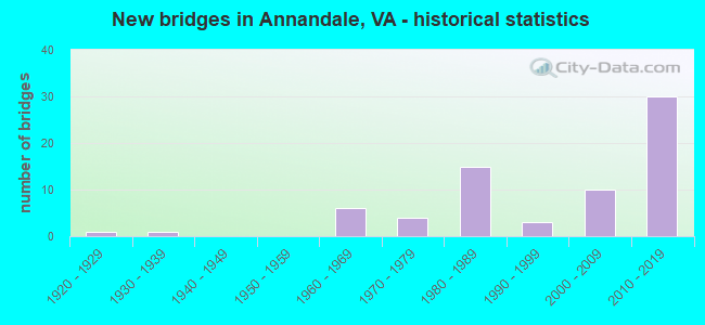
- New bridges - historical statistics
- 11920-1929
- 11930-1939
- 61960-1969
- 41970-1979
- 151980-1989
- 31990-1999
- 102000-2009
- 302010-2019
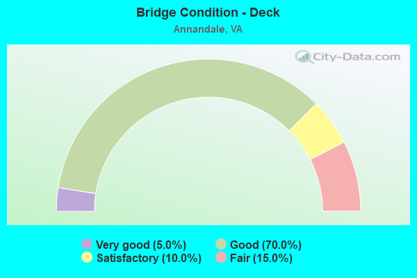
- Bridge Condition - Deck
- 5.0%Very good
- 70.0%Good
- 10.0%Satisfactory
- 15.0%Fair
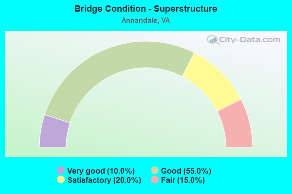
- Bridge Condition - Superstructure
- 10.0%Very good
- 55.0%Good
- 20.0%Satisfactory
- 15.0%Fair
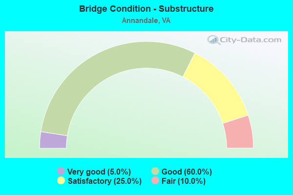
- Bridge Condition - Substructure
- 5.0%Very good
- 60.0%Good
- 25.0%Satisfactory
- 10.0%Fair
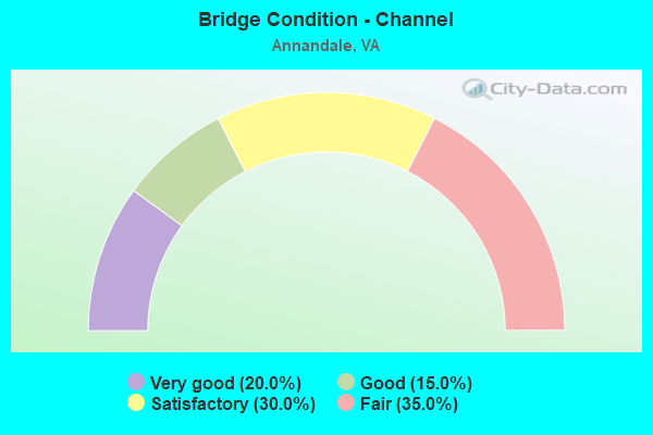
- Bridge Condition - Channel
- 20.0%Very good
- 15.0%Good
- 30.0%Satisfactory
- 35.0%Fair
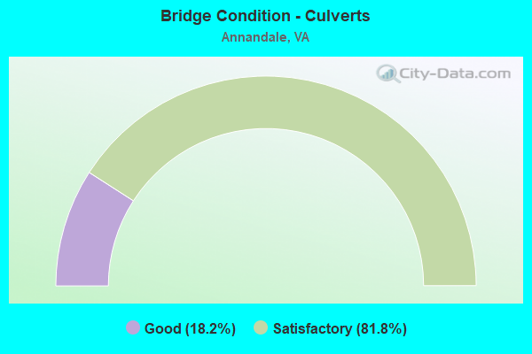
- Bridge Condition - Culverts
- 18.2%Good
- 81.8%Satisfactory
Find on map >> Show street view
Structure Number: 6178, Location: 00.47FR SB495/00.75TO29 (Lat: 38.865617, Lng: -77.213758), Route carried "on" structure: County highway 6928, Year Built: 1985, Status: Open, Structure Length: 4.27m (14.01ft), Average Daily Traffic: 12,570 (year 2020), Average Future Daily Traffic: 17,598 (year 2040), Design Load: HS 20, Features Intersected: ROUTE 50 (ARLINGTON BLVD, Facility Carried by Structure: FAIRVIEW PARK DR.
Minimum Vertical Clearance: 30+ m (98+ ft), Kilometerpoint: 0.000, Lanes on structure: 7, Lanes under structure: 9, Owner: State Highway Agency, Approaching Roadway Width: 17.4m (57.1ft), Material/Design: Steel continuous, Design/Construction: Stringer/Multi-beam, Number Of Spans In Main Unit: 2, Length of Maximum Span: 28.7m (94.2ft), Curb or Sidewalk Widths: Left: 0.2m (0.7ft), Right: 2.1m (6.9ft), Curb-To-Curb Width: 32.6m (107.0ft), Out-to-Out Width: 33.5m (109.9ft)
Condition: Deck: Satisfactory, Superstructure: Satisfactory, Substructure: Fair, Operating Rating: 43.6 metric tons, Method Used To Determine Operating Rating: Load and Resistance Factor (LRFR), Inventory Rating: 33.7 metric tons, Method Used To Determine Inventory Rating: Load and Resistance Factor (LRFR), Structural Evaluation: Somewhat better than minimum adequacy, Deck Geometry: Superior to present desirable criteria, Underclear: Meets minimum limits, Approach Roadway Alignment: Better than present minimum criteria, Length Of Structure Improvement: 4.27m (14.01ft), Designated Inspection Frequency: Every 24 months, Inspection Date: April 2021, Bridge Improvement Cost: $76,000, Roadway Improvement Cost: $120,000, Total Project Cost: $250,000, Deck Structure Type: Concrete Cast-file-Place, Wearing Surface/Protective System: Wearing Surface: Bituminous
Find on map >> Show street view
Structure Number: 6291, Location: 00.41FR495/00.19TOF-766 (Lat: 38.865831, Lng: -77.212364), Route carried "on" structure: US 50, Year Built: 1932, Status: Open, Structure Length: 0.61m (2.00ft), Average Daily Traffic: 40,895 (year 2020), Truck Traffic: 1%, Average Future Daily Traffic: 43,461 (year 2040), Design Load: HS 20, Features Intersected: HOLMES RUN, Facility Carried by Structure: ARLINGTON BLVD.
Minimum Vertical Clearance: 30+ m (98+ ft), Kilometerpoint: 123.615, Lanes on structure: 8, Base Highway Network: Yes, Owner: State Highway Agency, Approaching Roadway Width: 14.0m (45.9ft), Material/Design: Concrete, Design/Construction: Culvert, Number Of Spans In Main Unit: 3, Length of Maximum Span: 1.8m (5.9ft)
Condition: Channel: Satisfactory, Culverts: Satisfactory, Operating Rating: 89.8 metric tons, Method Used To Determine Operating Rating: Load Factor (LF), Inventory Rating: 89.7 metric tons, Method Used To Determine Inventory Rating: Load Factor (LF), Structural Evaluation: Equal to present minimum criteria, Waterway Adequacy: Better than present minimum criteria, Approach Roadway Alignment: Equal to present desirable criteria, Length Of Structure Improvement: 35.51m (116.50ft), Designated Inspection Frequency: Every 24 months, Inspection Date: July 2020, Bridge Improvement Cost: $78,000, Roadway Improvement Cost: $125,000, Total Project Cost: $250,000 ( Estimate for 2014)
Find on map >> Show street view
Structure Number: 6308, Location: 00.15FR50/00.05TOSPINE (Lat: 38.864669, Lng: -77.212672), Route carried "on" structure: Ramp US 50, Year Built: 1986, Status: Open, Structure Length: 0.88m (2.89ft), Average Daily Traffic: 4,190 (year 2018), Average Future Daily Traffic: 27,000 (year 2033), Design Load: HS 20, Features Intersected: HOLMES RUN, Facility Carried by Structure: RAMP CC & F
Minimum Vertical Clearance: 30+ m (98+ ft), Kilometerpoint: 6.758, Lanes on structure: 2, Base Highway Network: Yes, Owner: State Highway Agency, Approaching Roadway Width: 12.5m (41.0ft), Material/Design: Concrete, Design/Construction: Culvert, Number Of Spans In Main Unit: 3, Length of Maximum Span: 3.0m (9.8ft)
Condition: Channel: Satisfactory, Culverts: Satisfactory, Operating Rating: 89.8 metric tons, Method Used To Determine Operating Rating: Load Factor (LF), Inventory Rating: 89.7 metric tons, Method Used To Determine Inventory Rating: Load Factor (LF), Structural Evaluation: Equal to present minimum criteria, Waterway Adequacy: Equal to present minimum criteria, Approach Roadway Alignment: Equal to present minimum criteria, Length Of Structure Improvement: 17.47m (57.32ft), Designated Inspection Frequency: Every 24 months, Inspection Date: July 2020, Bridge Improvement Cost: $54,000, Roadway Improvement Cost: $77,000, Total Project Cost: $250,000
Find on map >> Show street view
Structure Number: 6571, Location: 00.01FR495SB 00.01TO236EB (Lat: 38.833264, Lng: -77.219794), Route carried "on" structure: Ramp Interstate 495, Year Built: 1961, Status: Open, Structure Length: 5.06m (16.60ft), Average Daily Traffic: 6,167 (year 2020), Truck Traffic: 5%, Average Future Daily Traffic: 8,634 (year 2040), Design Load: HS 20, Features Intersected: ACCOTINK CREEK
Minimum Vertical Clearance: 30+ m (98+ ft), Kilometerpoint: 0.000, Lanes on structure: 2, Base Highway Network: Yes, Owner: State Highway Agency, Approaching Roadway Width: 6.7m (22.0ft), Skew: 21 degrees, Material/Design: Steel, Design/Construction: Stringer/Multi-beam, Number Of Spans In Main Unit: 3, Length of Maximum Span: 18.3m (60.0ft), Curb-To-Curb Width: 16.2m (53.1ft), Out-to-Out Width: 16.8m (55.1ft)
Condition: Deck: Good, Superstructure: Satisfactory, Substructure: Satisfactory, Channel: Good, Operating Rating: 48.7 metric tons, Method Used To Determine Operating Rating: Load and Resistance Factor (LRFR), Inventory Rating: 37.6 metric tons, Method Used To Determine Inventory Rating: Load and Resistance Factor (LRFR), Structural Evaluation: Equal to present minimum criteria, Deck Geometry: Superior to present desirable criteria, Waterway Adequacy: Equal to present desirable criteria, Approach Roadway Alignment: Equal to present desirable criteria, Length Of Structure Improvement: 0.61m (2.00ft), Designated Inspection Frequency: Every 24 months, Inspection Date: January 2021, Bridge Improvement Cost: $100,000, Roadway Improvement Cost: $100,000, Total Project Cost: $210,000 ( Estimate for 2015), Deck Structure Type: Concrete Cast-file-Place, Wearing Surface/Protective System: Deck Protection: Epoxy Coated Reinforcing
Find on map >> Show street view
Structure Number: 659, Location: 00.01FR236/01.33TO650 (Lat: 38.834836, Lng: -77.217564), Route carried "on" structure: Interstate 495, Year Built: 1962, Status: Open, Structure Length: 0.70m (2.30ft), Average Daily Traffic: 169,257 (year 2020), Truck Traffic: 5%, Average Future Daily Traffic: 195,984 (year 2040), Design Load: HS 20, Features Intersected: BRANCH OF ACCOTINK CREEK, Facility Carried by Structure: CAPITAL BELTWAY
Minimum Vertical Clearance: 30+ m (98+ ft), Kilometerpoint: 7.047, Lanes on structure: 12, Base Highway Network: Yes, Owner: State Highway Agency, Approaching Roadway Width: 21.3m (69.9ft), Material/Design: Concrete, Design/Construction: Culvert, Number Of Spans In Main Unit: 2, Length of Maximum Span: 3.0m (9.8ft)
Condition: Channel: Satisfactory, Culverts: Satisfactory, Operating Rating: 89.8 metric tons, Method Used To Determine Operating Rating: Load Factor (LF), Inventory Rating: 89.7 metric tons, Method Used To Determine Inventory Rating: Load Factor (LF), Structural Evaluation: Equal to present minimum criteria, Waterway Adequacy: Superior to present desirable criteria, Approach Roadway Alignment: Equal to present desirable criteria, Length Of Structure Improvement: 0.61m (2.00ft), Designated Inspection Frequency: Every 24 months, Inspection Date: September 2021, Bridge Improvement Cost: $5,000, Roadway Improvement Cost: $5,000, Total Project Cost: $12,000
Find on map >> Show street view
Structure Number: 6628, Location: 00.15FR495/00.20TO236 W (Lat: 38.835469, Lng: -77.216614), Route carried "on" structure: Ramp Interstate 495, Year Built: 1962, Status: Open, Structure Length: 0.70m (2.30ft), Average Daily Traffic: 6,912 (year 2020), Average Future Daily Traffic: 9,677 (year 2040), Design Load: HS 20, Features Intersected: BRANCH OF ACCOTINK CREEK, Facility Carried by Structure: RAMPS D; H & LAFA
Minimum Vertical Clearance: 30+ m (98+ ft), Kilometerpoint: 0.000, Lanes on structure: 4, Base Highway Network: Yes, Owner: State Highway Agency, Approaching Roadway Width: 13.4m (44.0ft), Material/Design: Concrete, Design/Construction: Culvert, Number Of Spans In Main Unit: 2, Length of Maximum Span: 3.0m (9.8ft)
Condition: Channel: Good, Culverts: Satisfactory, Operating Rating: 89.8 metric tons, Method Used To Determine Operating Rating: Load Factor (LF), Inventory Rating: 56.2 metric tons, Method Used To Determine Inventory Rating: Load Factor (LF), Structural Evaluation: Equal to present minimum criteria, Waterway Adequacy: Superior to present desirable criteria, Approach Roadway Alignment: Equal to present desirable criteria, Length Of Structure Improvement: 0.61m (2.00ft), Designated Inspection Frequency: Every 24 months, Inspection Date: May 2021, Bridge Improvement Cost: $50,000, Roadway Improvement Cost: $50,000, Total Project Cost: $105,000
Find on map >> Show street view
Structure Number: 6638, Location: 00.15FR495 00.05TO50EBL (Lat: 38.865317, Lng: -77.218186), Route carried "on" structure: Ramp Interstate 495, Year Built: 1986, Status: Open, Structure Length: 3.11m (10.20ft), Average Daily Traffic: 10,739 (year 2020), Truck Traffic: 1%, Average Future Daily Traffic: 15,035 (year 2040), Design Load: HS 20, Features Intersected: RAMP B OF ROUTE 50, Facility Carried by Structure: RAMPS A AND D
Minimum Vertical Clearance: 4.64m (15.22ft), Kilometerpoint: 0.644, Lanes on structure: 2, Lanes under structure: 1, Base Highway Network: Yes, Owner: State Highway Agency, Approaching Roadway Width: 9.8m (32.2ft), Skew: 2 degrees, Material/Design: Steel, Design/Construction: Stringer/Multi-beam, Number Of Spans In Main Unit: 1, Length of Maximum Span: 31.1m (102.0ft), Curb or Sidewalk Widths: Left: 0.2m (0.7ft), Right: 0.2m (0.7ft), Curb-To-Curb Width: 9.8m (32.2ft), Out-to-Out Width: 10.8m (35.4ft)
Condition: Deck: Good, Superstructure: Satisfactory, Substructure: Satisfactory, Operating Rating: 60.2 metric tons, Method Used To Determine Operating Rating: Load and Resistance Factor (LRFR), Inventory Rating: 46.4 metric tons, Method Used To Determine Inventory Rating: Load and Resistance Factor (LRFR), Structural Evaluation: Equal to present minimum criteria, Deck Geometry: Equal to present minimum criteria, Underclear: High priority of corrective action, Approach Roadway Alignment: Equal to present desirable criteria, Length Of Structure Improvement: 3.11m (10.20ft), Designated Inspection Frequency: Every 24 months, Inspection Date: Febuary 2022, Bridge Improvement Cost: $50,000, Roadway Improvement Cost: $150,000, Total Project Cost: $250,000 ( Estimate for 2014), Deck Structure Type: Concrete Cast-file-Place, Wearing Surface/Protective System: Wearing Surface: Monolithic Concrete, Deck Protection: Epoxy Coated Reinforcing
Find on map >> Show street view
Structure Number: 6642, Location: 00.40FR.I495/00.10TO50EB (Lat: 38.865494, Lng: -77.212347), Route carried "on" structure: Ramp Interstate 495, Year Built: 1985, Status: Open, Structure Length: 3.17m (10.40ft), Average Daily Traffic: 8,000 (year 1988), Truck Traffic: 1%, Average Future Daily Traffic: 18,262 (year 2040), Design Load: HS 20, Features Intersected: RAMP CC
Minimum Vertical Clearance: 30+ m (98+ ft), Kilometerpoint: 10.700, Lanes on structure: 1, Lanes under structure: 1, Base Highway Network: Yes, Owner: State Highway Agency, Approaching Roadway Width: 9.8m (32.2ft), Skew: 2 degrees, Material/Design: Steel, Design/Construction: Stringer/Multi-beam, Number Of Spans In Main Unit: 1, Length of Maximum Span: 31.7m (104.0ft), Curb or Sidewalk Widths: Left: 0.2m (0.7ft), Right: 0.2m (0.7ft), Curb-To-Curb Width: 8.7m (28.5ft), Out-to-Out Width: 9.7m (31.8ft)
Condition: Deck: Good, Superstructure: Good, Substructure: Good, Operating Rating: 69.5 metric tons, Method Used To Determine Operating Rating: Load and Resistance Factor (LRFR), Inventory Rating: 53.6 metric tons, Method Used To Determine Inventory Rating: Load and Resistance Factor (LRFR), Structural Evaluation: Better than present minimum criteria, Deck Geometry: Superior to present desirable criteria, Underclear: High priority of corrective action, Approach Roadway Alignment: Equal to present desirable criteria, Length Of Structure Improvement: 0.30m (0.98ft), Designated Inspection Frequency: Every 24 months, Inspection Date: October 2021, Total Project Cost: $1,000, Deck Structure Type: Concrete Cast-file-Place, Wearing Surface/Protective System: Wearing Surface: Integral Concrete, Deck Protection: Epoxy Coated Reinforcing
Find on map >> Show street view
Structure Number: 6703, Location: 0.10FR2858 0.14TO822 (Lat: 38.811678, Lng: -77.194536), Route carried "on" structure: County highway 620, Year Built: 1963, Status: Open, Structure Length: 1.37m (4.49ft), Average Daily Traffic: 21,994 (year 2020), Truck Traffic: 3%, Average Future Daily Traffic: 30,792 (year 2040), Design Load: HS 20, Features Intersected: BACKLICK RUN, Facility Carried by Structure: BRADDOCK ROAD
Minimum Vertical Clearance: 30+ m (98+ ft), Kilometerpoint: 30.751, Lanes on structure: 4, Owner: State Highway Agency, Approaching Roadway Width: 15.5m (50.9ft), Skew: 4 degrees, Material/Design: Concrete, Design/Construction: Culvert, Number Of Spans In Main Unit: 3, Length of Maximum Span: 4.3m (14.1ft)
Condition: Channel: Fair, Culverts: Satisfactory, Operating Rating: 68.0 metric tons, Method Used To Determine Operating Rating: Load Factor (LF), Inventory Rating: 40.8 metric tons, Method Used To Determine Inventory Rating: Load Factor (LF), Structural Evaluation: Equal to present minimum criteria, Waterway Adequacy: Better than present minimum criteria, Approach Roadway Alignment: Better than present minimum criteria, Length Of Structure Improvement: 12.19m (39.99ft), Designated Inspection Frequency: Every 24 months, Inspection Date: July 2020, Bridge Improvement Cost: $11,000, Roadway Improvement Cost: $55,000, Total Project Cost: $79,000 ( Estimate for 2014)
Find on map >> Show street view
Structure Number: 6704, Location: 00.05FR733/00.05TO3420 (Lat: 38.811053, Lng: -77.230419), Route carried "on" structure: County highway 620, Year Built: 1972, Status: Open, Structure Length: 3.99m (13.09ft), Average Daily Traffic: 52,487 (year 2020), Truck Traffic: 1%, Average Future Daily Traffic: 73,482 (year 2040), Design Load: HS 20, Features Intersected: ACCOTINK CREEK, Facility Carried by Structure: BRADDOCK ROAD
Minimum Vertical Clearance: 30+ m (98+ ft), Kilometerpoint: 28.312, Lanes on structure: 6, Owner: State Highway Agency, Approaching Roadway Width: 15.8m (51.8ft), Skew: 20 degrees, Material/Design: Concrete continuous, Design/Construction: Slab, Number Of Spans In Main Unit: 3, Length of Maximum Span: 15.2m (49.9ft), Curb or Sidewalk Widths: Left: 0.3m (1.0ft), Right: 1.8m (5.9ft), Curb-To-Curb Width: 27.7m (90.9ft), Out-to-Out Width: 35.1m (115.2ft)
Condition: Deck: Fair, Superstructure: Fair, Substructure: Satisfactory, Channel: Good, Operating Rating: 37.3 metric tons, Method Used To Determine Operating Rating: Load and Resistance Factor (LRFR), Inventory Rating: 28.8 metric tons, Method Used To Determine Inventory Rating: Load and Resistance Factor (LRFR), Structural Evaluation: Somewhat better than minimum adequacy, Deck Geometry: Equal to present desirable criteria, Waterway Adequacy: Equal to present minimum criteria, Approach Roadway Alignment: Equal to present desirable criteria, Length Of Structure Improvement: 3.99m (13.09ft), Designated Inspection Frequency: Every 24 months, Inspection Date: August 2020, Bridge Improvement Cost: $29,000, Roadway Improvement Cost: $55,000, Total Project Cost: $100,000, Deck Structure Type: Concrete Cast-file-Place, Wearing Surface/Protective System: Wearing Surface: Latex Concrete
Find on map >> Show street view
Structure Number: 6705, Location: 00.00FR710/00.08TO3806 (Lat: 38.810919, Lng: -77.235244), Route carried "on" structure: County highway 620, Year Built: 1972, Status: Open, Structure Length: 1.34m (4.40ft), Average Daily Traffic: 47,074 (year 2020), Truck Traffic: 1%, Average Future Daily Traffic: 65,904 (year 2040), Design Load: HS 20, Features Intersected: LONG BRANCH, Facility Carried by Structure: BRADDOCK ROAD
Minimum Vertical Clearance: 30+ m (98+ ft), Kilometerpoint: 27.224, Lanes on structure: 8, Owner: State Highway Agency, Approaching Roadway Width: 17.1m (56.1ft), Skew: 2 degrees, Material/Design: Concrete, Design/Construction: Culvert, Number Of Spans In Main Unit: 4, Length of Maximum Span: 3.4m (11.2ft)
Condition: Channel: Fair, Culverts: Satisfactory, Operating Rating: 89.8 metric tons, Method Used To Determine Operating Rating: Load Factor (LF), Inventory Rating: 66.2 metric tons, Method Used To Determine Inventory Rating: Load Factor (LF), Structural Evaluation: Equal to present minimum criteria, Waterway Adequacy: Equal to present minimum criteria, Approach Roadway Alignment: Equal to present minimum criteria, Length Of Structure Improvement: 16.49m (54.10ft), Designated Inspection Frequency: Every 24 months, Inspection Date: Febuary 2021, Bridge Improvement Cost: $61,000, Roadway Improvement Cost: $81,000, Total Project Cost: $175,000
Find on map >> Show street view
Structure Number: 6778, Location: 00.04FR2354/00.03TO3490 (Lat: 38.853350, Lng: -77.197169), Route carried "on" structure: County highway 649, Year Built: 1926, Status: Posted for load, Structure Length: 1.01m (3.31ft), Average Daily Traffic: 12,627 (year 2020), Truck Traffic: 2%, Average Future Daily Traffic: 17,678 (year 2040), Design Load: HS 20, Features Intersected: HOLMES RUN, Facility Carried by Structure: ANNANDALE ROAD
Minimum Vertical Clearance: 30+ m (98+ ft), Kilometerpoint: 2.687, Lanes on structure: 2, Owner: State Highway Agency, Approaching Roadway Width: 14.6m (47.9ft), Material/Design: Concrete, Design/Construction: Tee Beam, Number Of Spans In Main Unit: 1, Length of Maximum Span: 10.1m (33.1ft), Curb or Sidewalk Widths: Left: 0.5m (1.6ft), Right: 0.5m (1.6ft), Curb-To-Curb Width: 14.6m (47.9ft), Out-to-Out Width: 16.2m (53.1ft)
Condition: Deck: Fair, Superstructure: Fair, Substructure: Satisfactory, Channel: Fair, Operating Rating: 51.5 metric tons, Method Used To Determine Operating Rating: Load Factor (LF), Inventory Rating: 30.8 metric tons, Method Used To Determine Inventory Rating: Load Factor (LF), Structural Evaluation: Somewhat better than minimum adequacy, Deck Geometry: Superior to present desirable criteria, Waterway Adequacy: Somewhat better than minimum adequacy, Approach Roadway Alignment: Better than present minimum criteria, Length Of Structure Improvement: 0.91m (2.99ft), Designated Inspection Frequency: Every 12 months, Inspection Date: April 2021, Bridge Improvement Cost: $4,000, Roadway Improvement Cost: $1,000, Total Project Cost: $6,000, Deck Structure Type: Concrete Cast-file-Place, Wearing Surface/Protective System: Wearing Surface: Bituminous
Find on map >> Show street view
Structure Number: 678, Location: 0.00FR766 / 0.70TO650 (Lat: 38.835997, Lng: -77.209817), Route carried "on" structure: County highway 649, Year Built: 1967, Status: Open, Structure Length: 0.67m (2.20ft), Average Daily Traffic: 7,562 (year 2020), Truck Traffic: 2%, Average Future Daily Traffic: 10,587 (year 2040), Design Load: HS 20, Features Intersected: TRIBUTARY OF ACCOTINK CK, Facility Carried by Structure: HUMMER ROAD
Minimum Vertical Clearance: 30+ m (98+ ft), Kilometerpoint: 0.354, Lanes on structure: 2, Owner: State Highway Agency, Approaching Roadway Width: 15.2m (49.9ft), Skew: 3 degrees, Material/Design: Concrete, Design/Construction: Culvert, Number Of Spans In Main Unit: 3, Length of Maximum Span: 2.1m (6.9ft)
Condition: Channel: Fair, Culverts: Satisfactory, Operating Rating: 89.8 metric tons, Method Used To Determine Operating Rating: Load Factor (LF), Inventory Rating: 58.1 metric tons, Method Used To Determine Inventory Rating: Load Factor (LF), Structural Evaluation: Equal to present minimum criteria, Waterway Adequacy: Somewhat better than minimum adequacy, Approach Roadway Alignment: Equal to present minimum criteria, Length Of Structure Improvement: 0.30m (0.98ft), Designated Inspection Frequency: Every 24 months, Inspection Date: June 2020, Bridge Improvement Cost: $1,000, Roadway Improvement Cost: $1,000, Total Project Cost: $3,000
Find on map >> Show street view
Structure Number: 6785, Location: 00.10FR650/00.30TO495SB (Lat: 38.865317, Lng: -77.225725), Route carried "on" structure: Ramp County highway 650, Year Built: 1985, Status: Open, Structure Length: 4.02m (13.19ft), Average Daily Traffic: 45,234 (year 2008), Truck Traffic: 2%, Average Future Daily Traffic: 75,174 (year 2040), Design Load: HS 20, Features Intersected: ROUTE 50 (RAMP E), Facility Carried by Structure: GALLOWS RD. RAMP A
Minimum Vertical Clearance: 30+ m (98+ ft), Kilometerpoint: 5.261, Lanes on structure: 2, Lanes under structure: 1, Base Highway Network: Yes, Owner: State Highway Agency, Approaching Roadway Width: 11.3m (37.1ft), Skew: 7 degrees, Material/Design: Steel, Design/Construction: Girder and Floorbeam System, Number Of Spans In Main Unit: 1, Length of Maximum Span: 39.6m (129.9ft), Curb or Sidewalk Widths: Left: 0.2m (0.7ft), Right: 0.2m (0.7ft), Curb-To-Curb Width: 11.3m (37.1ft), Out-to-Out Width: 12.2m (40.0ft)
Condition: Deck: Satisfactory, Superstructure: Satisfactory, Substructure: Satisfactory, Operating Rating: 52.0 metric tons, Method Used To Determine Operating Rating: Load and Resistance Factor (LRFR), Inventory Rating: 40.1 metric tons, Method Used To Determine Inventory Rating: Load and Resistance Factor (LRFR), Structural Evaluation: Equal to present minimum criteria, Deck Geometry: Superior to present desirable criteria, Underclear: Somewhat better than minimum adequacy, Approach Roadway Alignment: Somewhat better than minimum adequacy, Length Of Structure Improvement: 0.30m (0.98ft), Designated Inspection Frequency: Every 24 months, Critical Feature Inspection Frequency: Every 24 months, Inspection Date: April 2020, Critical Feature Inspection Date: April 2020, Bridge Improvement Cost: $3,000, Roadway Improvement Cost: $3,000, Total Project Cost: $7,000 ( Estimate for 2014), Deck Structure Type: Concrete Cast-file-Place, Wearing Surface/Protective System: Deck Protection: Epoxy Coated Reinforcing
Find on map >> Show street view
Structure Number: 6787, Location: 00.59FR3454/00.15TO495 (Lat: 38.865406, Lng: -77.227556), Route carried "on" structure: Alternate County highway 650, Year Built: 1985, Year Reconstructed: 2018, Status: Open, Structure Length: 3.90m (12.80ft), Average Daily Traffic: 29,148 (year 2020), Truck Traffic: 2%, Average Future Daily Traffic: 32,673 (year 2040), Design Load: HS 20, Features Intersected: ARLINGTON BLVD., Facility Carried by Structure: GALLOWS ROAD
Minimum Vertical Clearance: 30+ m (98+ ft), Kilometerpoint: 5.306, Lanes on structure: 8, Lanes under structure: 7, Owner: State Highway Agency, Approaching Roadway Width: 18.3m (60.0ft), Material/Design: Steel, Design/Construction: Stringer/Multi-beam, Number Of Spans In Main Unit: 2, Length of Maximum Span: 21.0m (68.9ft), Curb or Sidewalk Widths: Left: 3.5m (11.5ft), Right: 4.1m (13.5ft), Curb-To-Curb Width: 54.6m (179.1ft), Out-to-Out Width: 59.4m (194.9ft)
Condition: Deck: Good, Superstructure: Good, Substructure: Good, Operating Rating: 80.7 metric tons, Method Used To Determine Operating Rating: Load and Resistance Factor (LRFR), Inventory Rating: 62.6 metric tons, Method Used To Determine Inventory Rating: Load and Resistance Factor (LRFR), Structural Evaluation: Better than present minimum criteria, Deck Geometry: Superior to present desirable criteria, Underclear: Somewhat better than minimum adequacy, Approach Roadway Alignment: Equal to present minimum criteria, Length Of Structure Improvement: 0.30m (0.98ft), Designated Inspection Frequency: Every 24 months, Inspection Date: May 2020, Bridge Improvement Cost: $50,000, Roadway Improvement Cost: $50,000, Total Project Cost: $110,000 ( Estimate for 2015), Deck Structure Type: Concrete Precast Panels, Wearing Surface/Protective System: Wearing Surface: Latex Concrete, Deck Protection: Epoxy Coated Reinforcing
Find on map >> Show street view
Structure Number: 6876, Location: 00.30 236 / 00.08 2671 (Lat: 38.822061, Lng: -77.176981), Route carried "on" structure: County highway 712, Year Built: 1974, Status: Open, Structure Length: 0.98m (3.22ft), Average Daily Traffic: 1,113 (year 2020), Truck Traffic: 2%, Average Future Daily Traffic: 1,224 (year 2040), Design Load: HS 20, Features Intersected: INDIAN RUN, Facility Carried by Structure: COLUMBIA ROAD
Minimum Vertical Clearance: 30+ m (98+ ft), Kilometerpoint: 1.374, Lanes on structure: 2, Owner: State Highway Agency, Approaching Roadway Width: 8.8m (28.9ft), Skew: 4 degrees, Material/Design: Steel, Design/Construction: Culvert, Number Of Spans In Main Unit: 2, Length of Maximum Span: 4.6m (15.1ft)
Condition: Channel: Satisfactory, Culverts: Satisfactory, Operating Rating: 44.5 metric tons, Method Used To Determine Operating Rating: Field evaluation and documented engineering judgment, Inventory Rating: 32.7 metric tons, Method Used To Determine Inventory Rating: Field evaluation and documented engineering judgment, Structural Evaluation: Equal to present minimum criteria, Waterway Adequacy: Better than present minimum criteria, Approach Roadway Alignment: Better than present minimum criteria, Length Of Structure Improvement: 0.30m (0.98ft), Designated Inspection Frequency: Every 24 months, Inspection Date: April 2021, Bridge Improvement Cost: $1,000, Roadway Improvement Cost: $2,000, Total Project Cost: $4,000 ( Estimate for 2015)
Find on map >> Show street view
Structure Number: 691, Location: 00.20FR918/00.06TO2464 (Lat: 38.846092, Lng: -77.237636), Route carried "on" structure: County highway 846, Year Built: 1990, Status: Open, Structure Length: 1.37m (4.49ft), Average Daily Traffic: 4,344 (year 2020), Truck Traffic: 1%, Average Future Daily Traffic: 5,246 (year 2040), Design Load: HS 20, Features Intersected: ACCOTINK CREEK, Facility Carried by Structure: WOODBURN ROAD
Minimum Vertical Clearance: 30+ m (98+ ft), Kilometerpoint: 1.097, Lanes on structure: 2, Owner: State Highway Agency, Approaching Roadway Width: 10.1m (33.1ft), Material/Design: Prestressed concrete, Design/Construction: Box Beam or Girders - Multiple, Number Of Spans In Main Unit: 1, Length of Maximum Span: 13.7m (44.9ft), Curb or Sidewalk Widths: Left: 0.2m (0.7ft), Right: 0.2m (0.7ft), Curb-To-Curb Width: 10.0m (32.8ft), Out-to-Out Width: 11.2m (36.7ft)
Condition: Deck: Good, Superstructure: Good, Substructure: Good, Channel: Fair, Operating Rating: 70.8 metric tons, Method Used To Determine Operating Rating: Load and Resistance Factor (LRFR), Inventory Rating: 54.4 metric tons, Method Used To Determine Inventory Rating: Load and Resistance Factor (LRFR), Structural Evaluation: Better than present minimum criteria, Deck Geometry: Meets minimum limits, Waterway Adequacy: Equal to present desirable criteria, Approach Roadway Alignment: Equal to present desirable criteria, Length Of Structure Improvement: 1.37m (4.49ft), Designated Inspection Frequency: Every 24 months, Inspection Date: December 2020, Bridge Improvement Cost: $54,000, Roadway Improvement Cost: $79,000, Total Project Cost: $150,000, Deck Structure Type: Concrete Precast Panels, Wearing Surface/Protective System: Wearing Surface: Bituminous, Membrane: Other
Find on map >> Show street view
Structure Number: 6987, Location: 00.07 4474 / 00.11 3781 (Lat: 38.842392, Lng: -77.230833), Route carried "on" structure: County highway 3679, Year Built: 1964, Status: Open, Structure Length: 5.97m (19.59ft), Average Daily Traffic: 1,634 (year 2020), Truck Traffic: 2%, Average Future Daily Traffic: 1,797 (year 2040), Design Load: HS 20, Features Intersected: ACCOTINK CREEK, Facility Carried by Structure: KING ARTHUR ROAD
Minimum Vertical Clearance: 30+ m (98+ ft), Kilometerpoint: 0.788, Lanes on structure: 2, Owner: State Highway Agency, Approaching Roadway Width: 11.0m (36.1ft), Material/Design: Steel, Design/Construction: Stringer/Multi-beam, Number Of Spans In Main Unit: 4, Length of Maximum Span: 16.8m (55.1ft), Curb or Sidewalk Widths: Left: 0.9m (3.0ft), Right: 1.5m (4.9ft), Curb-To-Curb Width: 11.0m (36.1ft), Out-to-Out Width: 14.0m (45.9ft)
Condition: Deck: Fair, Superstructure: Fair, Substructure: Fair, Channel: Satisfactory, Operating Rating: 54.4 metric tons, Method Used To Determine Operating Rating: Load and Resistance Factor (LRFR), Inventory Rating: 41.7 metric tons, Method Used To Determine Inventory Rating: Load and Resistance Factor (LRFR), Structural Evaluation: Somewhat better than minimum adequacy, Deck Geometry: Equal to present minimum criteria, Waterway Adequacy: Better than present minimum criteria, Approach Roadway Alignment: Better than present minimum criteria, Length Of Structure Improvement: 5.97m (19.59ft), Designated Inspection Frequency: Every 24 months, Inspection Date: June 2020, Bridge Improvement Cost: $42,000, Roadway Improvement Cost: $69,000, Total Project Cost: $125,000 ( Estimate for 2014), Deck Structure Type: Concrete Cast-file-Place, Wearing Surface/Protective System: Wearing Surface: Latex Concrete
Find on map >> Show street view
Structure Number: 7003, Location: 00.04 4455 / 00.04 4675 (Lat: 38.817975, Lng: -77.249378), Route carried "on" structure: County highway 4693, Year Built: 1972, Status: Open, Structure Length: 1.28m (4.20ft), Average Daily Traffic: 2,549 (year 2009), Average Future Daily Traffic: 2,944 (year 2040), Design Load: HS 20, Features Intersected: LONG BRANCH, Facility Carried by Structure: WOODLAND WAY
Minimum Vertical Clearance: 30+ m (98+ ft), Kilometerpoint: 0.890, Lanes on structure: 2, Owner: State Highway Agency, Approaching Roadway Width: 11.0m (36.1ft), Material/Design: Concrete, Design/Construction: Culvert, Number Of Spans In Main Unit: 4, Length of Maximum Span: 3.0m (9.8ft)
Condition: Channel: Fair, Culverts: Satisfactory, Operating Rating: 89.8 metric tons, Method Used To Determine Operating Rating: Load Factor (LF), Inventory Rating: 55.3 metric tons, Method Used To Determine Inventory Rating: Load Factor (LF), Structural Evaluation: Equal to present minimum criteria, Waterway Adequacy: Better than present minimum criteria, Approach Roadway Alignment: Better than present minimum criteria, Length Of Structure Improvement: 9.14m (29.99ft), Designated Inspection Frequency: Every 24 months, Inspection Date: January 2021, Bridge Improvement Cost: $45,000, Roadway Improvement Cost: $55,000, Total Project Cost: $125,000
Find on map >> Show street view
Structure Number: 23643, Location: 00.25RF710/00.15TO4488 (Lat: 38.822356, Lng: -77.234886), Route carried "on" structure: County highway 4491, Year Built: 1993, Status: Open, Structure Length: 0.64m (2.10ft), Average Daily Traffic: 793 (year 2009), Average Future Daily Traffic: 916 (year 2040), Design Load: HS 20+Mod, Features Intersected: TRIBUTARY OF ACCOTINK CK, Facility Carried by Structure: HOLBORN AVE.
Minimum Vertical Clearance: 30+ m (98+ ft), Kilometerpoint: 0.000, Lanes on structure: 2, Owner: State Highway Agency, Approaching Roadway Width: 6.4m (21.0ft), Skew: 1 degrees, Material/Design: Concrete, Design/Construction: Culvert, Number Of Spans In Main Unit: 2, Length of Maximum Span: 3.0m (9.8ft)
Condition: Channel: Fair, Culverts: Good, Operating Rating: 68.9 metric tons, Method Used To Determine Operating Rating: Load Factor (LF), Inventory Rating: 40.8 metric tons, Method Used To Determine Inventory Rating: Load Factor (LF), Structural Evaluation: Better than present minimum criteria, Waterway Adequacy: Better than present minimum criteria, Approach Roadway Alignment: Better than present minimum criteria, Length Of Structure Improvement: 3.11m (10.20ft), Designated Inspection Frequency: Every 24 months, Inspection Date: May 2020, Bridge Improvement Cost: $43,000, Roadway Improvement Cost: $56,000, Total Project Cost: $150,000 ( Estimate for 2014)
Find on map >> Show street view
Structure Number: 24663, Location: 00.30FR END/00.20TO4491 (Lat: 38.820392, Lng: -77.231983), Route carried "on" structure: County highway 7965, Year Built: 1995, Status: Open, Structure Length: 0.67m (2.20ft), Average Daily Traffic: 418 (year 2003), Average Future Daily Traffic: 495 (year 2040), Design Load: HS 20, Features Intersected: TURKEY RUN, Facility Carried by Structure: PRIVATE LANE
Minimum Vertical Clearance: 30+ m (98+ ft), Kilometerpoint: 0.000, Lanes on structure: 2, Owner: State Highway Agency, Approaching Roadway Width: 9.1m (29.9ft), Skew: 1 degrees, Material/Design: Aluminum, Iron, Design/Construction: Culvert, Number Of Spans In Main Unit: 2, Length of Maximum Span: 2.7m (8.9ft)
Condition: Channel: Satisfactory, Culverts: Good, Operating Rating: 44.5 metric tons, Method Used To Determine Operating Rating: Load Factor (LF), Inventory Rating: 32.7 metric tons, Method Used To Determine Inventory Rating: Load Factor (LF), Structural Evaluation: Better than present minimum criteria, Waterway Adequacy: Better than present minimum criteria, Approach Roadway Alignment: Equal to present desirable criteria, Length Of Structure Improvement: 3.54m (11.61ft), Designated Inspection Frequency: Every 24 months, Inspection Date: April 2021, Bridge Improvement Cost: $35,000, Roadway Improvement Cost: $90,000, Total Project Cost: $175,000
Find on map >> Show street view
Structure Number: 28655, Location: 00.27FRLAKE/00.43TO0649 (Lat: 38.834278, Lng: -77.219028), Route carried "on" structure: State highway 236, Year Built: 2011, Status: Open, Structure Length: 14.82m (48.62ft), Average Daily Traffic: 20,830 (year 2020), Truck Traffic: 1%, Average Future Daily Traffic: 29,163 (year 2040), Design Load: HS 20, Features Intersected: I-495; HOV; Accotink CK
Minimum Vertical Clearance: 30+ m (98+ ft), Kilometerpoint: 0.000, Lanes on structure: 3, Lanes under structure: 16, Base Highway Network: Yes, Owner: State Highway Agency, Approaching Roadway Width: 18.3m (60.0ft), Skew: 1 degrees, Material/Design: Steel continuous, Design/Construction: Stringer/Multi-beam, Number Of Spans In Main Unit: 5, Length of Maximum Span: 36.6m (120.1ft), Curb-To-Curb Width: 11.0m (36.1ft), Out-to-Out Width: 17.7m (58.1ft)
Condition: Deck: Good, Superstructure: Good, Substructure: Good, Channel: Very good, Operating Rating: 48.9 metric tons, Method Used To Determine Operating Rating: Load and Resistance Factor (LRFR), Inventory Rating: 37.7 metric tons, Method Used To Determine Inventory Rating: Load and Resistance Factor (LRFR), Structural Evaluation: Better than present minimum criteria, Deck Geometry: High priority of replacement, Underclear: High priority of corrective action, Approach Roadway Alignment: Equal to present desirable criteria, Length Of Structure Improvement: 0.30m (0.98ft), Designated Inspection Frequency: Every 24 months, Inspection Date: August 2021, Bridge Improvement Cost: $1,000, Roadway Improvement Cost: $1,000, Total Project Cost: $3,000 ( Estimate for 2015), Deck Structure Type: Concrete Cast-file-Place, Wearing Surface/Protective System: Wearing Surface: Monolithic Concrete, Deck Protection: Epoxy Coated Reinforcing
Find on map >> Show street view
Structure Number: 28656, Location: 1.12fr710 & 0.40to649 (Lat: 38.834806, Lng: -77.219028), Route carried "on" structure: State highway 236, Year Built: 2011, Status: Open, Structure Length: 14.84m (48.69ft), Average Daily Traffic: 20,830 (year 2020), Truck Traffic: 1%, Average Future Daily Traffic: 29,163 (year 2040), Design Load: HS 20, Features Intersected: I-495; HOV; Accotink CK
Minimum Vertical Clearance: 30+ m (98+ ft), Kilometerpoint: 0.000, Lanes on structure: 3, Lanes under structure: 16, Owner: State Highway Agency, Approaching Roadway Width: 14.3m (46.9ft), Material/Design: Steel continuous, Design/Construction: Stringer/Multi-beam, Number Of Spans In Main Unit: 5, Length of Maximum Span: 36.6m (120.1ft), Curb or Sidewalk Widths: Left: 0.0m, Right: 3.2m (10.5ft), Curb-To-Curb Width: 11.0m (36.1ft), Out-to-Out Width: 14.3m (46.9ft)
Condition: Deck: Good, Superstructure: Good, Substructure: Good, Channel: Very good, Operating Rating: 51.2 metric tons, Method Used To Determine Operating Rating: Load and Resistance Factor (LRFR), Inventory Rating: 39.5 metric tons, Method Used To Determine Inventory Rating: Load and Resistance Factor (LRFR), Structural Evaluation: Better than present minimum criteria, Deck Geometry: High priority of replacement, Underclear: High priority of corrective action, Waterway Adequacy: Better than present minimum criteria, Approach Roadway Alignment: Equal to present desirable criteria, Designated Inspection Frequency: Every 24 months, Inspection Date: August 2021, Deck Structure Type: Concrete Cast-file-Place, Wearing Surface/Protective System: Wearing Surface: Monolithic Concrete, Deck Protection: Epoxy Coated Reinforcing
Find on map >> Show street view
Structure Number: 28657, Location: 00.04FR495 / 00.06TO236 (Lat: 38.836311, Lng: -77.219483), Route carried "on" structure: Ramp State highway 236, Year Built: 2011, Status: Open, Structure Length: 5.52m (18.11ft), Average Daily Traffic: 4,543 (year 2020), Truck Traffic: 2%, Average Future Daily Traffic: 6,360 (year 2040), Design Load: HS 20, Features Intersected: ACCOTINK CREEK, Facility Carried by Structure: RAMP LRNW
Minimum Vertical Clearance: 30+ m (98+ ft), Kilometerpoint: 0.000, Lanes on structure: 1, Base Highway Network: Yes, Owner: State Highway Agency, Approaching Roadway Width: 9.0m (29.5ft), Skew: 1 degrees, Material/Design: Steel continuous, Design/Construction: Stringer/Multi-beam, Number Of Spans In Main Unit: 3, Length of Maximum Span: 20.7m (67.9ft), Curb-To-Curb Width: 9.0m (29.5ft), Out-to-Out Width: 10.1m (33.1ft)
Condition: Deck: Good, Superstructure: Very good, Substructure: Good, Channel: Very good, Inventory Rating: 89.8 metric tons, Method Used To Determine Inventory Rating: Load and Resistance Factor (LRFR), Structural Evaluation: Better than present minimum criteria, Deck Geometry: Superior to present desirable criteria, Waterway Adequacy: Equal to present minimum criteria, Approach Roadway Alignment: Somewhat better than minimum adequacy, Designated Inspection Frequency: Every 24 months, Inspection Date: March 2021, Deck Structure Type: Concrete Cast-file-Place, Wearing Surface/Protective System: Wearing Surface: Monolithic Concrete, Deck Protection: Epoxy Coated Reinforcing
Find on map >> Show street view
Structure Number: 28668, Location: 00.14FR2264/00.14TO0867 (Lat: 38.853961, Lng: -77.220539), Route carried "on" structure: Alternate County highway 650, Year Built: 2010, Status: Open, Structure Length: 9.93m (32.58ft), Average Daily Traffic: 20,548 (year 2020), Truck Traffic: 2%, Average Future Daily Traffic: 28,767 (year 2040), Design Load: HS 20, Features Intersected: I-495, Facility Carried by Structure: GALLOWS ROAD
Minimum Vertical Clearance: 6.02m (19.75ft), Kilometerpoint: 0.000, Lanes on structure: 6, Lanes under structure: 14, Owner: State Highway Agency, Approaching Roadway Width: 12.2m (40.0ft), Skew: 13 degrees, Material/Design: Steel continuous, Design/Construction: Stringer/Multi-beam, Number Of Spans In Main Unit: 2, Length of Maximum Span: 49.3m (161.7ft), Curb or Sidewalk Widths: Left: 1.7m (5.6ft), Right: 3.2m (10.5ft), Curb-To-Curb Width: 11.0m (36.1ft), Out-to-Out Width: 32.2m (105.6ft)
Condition: Deck: Good, Superstructure: Good, Substructure: Good, Operating Rating: 39.3 metric tons, Method Used To Determine Operating Rating: Load and Resistance Factor (LRFR), Inventory Rating: 30.3 metric tons, Method Used To Determine Inventory Rating: Load and Resistance Factor (LRFR), Structural Evaluation: Better than present minimum criteria, Deck Geometry: High priority of replacement, Underclear: High priority of corrective action, Approach Roadway Alignment: Equal to present desirable criteria, Length Of Structure Improvement: 0.30m (0.98ft), Designated Inspection Frequency: Every 24 months, Inspection Date: May 2020, Bridge Improvement Cost: $1,000, Roadway Improvement Cost: $1,000, Total Project Cost: $3,000 ( Estimate for 2014), Deck Structure Type: Concrete Cast-file-Place, Wearing Surface/Protective System: Wearing Surface: Integral Concrete, Deck Protection: Epoxy Coated Reinforcing
Find on map >> Show street view
Structure Number: 28669, Location: 0.76FR650 / 1.33TO66 (Lat: 38.865472, Lng: -77.219714), Route carried "on" structure: Ramp County highway 495, Year Built: 2009, Status: Open, Structure Length: 5.76m (18.90ft), Average Daily Traffic: 25,000 (year 2009), Truck Traffic: 3%, Average Future Daily Traffic: 38,000 (year 2034), Design Load: HS 20, Features Intersected: RTE.50, Facility Carried by Structure: RAMPS ASCN; AWN
Minimum Vertical Clearance: 30.18m (99.02ft), Kilometerpoint: 0.000, Lanes on structure: 2, Lanes under structure: 10, Base Highway Network: Yes, Owner: State Highway Agency, Approaching Roadway Width: 11.6m (38.1ft), Material/Design: Prestressed concrete, Design/Construction: Stringer/Multi-beam, Number Of Spans In Main Unit: 2, Length of Maximum Span: 29.4m (96.5ft), Curb-To-Curb Width: 11.6m (38.1ft), Out-to-Out Width: 12.5m (41.0ft)
Condition: Deck: Good, Superstructure: Good, Substructure: Good, Operating Rating: 67.9 metric tons, Method Used To Determine Operating Rating: Load and Resistance Factor (LRFR), Inventory Rating: 49.2 metric tons, Method Used To Determine Inventory Rating: Load and Resistance Factor (LRFR), Structural Evaluation: Better than present minimum criteria, Deck Geometry: Superior to present desirable criteria, Underclear: High priority of corrective action, Approach Roadway Alignment: Better than present minimum criteria, Length Of Structure Improvement: 0.30m (0.98ft), Designated Inspection Frequency: Every 24 months, Inspection Date: Febuary 2022, Bridge Improvement Cost: $1,000, Roadway Improvement Cost: $1,000, Total Project Cost: $3,000 ( Estimate for 2014), Deck Structure Type: Concrete Cast-file-Place, Wearing Surface/Protective System: Wearing Surface: Integral Concrete, Deck Protection: Epoxy Coated Reinforcing
Find on map >> Show street view
Structure Number: 2867, Location: 00.83FR0650/01.29TO0066 (Lat: 38.865531, Lng: -77.219931), Route carried "on" structure: Interstate 495, Year Built: 2010, Status: Open, Structure Length: 5.64m (18.50ft), Average Daily Traffic: 71,370 (year 2020), Truck Traffic: 5%, Average Future Daily Traffic: 90,783 (year 2040), Design Load: HS 20, Features Intersected: RTE.50
Minimum Vertical Clearance: 30.45m (99.90ft), Kilometerpoint: 0.000, Lanes on structure: 6, Lanes under structure: 11, Base Highway Network: Yes, Owner: State Highway Agency, Approaching Roadway Width: 30.4m (99.7ft), Material/Design: Prestressed concrete, Design/Construction: Stringer/Multi-beam, Number Of Spans In Main Unit: 2, Length of Maximum Span: 28.2m (92.5ft), Curb-To-Curb Width: 21.9m (71.9ft), Out-to-Out Width: 30.5m (100.1ft)
Condition: Deck: Very good, Superstructure: Good, Substructure: Very good, Operating Rating: 74.2 metric tons, Method Used To Determine Operating Rating: Load and Resistance Factor (LRFR), Inventory Rating: 56.2 metric tons, Method Used To Determine Inventory Rating: Load and Resistance Factor (LRFR), Structural Evaluation: Better than present minimum criteria, Deck Geometry: High priority of replacement, Underclear: High priority of corrective action, Approach Roadway Alignment: Equal to present desirable criteria, Length Of Structure Improvement: 0.30m (0.98ft), Designated Inspection Frequency: Every 24 months, Inspection Date: September 2020, Bridge Improvement Cost: $50,000, Roadway Improvement Cost: $50,000, Total Project Cost: $120,000 ( Estimate for 2014), Deck Structure Type: Concrete Cast-file-Place, Wearing Surface/Protective System: Wearing Surface: Integral Concrete, Deck Protection: Epoxy Coated Reinforcing
Find on map >> Show street view
Structure Number: 28672, Location: 00.83FR650/01.29TO66 (Lat: 38.865494, Lng: -77.220622), Route carried "on" structure: Ramp Interstate 495, Year Built: 2009, Status: Open, Structure Length: 5.64m (18.50ft), Average Daily Traffic: 12,000 (year 2009), Truck Traffic: 1%, Average Future Daily Traffic: 18,000 (year 2034), Design Load: HS 20, Features Intersected: ROUTE 50, Facility Carried by Structure: RAMPS ACNS;AES;ANE
Minimum Vertical Clearance: 30.45m (99.90ft), Kilometerpoint: 0.000, Lanes on structure: 2, Lanes under structure: 10, Base Highway Network: Yes, Owner: State Highway Agency, Approaching Roadway Width: 11.6m (38.1ft), Material/Design: Concrete, Design/Construction: Stringer/Multi-beam, Number Of Spans In Main Unit: 2, Length of Maximum Span: 28.2m (92.5ft), Curb-To-Curb Width: 11.6m (38.1ft), Out-to-Out Width: 12.5m (41.0ft)
Condition: Deck: Good, Superstructure: Good, Substructure: Good, Operating Rating: 70.7 metric tons, Method Used To Determine Operating Rating: Load and Resistance Factor (LRFR), Inventory Rating: 54.5 metric tons, Method Used To Determine Inventory Rating: Load and Resistance Factor (LRFR), Structural Evaluation: Better than present minimum criteria, Deck Geometry: Superior to present desirable criteria, Underclear: High priority of corrective action, Approach Roadway Alignment: Equal to present desirable criteria, Length Of Structure Improvement: 3.05m (10.01ft), Designated Inspection Frequency: Every 24 months, Inspection Date: January 2022, Bridge Improvement Cost: $10,000, Roadway Improvement Cost: $10,000, Total Project Cost: $25,000 ( Estimate for 2014), Deck Structure Type: Concrete Cast-file-Place, Wearing Surface/Protective System: Wearing Surface: Monolithic Concrete, Deck Protection: Epoxy Coated Reinforcing
Find on map >> Show street view
Structure Number: 28693, Location: 00.92FR71/ 00.70TO Ravens (Lat: 38.811389, Lng: -77.218461), Route carried "on" structure: County highway 620, Year Built: 2010, Status: Open, Structure Length: 15.03m (49.31ft), Average Daily Traffic: 52,487 (year 2020), Truck Traffic: 3%, Average Future Daily Traffic: 73,482 (year 2040), Design Load: HS 20, Features Intersected: I-495
Minimum Vertical Clearance: 30+ m (98+ ft), Kilometerpoint: 0.000, Lanes on structure: 8, Lanes under structure: 15, Owner: State Highway Agency, Approaching Roadway Width: 14.0m (45.9ft), Skew: 22 degrees, Material/Design: Steel continuous, Design/Construction: Stringer/Multi-beam, Number Of Spans In Main Unit: 4, Length of Maximum Span: 47.4m (155.5ft), Curb or Sidewalk Widths: Left: 3.2m (10.5ft), Right: 0.0m, Curb-To-Curb Width: 11.0m (36.1ft), Out-to-Out Width: 40.4m (132.5ft)
Condition: Deck: Good, Superstructure: Good, Substructure: Good, Operating Rating: 63.2 metric tons, Method Used To Determine Operating Rating: Load and Resistance Factor (LRFR), Inventory Rating: 48.8 metric tons, Method Used To Determine Inventory Rating: Load and Resistance Factor (LRFR), Structural Evaluation: Better than present minimum criteria, Deck Geometry: High priority of replacement, Underclear: Meets minimum limits, Approach Roadway Alignment: Equal to present desirable criteria, Length Of Structure Improvement: 0.03m (0.10ft), Designated Inspection Frequency: Every 24 months, Inspection Date: May 2020, Deck Structure Type: Concrete Cast-file-Place, Wearing Surface/Protective System: Wearing Surface: Monolithic Concrete, Deck Protection: Galvanized Reinforcing
Find on map >> Show street view
Structure Number: 28695, Location: 0.02fr236 WB 0.02to 495 (Lat: 38.835861, Lng: -77.219739), Route carried "on" structure: Ramp US 236, Year Built: 2012, Status: Open, Structure Length: 5.79m (19.00ft), Average Daily Traffic: 3,805 (year 2020), Truck Traffic: 1%, Average Future Daily Traffic: 5,327 (year 2040), Design Load: HS 20, Features Intersected: Accotink Crk. H/B trail
Minimum Vertical Clearance: 30.18m (99.02ft), Kilometerpoint: 0.000, Lanes on structure: 1, Owner: State Highway Agency, Approaching Roadway Width: 9.1m (29.9ft), Skew: 3 degrees, Material/Design: Steel continuous, Design/Construction: Stringer/Multi-beam, Number Of Spans In Main Unit: 3, Length of Maximum Span: 21.6m (70.9ft), Curb-To-Curb Width: 6.7m (22.0ft), Out-to-Out Width: 10.1m (33.1ft)
Condition: Deck: Good, Superstructure: Very good, Substructure: Good, Channel: Very good, Operating Rating: 83.6 metric tons, Method Used To Determine Operating Rating: Load and Resistance Factor (LRFR), Inventory Rating: 64.3 metric tons, Method Used To Determine Inventory Rating: Load and Resistance Factor (LRFR), Structural Evaluation: Better than present minimum criteria, Deck Geometry: Equal to present minimum criteria, Waterway Adequacy: Better than present minimum criteria, Approach Roadway Alignment: Somewhat better than minimum adequacy, Length Of Structure Improvement: 0.30m (0.98ft), Designated Inspection Frequency: Every 24 months, Inspection Date: Febuary 2022, Bridge Improvement Cost: $1,000, Roadway Improvement Cost: $1,000, Total Project Cost: $3,000 ( Estimate for 2014), Deck Structure Type: Concrete Cast-file-Place, Wearing Surface/Protective System: Wearing Surface: Monolithic Concrete, Deck Protection: Epoxy Coated Reinforcing
Find on map >> Show street view
Structure Number: 29186, Location: .01FR 620 TO.2 495NB (Lat: 38.812833, Lng: -77.219306), Route carried "on" structure: Ramp County highway 620, Year Built: 2012, Status: Open, Structure Length: 15.54m (50.98ft), Average Daily Traffic: 10,000 (year 2012), Truck Traffic: 3%, Average Future Daily Traffic: 20,000 (year 2034), Design Load: HS 20, Features Intersected: I-495 SB and HOT lanes, Facility Carried by Structure: RAMPS BNEWH &BEWNH
Minimum Vertical Clearance: 30+ m (98+ ft), Kilometerpoint: 0.000, Lanes on structure: 2, Lanes under structure: 7, Owner: State Highway Agency, Maintenance Responsibility: Private, Approaching Roadway Width: 19.5m (64.0ft), Skew: 30 degrees, Material/Design: Concrete, Design/Construction: Slab, Number Of Spans In Main Unit: 4, Number Of Approach Spans: 2, Length of Maximum Span: 45.7m (149.9ft), Curb-To-Curb Width: 10.2m (33.5ft), Out-to-Out Width: 19.5m (64.0ft)
Condition: Deck: Good, Superstructure: Good, Substructure: Good, Operating Rating: 89.8 metric tons, Method Used To Determine Operating Rating: Load and Resistance Factor (LRFR), Inventory Rating: 87.1 metric tons, Method Used To Determine Inventory Rating: Load and Resistance Factor (LRFR), Structural Evaluation: Better than present minimum criteria, Deck Geometry: Equal to present minimum criteria, Approach Roadway Alignment: Equal to present desirable criteria, Length Of Structure Improvement: 0.30m (0.98ft), Designated Inspection Frequency: Every 24 months, Critical Feature Inspection Frequency: Every 24 months, Inspection Date: September 2020, Critical Feature Inspection Date: September 2021, Bridge Improvement Cost: $1,000, Roadway Improvement Cost: $1,000, Total Project Cost: $3,000 ( Estimate for 2016), Deck Structure Type: Concrete Cast-file-Place, Wearing Surface/Protective System: Wearing Surface: Monolithic Concrete, Membrane: Epoxy, Deck Protection: Epoxy Coated Reinforcing
Find on map >> Show street view
Structure Number: 6178, Location: 00.47FR SB495/00.75TO29 (Lat: 38.865617, Lng: -77.213758), Route carried "under" structure: US 50, Year Built: 1985, Structure Length: 0. m, Average Daily Traffic: 52,680 (year 2008), Features Intersected: ROUTE 50 (ARLINGTON BLVD, Facility Carried by Structure: FAIRVIEW PARK DR.
Minimum Vertical Clearance: 5.18m (16.99ft), Kilometerpoint: 123.668, Lanes on structure: 7, Lanes under structure: 4, Material/Design: Steel continuous, Design/Construction: Stringer/Multi-beam, Length of Maximum Span: 28.7m (94.2ft)
Find on map >> Show street view
Structure Number: 6178, Location: 00.47FR SB495/00.75TO29 (Lat: 38.865617, Lng: -77.213758), Route carried "under" structure: US 50, Year Built: 1985, Structure Length: 0. m, Average Daily Traffic: 52,680 (year 2008), Features Intersected: ROUTE 50 (ARLINGTON BLVD, Facility Carried by Structure: FAIRVIEW PARK DR.
Minimum Vertical Clearance: 4.75m (15.58ft), Kilometerpoint: 123.684, Lanes on structure: 7, Lanes under structure: 4, Material/Design: Steel continuous, Design/Construction: Stringer/Multi-beam, Length of Maximum Span: 28.7m (94.2ft)
Find on map >> Show street view
Structure Number: 6178, Location: 00.47FR SB495/00.75TO29 (Lat: 38.865617, Lng: -77.213758), Route carried "under" structure: Ramp Other road 50, Year Built: 1985, Structure Length: 0. m, Features Intersected: ROUTE 50 (ARLINGTON BLVD, Facility Carried by Structure: FAIRVIEW PARK DR.
Minimum Vertical Clearance: 4.65m (15.26ft), Kilometerpoint: 0.000, Lanes on structure: 7, Lanes under structure: 1, Material/Design: Steel continuous, Design/Construction: Stringer/Multi-beam, Length of Maximum Span: 28.7m (94.2ft)
Find on map >> Show street view
Structure Number: 6638, Location: 00.15FR495 00.05TO50EBL (Lat: 38.865317, Lng: -77.218186), Route carried "under" structure: Ramp Interstate 50, Year Built: 1986, Structure Length: 0. m, Average Daily Traffic: 5,000 (year 1992), Features Intersected: RAMP B OF ROUTE 50, Facility Carried by Structure: RAMPS A AND D
Minimum Vertical Clearance: 4.85m (15.91ft), Kilometerpoint: 0.080, Lanes on structure: 2, Lanes under structure: 1, Material/Design: Steel, Design/Construction: Stringer/Multi-beam, Length of Maximum Span: 31.1m (102.0ft)
Find on map >> Show street view
Structure Number: 664, Location: 0020FR495SBL 0010TOFAIR D (Lat: 38.865272, Lng: -77.217217), Route carried "under" structure: Ramp Interstate 495, Year Built: 1986, Structure Length: 0. m, Average Daily Traffic: 8,250 (year 1994), Features Intersected: RAMP C_OF RTE.495
Minimum Vertical Clearance: 4.47m (14.67ft), Kilometerpoint: 0.000, Lanes on structure: 1, Lanes under structure: 1, Material/Design: Steel continuous, Design/Construction: Stringer/Multi-beam, Length of Maximum Span: 26.2m (86.0ft)
Find on map >> Show street view
Structure Number: 6642, Location: 00.40FR.I495/00.10TO50EB (Lat: 38.865494, Lng: -77.212347), Route carried "under" structure: Ramp Interstate 50, Year Built: 1985, Structure Length: 0. m, Average Daily Traffic: 5,500 (year 1994), Truck Traffic: 1%, Features Intersected: RAMP CC, Facility Carried by Structure: I495 RAMP C
Minimum Vertical Clearance: 4.57m (14.99ft), Kilometerpoint: 10.700, Lanes on structure: 1, Lanes under structure: 1, Material/Design: Steel, Design/Construction: Stringer/Multi-beam, Length of Maximum Span: 31.7m (104.0ft)
Find on map >> Show street view
Structure Number: 6785, Location: 00.10FR650/00.30TO495SB (Lat: 38.865317, Lng: -77.225725), Route carried "under" structure: Ramp County highway 50, Year Built: 1985, Structure Length: 0. m, Average Daily Traffic: 14,200 (year 1994), Features Intersected: ROUTE 50 (RAMP E), Facility Carried by Structure: GALLOWS RD. RAMP A
Minimum Vertical Clearance: 5.13m (16.83ft), Kilometerpoint: 0.000, Lanes on structure: 2, Lanes under structure: 1, Material/Design: Steel, Design/Construction: Girder and Floorbeam System, Length of Maximum Span: 39.6m (129.9ft)
Find on map >> Show street view
Structure Number: 6787, Location: 00.59FR3454/00.15TO495 (Lat: 38.865406, Lng: -77.227556), Route carried "under" structure: US 50, Year Built: 1985, Structure Length: 0. m, Average Daily Traffic: 42,416 (year 2008), Truck Traffic: 1%, Features Intersected: ARLINGTON BLVD., Facility Carried by Structure: GALLOWS ROAD
Minimum Vertical Clearance: 5.13m (16.83ft), Kilometerpoint: 122.348, Lanes on structure: 8, Lanes under structure: 3, Material/Design: Steel, Design/Construction: Stringer/Multi-beam, Length of Maximum Span: 21.0m (68.9ft)
Find on map >> Show street view
Structure Number: 6787, Location: 00.59FR3454/00.15TO495 (Lat: 38.865406, Lng: -77.227556), Route carried "under" structure: US 50, Year Built: 1985, Structure Length: 0. m, Average Daily Traffic: 42,416 (year 2008), Truck Traffic: 1%, Features Intersected: ARLINGTON BLVD., Facility Carried by Structure: GALLOWS ROAD
Minimum Vertical Clearance: 5.28m (17.32ft), Kilometerpoint: 122.364, Lanes on structure: 8, Lanes under structure: 4, Material/Design: Steel, Design/Construction: Stringer/Multi-beam, Length of Maximum Span: 21.0m (68.9ft)
Find on map >> Show street view
Structure Number: 28655, Location: 00.27FRLAKE/00.43TO0649 (Lat: 38.834278, Lng: -77.219028), Route carried "under" structure: Ramp Interstate 495, Year Built: 2011, Structure Length: 0. m, Average Daily Traffic: 20,000 (year 2010), Truck Traffic: 1%, Features Intersected: I-495; HOV; Accotink CK, Facility Carried by Structure: RTE.236 EB
Minimum Vertical Clearance: 5.79m (19.00ft), Kilometerpoint: 0.000, Lanes on structure: 3, Lanes under structure: 2, Material/Design: Steel continuous, Design/Construction: Stringer/Multi-beam, Length of Maximum Span: 36.6m (120.1ft)
Find on map >> Show street view
Structure Number: 28655, Location: 00.27FRLAKE/00.43TO0649 (Lat: 38.834278, Lng: -77.219028), Route carried "under" structure: Interstate 495, Year Built: 2011, Structure Length: 0. m, Average Daily Traffic: 80,000 (year 2010), Truck Traffic: 3%, Features Intersected: I-495; HOV; Accotink CK, Facility Carried by Structure: RTE.236 EB
Minimum Vertical Clearance: 6.30m (20.67ft), Kilometerpoint: 0.000, Lanes on structure: 3, Lanes under structure: 6, Material/Design: Steel continuous, Design/Construction: Stringer/Multi-beam, Length of Maximum Span: 36.6m (120.1ft)
Find on map >> Show street view
Structure Number: 28655, Location: 00.27FRLAKE/00.43TO0649 (Lat: 38.834278, Lng: -77.219028), Route carried "under" structure: Ramp Interstate 495, Year Built: 2011, Structure Length: 0. m, Average Daily Traffic: 20,000 (year 2010), Truck Traffic: 1%, Features Intersected: I-495; HOV; Accotink CK, Facility Carried by Structure: RTE.236 EB
Minimum Vertical Clearance: 5.21m (17.09ft), Kilometerpoint: 0.000, Lanes on structure: 3, Lanes under structure: 2, Material/Design: Steel continuous, Design/Construction: Stringer/Multi-beam, Length of Maximum Span: 36.6m (120.1ft)
Find on map >> Show street view
Structure Number: 28655, Location: 00.27FRLAKE/00.43TO0649 (Lat: 38.834278, Lng: -77.219028), Route carried "under" structure: Interstate 495, Year Built: 2011, Structure Length: 0. m, Average Daily Traffic: 80,000 (year 2010), Truck Traffic: 3%, Features Intersected: I-495; HOV; Accotink CK, Facility Carried by Structure: RTE.236 EB
Minimum Vertical Clearance: 5.94m (19.49ft), Kilometerpoint: 0.000, Lanes on structure: 3, Lanes under structure: 6, Material/Design: Steel continuous, Design/Construction: Stringer/Multi-beam, Length of Maximum Span: 36.6m (120.1ft)
Find on map >> Show street view
Structure Number: 28656, Location: 1.12fr710 & 0.40to649 (Lat: 38.834806, Lng: -77.219028), Route carried "under" structure: Ramp Interstate 495, Year Built: 2011, Structure Length: 0. m, Average Daily Traffic: 14,000 (year 2011), Truck Traffic: 10%, Features Intersected: I-495; HOV; Accotink CK, Facility Carried by Structure: RTE.236 WB
Minimum Vertical Clearance: 5.28m (17.32ft), Kilometerpoint: 0.000, Lanes on structure: 3, Lanes under structure: 2, Material/Design: Steel continuous, Design/Construction: Stringer/Multi-beam, Length of Maximum Span: 36.6m (120.1ft)
Find on map >> Show street view
Structure Number: 28656, Location: 1.12fr710 & 0.40to649 (Lat: 38.834806, Lng: -77.219028), Route carried "under" structure: Interstate 495, Year Built: 2011, Structure Length: 0. m, Average Daily Traffic: 145,000 (year 2011), Truck Traffic: 15%, Features Intersected: I-495; HOV; Accotink CK, Facility Carried by Structure: RTE.236 WB
Minimum Vertical Clearance: 6.48m (21.26ft), Kilometerpoint: 0.000, Lanes on structure: 3, Lanes under structure: 6, Material/Design: Steel continuous, Design/Construction: Stringer/Multi-beam, Length of Maximum Span: 36.6m (120.1ft)
Find on map >> Show street view
Structure Number: 28656, Location: 1.12fr710 & 0.40to649 (Lat: 38.834806, Lng: -77.219028), Route carried "under" structure: Ramp Interstate 495, Year Built: 2011, Structure Length: 0. m, Average Daily Traffic: 18,000 (year 2011), Truck Traffic: 4%, Features Intersected: I-495; HOV; Accotink CK, Facility Carried by Structure: RTE.236 WB
Minimum Vertical Clearance: 5.69m (18.67ft), Kilometerpoint: 0.000, Lanes on structure: 3, Lanes under structure: 2, Material/Design: Steel continuous, Design/Construction: Stringer/Multi-beam, Length of Maximum Span: 36.6m (120.1ft)
Find on map >> Show street view
Structure Number: 28656, Location: 1.12fr710 & 0.40to649 (Lat: 38.834806, Lng: -77.219028), Route carried "under" structure: Interstate 495, Year Built: 2011, Structure Length: 0. m, Average Daily Traffic: 138,000 (year 2011), Truck Traffic: 15%, Features Intersected: I-495; HOV; Accotink CK, Facility Carried by Structure: RTE.236 WB
Minimum Vertical Clearance: 6.10m (20.01ft), Kilometerpoint: 0.000, Lanes on structure: 3, Lanes under structure: 6, Material/Design: Steel continuous, Design/Construction: Stringer/Multi-beam, Length of Maximum Span: 36.6m (120.1ft)
Find on map >> Show street view
Structure Number: 28668, Location: 00.14FR2264/00.14TO0867 (Lat: 38.853961, Lng: -77.220539), Route carried "under" structure: Interstate 495, Year Built: 2010, Structure Length: 0. m, Average Daily Traffic: 120,000 (year 2010), Truck Traffic: 2%, Features Intersected: I-495, Facility Carried by Structure: GALLOWS ROAD
Minimum Vertical Clearance: 5.92m (19.42ft), Kilometerpoint: 0.000, Lanes on structure: 6, Lanes under structure: 6, Material/Design: Steel continuous, Design/Construction: Stringer/Multi-beam, Length of Maximum Span: 49.3m (161.7ft)
Find on map >> Show street view
Structure Number: 28668, Location: 00.14FR2264/00.14TO0867 (Lat: 38.853961, Lng: -77.220539), Route carried "under" structure: Interstate 495, Year Built: 2010, Structure Length: 0. m, Average Daily Traffic: 120,000 (year 2010), Truck Traffic: 2%, Features Intersected: I-495, Facility Carried by Structure: GALLOWS ROAD
Minimum Vertical Clearance: 5.69m (18.67ft), Kilometerpoint: 0.000, Lanes on structure: 6, Lanes under structure: 6, Material/Design: Steel continuous, Design/Construction: Stringer/Multi-beam, Length of Maximum Span: 49.3m (161.7ft)
Find on map >> Show street view
Structure Number: 28668, Location: 00.14FR2264/00.14TO0867 (Lat: 38.853961, Lng: -77.220539), Route carried "under" structure: Alternate Interstate 495, Year Built: 2010, Structure Length: 0. m, Features Intersected: I-495, Facility Carried by Structure: GALLOWS ROAD
Minimum Vertical Clearance: 5.54m (18.18ft), Kilometerpoint: 0.000, Lanes on structure: 6, Lanes under structure: 2, Toll: On Interstate toll segment, Material/Design: Steel continuous, Design/Construction: Stringer/Multi-beam, Length of Maximum Span: 49.3m (161.7ft)
Find on map >> Show street view
Structure Number: 28668, Location: 00.14FR2264/00.14TO0867 (Lat: 38.853961, Lng: -77.220539), Route carried "under" structure: Alternate Interstate 495, Year Built: 2010, Structure Length: 0. m, Features Intersected: I-495, Facility Carried by Structure: GALLOWS ROAD
Minimum Vertical Clearance: 5.54m (18.18ft), Kilometerpoint: 0.000, Lanes on structure: 6, Toll: On Interstate toll segment, Material/Design: Steel continuous, Design/Construction: Stringer/Multi-beam, Length of Maximum Span: 49.3m (161.7ft)