Bridge Statistics for Annandale, Virginia (VA)
Condition, Traffic, Stress, Structural Evaluation, Project Costs
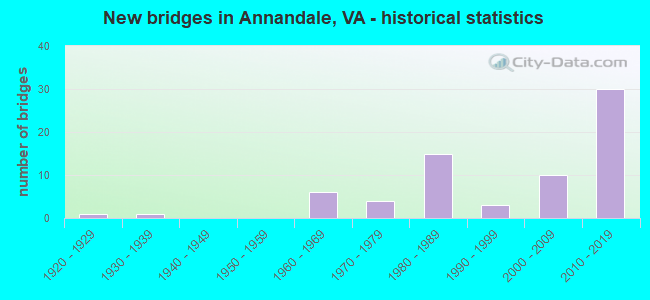
- New bridges - historical statistics
- 11920-1929
- 11930-1939
- 61960-1969
- 41970-1979
- 151980-1989
- 31990-1999
- 102000-2009
- 302010-2019
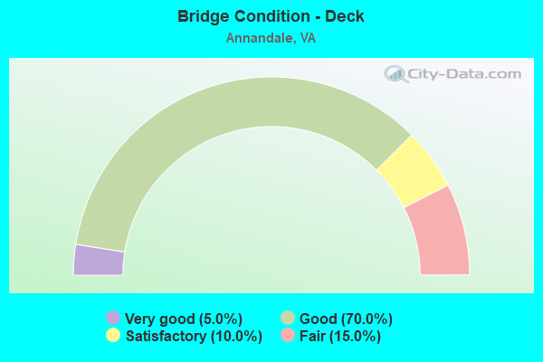
- Bridge Condition - Deck
- 5.0%Very good
- 70.0%Good
- 10.0%Satisfactory
- 15.0%Fair
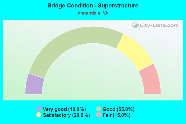
- Bridge Condition - Superstructure
- 10.0%Very good
- 55.0%Good
- 20.0%Satisfactory
- 15.0%Fair
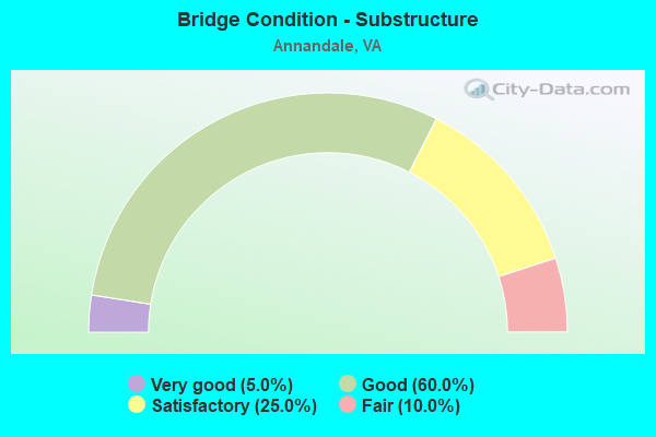
- Bridge Condition - Substructure
- 5.0%Very good
- 60.0%Good
- 25.0%Satisfactory
- 10.0%Fair
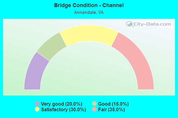
- Bridge Condition - Channel
- 20.0%Very good
- 15.0%Good
- 30.0%Satisfactory
- 35.0%Fair
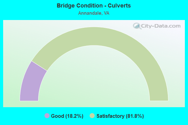
- Bridge Condition - Culverts
- 18.2%Good
- 81.8%Satisfactory
Find on map >> Show street view
Structure Number: 28669, Location: 0.76FR650 / 1.33TO66 (Lat: 38.865472, Lng: -77.219714), Route carried "under" structure: Ramp US 50, Year Built: 2009, Structure Length: 0. m, Average Daily Traffic: 12,000 (year 2009), Truck Traffic: 1%, Features Intersected: RTE.50, Facility Carried by Structure: RAMPS ASCN; AWN
Minimum Vertical Clearance: 5.26m (17.26ft), Kilometerpoint: 0.000, Lanes on structure: 2, Lanes under structure: 1, Material/Design: Prestressed concrete, Design/Construction: Stringer/Multi-beam, Length of Maximum Span: 29.4m (96.5ft)
Find on map >> Show street view
Structure Number: 28669, Location: 0.76FR650 / 1.33TO66 (Lat: 38.865472, Lng: -77.219714), Route carried "under" structure: US 50, Year Built: 2009, Structure Length: 0. m, Average Daily Traffic: 45,000 (year 2009), Truck Traffic: 5%, Features Intersected: RTE.50, Facility Carried by Structure: RAMPS ASCN; AWN
Minimum Vertical Clearance: 5.21m (17.09ft), Kilometerpoint: 0.000, Lanes on structure: 2, Lanes under structure: 4, Material/Design: Prestressed concrete, Design/Construction: Stringer/Multi-beam, Length of Maximum Span: 29.4m (96.5ft)
Find on map >> Show street view
Structure Number: 28669, Location: 0.76FR650 / 1.33TO66 (Lat: 38.865472, Lng: -77.219714), Route carried "under" structure: US 50, Year Built: 2009, Structure Length: 0. m, Average Daily Traffic: 43,000 (year 2009), Truck Traffic: 4%, Features Intersected: RTE.50, Facility Carried by Structure: RAMPS ASCN; AWN
Minimum Vertical Clearance: 5.46m (17.91ft), Kilometerpoint: 0.000, Lanes on structure: 2, Lanes under structure: 4, Material/Design: Prestressed concrete, Design/Construction: Stringer/Multi-beam, Length of Maximum Span: 29.4m (96.5ft)
Find on map >> Show street view
Structure Number: 28669, Location: 0.76FR650 / 1.33TO66 (Lat: 38.865472, Lng: -77.219714), Route carried "under" structure: Ramp US 50, Year Built: 2009, Structure Length: 0. m, Average Daily Traffic: 15,000 (year 2009), Truck Traffic: 2%, Features Intersected: RTE.50, Facility Carried by Structure: RAMPS ASCN; AWN
Minimum Vertical Clearance: 5.66m (18.57ft), Kilometerpoint: 0.000, Lanes on structure: 2, Lanes under structure: 1, Material/Design: Prestressed concrete, Design/Construction: Stringer/Multi-beam, Length of Maximum Span: 29.4m (96.5ft)
Find on map >> Show street view
Structure Number: 2867, Location: 00.83FR0650/01.29TO0066 (Lat: 38.865531, Lng: -77.219931), Route carried "under" structure: Ramp US 50, Year Built: 2010, Structure Length: 0. m, Average Daily Traffic: 30,000 (year 2010), Truck Traffic: 1%, Features Intersected: RTE.50, Facility Carried by Structure: I-495 NBL
Minimum Vertical Clearance: 5.59m (18.34ft), Kilometerpoint: 0.000, Lanes on structure: 6, Lanes under structure: 2, Material/Design: Prestressed concrete, Design/Construction: Stringer/Multi-beam, Length of Maximum Span: 28.2m (92.5ft)
Find on map >> Show street view
Structure Number: 2867, Location: 00.83FR0650/01.29TO0066 (Lat: 38.865531, Lng: -77.219931), Route carried "under" structure: US 50, Year Built: 2010, Structure Length: 0. m, Average Daily Traffic: 120,000 (year 2010), Truck Traffic: 1%, Features Intersected: RTE.50, Facility Carried by Structure: I-495 NBL
Minimum Vertical Clearance: 5.39m (17.68ft), Kilometerpoint: 0.000, Lanes on structure: 6, Lanes under structure: 4, Material/Design: Prestressed concrete, Design/Construction: Stringer/Multi-beam, Length of Maximum Span: 28.2m (92.5ft)
Find on map >> Show street view
Structure Number: 2867, Location: 00.83FR0650/01.29TO0066 (Lat: 38.865531, Lng: -77.219931), Route carried "under" structure: US 50, Year Built: 2010, Structure Length: 0. m, Average Daily Traffic: 120,000 (year 2010), Truck Traffic: 1%, Features Intersected: RTE.50, Facility Carried by Structure: I-495 NBL
Minimum Vertical Clearance: 5.16m (16.93ft), Kilometerpoint: 0.000, Lanes on structure: 6, Lanes under structure: 4, Material/Design: Prestressed concrete, Design/Construction: Stringer/Multi-beam, Length of Maximum Span: 28.2m (92.5ft)
Find on map >> Show street view
Structure Number: 2867, Location: 00.83FR0650/01.29TO0066 (Lat: 38.865531, Lng: -77.219931), Route carried "under" structure: Ramp US 50, Year Built: 2010, Structure Length: 0. m, Average Daily Traffic: 30,000 (year 2010), Truck Traffic: 1%, Features Intersected: RTE.50, Facility Carried by Structure: I-495 NBL
Minimum Vertical Clearance: 5.26m (17.26ft), Kilometerpoint: 0.000, Lanes on structure: 6, Lanes under structure: 1, Material/Design: Prestressed concrete, Design/Construction: Stringer/Multi-beam, Length of Maximum Span: 28.2m (92.5ft)
Find on map >> Show street view
Structure Number: 28672, Location: 00.83FR650/01.29TO66 (Lat: 38.865494, Lng: -77.220622), Route carried "under" structure: Ramp US 50, Year Built: 2009, Structure Length: 0. m, Average Daily Traffic: 12,000 (year 2009), Truck Traffic: 1%, Features Intersected: ROUTE 50, Facility Carried by Structure: RAMPS ACNS;AES;ANE
Minimum Vertical Clearance: 5.89m (19.32ft), Kilometerpoint: 0.000, Lanes on structure: 2, Lanes under structure: 1, Material/Design: Concrete, Design/Construction: Stringer/Multi-beam, Length of Maximum Span: 28.2m (92.5ft)
Find on map >> Show street view
Structure Number: 28672, Location: 00.83FR650/01.29TO66 (Lat: 38.865494, Lng: -77.220622), Route carried "under" structure: US 50, Year Built: 2009, Structure Length: 0. m, Average Daily Traffic: 45,000 (year 2009), Truck Traffic: 1%, Features Intersected: ROUTE 50, Facility Carried by Structure: RAMPS ACNS;AES;ANE
Minimum Vertical Clearance: 5.66m (18.57ft), Kilometerpoint: 0.000, Lanes on structure: 2, Lanes under structure: 4, Material/Design: Concrete, Design/Construction: Stringer/Multi-beam, Length of Maximum Span: 28.2m (92.5ft)
Find on map >> Show street view
Structure Number: 28672, Location: 00.83FR650/01.29TO66 (Lat: 38.865494, Lng: -77.220622), Route carried "under" structure: Ramp US 50, Year Built: 2009, Structure Length: 0. m, Average Daily Traffic: 12,000 (year 2009), Truck Traffic: 1%, Features Intersected: ROUTE 50, Facility Carried by Structure: RAMPS ACNS;AES;ANE
Minimum Vertical Clearance: 5.23m (17.16ft), Kilometerpoint: 0.000, Lanes on structure: 2, Lanes under structure: 1, Material/Design: Concrete, Design/Construction: Stringer/Multi-beam, Length of Maximum Span: 28.2m (92.5ft)
Find on map >> Show street view
Structure Number: 28672, Location: 00.83FR650/01.29TO66 (Lat: 38.865494, Lng: -77.220622), Route carried "under" structure: US 50, Year Built: 2009, Structure Length: 0. m, Average Daily Traffic: 45,000 (year 2009), Truck Traffic: 1%, Features Intersected: ROUTE 50, Facility Carried by Structure: RAMPS ACNS;AES;ANE
Minimum Vertical Clearance: 5.23m (17.16ft), Kilometerpoint: 0.000, Lanes on structure: 2, Lanes under structure: 4, Material/Design: Concrete, Design/Construction: Stringer/Multi-beam, Length of Maximum Span: 28.2m (92.5ft)
Find on map >> Show street view
Structure Number: 28693, Location: 00.92FR71/ 00.70TO Ravens (Lat: 38.811389, Lng: -77.218461), Route carried "under" structure: Interstate 495, Year Built: 2010, Structure Length: 0. m, Average Daily Traffic: 148,680 (year 2010), Truck Traffic: 15%, Features Intersected: I-495, Facility Carried by Structure: 620 BRADDOCK RD.
Minimum Vertical Clearance: 5.69m (18.67ft), Kilometerpoint: 0.000, Lanes on structure: 8, Lanes under structure: 6, Material/Design: Steel continuous, Design/Construction: Stringer/Multi-beam, Length of Maximum Span: 47.4m (155.5ft)
Find on map >> Show street view
Structure Number: 28693, Location: 00.92FR71/ 00.70TO Ravens (Lat: 38.811389, Lng: -77.218461), Route carried "under" structure: Ramp Interstate 495, Year Built: 2010, Structure Length: 0. m, Average Daily Traffic: 52,000 (year 2010), Truck Traffic: 8%, Features Intersected: I-495, Facility Carried by Structure: 620 BRADDOCK RD.
Minimum Vertical Clearance: 6.43m (21.10ft), Kilometerpoint: 0.000, Lanes on structure: 8, Lanes under structure: 2, Material/Design: Steel continuous, Design/Construction: Stringer/Multi-beam, Length of Maximum Span: 47.4m (155.5ft)
Find on map >> Show street view
Structure Number: 28693, Location: 00.92FR71/ 00.70TO Ravens (Lat: 38.811389, Lng: -77.218461), Route carried "under" structure: Ramp Interstate 495, Year Built: 2010, Structure Length: 0. m, Average Daily Traffic: 45,000 (year 2010), Truck Traffic: 7%, Features Intersected: I-495, Facility Carried by Structure: 620 BRADDOCK RD.
Minimum Vertical Clearance: 5.49m (18.01ft), Kilometerpoint: 0.000, Lanes on structure: 8, Lanes under structure: 1, Material/Design: Steel continuous, Design/Construction: Stringer/Multi-beam, Length of Maximum Span: 47.4m (155.5ft)
Find on map >> Show street view
Structure Number: 28693, Location: 00.92FR71/ 00.70TO Ravens (Lat: 38.811389, Lng: -77.218461), Route carried "under" structure: Interstate 495, Year Built: 2010, Structure Length: 0. m, Average Daily Traffic: 152,600 (year 2010), Truck Traffic: 15%, Features Intersected: I-495, Facility Carried by Structure: 620 BRADDOCK RD.
Minimum Vertical Clearance: 6.22m (20.41ft), Kilometerpoint: 0.000, Lanes on structure: 8, Lanes under structure: 6, Material/Design: Steel continuous, Design/Construction: Stringer/Multi-beam, Length of Maximum Span: 47.4m (155.5ft)
Find on map >> Show street view
Structure Number: 29186, Location: .01FR 620 TO.2 495NB (Lat: 38.812833, Lng: -77.219306), Route carried "under" structure: Interstate 495, Year Built: 2012, Structure Length: 0. m, Average Daily Traffic: 30,000 (year 2012), Truck Traffic: 4%, Features Intersected: I-495 SB and HOT lanes, Facility Carried by Structure: RAMPS BNEWH &BEWNH
Minimum Vertical Clearance: 7.11m (23.33ft), Kilometerpoint: 0.000, Lanes on structure: 2, Lanes under structure: 6, Toll: On toll road, Material/Design: Concrete, Design/Construction: Slab, Length of Maximum Span: 45.7m (149.9ft)
Find on map >> Show street view
Structure Number: 29186, Location: .01FR 620 TO.2 495NB (Lat: 38.812833, Lng: -77.219306), Route carried "under" structure: Ramp State highway 495, Year Built: 2012, Structure Length: 0. m, Average Daily Traffic: 15,000 (year 2012), Truck Traffic: 4%, Features Intersected: I-495 SB and HOT lanes, Facility Carried by Structure: RAMPS BNEWH &BEWNH
Minimum Vertical Clearance: 5.39m (17.68ft), Kilometerpoint: 0.000, Lanes on structure: 2, Lanes under structure: 1, Material/Design: Concrete, Design/Construction: Slab, Length of Maximum Span: 45.7m (149.9ft)