Bridge Statistics for Arlington Heights, Pennsylvania (PA)
Condition, Traffic, Stress, Structural Evaluation, Project Costs
- National Bridge Inventory (NBI) Statistics
- 54Number of bridges
- 335ft / 102mTotal length
- $3,739,000Total costs
- 579,941Total average daily traffic
- 101,252Total average daily truck traffic
- National Bridge Inventory (NBI) Registered Bridges for Arlington Heights
- No street view available for this location
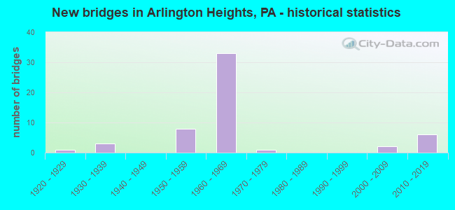
- New bridges - historical statistics
- 11920-1929
- 31930-1939
- 81950-1959
- 331960-1969
- 11970-1979
- 22000-2009
- 62010-2019
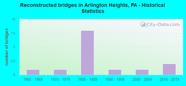
- Reconstructed bridges - Historical Statistics
- 11960-1969
- 11970-1979
- 81980-1989
- 11990-1999
- 12000-2009
- 22010-2019
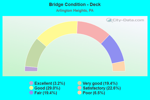
- Bridge Condition - Deck
- 3.2%Excellent
- 19.4%Very good
- 29.0%Good
- 22.6%Satisfactory
- 19.4%Fair
- 6.5%Poor
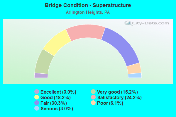
- Bridge Condition - Superstructure
- 3.0%Excellent
- 15.2%Very good
- 18.2%Good
- 24.2%Satisfactory
- 30.3%Fair
- 6.1%Poor
- 3.0%Serious
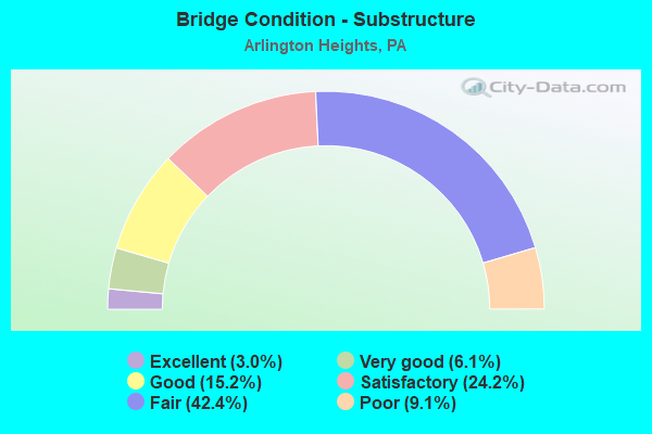
- Bridge Condition - Substructure
- 3.0%Excellent
- 6.1%Very good
- 15.2%Good
- 24.2%Satisfactory
- 42.4%Fair
- 9.1%Poor
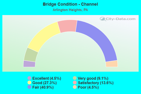
- Bridge Condition - Channel
- 4.5%Excellent
- 9.1%Very good
- 27.3%Good
- 13.6%Satisfactory
- 40.9%Fair
- 4.5%Poor
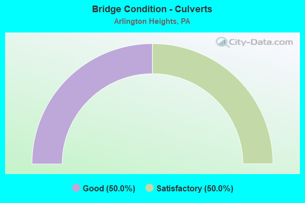
- Bridge Condition - Culverts
- 50.0%Good
- 50.0%Satisfactory
Find on map >> Show street view
Structure Number: 26672, Location: 7.9 MI.N.OF ROSS COMMON (Lat: 40.959375, Lng: -75.284278), Route carried "on" structure: State highway 33, Year Built: 1963, Year Reconstructed: 1997, Status: Open, Structure Length: 2.04m (6.69ft), Average Daily Traffic: 10,116 (year 2020), Truck Traffic: 18%, Average Future Daily Traffic: 12,895 (year 2032), Design Load: HS 20, Features Intersected: US 209 (LR 164 ALT) SB
Minimum Vertical Clearance: 30+ m (98+ ft), Kilometerpoint: 9.040, Lanes on structure: 2, Lanes under structure: 2, Base Highway Network: Yes, Owner: State Highway Agency, Approaching Roadway Width: 12.8m (42.0ft), Skew: 4 degrees, Material/Design: Prestressed concrete, Design/Construction: Stringer/Multi-beam, Number Of Spans In Main Unit: 1, Length of Maximum Span: 19.8m (65.0ft), Curb or Sidewalk Widths: Left: 0.2m (0.7ft), Right: 0.2m (0.7ft), Curb-To-Curb Width: 11.6m (38.1ft), Out-to-Out Width: 13.3m (43.6ft)
Condition: Deck: Good, Superstructure: Fair, Substructure: Fair, Operating Rating: 88.9 metric tons, Method Used To Determine Operating Rating: Load Factor (LF), Inventory Rating: 33.6 metric tons, Method Used To Determine Inventory Rating: Load Factor (LF), Structural Evaluation: Somewhat better than minimum adequacy, Deck Geometry: Better than present minimum criteria, Underclear: High priority of corrective action, Approach Roadway Alignment: Better than present minimum criteria, Length Of Structure Improvement: 2.70m (8.86ft), Designated Inspection Frequency: Every 24 months, Inspection Date: June 2021, Bridge Improvement Cost: $15,000, Roadway Improvement Cost: $43,000, Total Project Cost: $197,000, Deck Structure Type: Concrete Cast-file-Place, Wearing Surface/Protective System: Wearing Surface: Monolithic Concrete, Deck Protection: Epoxy Coated Reinforcing
Find on map >> Show street view
Structure Number: 26673, Location: 1.3 MI.S.OF I-80 (Lat: 40.980400, Lng: -75.273775), Route carried "on" structure: State highway , Year Built: 1963, Status: Posted for load, Structure Length: 2.77m (9.09ft), Average Daily Traffic: 699 (year 2021), Truck Traffic: 6%, Average Future Daily Traffic: 934 (year 2032), Design Load: HS 20, Features Intersected: PA 33 (LR 796), Facility Carried by Structure: SR2036 SHIFFERS RD
Minimum Vertical Clearance: 30+ m (98+ ft), Kilometerpoint: 0.000, Lanes on structure: 2, Lanes under structure: 8, Owner: State Highway Agency, Approaching Roadway Width: 5.8m (19.0ft), Material/Design: Steel, Design/Construction: Stringer/Multi-beam, Number Of Spans In Main Unit: 1, Length of Maximum Span: 26.2m (86.0ft), Curb or Sidewalk Widths: Left: 0.5m (1.6ft), Right: 0.5m (1.6ft), Curb-To-Curb Width: 8.5m (27.9ft), Out-to-Out Width: 10.2m (33.5ft)
Condition: Deck: Poor, Superstructure: Serious, Substructure: Satisfactory, Operating Rating: 13.6 metric tons, Method Used To Determine Operating Rating: Field evaluation and documented engineering judgment, Inventory Rating: 9.1 metric tons, Method Used To Determine Inventory Rating: Field evaluation and documented engineering judgment, Structural Evaluation: High priority of replacement, Deck Geometry: Somewhat better than minimum adequacy, Underclear: Meets minimum limits, Approach Roadway Alignment: Better than present minimum criteria, Bridge Posting: Required (Relationship of Operating Rating to Maximum Legal Load: > 39.9% below), Length Of Structure Improvement: 3.50m (11.48ft), Designated Inspection Frequency: Every 24 months, Other Special Inspection Frequency: Every 12 months, Inspection Date: June 2020, Other Special Inspection Date: June 2021, Bridge Improvement Cost: $9,000, Roadway Improvement Cost: $25,000, Total Project Cost: $116,000, Deck Structure Type: Concrete Cast-file-Place, Wearing Surface/Protective System: Wearing Surface: Monolithic Concrete
Find on map >> Show street view
Structure Number: 26677, Location: PA 33 NB OVER I-80 (Lat: 40.997578, Lng: -75.269314), Route carried "on" structure: State highway 33, Year Built: 1963, Year Reconstructed: 1992, Status: Open, Structure Length: 4.79m (15.72ft), Average Daily Traffic: 14,482 (year 2020), Truck Traffic: 16%, Average Future Daily Traffic: 10,933 (year 2032), Design Load: HS 20, Features Intersected: I-80(LR 1002)
Minimum Vertical Clearance: 30+ m (98+ ft), Kilometerpoint: 13.655, Lanes on structure: 2, Lanes under structure: 8, Base Highway Network: Yes, Owner: State Highway Agency, Approaching Roadway Width: 11.3m (37.1ft), Skew: 12 degrees, Material/Design: Prestressed concrete, Design/Construction: Box Beam or Girders - Multiple, Number Of Spans In Main Unit: 2, Length of Maximum Span: 24.1m (79.1ft), Curb or Sidewalk Widths: Left: 0.2m (0.7ft), Right: 0.2m (0.7ft), Curb-To-Curb Width: 12.6m (41.3ft), Out-to-Out Width: 13.7m (44.9ft)
Condition: Deck: Good, Superstructure: Fair, Substructure: Fair, Operating Rating: 86.2 metric tons, Method Used To Determine Operating Rating: Load Factor (LF), Inventory Rating: 44.5 metric tons, Method Used To Determine Inventory Rating: Load Factor (LF), Structural Evaluation: Somewhat better than minimum adequacy, Deck Geometry: Better than present minimum criteria, Underclear: Meets minimum limits, Approach Roadway Alignment: Equal to present desirable criteria, Length Of Structure Improvement: 5.70m (18.70ft), Designated Inspection Frequency: Every 24 months, Inspection Date: May 2020, Deck Structure Type: Concrete Cast-file-Place, Wearing Surface/Protective System: Wearing Surface: Monolithic Concrete, Deck Protection: Epoxy Coated Reinforcing
Find on map >> Show street view
Structure Number: 26719, Location: OVER SCHAEFER SCHOOLHOUSE (Lat: 40.993150, Lng: -75.255694), Route carried "on" structure: Interstate 80, Year Built: 1963, Year Reconstructed: 1992, Status: Open, Structure Length: 1.25m (4.10ft), Average Daily Traffic: 23,946 (year 2021), Truck Traffic: 30%, Average Future Daily Traffic: 30,961 (year 2032), Design Load: HS 25 or greater, Features Intersected: SR 2005 (LR 45019)
Minimum Vertical Clearance: 30+ m (98+ ft), Kilometerpoint: 32.428, Lanes on structure: 2, Lanes under structure: 2, Base Highway Network: Yes, Owner: State Highway Agency, Approaching Roadway Width: 12.8m (42.0ft), Skew: 13 degrees, Material/Design: Prestressed concrete, Design/Construction: Box Beam or Girders - Single/Spread, Number Of Spans In Main Unit: 1, Length of Maximum Span: 11.9m (39.0ft), Curb or Sidewalk Widths: Left: 0.2m (0.7ft), Right: 0.2m (0.7ft), Curb-To-Curb Width: 12.8m (42.0ft), Out-to-Out Width: 13.9m (45.6ft)
Condition: Deck: Good, Superstructure: Good, Substructure: Poor, Operating Rating: 51.7 metric tons, Method Used To Determine Operating Rating: Load Factor (LF), Inventory Rating: 30.8 metric tons, Method Used To Determine Inventory Rating: Load Factor (LF), Structural Evaluation: Meets minimum limits, Deck Geometry: Equal to present desirable criteria, Underclear: Meets minimum limits, Approach Roadway Alignment: Equal to present desirable criteria, Length Of Structure Improvement: 1.90m (6.23ft), Designated Inspection Frequency: Every 24 months, Other Special Inspection Frequency: Every 6 months, Inspection Date: May 2020, Other Special Inspection Date: May 2021, Deck Structure Type: Concrete Cast-file-Place, Wearing Surface/Protective System: Wearing Surface: Monolithic Concrete, Deck Protection: Epoxy Coated Reinforcing
Find on map >> Show street view
Structure Number: 26721, Location: OVER SHAFERS SCHOOLHOUSE (Lat: 40.993461, Lng: -75.255808), Route carried "on" structure: Interstate 80, Year Built: 1963, Year Reconstructed: 1992, Status: Open, Structure Length: 1.25m (4.10ft), Average Daily Traffic: 23,479 (year 2021), Truck Traffic: 29%, Average Future Daily Traffic: 32,523 (year 2032), Design Load: HS 25 or greater, Features Intersected: SR 2005(LR 45019)
Minimum Vertical Clearance: 30+ m (98+ ft), Kilometerpoint: 32.646, Lanes on structure: 2, Lanes under structure: 2, Base Highway Network: Yes, Owner: State Highway Agency, Approaching Roadway Width: 12.8m (42.0ft), Skew: 13 degrees, Material/Design: Prestressed concrete, Design/Construction: Box Beam or Girders - Single/Spread, Number Of Spans In Main Unit: 1, Length of Maximum Span: 11.9m (39.0ft), Curb or Sidewalk Widths: Left: 0.2m (0.7ft), Right: 0.2m (0.7ft), Curb-To-Curb Width: 12.8m (42.0ft), Out-to-Out Width: 13.9m (45.6ft)
Condition: Deck: Satisfactory, Superstructure: Satisfactory, Substructure: Fair, Operating Rating: 51.7 metric tons, Method Used To Determine Operating Rating: Load Factor (LF), Inventory Rating: 30.8 metric tons, Method Used To Determine Inventory Rating: Load Factor (LF), Structural Evaluation: Somewhat better than minimum adequacy, Deck Geometry: Equal to present desirable criteria, Underclear: Meets minimum limits, Approach Roadway Alignment: Equal to present desirable criteria, Length Of Structure Improvement: 1.90m (6.23ft), Designated Inspection Frequency: Every 24 months, Other Special Inspection Frequency: Every 12 months, Inspection Date: May 2020, Other Special Inspection Date: May 2021, Deck Structure Type: Concrete Cast-file-Place, Wearing Surface/Protective System: Wearing Surface: Monolithic Concrete, Deck Protection: Epoxy Coated Reinforcing
Find on map >> Show street view
Structure Number: 26722, Location: 1.5 MI.E.OF PA.33 (Lat: 40.989222, Lng: -75.243372), Route carried "on" structure: Interstate 80, Year Built: 1963, Year Reconstructed: 1992, Status: Open, Structure Length: 1.13m (3.71ft), Average Daily Traffic: 23,946 (year 2021), Truck Traffic: 30%, Average Future Daily Traffic: 30,961 (year 2032), Design Load: HS 25 or greater, Features Intersected: TWP. RD 498*
Minimum Vertical Clearance: 30+ m (98+ ft), Kilometerpoint: 33.233, Lanes on structure: 2, Lanes under structure: 2, Base Highway Network: Yes, Owner: State Highway Agency, Approaching Roadway Width: 12.8m (42.0ft), Skew: 12 degrees, Material/Design: Prestressed concrete, Design/Construction: Box Beam or Girders - Single/Spread, Number Of Spans In Main Unit: 1, Length of Maximum Span: 10.4m (34.1ft), Curb or Sidewalk Widths: Left: 0.2m (0.7ft), Right: 0.2m (0.7ft), Curb-To-Curb Width: 12.8m (42.0ft), Out-to-Out Width: 13.9m (45.6ft)
Condition: Deck: Good, Superstructure: Good, Substructure: Fair, Operating Rating: 50.8 metric tons, Method Used To Determine Operating Rating: Load Factor (LF), Inventory Rating: 29.9 metric tons, Method Used To Determine Inventory Rating: Load Factor (LF), Structural Evaluation: Somewhat better than minimum adequacy, Deck Geometry: Equal to present desirable criteria, Underclear: Meets minimum limits, Approach Roadway Alignment: Equal to present desirable criteria, Length Of Structure Improvement: 1.70m (5.58ft), Designated Inspection Frequency: Every 24 months, Inspection Date: June 2020, Deck Structure Type: Concrete Cast-file-Place, Wearing Surface/Protective System: Wearing Surface: Monolithic Concrete, Deck Protection: Epoxy Coated Reinforcing
Find on map >> Show street view
Structure Number: 26724, Location: 1.5 MI.E.OF PA.33 (Lat: 40.989514, Lng: -75.243453), Route carried "on" structure: Interstate 80, Year Built: 1963, Year Reconstructed: 1991, Status: Open, Structure Length: 1.13m (3.71ft), Average Daily Traffic: 23,479 (year 2021), Truck Traffic: 29%, Average Future Daily Traffic: 32,523 (year 2032), Design Load: HS 25 or greater, Features Intersected: TWP.RD 498
Minimum Vertical Clearance: 30+ m (98+ ft), Kilometerpoint: 33.450, Lanes on structure: 2, Lanes under structure: 2, Base Highway Network: Yes, Owner: State Highway Agency, Approaching Roadway Width: 12.8m (42.0ft), Skew: 12 degrees, Material/Design: Prestressed concrete, Design/Construction: Box Beam or Girders - Single/Spread, Number Of Spans In Main Unit: 1, Length of Maximum Span: 10.4m (34.1ft), Curb or Sidewalk Widths: Left: 0.2m (0.7ft), Right: 0.2m (0.7ft), Curb-To-Curb Width: 12.8m (42.0ft), Out-to-Out Width: 13.9m (45.6ft)
Condition: Deck: Good, Superstructure: Good, Substructure: Fair, Operating Rating: 50.8 metric tons, Method Used To Determine Operating Rating: Load Factor (LF), Inventory Rating: 29.9 metric tons, Method Used To Determine Inventory Rating: Load Factor (LF), Structural Evaluation: Somewhat better than minimum adequacy, Deck Geometry: Equal to present desirable criteria, Underclear: Meets minimum limits, Approach Roadway Alignment: Equal to present desirable criteria, Length Of Structure Improvement: 1.70m (5.58ft), Designated Inspection Frequency: Every 24 months, Inspection Date: June 2020, Deck Structure Type: Concrete Cast-file-Place, Wearing Surface/Protective System: Wearing Surface: Monolithic Concrete, Deck Protection: Epoxy Coated Reinforcing
Find on map >> Show street view
Structure Number: 26725, Location: OVER SR 2009(BRIDGE ST) (Lat: 40.985386, Lng: -75.225789), Route carried "on" structure: Interstate 80, Year Built: 1959, Year Reconstructed: 1986, Status: Open, Structure Length: 10.06m (33.01ft), Average Daily Traffic: 51,937 (year 2022), Truck Traffic: 22%, Average Future Daily Traffic: 63,484 (year 2032), Design Load: HS 20+Mod, Features Intersected: SR 2009,POCONO CR.
Minimum Vertical Clearance: 30+ m (98+ ft), Kilometerpoint: 34.846, Lanes on structure: 4, Lanes under structure: 2, Base Highway Network: Yes, Owner: State Highway Agency, Approaching Roadway Width: 23.2m (76.1ft), Skew: 39 degrees, Material/Design: Steel continuous, Design/Construction: Stringer/Multi-beam, Number Of Spans In Main Unit: 3, Number Of Approach Spans: 1, Length of Maximum Span: 30.8m (101.0ft), Curb-To-Curb Width: 17.6m (57.7ft), Out-to-Out Width: 20.0m (65.6ft)
Condition: Deck: Satisfactory, Superstructure: Satisfactory, Substructure: Fair, Channel: Fair, Operating Rating: 59.0 metric tons, Method Used To Determine Operating Rating: Load Factor (LF), Inventory Rating: 35.4 metric tons, Method Used To Determine Inventory Rating: Load Factor (LF), Structural Evaluation: Somewhat better than minimum adequacy, Deck Geometry: Meets minimum limits, Underclear: Meets minimum limits, Waterway Adequacy: Superior to present desirable criteria, Approach Roadway Alignment: Equal to present desirable criteria, Length Of Structure Improvement: 11.00m (36.09ft), Designated Inspection Frequency: Every 24 months, Inspection Date: April 2021, Deck Structure Type: Concrete Cast-file-Place, Wearing Surface/Protective System: Wearing Surface: Monolithic Concrete, Deck Protection: Epoxy Coated Reinforcing
Find on map >> Show street view
Structure Number: 26767, Location: AT PINEBROOK PARK (Lat: 41.034689, Lng: -75.210797), Route carried "on" structure: State highway 191, Year Built: 1958, Status: Open, Structure Length: 1.49m (4.89ft), Average Daily Traffic: 5,189 (year 2022), Truck Traffic: 3%, Average Future Daily Traffic: 9,381 (year 2032), Design Load: HS 20, Features Intersected: BRODHEAD CK.OLD CHANNEL
Minimum Vertical Clearance: 30+ m (98+ ft), Kilometerpoint: 12.110, Lanes on structure: 2, Owner: State Highway Agency, Approaching Roadway Width: 12.8m (42.0ft), Skew: 4 degrees, Material/Design: Prestressed concrete, Design/Construction: Box Beam or Girders - Multiple, Number Of Spans In Main Unit: 1, Length of Maximum Span: 14.6m (47.9ft)
Condition: Superstructure: Fair, Substructure: Satisfactory, Channel: Fair, Operating Rating: 77.1 metric tons, Method Used To Determine Operating Rating: Load Factor (LF), Inventory Rating: 46.3 metric tons, Method Used To Determine Inventory Rating: Load Factor (LF), Structural Evaluation: Somewhat better than minimum adequacy, Waterway Adequacy: Equal to present minimum criteria, Approach Roadway Alignment: Equal to present desirable criteria, Length Of Structure Improvement: 2.20m (7.22ft), Designated Inspection Frequency: Every 24 months, Inspection Date: July 2021
Find on map >> Show street view
Structure Number: 26768, Location: @ JCT. WITH PA. 447 (Lat: 41.037114, Lng: -75.209856), Route carried "on" structure: State highway 191, Year Built: 1958, Status: Open, Structure Length: 10.09m (33.10ft), Average Daily Traffic: 5,189 (year 2022), Truck Traffic: 3%, Average Future Daily Traffic: 9,381 (year 2032), Design Load: HS 20, Features Intersected: BRODHEAD CK MONROE CO RA
Minimum Vertical Clearance: 30+ m (98+ ft), Kilometerpoint: 13.163, Lanes on structure: 2, Owner: State Highway Agency, Approaching Roadway Width: 12.8m (42.0ft), Material/Design: Steel, Design/Construction: Stringer/Multi-beam, Number Of Spans In Main Unit: 1, Number Of Approach Spans: 3, Length of Maximum Span: 46.9m (153.9ft), Curb or Sidewalk Widths: Left: 0.5m (1.6ft), Right: 0.5m (1.6ft), Curb-To-Curb Width: 9.1m (29.9ft), Out-to-Out Width: 10.8m (35.4ft)
Condition: Deck: Satisfactory, Superstructure: Good, Substructure: Satisfactory, Channel: Very good, Operating Rating: 87.1 metric tons, Method Used To Determine Operating Rating: Load Factor (LF), Inventory Rating: 52.6 metric tons, Method Used To Determine Inventory Rating: Load Factor (LF), Structural Evaluation: Equal to present minimum criteria, Deck Geometry: Meets minimum limits, Underclear: High priority of corrective action, Waterway Adequacy: Superior to present desirable criteria, Approach Roadway Alignment: Somewhat better than minimum adequacy, Length Of Structure Improvement: 11.00m (36.09ft), Designated Inspection Frequency: Every 24 months, Other Special Inspection Frequency: Every 6 months, Inspection Date: June 2020, Other Special Inspection Date: June 2021, Bridge Improvement Cost: $23,000, Roadway Improvement Cost: $67,000, Total Project Cost: $308,000, Deck Structure Type: Concrete Cast-file-Place, Wearing Surface/Protective System: Wearing Surface: Bituminous
Find on map >> Show street view
Structure Number: 26794, Location: .5M.N.OF SNYDERSVILLE EX. (Lat: 40.956114, Lng: -75.285950), Route carried "on" structure: US 209, Year Built: 1963, Year Reconstructed: 1978, Status: Open, Structure Length: 5.46m (17.91ft), Average Daily Traffic: 16,335 (year 2020), Truck Traffic: 15%, Average Future Daily Traffic: 27,654 (year 2032), Design Load: HS 20, Features Intersected: APPENZELL CREEK
Minimum Vertical Clearance: 30+ m (98+ ft), Kilometerpoint: 23.950, Lanes on structure: 3, Base Highway Network: Yes, Owner: State Highway Agency, Approaching Roadway Width: 15.2m (49.9ft), Skew: 14 degrees, Material/Design: Prestressed concrete, Design/Construction: Stringer/Multi-beam, Number Of Spans In Main Unit: 3, Length of Maximum Span: 20.4m (66.9ft), Curb-To-Curb Width: 15.1m (49.5ft), Out-to-Out Width: 16.3m (53.5ft)
Condition: Deck: Fair, Superstructure: Fair, Substructure: Poor, Channel: Fair, Operating Rating: 56.2 metric tons, Method Used To Determine Operating Rating: Load Factor (LF), Inventory Rating: 33.6 metric tons, Method Used To Determine Inventory Rating: Load Factor (LF), Structural Evaluation: Meets minimum limits, Deck Geometry: Meets minimum limits, Waterway Adequacy: Equal to present minimum criteria, Approach Roadway Alignment: Equal to present desirable criteria, Length Of Structure Improvement: 6.40m (21.00ft), Designated Inspection Frequency: Every 24 months, Inspection Date: May 2020, Deck Structure Type: Concrete Cast-file-Place, Wearing Surface/Protective System: Wearing Surface: Latex Concrete
Find on map >> Show street view
Structure Number: 26798, Location: US209 OVER HICKORY VALLEY (Lat: 40.970011, Lng: -75.258186), Route carried "on" structure: Alternate US 209, Year Built: 1963, Status: Open, Structure Length: 1.19m (3.90ft), Average Daily Traffic: 20,553 (year 2021), Truck Traffic: 8%, Average Future Daily Traffic: 28,795 (year 2032), Design Load: HS 20, Features Intersected: SR 2010(LR 45009)
Minimum Vertical Clearance: 30+ m (98+ ft), Kilometerpoint: 26.833, Lanes on structure: 4, Lanes under structure: 2, Base Highway Network: Yes, Owner: State Highway Agency, Approaching Roadway Width: 26.2m (86.0ft), Skew: 22 degrees, Material/Design: Prestressed concrete, Design/Construction: Stringer/Multi-beam, Number Of Spans In Main Unit: 1, Length of Maximum Span: 11.3m (37.1ft), Curb or Sidewalk Widths: Left: 0.5m (1.6ft), Right: 0.5m (1.6ft), Curb-To-Curb Width: 24.7m (81.0ft), Out-to-Out Width: 27.3m (89.6ft)
Condition: Deck: Good, Superstructure: Fair, Substructure: Fair, Operating Rating: 75.3 metric tons, Method Used To Determine Operating Rating: Load Factor (LF), Inventory Rating: 34.5 metric tons, Method Used To Determine Inventory Rating: Load Factor (LF), Structural Evaluation: Somewhat better than minimum adequacy, Deck Geometry: Superior to present desirable criteria, Underclear: Meets minimum limits, Approach Roadway Alignment: Equal to present desirable criteria, Length Of Structure Improvement: 1.80m (5.91ft), Designated Inspection Frequency: Every 24 months, Inspection Date: April 2021, Bridge Improvement Cost: $32,000, Roadway Improvement Cost: $94,000, Total Project Cost: $431,000, Deck Structure Type: Concrete Cast-file-Place, Wearing Surface/Protective System: Wearing Surface: Bituminous
Find on map >> Show street view
Structure Number: 26801, Location: US209 OVER 209 BUS. (Lat: 40.982708, Lng: -75.222128), Route carried "on" structure: US 209, Year Built: 1963, Status: Open, Structure Length: 1.40m (4.59ft), Average Daily Traffic: 18,415 (year 2022), Truck Traffic: 7%, Average Future Daily Traffic: 24,978 (year 2032), Design Load: HS 20, Features Intersected: SR2012(US 209 BUSINESS)
Minimum Vertical Clearance: 30+ m (98+ ft), Kilometerpoint: 30.059, Lanes on structure: 4, Lanes under structure: 2, Base Highway Network: Yes, Owner: State Highway Agency, Approaching Roadway Width: 24.1m (79.1ft), Skew: 20 degrees, Material/Design: Prestressed concrete, Design/Construction: Stringer/Multi-beam, Number Of Spans In Main Unit: 1, Length of Maximum Span: 13.1m (43.0ft), Curb or Sidewalk Widths: Left: 0.5m (1.6ft), Right: 0.5m (1.6ft), Curb-To-Curb Width: 23.9m (78.4ft), Out-to-Out Width: 28.0m (91.9ft)
Condition: Deck: Fair, Superstructure: Satisfactory, Substructure: Fair, Operating Rating: 67.1 metric tons, Method Used To Determine Operating Rating: Load Factor (LF), Inventory Rating: 29.9 metric tons, Method Used To Determine Inventory Rating: Load Factor (LF), Structural Evaluation: Somewhat better than minimum adequacy, Deck Geometry: Superior to present desirable criteria, Underclear: High priority of corrective action, Approach Roadway Alignment: Equal to present desirable criteria, Length Of Structure Improvement: 2.00m (6.56ft), Designated Inspection Frequency: Every 24 months, Inspection Date: September 2021, Bridge Improvement Cost: $50,000, Roadway Improvement Cost: $147,000, Total Project Cost: $673,000, Deck Structure Type: Concrete Cast-file-Place, Wearing Surface/Protective System: Wearing Surface: Monolithic Concrete
Find on map >> Show street view
Structure Number: 26849, Location: 2/10 MI.N.OF US 209 BUS. (Lat: 41.020119, Lng: -75.184253), Route carried "on" structure: State highway 447, Year Built: 1924, Status: Open, Structure Length: 1.13m (3.71ft), Average Daily Traffic: 14,950 (year 2021), Truck Traffic: 3%, Average Future Daily Traffic: 21,286 (year 2032), Design Load: HS 20, Features Intersected: SAMBO CREEK
Minimum Vertical Clearance: 30+ m (98+ ft), Kilometerpoint: 3.473, Lanes on structure: 2, Owner: State Highway Agency, Approaching Roadway Width: 7.3m (24.0ft), Skew: 3 degrees, Material/Design: Steel, Design/Construction: Stringer/Multi-beam, Number Of Spans In Main Unit: 1, Length of Maximum Span: 10.4m (34.1ft), Curb-To-Curb Width: 7.3m (24.0ft), Out-to-Out Width: 8.0m (26.2ft)
Condition: Deck: Fair, Superstructure: Fair, Substructure: Poor, Channel: Fair, Operating Rating: 59.0 metric tons, Method Used To Determine Operating Rating: Load Factor (LF), Inventory Rating: 35.4 metric tons, Method Used To Determine Inventory Rating: Load Factor (LF), Structural Evaluation: Meets minimum limits, Deck Geometry: High priority of replacement, Waterway Adequacy: Equal to present desirable criteria, Approach Roadway Alignment: Equal to present desirable criteria, Length Of Structure Improvement: 1.40m (4.59ft), Designated Inspection Frequency: Every 24 months, Inspection Date: Febuary 2021, Bridge Improvement Cost: $36,000, Roadway Improvement Cost: $147,000, Total Project Cost: $487,000, Deck Structure Type: Concrete Cast-file-Place, Wearing Surface/Protective System: Wearing Surface: Bituminous
Find on map >> Show street view
Structure Number: 2685, Location: NEAR INTER.OF PA 191 (Lat: 41.037203, Lng: -75.208111), Route carried "on" structure: State highway 447, Year Built: 1959, Status: Open, Structure Length: 0.64m (2.10ft), Average Daily Traffic: 7,030 (year 2022), Truck Traffic: 4%, Average Future Daily Traffic: 15,686 (year 2032), Design Load: HS 20, Features Intersected: TRIB.TO BRODHEAD CREEK
Minimum Vertical Clearance: 30+ m (98+ ft), Kilometerpoint: 5.937, Lanes on structure: 2, Owner: State Highway Agency, Approaching Roadway Width: 11.3m (37.1ft), Skew: 3 degrees, Material/Design: Concrete, Design/Construction: Culvert, Number Of Spans In Main Unit: 1, Length of Maximum Span: 6.4m (21.0ft)
Condition: Channel: Fair, Culverts: Satisfactory, Operating Rating: 89.8 metric tons, Method Used To Determine Operating Rating: Load Factor (LF), Inventory Rating: 89.8 metric tons, Method Used To Determine Inventory Rating: Load Factor (LF), Structural Evaluation: Equal to present minimum criteria, Waterway Adequacy: Superior to present desirable criteria, Approach Roadway Alignment: Equal to present desirable criteria, Length Of Structure Improvement: 1.20m (3.94ft), Designated Inspection Frequency: Every 24 months, Inspection Date: Febuary 2021
Find on map >> Show street view
Structure Number: 26867, Location: OVER I-80 WB ON RAMP (Lat: 40.986675, Lng: -75.231717), Route carried "on" structure: State highway 611, Year Built: 1963, Status: Open, Structure Length: 1.25m (4.10ft), Average Daily Traffic: 14,062 (year 2022), Truck Traffic: 2%, Average Future Daily Traffic: 22,155 (year 2032), Design Load: HS 20, Features Intersected: SR 8012 (LR 1002 RAMP B)
Minimum Vertical Clearance: 30+ m (98+ ft), Kilometerpoint: 11.689, Lanes on structure: 3, Lanes under structure: 1, Owner: State Highway Agency, Approaching Roadway Width: 15.5m (50.9ft), Skew: 3 degrees, Material/Design: Concrete, Design/Construction: Tee Beam, Number Of Spans In Main Unit: 1, Length of Maximum Span: 11.9m (39.0ft), Curb-To-Curb Width: 14.9m (48.9ft), Out-to-Out Width: 16.6m (54.5ft)
Condition: Deck: Satisfactory, Superstructure: Satisfactory, Substructure: Fair, Operating Rating: 53.5 metric tons, Method Used To Determine Operating Rating: Load Factor (LF), Inventory Rating: 31.8 metric tons, Method Used To Determine Inventory Rating: Load Factor (LF), Structural Evaluation: Somewhat better than minimum adequacy, Deck Geometry: Equal to present minimum criteria, Underclear: High priority of corrective action, Approach Roadway Alignment: Equal to present desirable criteria, Length Of Structure Improvement: 1.90m (6.23ft), Designated Inspection Frequency: Every 24 months, Inspection Date: April 2021, Bridge Improvement Cost: $8,000, Roadway Improvement Cost: $22,000, Total Project Cost: $102,000, Deck Structure Type: Concrete Cast-file-Place, Wearing Surface/Protective System: Wearing Surface: Bituminous
Find on map >> Show street view
Structure Number: 2692, Location: @ PINEBROOK & HALLET RDS. (Lat: 41.035372, Lng: -75.212314), Route carried "on" structure: State highway , Year Built: 1932, Status: Open, Structure Length: 4.79m (15.72ft), Average Daily Traffic: 3,588 (year 2022), Truck Traffic: 2%, Average Future Daily Traffic: 6,687 (year 2032), Design Load: HS 20, Features Intersected: CRANBERRY RUN, Facility Carried by Structure: SR 1003 (LR 45080)
Minimum Vertical Clearance: 30+ m (98+ ft), Kilometerpoint: 0.000, Lanes on structure: 2, Owner: State Highway Agency, Approaching Roadway Width: 6.7m (22.0ft), Material/Design: Steel, Design/Construction: Stringer/Multi-beam, Number Of Spans In Main Unit: 2, Length of Maximum Span: 23.8m (78.1ft), Curb-To-Curb Width: 6.7m (22.0ft), Out-to-Out Width: 7.2m (23.6ft)
Condition: Deck: Fair, Superstructure: Fair, Substructure: Fair, Channel: Satisfactory, Operating Rating: 40.8 metric tons, Method Used To Determine Operating Rating: Load Factor (LF), Inventory Rating: 24.5 metric tons, Method Used To Determine Inventory Rating: Load Factor (LF), Structural Evaluation: Somewhat better than minimum adequacy, Deck Geometry: High priority of replacement, Waterway Adequacy: Better than present minimum criteria, Approach Roadway Alignment: Meets minimum limits, Length Of Structure Improvement: 5.70m (18.70ft), Designated Inspection Frequency: Every 24 months, Inspection Date: April 2020, Bridge Improvement Cost: $31,000, Roadway Improvement Cost: $92,000, Total Project Cost: $420,000, Deck Structure Type: Open Grating
Find on map >> Show street view
Structure Number: 26925, Location: 1.3 M. N.OF PA 191 (Lat: 41.062200, Lng: -75.198153), Route carried "on" structure: State highway , Year Built: 1932, Year Reconstructed: 2014, Status: Open, Structure Length: 0.70m (2.30ft), Average Daily Traffic: 100 (year 2019), Truck Traffic: 14%, Average Future Daily Traffic: 140 (year 2032), Design Load: HS 20, Features Intersected: MICHAEL CREEK, Facility Carried by Structure: SR 1005(LR 45018)
Minimum Vertical Clearance: 30+ m (98+ ft), Kilometerpoint: 1.642, Lanes on structure: 2, Owner: State Highway Agency, Approaching Roadway Width: 7.6m (24.9ft), Skew: 3 degrees, Material/Design: Steel, Design/Construction: Stringer/Multi-beam, Number Of Spans In Main Unit: 1, Length of Maximum Span: 6.4m (21.0ft), Curb-To-Curb Width: 7.5m (24.6ft), Out-to-Out Width: 7.5m (24.6ft)
Condition: Deck: Very good, Superstructure: Good, Substructure: Satisfactory, Channel: Fair, Operating Rating: 86.2 metric tons, Method Used To Determine Operating Rating: Load Factor (LF), Inventory Rating: 51.7 metric tons, Method Used To Determine Inventory Rating: Load Factor (LF), Structural Evaluation: Equal to present minimum criteria, Deck Geometry: Equal to present minimum criteria, Waterway Adequacy: Equal to present minimum criteria, Approach Roadway Alignment: Somewhat better than minimum adequacy, Length Of Structure Improvement: 1.30m (4.27ft), Designated Inspection Frequency: Every 48 months, Inspection Date: September 2018, Deck Structure Type: Open Grating
Find on map >> Show street view
Structure Number: 26953, Location: GLEN BROOK ROAD (Lat: 40.967672, Lng: -75.218425), Route carried "on" structure: State highway , Year Built: 1932, Year Reconstructed: 1965, Status: Closed, Structure Length: 1.92m (6.30ft), Average Daily Traffic: 606 (year 2022), Truck Traffic: 11%, Average Future Daily Traffic: 1,017 (year 2032), Design Load: HS 20, Features Intersected: MCMICHAEL CREEK, Facility Carried by Structure: SR 2004(LR 165)
Minimum Vertical Clearance: 30+ m (98+ ft), Kilometerpoint: 11.993, Lanes on structure: 2, Owner: State Highway Agency, Approaching Roadway Width: 6.1m (20.0ft), Material/Design: Steel, Design/Construction: Stringer/Multi-beam, Number Of Spans In Main Unit: 1, Length of Maximum Span: 18.0m (59.1ft), Curb-To-Curb Width: 6.7m (22.0ft), Out-to-Out Width: 7.0m (23.0ft)
Condition: Deck: Fair, Superstructure: Fair, Substructure: Fair, Channel: Poor, Operating Rating: 57.2 metric tons, Method Used To Determine Operating Rating: Load Factor (LF), Inventory Rating: 33.6 metric tons, Method Used To Determine Inventory Rating: Load Factor (LF), Structural Evaluation: Somewhat better than minimum adequacy, Deck Geometry: Meets minimum limits, Waterway Adequacy: Equal to present desirable criteria, Approach Roadway Alignment: High priority of corrective action, Length Of Structure Improvement: 2.60m (8.53ft), Designated Inspection Frequency: Every 24 months, Inspection Date: November 2021, Bridge Improvement Cost: $10,000, Roadway Improvement Cost: $28,000, Total Project Cost: $129,000, Deck Structure Type: Open Grating
Find on map >> Show street view
Structure Number: 26954, Location: .2 MILES SOUTH OF I-80 (Lat: 40.991008, Lng: -75.255456), Route carried "on" structure: State highway , Year Built: 1956, Year Reconstructed: 2018, Status: Open, Structure Length: 1.98m (6.50ft), Average Daily Traffic: 1,791 (year 2021), Truck Traffic: 4%, Average Future Daily Traffic: 2,958 (year 2032), Design Load: HS 20, Features Intersected: POCONO CREEK, Facility Carried by Structure: SR 2005(LR 45019)
Minimum Vertical Clearance: 30+ m (98+ ft), Kilometerpoint: 1.646, Lanes on structure: 2, Owner: State Highway Agency, Approaching Roadway Width: 7.6m (24.9ft), Material/Design: Prestressed concrete, Design/Construction: Box Beam or Girders - Multiple, Number Of Spans In Main Unit: 1, Length of Maximum Span: 18.9m (62.0ft), Curb or Sidewalk Widths: Left: 0.5m (1.6ft), Right: 0.5m (1.6ft), Curb-To-Curb Width: 7.9m (25.9ft), Out-to-Out Width: 8.8m (28.9ft)
Condition: Deck: Very good, Superstructure: Fair, Substructure: Fair, Channel: Fair, Operating Rating: 65.3 metric tons, Method Used To Determine Operating Rating: Load Factor (LF), Inventory Rating: 20.9 metric tons, Method Used To Determine Inventory Rating: Load Factor (LF), Structural Evaluation: Somewhat better than minimum adequacy, Deck Geometry: Meets minimum limits, Waterway Adequacy: Equal to present desirable criteria, Approach Roadway Alignment: Better than present minimum criteria, Length Of Structure Improvement: 2.70m (8.86ft), Designated Inspection Frequency: Every 24 months, Inspection Date: January 2021, Bridge Improvement Cost: $5,000, Roadway Improvement Cost: $16,000, Total Project Cost: $72,000, Deck Structure Type: Concrete Cast-file-Place, Wearing Surface/Protective System: Wearing Surface: Monolithic Concrete, Deck Protection: Epoxy Coated Reinforcing
Find on map >> Show street view
Structure Number: 26967, Location: MANOR DRIVE (Lat: 40.965531, Lng: -75.257044), Route carried "on" structure: State highway , Year Built: 1960, Year Reconstructed: 2019, Status: Open, Structure Length: 2.53m (8.30ft), Average Daily Traffic: 546 (year 2022), Truck Traffic: 7%, Average Future Daily Traffic: 3,146 (year 2032), Design Load: HL 93, Features Intersected: MCMICHAEL CREEK, Facility Carried by Structure: SR 2010(LR 45009)
Minimum Vertical Clearance: 30+ m (98+ ft), Kilometerpoint: 3.978, Lanes on structure: 2, Owner: State Highway Agency, Approaching Roadway Width: 9.1m (29.9ft), Skew: 1 degrees, Material/Design: Prestressed concrete, Design/Construction: Box Beam or Girders - Multiple, Number Of Spans In Main Unit: 1, Length of Maximum Span: 24.7m (81.0ft), Curb-To-Curb Width: 9.3m (30.5ft), Out-to-Out Width: 10.2m (33.5ft)
Condition: Deck: Excellent, Superstructure: Excellent, Substructure: Good, Channel: Good, Operating Rating: 54.8 metric tons, Method Used To Determine Operating Rating: Assigned ratings based on Load and Resistance Factor Design (LRFD) reported by rating factor (RF) using HL93 loadings, Inventory Rating: 41.1 metric tons, Method Used To Determine Inventory Rating: Assigned ratings based on Load and Resistance Factor Design (LRFD) reported by rating factor (RF) using HL93 loadings, Structural Evaluation: Better than present minimum criteria, Deck Geometry: Equal to present minimum criteria, Waterway Adequacy: Equal to present minimum criteria, Approach Roadway Alignment: Equal to present desirable criteria, Length Of Structure Improvement: 3.20m (10.50ft), Designated Inspection Frequency: Every 24 months, Inspection Date: January 2020, Wearing Surface/Protective System: Wearing Surface: Monolithic Concrete, Deck Protection: Epoxy Coated Reinforcing
Find on map >> Show street view
Structure Number: 26974, Location: PA33 INTERCHANGE (Lat: 40.961372, Lng: -75.284119), Route carried "on" structure: Business US 209B, Year Built: 1963, Status: Open, Structure Length: 2.96m (9.71ft), Average Daily Traffic: 4,675 (year 2022), Truck Traffic: 5%, Average Future Daily Traffic: 7,017 (year 2032), Design Load: HS 20, Features Intersected: PA 33, Facility Carried by Structure: US 209 BUS.(LR164)
Minimum Vertical Clearance: 30+ m (98+ ft), Kilometerpoint: 9.006, Lanes on structure: 2, Lanes under structure: 8, Owner: State Highway Agency, Approaching Roadway Width: 12.2m (40.0ft), Skew: 2 degrees, Material/Design: Prestressed concrete, Design/Construction: Stringer/Multi-beam, Number Of Spans In Main Unit: 1, Length of Maximum Span: 28.0m (91.9ft), Curb or Sidewalk Widths: Left: 0.5m (1.6ft), Right: 0.5m (1.6ft), Curb-To-Curb Width: 12.2m (40.0ft), Out-to-Out Width: 13.9m (45.6ft)
Condition: Deck: Satisfactory, Superstructure: Poor, Substructure: Fair, Operating Rating: 56.2 metric tons, Method Used To Determine Operating Rating: Load Factor (LF), Inventory Rating: 0.9 metric tons, Method Used To Determine Inventory Rating: Load Factor (LF), Structural Evaluation: High priority of corrective action, Deck Geometry: Equal to present minimum criteria, Underclear: Meets minimum limits, Approach Roadway Alignment: Equal to present desirable criteria, Length Of Structure Improvement: 3.70m (12.14ft), Designated Inspection Frequency: Every 24 months, Inspection Date: August 2021, Bridge Improvement Cost: $21,000, Roadway Improvement Cost: $61,000, Total Project Cost: $280,000, Deck Structure Type: Concrete Cast-file-Place, Wearing Surface/Protective System: Wearing Surface: Monolithic Concrete
Find on map >> Show street view
Structure Number: 2709, Location: 0.25 MILE FROM INT.45033 (Lat: 40.992086, Lng: -75.279256), Route carried "on" structure: City street , Year Built: 1956, Status: Open, Structure Length: 1.98m (6.50ft), Average Daily Traffic: 14 (year 2003), Average Future Daily Traffic: 14 (year 2005), Design Load: HS 20, Features Intersected: POCONO CREEK, Facility Carried by Structure: T-313 MARTZ RD
Minimum Vertical Clearance: 30+ m (98+ ft), Kilometerpoint: 0.000, Lanes on structure: 2, Owner: County Highway Agency, Approaching Roadway Width: 5.2m (17.1ft), Material/Design: Prestressed concrete, Design/Construction: Box Beam or Girders - Multiple, Number Of Spans In Main Unit: 1, Length of Maximum Span: 18.3m (60.0ft), Curb or Sidewalk Widths: Left: 0.2m (0.7ft), Right: 0.2m (0.7ft), Curb-To-Curb Width: 7.6m (24.9ft), Out-to-Out Width: 8.2m (26.9ft)
Condition: Deck: Fair, Superstructure: Fair, Substructure: Satisfactory, Channel: Good, Operating Rating: 70.8 metric tons, Method Used To Determine Operating Rating: Load Factor (LF), Inventory Rating: 30.8 metric tons, Method Used To Determine Inventory Rating: Load Factor (LF), Structural Evaluation: Somewhat better than minimum adequacy, Deck Geometry: Equal to present minimum criteria, Waterway Adequacy: Superior to present desirable criteria, Approach Roadway Alignment: Equal to present desirable criteria, Length Of Structure Improvement: 2.70m (8.86ft), Designated Inspection Frequency: Every 24 months, Inspection Date: August 2020, Bridge Improvement Cost: $15,000, Roadway Improvement Cost: $45,000, Total Project Cost: $205,000, Deck Structure Type: Other, Wearing Surface/Protective System: Wearing Surface: Bituminous
Find on map >> Show street view
Structure Number: 27094, Location: LITTLE KUNKLETOWN (Lat: 40.962903, Lng: -75.251814), Route carried "on" structure: City street , Year Built: 1954, Status: Open, Structure Length: 2.01m (6.59ft), Average Daily Traffic: 139 (year 2003), Average Future Daily Traffic: 400 (year 2030), Design Load: HS 20, Features Intersected: MCMICHAEL CREEK, Facility Carried by Structure: TURKEY HILL RD
Minimum Vertical Clearance: 30+ m (98+ ft), Kilometerpoint: 0.000, Lanes on structure: 2, Owner: County Highway Agency, Approaching Roadway Width: 5.5m (18.0ft), Material/Design: Steel, Design/Construction: Stringer/Multi-beam, Number Of Spans In Main Unit: 1, Length of Maximum Span: 18.3m (60.0ft), Curb or Sidewalk Widths: Left: 0.2m (0.7ft), Right: 0.2m (0.7ft), Curb-To-Curb Width: 6.2m (20.3ft), Out-to-Out Width: 7.1m (23.3ft)
Condition: Deck: Satisfactory, Superstructure: Satisfactory, Substructure: Satisfactory, Channel: Satisfactory, Operating Rating: 46.3 metric tons, Method Used To Determine Operating Rating: Load Factor (LF), Inventory Rating: 27.2 metric tons, Method Used To Determine Inventory Rating: Load Factor (LF), Structural Evaluation: Equal to present minimum criteria, Deck Geometry: Meets minimum limits, Waterway Adequacy: Equal to present desirable criteria, Approach Roadway Alignment: Equal to present desirable criteria, Length Of Structure Improvement: 2.70m (8.86ft), Designated Inspection Frequency: Every 24 months, Inspection Date: July 2020, Bridge Improvement Cost: $5,000, Roadway Improvement Cost: $13,000, Total Project Cost: $62,000, Deck Structure Type: Concrete Cast-file-Place, Wearing Surface/Protective System: Wearing Surface: Bituminous
Find on map >> Show street view
Structure Number: 27095, Location: 0.3 MI SOUTH OF SR 2006 (Lat: 40.949625, Lng: -75.234414), Route carried "on" structure: City street , Year Built: 1977, Status: Posted for load, Structure Length: 2.10m (6.89ft), Average Daily Traffic: 140 (year 2005), Truck Traffic: 1%, Average Future Daily Traffic: 500 (year 2030), Design Load: HS 20, Features Intersected: CHERRY CREEK, Facility Carried by Structure: BLAKESLEE RD
Minimum Vertical Clearance: 30+ m (98+ ft), Kilometerpoint: 0.000, Lanes on structure: 2, Owner: Town or Township Highway Agency, Approaching Roadway Width: 8.2m (26.9ft), Skew: 1 degrees, Material/Design: Prestressed concrete, Design/Construction: Box Beam or Girders - Multiple, Number Of Spans In Main Unit: 1, Length of Maximum Span: 20.4m (66.9ft), Curb or Sidewalk Widths: Left: 0.2m (0.7ft), Right: 0.2m (0.7ft), Curb-To-Curb Width: 8.7m (28.5ft), Out-to-Out Width: 9.9m (32.5ft)
Condition: Deck: Poor, Superstructure: Poor, Substructure: Satisfactory, Channel: Fair, Operating Rating: 26.3 metric tons, Method Used To Determine Operating Rating: Load Factor (LF), Structural Evaluation: High priority of corrective action, Deck Geometry: Equal to present minimum criteria, Waterway Adequacy: Equal to present minimum criteria, Approach Roadway Alignment: Equal to present desirable criteria, Bridge Posting: Required (Relationship of Operating Rating to Maximum Legal Load: 30.0 - 39.9% below), Length Of Structure Improvement: 2.80m (9.19ft), Designated Inspection Frequency: Every 24 months, Other Special Inspection Frequency: Every 12 months, Inspection Date: September 2020, Other Special Inspection Date: September 2021, Bridge Improvement Cost: $19,000, Roadway Improvement Cost: $56,000, Total Project Cost: $257,000, Deck Structure Type: Other, Wearing Surface/Protective System: Wearing Surface: Bituminous, Membrane: Preformed Fabric
Find on map >> Show street view
Structure Number: 27132, Location: NINTH ST.EXIT 303(47) (Lat: 40.996667, Lng: -75.271667), Route carried "on" structure: Ramp State highway , Year Built: 1963, Year Reconstructed: 1992, Status: Open, Structure Length: 4.88m (16.01ft), Average Daily Traffic: 1,689 (year 2021), Truck Traffic: 7%, Average Future Daily Traffic: 3,735 (year 2032), Design Load: HS 20, Features Intersected: I-80 (LR 1002), Facility Carried by Structure: SR 8012 (EXIT 47)
Minimum Vertical Clearance: 30+ m (98+ ft), Kilometerpoint: 0.000, Lanes on structure: 1, Lanes under structure: 8, Base Highway Network: Yes, Owner: State Highway Agency, Approaching Roadway Width: 8.8m (28.9ft), Skew: 5 degrees, Material/Design: Steel continuous, Design/Construction: Stringer/Multi-beam, Number Of Spans In Main Unit: 2, Length of Maximum Span: 23.2m (76.1ft), Curb or Sidewalk Widths: Left: 0.2m (0.7ft), Right: 0.2m (0.7ft), Curb-To-Curb Width: 9.1m (29.9ft), Out-to-Out Width: 10.8m (35.4ft)
Condition: Deck: Satisfactory, Superstructure: Satisfactory, Substructure: Fair, Operating Rating: 56.2 metric tons, Method Used To Determine Operating Rating: Load Factor (LF), Inventory Rating: 33.6 metric tons, Method Used To Determine Inventory Rating: Load Factor (LF), Structural Evaluation: Somewhat better than minimum adequacy, Deck Geometry: Superior to present desirable criteria, Underclear: High priority of corrective action, Approach Roadway Alignment: Equal to present desirable criteria, Length Of Structure Improvement: 5.80m (19.03ft), Designated Inspection Frequency: Every 24 months, Inspection Date: May 2020, Deck Structure Type: Concrete Cast-file-Place, Wearing Surface/Protective System: Wearing Surface: Latex Concrete
Find on map >> Show street view
Structure Number: 27133, Location: I80WB EX.302A(46A)TO209SB (Lat: 40.958333, Lng: -75.283333), Route carried "on" structure: Alternate State highway , Year Built: 1963, Year Reconstructed: 1992, Status: Open, Structure Length: 5.67m (18.60ft), Average Daily Traffic: 7,773 (year 2021), Truck Traffic: 7%, Average Future Daily Traffic: 11,772 (year 2032), Design Load: HS 25 or greater, Features Intersected: I-80(LR 1002), Facility Carried by Structure: US 209 SB(SR 8013)
Minimum Vertical Clearance: 30+ m (98+ ft), Kilometerpoint: 0.000, Lanes on structure: 2, Lanes under structure: 8, Base Highway Network: Yes, Owner: State Highway Agency, Approaching Roadway Width: 10.4m (34.1ft), Skew: 3 degrees, Material/Design: Prestressed concrete, Design/Construction: Stringer/Multi-beam, Number Of Spans In Main Unit: 4, Length of Maximum Span: 17.7m (58.1ft), Curb or Sidewalk Widths: Left: 0.2m (0.7ft), Right: 0.2m (0.7ft), Curb-To-Curb Width: 10.4m (34.1ft), Out-to-Out Width: 11.4m (37.4ft)
Condition: Deck: Good, Superstructure: Satisfactory, Substructure: Satisfactory, Operating Rating: 53.5 metric tons, Method Used To Determine Operating Rating: Load Factor (LF), Inventory Rating: 30.8 metric tons, Method Used To Determine Inventory Rating: Load Factor (LF), Structural Evaluation: Equal to present minimum criteria, Deck Geometry: Meets minimum limits, Underclear: High priority of corrective action, Approach Roadway Alignment: Equal to present minimum criteria, Length Of Structure Improvement: 6.90m (22.64ft), Designated Inspection Frequency: Every 24 months, Inspection Date: May 2020, Deck Structure Type: Concrete Cast-file-Place, Wearing Surface/Protective System: Wearing Surface: Monolithic Concrete, Deck Protection: Epoxy Coated Reinforcing
Find on map >> Show street view
Structure Number: 4148, Location: 0.1 MI SOUTH OF RT 209 (Lat: 40.959628, Lng: -75.278122), Route carried "on" structure: City street , Year Built: 2001, Status: Open, Structure Length: 3.14m (10.30ft), Average Daily Traffic: 207 (year 2018), Average Future Daily Traffic: 253 (year 2038), Design Load: HS 25 or greater, Features Intersected: MCMICHAEL CREEK, Facility Carried by Structure: BEAVER VALLEY RD
Minimum Vertical Clearance: 30+ m (98+ ft), Kilometerpoint: 0.000, Lanes on structure: 2, Owner: County Highway Agency, Approaching Roadway Width: 8.5m (27.9ft), Material/Design: Prestressed concrete, Design/Construction: Box Beam or Girders - Single/Spread, Number Of Spans In Main Unit: 2, Length of Maximum Span: 15.2m (49.9ft), Curb-To-Curb Width: 8.5m (27.9ft), Out-to-Out Width: 9.4m (30.8ft)
Condition: Deck: Good, Superstructure: Good, Substructure: Good, Channel: Good, Operating Rating: 84.4 metric tons, Method Used To Determine Operating Rating: Load Factor (LF), Inventory Rating: 40.8 metric tons, Method Used To Determine Inventory Rating: Load Factor (LF), Structural Evaluation: Better than present minimum criteria, Deck Geometry: Equal to present minimum criteria, Waterway Adequacy: Superior to present desirable criteria, Approach Roadway Alignment: Equal to present desirable criteria, Designated Inspection Frequency: Every 24 months, Inspection Date: July 2020, Deck Structure Type: Concrete Cast-file-Place, Wearing Surface/Protective System: Wearing Surface: Monolithic Concrete, Deck Protection: Epoxy Coated Reinforcing
Find on map >> Show street view
Structure Number: 46205, Location: 1.1 MI. SW OF WOODDALE (Lat: 41.070086, Lng: -75.191044), Route carried "on" structure: City street , Year Built: 2009, Status: Open, Structure Length: 1.10m (3.61ft), Average Daily Traffic: 100 (year 2018), Average Future Daily Traffic: 122 (year 2038), Design Load: HS 20, Features Intersected: TRIB TO BRODHEAD CREEK, Facility Carried by Structure: RIVER STONE DRIVE
Minimum Vertical Clearance: 30+ m (98+ ft), Kilometerpoint: 0.000, Lanes on structure: 2, Toll: Toll bridge, Owner: Town or Township Highway Agency, Approaching Roadway Width: 7.9m (25.9ft), Material/Design: Concrete, Design/Construction: Arch - Deck, Number Of Spans In Main Unit: 1, Length of Maximum Span: 11.0m (36.1ft), Curb or Sidewalk Widths: Left: 0.4m (1.3ft), Right: 0.4m (1.3ft), Curb-To-Curb Width: 12.0m (39.4ft), Out-to-Out Width: 12.8m (42.0ft)
Condition: Superstructure: Satisfactory, Substructure: Good, Channel: Good, Operating Rating: 75.3 metric tons, Method Used To Determine Operating Rating: Field evaluation and documented engineering judgment, Inventory Rating: 45.4 metric tons, Method Used To Determine Inventory Rating: Field evaluation and documented engineering judgment, Structural Evaluation: Equal to present minimum criteria, Deck Geometry: Superior to present desirable criteria, Waterway Adequacy: Superior to present desirable criteria, Approach Roadway Alignment: Equal to present desirable criteria, Designated Inspection Frequency: Every 24 months, Inspection Date: November 2020, Wearing Surface/Protective System: Wearing Surface: Bituminous
Find on map >> Show street view
Structure Number: 47172, Location: KEMMERTOWN ROAD (Lat: 40.933933, Lng: -75.243881), Route carried "on" structure: State highway , Year Built: 2012, Status: Open, Structure Length: 1.07m (3.51ft), Average Daily Traffic: 192 (year 2022), Truck Traffic: 23%, Average Future Daily Traffic: 500 (year 2032), Design Load: HL 93, Features Intersected: CHERRY CREEK, Facility Carried by Structure: SR 2003(LR 45007)
Minimum Vertical Clearance: 30+ m (98+ ft), Kilometerpoint: 0.000, Lanes on structure: 2, Owner: State Highway Agency, Approaching Roadway Width: 7.3m (24.0ft), Skew: 5 degrees, Material/Design: Prestressed concrete, Design/Construction: Box Beam or Girders - Single/Spread, Number Of Spans In Main Unit: 1, Length of Maximum Span: 10.1m (33.1ft), Curb or Sidewalk Widths: Left: 0.2m (0.7ft), Right: 0.2m (0.7ft), Curb-To-Curb Width: 7.3m (24.0ft), Out-to-Out Width: 8.4m (27.6ft)
Condition: Deck: Very good, Superstructure: Very good, Substructure: Good, Channel: Fair, Operating Rating: 78.1 metric tons, Method Used To Determine Operating Rating: Assigned ratings based on Load and Resistance Factor Design (LRFD) reported by rating factor (RF) using HL93 loadings, Inventory Rating: 46.7 metric tons, Method Used To Determine Inventory Rating: Assigned ratings based on Load and Resistance Factor Design (LRFD) reported by rating factor (RF) using HL93 loadings, Structural Evaluation: Better than present minimum criteria, Deck Geometry: Somewhat better than minimum adequacy, Waterway Adequacy: Equal to present desirable criteria, Approach Roadway Alignment: Equal to present minimum criteria, Designated Inspection Frequency: Every 48 months, Inspection Date: Febuary 2019, Deck Structure Type: Concrete Cast-file-Place, Wearing Surface/Protective System: Wearing Surface: Monolithic Concrete, Deck Protection: Epoxy Coated Reinforcing
Find on map >> Show street view
Structure Number: 52782, Location: 0.4 MI.S. OF I-80 (Lat: 40.992456, Lng: -75.269075), Route carried "on" structure: State highway 33, Year Built: 2015, Status: Open, Structure Length: 7.04m (23.10ft), Average Daily Traffic: 19,621 (year 2020), Truck Traffic: 17%, Average Future Daily Traffic: 35,599 (year 2037), Design Load: HL 93, Features Intersected: POCONO CREEK
Minimum Vertical Clearance: 30+ m (98+ ft), Kilometerpoint: 12.653, Lanes on structure: 2, Base Highway Network: Yes, Owner: State Highway Agency, Approaching Roadway Width: 21.3m (69.9ft), Skew: 1 degrees, Material/Design: Prestressed concrete continuous, Design/Construction: Stringer/Multi-beam, Number Of Spans In Main Unit: 3, Length of Maximum Span: 35.1m (115.2ft), Curb or Sidewalk Widths: Left: 0.2m (0.7ft), Right: 0.2m (0.7ft), Curb-To-Curb Width: 21.2m (69.6ft), Out-to-Out Width: 23.0m (75.5ft)
Condition: Deck: Good, Superstructure: Very good, Substructure: Good, Channel: Good, Operating Rating: 49.6 metric tons, Method Used To Determine Operating Rating: Assigned ratings based on Load and Resistance Factor Design (LRFD) reported by rating factor (RF) using HL93 loadings, Inventory Rating: 38.2 metric tons, Method Used To Determine Inventory Rating: Assigned ratings based on Load and Resistance Factor Design (LRFD) reported by rating factor (RF) using HL93 loadings, Structural Evaluation: Better than present minimum criteria, Deck Geometry: Superior to present desirable criteria, Waterway Adequacy: Superior to present desirable criteria, Approach Roadway Alignment: Equal to present desirable criteria, Designated Inspection Frequency: Every 48 months, Inspection Date: December 2019, Deck Structure Type: Concrete Cast-file-Place, Wearing Surface/Protective System: Wearing Surface: Monolithic Concrete, Deck Protection: Epoxy Coated Reinforcing
Find on map >> Show street view
Structure Number: 53528, Location: BRIDGE ST. (Lat: 40.985972, Lng: -75.225433), Route carried "on" structure: State highway , Year Built: 2016, Status: Open, Structure Length: 3.41m (11.19ft), Average Daily Traffic: 12,556 (year 2021), Truck Traffic: 2%, Average Future Daily Traffic: 15,857 (year 2037), Design Load: HL 93, Features Intersected: POCONO CREEK, Facility Carried by Structure: Bridge Street
Minimum Vertical Clearance: 30+ m (98+ ft), Kilometerpoint: 0.000, Lanes on structure: 2, Owner: State Highway Agency, Maintenance Responsibility: Private, Approaching Roadway Width: 8.5m (27.9ft), Skew: 3 degrees, Material/Design: Prestressed concrete, Design/Construction: Box Beam or Girders - Single/Spread, Number Of Spans In Main Unit: 1, Length of Maximum Span: 33.5m (109.9ft), Curb or Sidewalk Widths: Left: 1.5m (4.9ft), Right: 1.5m (4.9ft), Curb-To-Curb Width: 9.8m (32.2ft), Out-to-Out Width: 13.4m (44.0ft)
Condition: Deck: Very good, Superstructure: Very good, Substructure: Very good, Channel: Excellent, Operating Rating: 52.2 metric tons, Method Used To Determine Operating Rating: Assigned ratings based on Load and Resistance Factor Design (LRFD) reported by rating factor (RF) using HL93 loadings, Inventory Rating: 40.2 metric tons, Method Used To Determine Inventory Rating: Assigned ratings based on Load and Resistance Factor Design (LRFD) reported by rating factor (RF) using HL93 loadings, Structural Evaluation: Equal to present desirable criteria, Deck Geometry: Meets minimum limits, Waterway Adequacy: Superior to present desirable criteria, Approach Roadway Alignment: Equal to present desirable criteria, Designated Inspection Frequency: Every 24 months, Inspection Date: July 2020, Deck Structure Type: Concrete Cast-file-Place, Wearing Surface/Protective System: Wearing Surface: Integral Concrete, Deck Protection: Epoxy Coated Reinforcing
Find on map >> Show street view
Structure Number: 53715, Location: Stokes Ave (Lat: 41.016081, Lng: -75.199117), Route carried "on" structure: State highway , Year Built: 2016, Status: Open, Structure Length: 5.97m (19.59ft), Average Daily Traffic: 6,160 (year 2022), Truck Traffic: 3%, Average Future Daily Traffic: 12,568 (year 2038), Design Load: HL 93, Features Intersected: Brodhead Creek, Facility Carried by Structure: SR 2022 (LR 45060)
Minimum Vertical Clearance: 30.18m (99.02ft), Kilometerpoint: 0.727, Lanes on structure: 2, Owner: State Highway Agency, Approaching Roadway Width: 6.7m (22.0ft), Material/Design: Prestressed concrete, Design/Construction: Stringer/Multi-beam, Number Of Spans In Main Unit: 2, Length of Maximum Span: 29.9m (98.1ft), Curb or Sidewalk Widths: Left: 0.2m (0.7ft), Right: 1.7m (5.6ft), Curb-To-Curb Width: 9.8m (32.2ft), Out-to-Out Width: 12.3m (40.4ft)
Condition: Deck: Very good, Superstructure: Very good, Substructure: Excellent, Channel: Good, Operating Rating: 43.1 metric tons, Method Used To Determine Operating Rating: Assigned ratings based on Load and Resistance Factor Design (LRFD) reported by rating factor (RF) using HL93 loadings, Inventory Rating: 33.4 metric tons, Method Used To Determine Inventory Rating: Assigned ratings based on Load and Resistance Factor Design (LRFD) reported by rating factor (RF) using HL93 loadings, Structural Evaluation: Equal to present desirable criteria, Deck Geometry: Meets minimum limits, Waterway Adequacy: Equal to present desirable criteria, Approach Roadway Alignment: Equal to present desirable criteria, Designated Inspection Frequency: Every 48 months, Inspection Date: January 2019, Deck Structure Type: Concrete Cast-file-Place, Wearing Surface/Protective System: Wearing Surface: Monolithic Concrete, Deck Protection: Epoxy Coated Reinforcing
Find on map >> Show street view
Structure Number: 54669, Location: Near INT. SR 2018 (Lat: 40.998228, Lng: -75.257569), Route carried "on" structure: State highway 611, Year Built: 2017, Status: Open, Structure Length: 1.19m (3.90ft), Average Daily Traffic: 18,005 (year 2022), Truck Traffic: 3%, Average Future Daily Traffic: 28,967 (year 2037), Design Load: HL 93, Features Intersected: Wigwam Creek
Minimum Vertical Clearance: 30+ m (98+ ft), Kilometerpoint: 14.000, Lanes on structure: 2, Owner: State Highway Agency, Approaching Roadway Width: 21.3m (69.9ft), Skew: 3 degrees, Material/Design: Concrete, Design/Construction: Box Beam or Girders - Single/Spread, Number Of Spans In Main Unit: 1, Length of Maximum Span: 11.3m (37.1ft), Curb or Sidewalk Widths: Left: 0.2m (0.7ft), Right: 0.2m (0.7ft), Curb-To-Curb Width: 20.2m (66.3ft), Out-to-Out Width: 21.0m (68.9ft)
Condition: Deck: Very good, Superstructure: Very good, Substructure: Very good, Channel: Very good, Operating Rating: 48.0 metric tons, Method Used To Determine Operating Rating: Assigned ratings based on Load and Resistance Factor Design (LRFD) reported by rating factor (RF) using HL93 loadings, Inventory Rating: 36.9 metric tons, Method Used To Determine Inventory Rating: Assigned ratings based on Load and Resistance Factor Design (LRFD) reported by rating factor (RF) using HL93 loadings, Structural Evaluation: Equal to present desirable criteria, Deck Geometry: Superior to present desirable criteria, Waterway Adequacy: Equal to present desirable criteria, Approach Roadway Alignment: Better than present minimum criteria, Designated Inspection Frequency: Every 48 months, Inspection Date: January 2020, Deck Structure Type: Concrete Cast-file-Place, Wearing Surface/Protective System: Wearing Surface: Monolithic Concrete, Deck Protection: Epoxy Coated Reinforcing
Find on map >> Show street view
Structure Number: 55093, Location: Kemmertown Road (Lat: 40.936797, Lng: -75.252833), Route carried "on" structure: State highway , Year Built: 2018, Status: Open, Structure Length: 0.91m (2.99ft), Average Daily Traffic: 192 (year 2022), Truck Traffic: 23%, Average Future Daily Traffic: 237 (year 2038), Design Load: HL 93, Features Intersected: Cherry Creek, Facility Carried by Structure: SR 2003 (LR 45007)
Minimum Vertical Clearance: 30+ m (98+ ft), Kilometerpoint: 0.417, Lanes on structure: 2, Owner: State Highway Agency, Approaching Roadway Width: 6.1m (20.0ft), Skew: 1 degrees, Material/Design: Concrete, Design/Construction: Culvert, Number Of Spans In Main Unit: 2, Length of Maximum Span: 4.0m (13.1ft), Curb-To-Curb Width: 6.6m (21.7ft), Out-to-Out Width: 7.7m (25.3ft)
Condition: Channel: Satisfactory, Culverts: Good, Operating Rating: 58.6 metric tons, Method Used To Determine Operating Rating: Assigned ratings based on Load and Resistance Factor Design (LRFD) reported by rating factor (RF) using HL93 loadings, Inventory Rating: 36.9 metric tons, Method Used To Determine Inventory Rating: Assigned ratings based on Load and Resistance Factor Design (LRFD) reported by rating factor (RF) using HL93 loadings, Structural Evaluation: Better than present minimum criteria, Deck Geometry: Meets minimum limits, Waterway Adequacy: Better than present minimum criteria, Approach Roadway Alignment: Equal to present desirable criteria, Designated Inspection Frequency: Every 24 months, Inspection Date: June 2020, Wearing Surface/Protective System: Wearing Surface: Bituminous, Deck Protection: Epoxy Coated Reinforcing
Find on map >> Show street view
Structure Number: 26672, Location: 7.9 MI.N.OF ROSS COMMON (Lat: 40.959375, Lng: -75.284278), Route carried "under" structure: Alternate US 209, Year Built: 1963, Structure Length: 0. m, Average Daily Traffic: 10,139 (year 2021), Truck Traffic: 8%, Features Intersected: US 209 (LR 164 ALT) SB, Facility Carried by Structure: PA 33 (LR 796 NB)
Minimum Vertical Clearance: 4.55m (14.93ft), Kilometerpoint: 23.889, Lanes on structure: 2, Lanes under structure: 2, Material/Design: Prestressed concrete, Design/Construction: Stringer/Multi-beam, Length of Maximum Span: 19.8m (65.0ft)
Find on map >> Show street view
Structure Number: 26673, Location: 1.3 MI.S.OF I-80 (Lat: 40.980400, Lng: -75.273775), Route carried "under" structure: State highway 33, Year Built: 1963, Structure Length: 0. m, Average Daily Traffic: 9,505 (year 2020), Truck Traffic: 17%, Features Intersected: PA 33 (LR 796), Facility Carried by Structure: SR2036 SHIFFERS RD
Minimum Vertical Clearance: 4.51m (14.80ft), Kilometerpoint: 11.203, Lanes on structure: 2, Lanes under structure: 4, Material/Design: Steel, Design/Construction: Stringer/Multi-beam, Length of Maximum Span: 26.2m (86.0ft)
Find on map >> Show street view
Structure Number: 26673, Location: 1.3 MI.S.OF I-80 (Lat: 40.980400, Lng: -75.273775), Route carried "under" structure: State highway 33, Year Built: 1963, Structure Length: 0. m, Average Daily Traffic: 10,116 (year 2020), Truck Traffic: 18%, Features Intersected: PA 33 (LR 796), Facility Carried by Structure: SR2036 SHIFFERS RD
Minimum Vertical Clearance: 4.37m (14.34ft), Kilometerpoint: 11.140, Lanes on structure: 2, Lanes under structure: 4, Material/Design: Steel, Design/Construction: Stringer/Multi-beam, Length of Maximum Span: 26.2m (86.0ft)
Find on map >> Show street view
Structure Number: 26677, Location: PA 33 NB OVER I-80 (Lat: 40.997578, Lng: -75.269314), Route carried "under" structure: Interstate 80, Year Built: 1963, Structure Length: 0. m, Average Daily Traffic: 23,946 (year 2021), Truck Traffic: 30%, Features Intersected: I-80(LR 1002), Facility Carried by Structure: PA 33NB(LR 796)
Minimum Vertical Clearance: 5.41m (17.75ft), Kilometerpoint: 31.622, Lanes on structure: 2, Lanes under structure: 4, Material/Design: Prestressed concrete, Design/Construction: Box Beam or Girders - Multiple, Length of Maximum Span: 24.1m (79.1ft)
Find on map >> Show street view
Structure Number: 26677, Location: PA 33 NB OVER I-80 (Lat: 40.997578, Lng: -75.269314), Route carried "under" structure: Interstate 80, Year Built: 1963, Structure Length: 0. m, Average Daily Traffic: 23,479 (year 2021), Truck Traffic: 29%, Features Intersected: I-80(LR 1002), Facility Carried by Structure: PA 33NB(LR 796)
Minimum Vertical Clearance: 6.86m (22.51ft), Kilometerpoint: 31.846, Lanes on structure: 2, Lanes under structure: 4, Material/Design: Prestressed concrete, Design/Construction: Box Beam or Girders - Multiple, Length of Maximum Span: 24.1m (79.1ft)
Find on map >> Show street view
Structure Number: 26719, Location: OVER SCHAEFER SCHOOLHOUSE (Lat: 40.993150, Lng: -75.255694), Route carried "under" structure: State highway , Year Built: 1963, Structure Length: 0. m, Average Daily Traffic: 1,791 (year 2021), Truck Traffic: 4%, Features Intersected: SR 2005 (LR 45019), Facility Carried by Structure: I-80 EB (LR 1002)
Minimum Vertical Clearance: 5.82m (19.09ft), Kilometerpoint: 2.393, Lanes on structure: 2, Lanes under structure: 2, Material/Design: Prestressed concrete, Design/Construction: Box Beam or Girders - Single/Spread, Length of Maximum Span: 11.9m (39.0ft)