Bridge Statistics for Arlington Heights, Pennsylvania (PA)
Condition, Traffic, Stress, Structural Evaluation, Project Costs
- National Bridge Inventory (NBI) Statistics
- 54Number of bridges
- 335ft / 102mTotal length
- $3,739,000Total costs
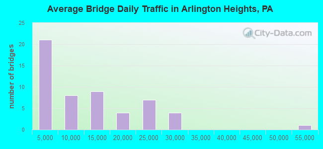
- 579,941Total average daily traffic
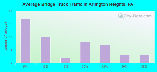
- 101,252Total average daily truck traffic
- National Bridge Inventory (NBI) Registered Bridges for Arlington Heights
- No street view available for this location
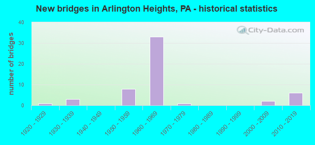
- New bridges - historical statistics
- 11920-1929
- 31930-1939
- 81950-1959
- 331960-1969
- 11970-1979
- 22000-2009
- 62010-2019
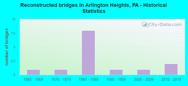
- Reconstructed bridges - Historical Statistics
- 11960-1969
- 11970-1979
- 81980-1989
- 11990-1999
- 12000-2009
- 22010-2019
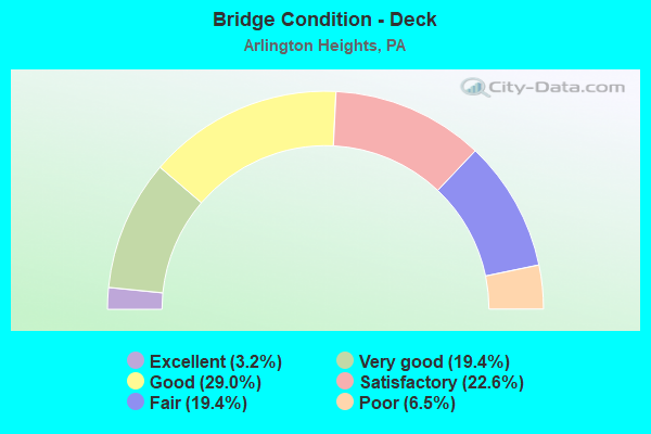
- Bridge Condition - Deck
- 3.2%Excellent
- 19.4%Very good
- 29.0%Good
- 22.6%Satisfactory
- 19.4%Fair
- 6.5%Poor
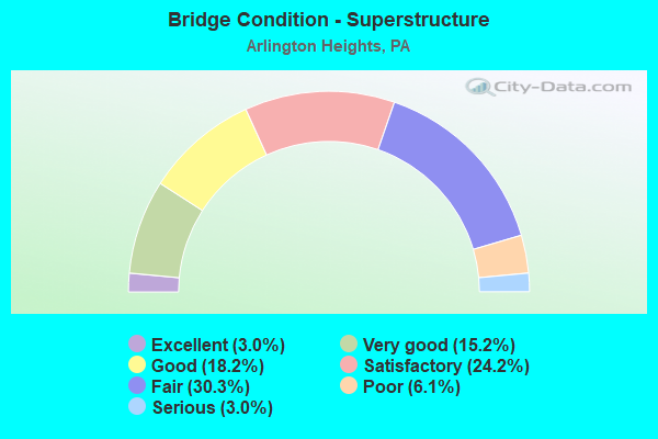
- Bridge Condition - Superstructure
- 3.0%Excellent
- 15.2%Very good
- 18.2%Good
- 24.2%Satisfactory
- 30.3%Fair
- 6.1%Poor
- 3.0%Serious
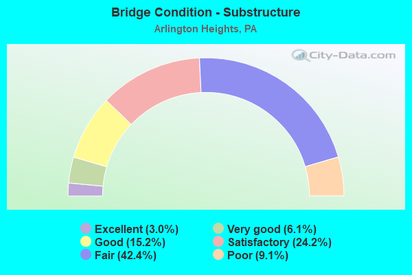
- Bridge Condition - Substructure
- 3.0%Excellent
- 6.1%Very good
- 15.2%Good
- 24.2%Satisfactory
- 42.4%Fair
- 9.1%Poor
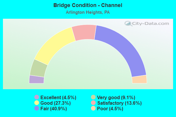
- Bridge Condition - Channel
- 4.5%Excellent
- 9.1%Very good
- 27.3%Good
- 13.6%Satisfactory
- 40.9%Fair
- 4.5%Poor
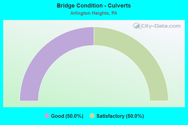
- Bridge Condition - Culverts
- 50.0%Good
- 50.0%Satisfactory
Find on map >> Show street view
Structure Number: 26721, Location: OVER SHAFERS SCHOOLHOUSE (Lat: 40.993461, Lng: -75.255808), Route carried "under" structure: State highway , Year Built: 1963, Structure Length: 0. m, Average Daily Traffic: 1,791 (year 2021), Truck Traffic: 4%, Features Intersected: SR 2005(LR 45019), Facility Carried by Structure: I-80 WB (LR1002)
Minimum Vertical Clearance: 4.82m (15.81ft), Kilometerpoint: 2.393, Lanes on structure: 2, Lanes under structure: 2, Material/Design: Prestressed concrete, Design/Construction: Box Beam or Girders - Single/Spread, Length of Maximum Span: 11.9m (39.0ft)
Find on map >> Show street view
Structure Number: 26722, Location: 1.5 MI.E.OF PA.33 (Lat: 40.989222, Lng: -75.243372), Route carried "under" structure: City street , Year Built: 1963, Structure Length: 0. m, Average Daily Traffic: 200 (year 1992), Truck Traffic: 1%, Features Intersected: TWP. RD 498*, Facility Carried by Structure: I-80 EB (LR 1002)
Minimum Vertical Clearance: 6.71m (22.01ft), Kilometerpoint: 0.000, Lanes on structure: 2, Lanes under structure: 2, Material/Design: Prestressed concrete, Design/Construction: Box Beam or Girders - Single/Spread, Length of Maximum Span: 10.4m (34.1ft)
Find on map >> Show street view
Structure Number: 26724, Location: 1.5 MI.E.OF PA.33 (Lat: 40.989514, Lng: -75.243453), Route carried "under" structure: City street , Year Built: 1963, Structure Length: 0. m, Average Daily Traffic: 200 (year 1992), Truck Traffic: 1%, Features Intersected: TWP.RD 498, Facility Carried by Structure: I-80 WB (LR 1002)
Minimum Vertical Clearance: 4.78m (15.68ft), Kilometerpoint: 0.000, Lanes on structure: 2, Lanes under structure: 2, Material/Design: Prestressed concrete, Design/Construction: Box Beam or Girders - Single/Spread, Length of Maximum Span: 10.4m (34.1ft)
Find on map >> Show street view
Structure Number: 26725, Location: OVER SR 2009(BRIDGE ST) (Lat: 40.985386, Lng: -75.225789), Route carried "under" structure: State highway , Year Built: 1959, Structure Length: 0. m, Average Daily Traffic: 12,556 (year 2021), Truck Traffic: 2%, Features Intersected: SR 2009,POCONO CR., Facility Carried by Structure: I-80 (LR1002)
Minimum Vertical Clearance: 4.82m (15.81ft), Kilometerpoint: 0.000, Lanes on structure: 4, Lanes under structure: 2, Material/Design: Steel continuous, Design/Construction: Stringer/Multi-beam, Length of Maximum Span: 30.8m (101.0ft)
Find on map >> Show street view
Structure Number: 26798, Location: US209 OVER HICKORY VALLEY (Lat: 40.970011, Lng: -75.258186), Route carried "under" structure: State highway , Year Built: 1963, Structure Length: 0. m, Average Daily Traffic: 546 (year 2022), Truck Traffic: 7%, Features Intersected: SR 2010(LR 45009), Facility Carried by Structure: US 209(LR 164 ALT)
Minimum Vertical Clearance: 4.30m (14.11ft), Kilometerpoint: 3.978, Lanes on structure: 4, Lanes under structure: 2, Material/Design: Prestressed concrete, Design/Construction: Stringer/Multi-beam, Length of Maximum Span: 11.3m (37.1ft)
Find on map >> Show street view
Structure Number: 26801, Location: US209 OVER 209 BUS. (Lat: 40.982708, Lng: -75.222128), Route carried "under" structure: Business US 209B, Year Built: 1963, Structure Length: 0. m, Average Daily Traffic: 8,872 (year 2020), Truck Traffic: 4%, Features Intersected: SR2012(US 209 BUSINESS), Facility Carried by Structure: US 209(LR164 ALT.)
Minimum Vertical Clearance: 4.63m (15.19ft), Kilometerpoint: 14.864, Lanes on structure: 4, Lanes under structure: 2, Material/Design: Prestressed concrete, Design/Construction: Stringer/Multi-beam, Length of Maximum Span: 13.1m (43.0ft)
Find on map >> Show street view
Structure Number: 26867, Location: OVER I-80 WB ON RAMP (Lat: 40.986675, Lng: -75.231717), Route carried "under" structure: Ramp State highway , Year Built: 1963, Structure Length: 0. m, Average Daily Traffic: 1,404 (year 2021), Truck Traffic: 7%, Features Intersected: SR 8012 (LR 1002 RAMP B), Facility Carried by Structure: PA 611 (LR 168)
Minimum Vertical Clearance: 4.33m (14.21ft), Kilometerpoint: 0.000, Lanes on structure: 3, Lanes under structure: 1, Material/Design: Concrete, Design/Construction: Tee Beam, Length of Maximum Span: 11.9m (39.0ft)
Find on map >> Show street view
Structure Number: 26974, Location: PA33 INTERCHANGE (Lat: 40.961372, Lng: -75.284119), Route carried "under" structure: State highway 33, Year Built: 1963, Structure Length: 0. m, Average Daily Traffic: 10,116 (year 2020), Truck Traffic: 18%, Features Intersected: PA 33, Facility Carried by Structure: US 209 BUS.(LR164)
Minimum Vertical Clearance: 4.55m (14.93ft), Kilometerpoint: 9.040, Lanes on structure: 2, Lanes under structure: 4, Material/Design: Prestressed concrete, Design/Construction: Stringer/Multi-beam, Length of Maximum Span: 28.0m (91.9ft)
Find on map >> Show street view
Structure Number: 26974, Location: PA33 INTERCHANGE (Lat: 40.961372, Lng: -75.284119), Route carried "under" structure: State highway 33, Year Built: 1963, Structure Length: 0. m, Average Daily Traffic: 9,505 (year 2020), Truck Traffic: 17%, Features Intersected: PA 33, Facility Carried by Structure: US 209 BUS.(LR164)
Minimum Vertical Clearance: 4.42m (14.50ft), Kilometerpoint: 8.964, Lanes on structure: 2, Lanes under structure: 4, Material/Design: Prestressed concrete, Design/Construction: Stringer/Multi-beam, Length of Maximum Span: 28.0m (91.9ft)
Find on map >> Show street view
Structure Number: 27132, Location: NINTH ST.EXIT 303(47) (Lat: 40.996667, Lng: -75.271667), Route carried "under" structure: Interstate 80, Year Built: 1963, Structure Length: 0. m, Average Daily Traffic: 26,093 (year 2022), Truck Traffic: 22%, Features Intersected: I-80 (LR 1002)
Minimum Vertical Clearance: 5.97m (19.59ft), Kilometerpoint: 35.056, Lanes on structure: 1, Lanes under structure: 4, Material/Design: Steel continuous, Design/Construction: Stringer/Multi-beam, Length of Maximum Span: 23.2m (76.1ft)
Find on map >> Show street view
Structure Number: 27132, Location: NINTH ST.EXIT 303(47) (Lat: 40.996667, Lng: -75.271667), Route carried "under" structure: Interstate 80, Year Built: 1963, Structure Length: 0. m, Average Daily Traffic: 25,844 (year 2022), Truck Traffic: 22%, Features Intersected: I-80 (LR 1002)
Minimum Vertical Clearance: 5.11m (16.77ft), Kilometerpoint: 34.846, Lanes on structure: 1, Lanes under structure: 4, Material/Design: Steel continuous, Design/Construction: Stringer/Multi-beam, Length of Maximum Span: 23.2m (76.1ft)
Find on map >> Show street view
Structure Number: 27133, Location: I80WB EX.302A(46A)TO209SB (Lat: 40.958333, Lng: -75.283333), Route carried "under" structure: Interstate 80, Year Built: 1963, Structure Length: 0. m, Average Daily Traffic: 25,844 (year 2022), Truck Traffic: 22%, Features Intersected: I-80(LR 1002)
Minimum Vertical Clearance: 5.00m (16.40ft), Kilometerpoint: 35.647, Lanes on structure: 2, Lanes under structure: 4, Material/Design: Prestressed concrete, Design/Construction: Stringer/Multi-beam, Length of Maximum Span: 17.7m (58.1ft)
Find on map >> Show street view
Structure Number: 27133, Location: I80WB EX.302A(46A)TO209SB (Lat: 40.958333, Lng: -75.283333), Route carried "under" structure: Interstate 80, Year Built: 1963, Structure Length: 0. m, Average Daily Traffic: 26,093 (year 2022), Truck Traffic: 22%, Features Intersected: I-80(LR 1002)
Minimum Vertical Clearance: 4.97m (16.31ft), Kilometerpoint: 35.863, Lanes on structure: 2, Lanes under structure: 4, Material/Design: Prestressed concrete, Design/Construction: Stringer/Multi-beam, Length of Maximum Span: 17.7m (58.1ft)