Bridge Statistics for Auburn, Washington (WA)
Condition, Traffic, Stress, Structural Evaluation, Project Costs
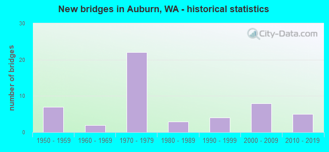
- New bridges - historical statistics
- 71950-1959
- 21960-1969
- 221970-1979
- 31980-1989
- 41990-1999
- 82000-2009
- 52010-2019
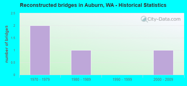
- Reconstructed bridges - Historical Statistics
- 21970-1979
- 11980-1989
- 01990-1999
- 12000-2009
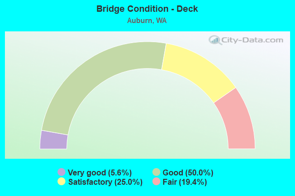
- Bridge Condition - Deck
- 5.6%Very good
- 50.0%Good
- 25.0%Satisfactory
- 19.4%Fair
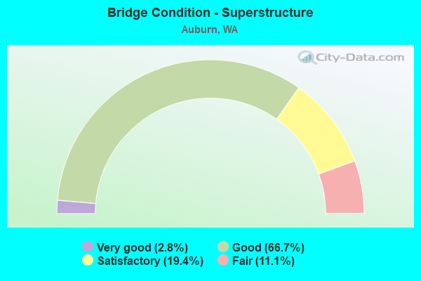
- Bridge Condition - Superstructure
- 2.8%Very good
- 66.7%Good
- 19.4%Satisfactory
- 11.1%Fair

- Bridge Condition - Substructure
- 5.6%Very good
- 72.2%Good
- 19.4%Satisfactory
- 2.8%Fair
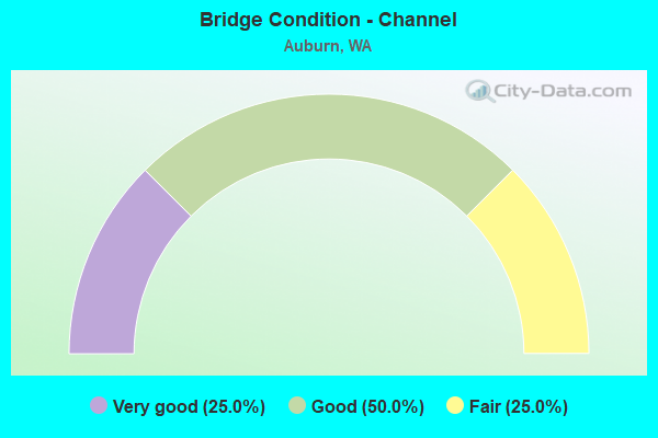
- Bridge Condition - Channel
- 25.0%Very good
- 50.0%Good
- 25.0%Fair
Find on map >> Show street view
Structure Number: 6066A, Location: JCT SR 18 (Lat: 47.302972, Lng: -122.225833), Route carried "under" structure: State highway 164, Year Built: 1959, Structure Length: 0. m, Average Daily Traffic: 27,718 (year 2019), Truck Traffic: 4%, Features Intersected: SR 164, Facility Carried by Structure: SR 18
Minimum Vertical Clearance: 4.98m (16.34ft), Kilometerpoint: 0.499, Lanes on structure: 5, Lanes under structure: 5, Material/Design: Concrete, Design/Construction: Slab, Length of Maximum Span: 24.1m (79.1ft)
Find on map >> Show street view
Structure Number: 8853A, Location: 0.1 N JCT SR 18 (Lat: 47.308364, Lng: -122.249500), Route carried "under" structure: State highway 167, Year Built: 1972, Structure Length: 0. m, Average Daily Traffic: 44,417 (year 2019), Truck Traffic: 10%, Features Intersected: SR 167, Facility Carried by Structure: W MAIN ST
Minimum Vertical Clearance: 5.49m (18.01ft), Kilometerpoint: 23.770, Lanes on structure: 4, Lanes under structure: 7, Material/Design: Concrete continuous, Design/Construction: Box Beam or Girders - Multiple, Length of Maximum Span: 44.5m (146.0ft)
Find on map >> Show street view
Structure Number: 8853B, Location: 1.1 N JCT SR 18 (Lat: 47.322417, Lng: -122.245528), Route carried "under" structure: State highway 167, Year Built: 1972, Structure Length: 0. m, Average Daily Traffic: 116,482 (year 2019), Truck Traffic: 10%, Features Intersected: SR 167, Facility Carried by Structure: 15TH ST NW
Minimum Vertical Clearance: 5.33m (17.49ft), Kilometerpoint: 25.379, Lanes on structure: 6, Lanes under structure: 6, Material/Design: Prestressed concrete continuous, Design/Construction: Stringer/Multi-beam, Length of Maximum Span: 41.1m (134.8ft)
Find on map >> Show street view
Structure Number: 8853C, Location: 2.3 N JCT SR 18 (Lat: 47.340167, Lng: -122.245389), Route carried "under" structure: State highway 167, Year Built: 1971, Structure Length: 0. m, Average Daily Traffic: 132,510 (year 2019), Truck Traffic: 10%, Features Intersected: SR 167, Facility Carried by Structure: 37TH ST NW
Minimum Vertical Clearance: 5.13m (16.83ft), Kilometerpoint: 27.359, Lanes on structure: 4, Lanes under structure: 6, Material/Design: Prestressed concrete continuous, Design/Construction: Stringer/Multi-beam, Length of Maximum Span: 41.1m (134.8ft)
Find on map >> Show street view
Structure Number: 9236A, Location: 2.3 N PIERCE CO (Lat: 47.295694, Lng: -122.257778), Route carried "under" structure: State highway 167, Year Built: 1975, Structure Length: 0. m, Average Daily Traffic: 92,539 (year 2019), Truck Traffic: 10%, Features Intersected: SR 167, Facility Carried by Structure: 15TH ST SW
Minimum Vertical Clearance: 5.05m (16.57ft), Kilometerpoint: 22.289, Lanes on structure: 6, Lanes under structure: 5, Material/Design: Concrete continuous, Design/Construction: Box Beam or Girders - Multiple, Length of Maximum Span: 46.3m (151.9ft)
Find on map >> Show street view
Structure Number: 9236B, Location: 2.3 E JCT I-5 (Lat: 47.301889, Lng: -122.252778), Route carried "under" structure: State highway 18, Year Built: 1973, Structure Length: 0. m, Average Daily Traffic: 60,520 (year 2019), Truck Traffic: 9%, Features Intersected: SR 18, Facility Carried by Structure: SR 167 NB
Minimum Vertical Clearance: 7.06m (23.16ft), Kilometerpoint: 4.651, Lanes on structure: 3, Lanes under structure: 7, Material/Design: Prestressed concrete continuous, Design/Construction: Stringer/Multi-beam, Length of Maximum Span: 27.4m (89.9ft)
Find on map >> Show street view
Structure Number: 9236C, Location: 2.3 E JCT I-5 (Lat: 47.301944, Lng: -122.253278), Route carried "under" structure: State highway 18, Year Built: 1973, Structure Length: 0. m, Average Daily Traffic: 60,520 (year 2019), Truck Traffic: 9%, Features Intersected: SR 18, Facility Carried by Structure: SR 167
Minimum Vertical Clearance: 6.45m (21.16ft), Kilometerpoint: 4.619, Lanes on structure: 3, Lanes under structure: 4, Material/Design: Prestressed concrete continuous, Design/Construction: Stringer/Multi-beam, Length of Maximum Span: 27.4m (89.9ft)
Find on map >> Show street view
Structure Number: 9236D, Location: 2.7 N PIERCE CO (Lat: 47.299500, Lng: -122.253000), Route carried "under" structure: Ramp State highway 167, Year Built: 1975, Structure Length: 0. m, Average Daily Traffic: 10,471 (year 2019), Truck Traffic: 19%, Features Intersected: N-E RAMP, Facility Carried by Structure: NB RAMP
Minimum Vertical Clearance: 5.16m (16.93ft), Kilometerpoint: 0.579, Lanes on structure: 1, Lanes under structure: 1, Material/Design: Concrete continuous, Design/Construction: Box Beam or Girders - Multiple, Length of Maximum Span: 38.1m (125.0ft)
Find on map >> Show street view
Structure Number: 9236F, Location: 2.3 E JCT I-5 (Lat: 47.301889, Lng: -122.252417), Route carried "under" structure: State highway 18, Year Built: 1974, Structure Length: 0. m, Average Daily Traffic: 60,520 (year 2019), Truck Traffic: 9%, Features Intersected: SR 18, Facility Carried by Structure: SR 167 RAMP
Minimum Vertical Clearance: 6.65m (21.82ft), Kilometerpoint: 4.683, Lanes on structure: 2, Lanes under structure: 4, Material/Design: Prestressed concrete continuous, Design/Construction: Stringer/Multi-beam, Length of Maximum Span: 27.4m (89.9ft)
Find on map >> Show street view
Structure Number: 12555A, Location: 0.6 E JCT SR 164 (Lat: 47.303472, Lng: -122.213667), Route carried "under" structure: City street , Year Built: 1984, Structure Length: 0. m, Average Daily Traffic: 18,226 (year 2017), Truck Traffic: 5%, Features Intersected: M STREET, Facility Carried by Structure: SR 18
Minimum Vertical Clearance: 10.79m (35.40ft), Kilometerpoint: 1.030, Lanes on structure: 4, Lanes under structure: 4, Material/Design: Prestressed concrete, Design/Construction: Stringer/Multi-beam, Length of Maximum Span: 36.3m (119.1ft)
Find on map >> Show street view
Structure Number: 14354A, Location: 2.3 E JCT SR 164 (Lat: 47.300139, Lng: -122.180550), Route carried "under" structure: County highway , Year Built: 1995, Structure Length: 0. m, Average Daily Traffic: 9,224 (year 2016), Truck Traffic: 5%, Features Intersected: BNRR, AUBURN-BLK DIAMOND, Facility Carried by Structure: SR 18
Minimum Vertical Clearance: 8.46m (27.76ft), Kilometerpoint: 0.209, Lanes on structure: 3, Lanes under structure: 2, Material/Design: Prestressed concrete continuous, Design/Construction: Stringer/Multi-beam, Length of Maximum Span: 22.3m (73.2ft)
Find on map >> Show street view
Structure Number: 18665A, Location: 2.3 E JCT I-5 (Lat: 47.301972, Lng: -122.253000), Route carried "under" structure: State highway 18, Year Built: 2016, Structure Length: 0. m, Average Daily Traffic: 60,520 (year 2019), Truck Traffic: 9%, Features Intersected: SR 18, Facility Carried by Structure: SR 167 SB HOV
Minimum Vertical Clearance: 6.88m (22.57ft), Kilometerpoint: 4.635, Lanes on structure: 1, Lanes under structure: 4, Toll: On toll road, Material/Design: Prestressed concrete, Design/Construction: Stringer/Multi-beam, Length of Maximum Span: 56.1m (184.1ft)
Find on map >> Show street view
Structure Number: 89201, Location: 0.1 MI N OF SR 18 (Lat: 47.303875, Lng: -122.213611), Route carried "under" structure: City street 55, Year Built: 2014, Structure Length: 0. m, Average Daily Traffic: 6,000 (year 2020), Truck Traffic: 5%, Features Intersected: M Street, Facility Carried by Structure: BNSF MAIN LINE
Minimum Vertical Clearance: 5.03m (16.50ft), Kilometerpoint: 0.001, Lanes under structure: 4, Material/Design: Steel, Design/Construction: Girder and Floorbeam System, Length of Maximum Span: 27.7m (90.9ft)
Find on map >> Show street view
Structure Number: 89202, Location: 0.1 MI N OF SR 18 (Lat: 47.303803, Lng: -122.213611), Route carried "under" structure: City street 55, Year Built: 2018, Structure Length: 0. m, Average Daily Traffic: 6,000 (year 2020), Truck Traffic: 15%, Features Intersected: M STREET, Facility Carried by Structure: BNSF SIDING LINE
Minimum Vertical Clearance: 5.03m (16.50ft), Kilometerpoint: 0.001, Lanes under structure: 5, Material/Design: Steel, Design/Construction: Girder and Floorbeam System, Length of Maximum Span: 27.7m (90.9ft)