Bridge Statistics for Bay City, Michigan (MI)
Condition, Traffic, Stress, Structural Evaluation, Project Costs
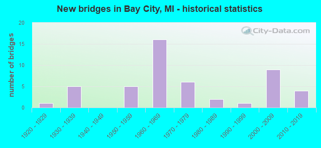
- New bridges - historical statistics
- 11920-1929
- 51930-1939
- 51950-1959
- 161960-1969
- 61970-1979
- 21980-1989
- 11990-1999
- 92000-2009
- 42010-2019
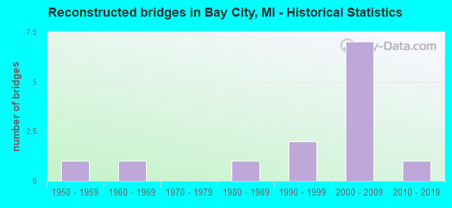
- Reconstructed bridges - Historical Statistics
- 11950-1959
- 11960-1969
- 01970-1979
- 11980-1989
- 21990-1999
- 72000-2009
- 12010-2019
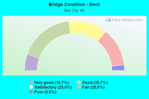
- Bridge Condition - Deck
- 10.7%Very good
- 35.7%Good
- 25.0%Satisfactory
- 25.0%Fair
- 3.6%Poor
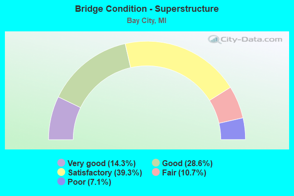
- Bridge Condition - Superstructure
- 14.3%Very good
- 28.6%Good
- 39.3%Satisfactory
- 10.7%Fair
- 7.1%Poor
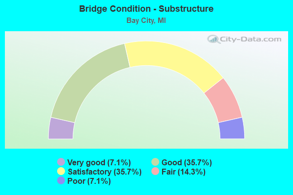
- Bridge Condition - Substructure
- 7.1%Very good
- 35.7%Good
- 35.7%Satisfactory
- 14.3%Fair
- 7.1%Poor
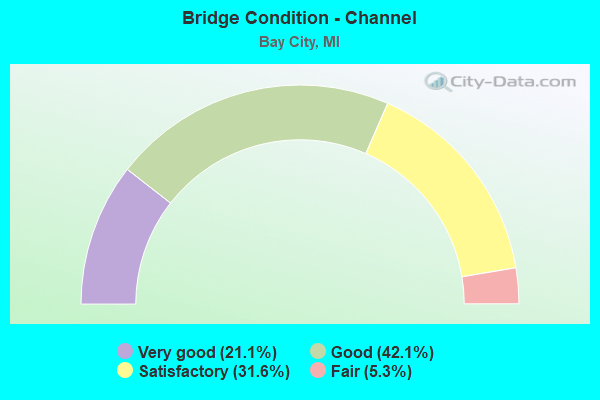
- Bridge Condition - Channel
- 21.1%Very good
- 42.1%Good
- 31.6%Satisfactory
- 5.3%Fair
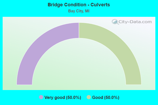
- Bridge Condition - Culverts
- 50.0%Very good
- 50.0%Good
Find on map >> Show street view
Structure Number: 75, Location: 4 MI E & 1.5 MI N TRENARY (Lat: 46.213411, Lng: -86.886439), Route carried "on" structure: Other road , Year Built: 1920, Year Reconstructed: 1968, Status: Posted for load, Structure Length: 0.70m (2.30ft), Average Daily Traffic: 5 (year 1995), Average Future Daily Traffic: 10 (year 2015), Features Intersected: DEXTER CREEK, Facility Carried by Structure: PAULSON ROAD
Minimum Vertical Clearance: 30.48m (100.00ft), Kilometerpoint: 1.197, Lanes on structure: 2, Owner: County Highway Agency, Approaching Roadway Width: 4.9m (16.1ft), Material/Design: Steel, Design/Construction: Stringer/Multi-beam, Number Of Spans In Main Unit: 1, Length of Maximum Span: 6.1m (20.0ft), Curb-To-Curb Width: 3.7m (12.1ft), Out-to-Out Width: 4.8m (15.7ft)
Condition: Deck: Fair, Superstructure: Satisfactory, Substructure: Poor, Channel: Good, Operating Rating: 8.7 metric tons, Method Used To Determine Operating Rating: Load Factor (LF) rating reported by rating factor (RF) method using MS18 loading, Inventory Rating: 5.2 metric tons, Method Used To Determine Inventory Rating: Load Factor (LF) rating reported by rating factor (RF) method using MS18 loading, Structural Evaluation: High priority of corrective action, Waterway Adequacy: Equal to present minimum criteria, Approach Roadway Alignment: High priority of corrective action, Bridge Posting: Required (Relationship of Operating Rating to Maximum Legal Load: > 39.9% below), Designated Inspection Frequency: Every 24 months, Inspection Date: September 2021, Deck Structure Type: Wood or Timber, Wearing Surface/Protective System: Wearing Surface: Wood or Timber
Find on map >> Show street view
Structure Number: 58, Location: 0.4 MI NE OF I-75 (Lat: 43.564653, Lng: -83.941003), Route carried "on" structure: State highway 84, Year Built: 2009, Status: Open, Structure Length: 0.66m (2.17ft), Average Daily Traffic: 11,860 (year 2010), Truck Traffic: 3%, Average Future Daily Traffic: 13,102 (year 2030), Design Load: Greater than HL93, Features Intersected: DUTCH CREEK
Minimum Vertical Clearance: 30.48m (100.00ft), Kilometerpoint: 5.412, Lanes on structure: 2, Base Highway Network: Yes (Inventory Route: 76, Subroute: 10), Owner: State Highway Agency, Approaching Roadway Width: 14.6m (47.9ft), Material/Design: Concrete, Design/Construction: Culvert, Number Of Spans In Main Unit: 1, Length of Maximum Span: 6.1m (20.0ft), Out-to-Out Width: 19.6m (64.3ft)
Condition: Channel: Very good, Culverts: Very good, Operating Rating: 97.2 metric tons, Method Used To Determine Operating Rating: Load Factor (LF) rating reported by rating factor (RF) method using MS18 loading, Inventory Rating: 89.7 metric tons, Method Used To Determine Inventory Rating: Load Factor (LF) rating reported by rating factor (RF) method using MS18 loading, Structural Evaluation: Equal to present desirable criteria, Waterway Adequacy: Equal to present minimum criteria, Approach Roadway Alignment: Equal to present minimum criteria, Designated Inspection Frequency: Every 24 months, Inspection Date: September 2021, Wearing Surface/Protective System: Wearing Surface: Bituminous, Membrane: Preformed Fabric
Find on map >> Show street view
Structure Number: 581, Location: 1.0 MI N OF M-13 JCT (Lat: 43.643683, Lng: -83.913325), Route carried "on" structure: State highway 247, Year Built: 1935, Year Reconstructed: 1999, Status: Open, Structure Length: 4.11m (13.48ft), Average Daily Traffic: 5,842 (year 2007), Truck Traffic: 2%, Average Future Daily Traffic: 11,328 (year 2018), Design Load: H 15, Features Intersected: KAWKAWLIN RIVER
Minimum Vertical Clearance: 30.48m (100.00ft), Kilometerpoint: 1.756, Lanes on structure: 2, Owner: State Highway Agency, Approaching Roadway Width: 11.6m (38.1ft), Material/Design: Prestressed concrete, Design/Construction: Stringer/Multi-beam, Number Of Spans In Main Unit: 3, Length of Maximum Span: 13.3m (43.6ft), Curb-To-Curb Width: 12.1m (39.7ft), Out-to-Out Width: 12.8m (42.0ft)
Condition: Deck: Good, Superstructure: Very good, Substructure: Satisfactory, Channel: Good, Operating Rating: 66.1 metric tons, Method Used To Determine Operating Rating: Load Factor (LF) rating reported by rating factor (RF) method using MS18 loading, Inventory Rating: 38.6 metric tons, Method Used To Determine Inventory Rating: Load Factor (LF) rating reported by rating factor (RF) method using MS18 loading, Structural Evaluation: Equal to present minimum criteria, Deck Geometry: Somewhat better than minimum adequacy, Waterway Adequacy: Equal to present desirable criteria, Approach Roadway Alignment: Somewhat better than minimum adequacy, Designated Inspection Frequency: Every 24 months, Underwater Inspection Frequency: Every 60 months, Inspection Date: July 2021, Underwater Inspection Date: July 2020, Deck Structure Type: Concrete Cast-file-Place, Wearing Surface/Protective System: Wearing Surface: Monolithic Concrete, Deck Protection: Epoxy Coated Reinforcing
Find on map >> Show street view
Structure Number: 585, Location: 4.0 MI N OF I-75 JCT (Lat: 43.531178, Lng: -83.881375), Route carried "on" structure: State highway 13, Year Built: 2010, Status: Open, Structure Length: 9.45m (31.00ft), Average Daily Traffic: 6,816 (year 2007), Truck Traffic: 6%, Average Future Daily Traffic: 9,800 (year 2032), Design Load: Greater than HL93, Features Intersected: CHEBOYGANING CREEK
Minimum Vertical Clearance: 30.48m (100.00ft), Kilometerpoint: 1.053, Lanes on structure: 2, Owner: State Highway Agency, Approaching Roadway Width: 13.4m (44.0ft), Material/Design: Prestressed concrete, Design/Construction: Box Beam or Girders - Single/Spread, Number Of Spans In Main Unit: 3, Length of Maximum Span: 36.1m (118.4ft), Curb-To-Curb Width: 13.4m (44.0ft), Out-to-Out Width: 14.4m (47.2ft)
Condition: Deck: Good, Superstructure: Good, Substructure: Satisfactory, Channel: Good, Inventory Rating: 57.2 metric tons, Method Used To Determine Inventory Rating: Load Factor (LF), Structural Evaluation: Equal to present minimum criteria, Deck Geometry: Equal to present minimum criteria, Waterway Adequacy: Equal to present desirable criteria, Approach Roadway Alignment: Equal to present desirable criteria, Designated Inspection Frequency: Every 24 months, Underwater Inspection Frequency: Every 60 months, Inspection Date: May 2021, Underwater Inspection Date: August 2020, Deck Structure Type: Concrete Cast-file-Place, Wearing Surface/Protective System: Wearing Surface: Monolithic Concrete, Deck Protection: Epoxy Coated Reinforcing
Find on map >> Show street view
Structure Number: 586, Location: IN BAY CITY (LAFAYETTE AV (Lat: 43.579686, Lng: -83.898975), Route carried "on" structure: State highway 13, Year Built: 1938, Year Reconstructed: 2005, Status: Open, Structure Length: 15.48m (50.79ft), Average Daily Traffic: 19,666 (year 2007), Truck Traffic: 6%, Average Future Daily Traffic: 12,550 (year 2025), Design Load: HS 20+Mod, Features Intersected: E CHANNEL SAGINAW RIVER
Minimum Vertical Clearance: 30.48m (100.00ft), Kilometerpoint: 0.599, Lanes on structure: 2, Base Highway Network: Yes (Inventory Route: 76, Subroute: 1), Owner: State Highway Agency, Approaching Roadway Width: 9.1m (29.9ft), Navigation Control: Yes ( Vertical Clearance: 6.0m (19.7ft), Horizontal Clearance: 46.0m (150.9ft)), Material/Design: Steel, Design/Construction: Movable - Bascule, Number Of Spans In Main Unit: 1, Number Of Approach Spans: 2, Length of Maximum Span: 56.4m (185.0ft), Curb or Sidewalk Widths: Left: 1.8m (5.9ft), Right: 1.8m (5.9ft), Curb-To-Curb Width: 9.1m (29.9ft), Out-to-Out Width: 13.7m (44.9ft)
Condition: Deck: Fair, Superstructure: Poor, Substructure: Fair, Channel: Satisfactory, Operating Rating: 46.3 metric tons, Method Used To Determine Operating Rating: Load Factor (LF) rating reported by rating factor (RF) method using MS18 loading, Inventory Rating: 27.9 metric tons, Method Used To Determine Inventory Rating: Load Factor (LF) rating reported by rating factor (RF) method using MS18 loading, Structural Evaluation: Meets minimum limits, Deck Geometry: Meets minimum limits, Waterway Adequacy: Somewhat better than minimum adequacy, Approach Roadway Alignment: Meets minimum limits, Length Of Structure Improvement: 15.48m (50.79ft), Designated Inspection Frequency: Every 15 months, Critical Feature Inspection Frequency: Every 15 months, Underwater Inspection Frequency: Every 36 months, Other Special Inspection Frequency: Every 9 months, Inspection Date: April 2021, Critical Feature Inspection Date: April 2021, Underwater Inspection Date: August 2020, Other Special Inspection Date: January 2022, Deck Structure Type: Concrete Cast-file-Place, Wearing Surface/Protective System: Wearing Surface: Epoxy Overlay, Deck Protection: Epoxy Coated Reinforcing
Find on map >> Show street view
Structure Number: 587, Location: IN BAY CITY (LAFAYETTE AV (Lat: 43.580061, Lng: -83.903397), Route carried "on" structure: State highway 13, Year Built: 1938, Year Reconstructed: 2005, Status: Open, Structure Length: 15.48m (50.79ft), Average Daily Traffic: 19,666 (year 2007), Truck Traffic: 6%, Average Future Daily Traffic: 25,100 (year 2025), Design Load: HS 20, Features Intersected: W CHANNEL SAGINAW RIVER
Minimum Vertical Clearance: 30.48m (100.00ft), Kilometerpoint: 0.895, Lanes on structure: 2, Base Highway Network: Yes (Inventory Route: 76, Subroute: 1), Owner: State Highway Agency, Approaching Roadway Width: 9.1m (29.9ft), Navigation Control: Yes ( Vertical Clearance: 0.3m (1.0ft), Horizontal Clearance: 22.0m (72.2ft)), Material/Design: Steel continuous, Design/Construction: Stringer/Multi-beam, Number Of Spans In Main Unit: 6, Length of Maximum Span: 29.9m (98.1ft), Curb or Sidewalk Widths: Left: 1.8m (5.9ft), Right: 1.8m (5.9ft), Curb-To-Curb Width: 9.1m (29.9ft), Out-to-Out Width: 13.7m (44.9ft)
Condition: Deck: Satisfactory, Superstructure: Fair, Substructure: Poor, Channel: Good, Operating Rating: 64.5 metric tons, Method Used To Determine Operating Rating: Load Factor (LF) rating reported by rating factor (RF) method using MS18 loading, Inventory Rating: 38.6 metric tons, Method Used To Determine Inventory Rating: Load Factor (LF) rating reported by rating factor (RF) method using MS18 loading, Structural Evaluation: Meets minimum limits, Deck Geometry: Meets minimum limits, Waterway Adequacy: Somewhat better than minimum adequacy, Approach Roadway Alignment: Somewhat better than minimum adequacy, Length Of Structure Improvement: 15.24m (50.00ft), Designated Inspection Frequency: Every 24 months, Underwater Inspection Frequency: Every 60 months, Other Special Inspection Frequency: Every 24 months, Inspection Date: March 2021, Underwater Inspection Date: August 2020, Other Special Inspection Date: August 2021, Bridge Improvement Cost: $1,957,000, Roadway Improvement Cost: $8,000, Total Project Cost: $92,000, Deck Structure Type: Concrete Cast-file-Place, Wearing Surface/Protective System: Wearing Surface: Latex Concrete
Find on map >> Show street view
Structure Number: 588, Location: IN KAWKAWLIN (Lat: 43.653733, Lng: -83.944494), Route carried "on" structure: State highway 13, Year Built: 1931, Year Reconstructed: 2009, Status: Open, Structure Length: 3.35m (10.99ft), Average Daily Traffic: 17,442 (year 2007), Truck Traffic: 3%, Average Future Daily Traffic: 18,101 (year 2018), Design Load: H 15, Features Intersected: KAWKAWLIN RIVER
Minimum Vertical Clearance: 30.48m (100.00ft), Kilometerpoint: 13.783, Lanes on structure: 4, Base Highway Network: Yes (Inventory Route: 76, Subroute: 10), Owner: State Highway Agency, Approaching Roadway Width: 18.3m (60.0ft), Skew: 31 degrees, Material/Design: Steel, Design/Construction: Stringer/Multi-beam, Number Of Spans In Main Unit: 2, Length of Maximum Span: 16.7m (54.8ft), Curb or Sidewalk Widths: Left: 0.0m, Right: 1.5m (4.9ft), Curb-To-Curb Width: 16.3m (53.5ft), Out-to-Out Width: 19.0m (62.3ft)
Condition: Deck: Fair, Superstructure: Good, Substructure: Good, Channel: Very good, Operating Rating: 65.2 metric tons, Method Used To Determine Operating Rating: Load Factor (LF), Inventory Rating: 39.1 metric tons, Method Used To Determine Inventory Rating: Load Factor (LF), Structural Evaluation: Better than present minimum criteria, Deck Geometry: Meets minimum limits, Waterway Adequacy: Equal to present desirable criteria, Approach Roadway Alignment: Better than present minimum criteria, Designated Inspection Frequency: Every 24 months, Inspection Date: November 2020, Deck Structure Type: Concrete Cast-file-Place, Wearing Surface/Protective System: Wearing Surface: Latex Concrete
Find on map >> Show street view
Structure Number: 597, Location: 2.4 MI N OF SAGINAW COL (Lat: 43.557758, Lng: -83.946261), Route carried "on" structure: Interstate 75, Year Built: 1960, Year Reconstructed: 2009, Status: Open, Structure Length: 3.48m (11.42ft), Average Daily Traffic: 57,600 (year 2009), Truck Traffic: 6%, Average Future Daily Traffic: 76,000 (year 2032), Design Load: HS 20, Features Intersected: SQUACONNING CREEK
Minimum Vertical Clearance: 30.48m (100.00ft), Kilometerpoint: 3.953, Lanes on structure: 5, Base Highway Network: Yes (Inventory Route: 76, Subroute: 1), Owner: State Highway Agency, Approaching Roadway Width: 25.6m (84.0ft), Skew: 3 degrees, Material/Design: Steel, Design/Construction: Stringer/Multi-beam, Number Of Spans In Main Unit: 2, Length of Maximum Span: 17.0m (55.8ft), Curb-To-Curb Width: 25.9m (85.0ft), Out-to-Out Width: 26.9m (88.3ft)
Condition: Deck: Good, Superstructure: Very good, Substructure: Good, Channel: Good, Operating Rating: 67.7 metric tons, Method Used To Determine Operating Rating: Load Factor (LF), Inventory Rating: 40.6 metric tons, Method Used To Determine Inventory Rating: Load Factor (LF), Structural Evaluation: Better than present minimum criteria, Deck Geometry: Superior to present desirable criteria, Waterway Adequacy: Equal to present minimum criteria, Approach Roadway Alignment: Equal to present desirable criteria, Designated Inspection Frequency: Every 24 months, Inspection Date: May 2020, Deck Structure Type: Concrete Cast-file-Place, Wearing Surface/Protective System: Wearing Surface: Monolithic Concrete, Deck Protection: Epoxy Coated Reinforcing
Find on map >> Show street view
Structure Number: 598, Location: 2.4 MI N OF SAGINAW COL (Lat: 43.556758, Lng: -83.946953), Route carried "on" structure: Interstate 75, Year Built: 1960, Year Reconstructed: 2009, Status: Open, Structure Length: 3.47m (11.38ft), Average Daily Traffic: 57,600 (year 2009), Truck Traffic: 6%, Average Future Daily Traffic: 76,000 (year 2032), Design Load: HS 20, Features Intersected: SQUACONNING CREEK
Minimum Vertical Clearance: 30.48m (100.00ft), Kilometerpoint: 3.893, Lanes on structure: 4, Base Highway Network: Yes (Inventory Route: 76, Subroute: 10), Owner: State Highway Agency, Approaching Roadway Width: 29.3m (96.1ft), Skew: 13 degrees, Material/Design: Steel, Design/Construction: Stringer/Multi-beam, Number Of Spans In Main Unit: 2, Length of Maximum Span: 16.6m (54.5ft), Curb-To-Curb Width: 29.5m (96.8ft), Out-to-Out Width: 30.5m (100.1ft)
Condition: Deck: Good, Superstructure: Good, Substructure: Satisfactory, Channel: Satisfactory, Operating Rating: 64.0 metric tons, Method Used To Determine Operating Rating: Load Factor (LF), Inventory Rating: 38.4 metric tons, Method Used To Determine Inventory Rating: Load Factor (LF), Structural Evaluation: Equal to present minimum criteria, Deck Geometry: Superior to present desirable criteria, Waterway Adequacy: Equal to present desirable criteria, Approach Roadway Alignment: Equal to present desirable criteria, Designated Inspection Frequency: Every 24 months, Inspection Date: May 2020, Deck Structure Type: Concrete Cast-file-Place, Wearing Surface/Protective System: Wearing Surface: Monolithic Concrete, Deck Protection: Epoxy Coated Reinforcing
Find on map >> Show street view
Structure Number: 6, Location: 1.0 MI N OF SAGINAW COL (Lat: 43.536778, Lng: -83.944739), Route carried "on" structure: County highway , Year Built: 1960, Year Reconstructed: 2006, Status: Open, Structure Length: 6.21m (20.37ft), Average Daily Traffic: 528 (year 1993), Truck Traffic: 3%, Average Future Daily Traffic: 230 (year 1977), Design Load: H 15, Features Intersected: I-75, Facility Carried by Structure: AMELITH RD
Minimum Vertical Clearance: 30.48m (100.00ft), Kilometerpoint: 1.674, Lanes on structure: 2, Lanes under structure: 6, Owner: State Highway Agency, Approaching Roadway Width: 7.9m (25.9ft), Material/Design: Steel, Design/Construction: Stringer/Multi-beam, Number Of Spans In Main Unit: 4, Length of Maximum Span: 21.6m (70.9ft), Curb-To-Curb Width: 7.9m (25.9ft), Out-to-Out Width: 10.2m (33.5ft)
Condition: Deck: Satisfactory, Superstructure: Fair, Substructure: Good, Operating Rating: 56.6 metric tons, Method Used To Determine Operating Rating: Load Factor (LF), Inventory Rating: 33.9 metric tons, Method Used To Determine Inventory Rating: Load Factor (LF), Structural Evaluation: Somewhat better than minimum adequacy, Deck Geometry: Somewhat better than minimum adequacy, Underclear: High priority of corrective action, Approach Roadway Alignment: Somewhat better than minimum adequacy, Length Of Structure Improvement: 6.22m (20.41ft), Designated Inspection Frequency: Every 24 months, Inspection Date: September 2020, Bridge Improvement Cost: $190,000, Roadway Improvement Cost: $13,000, Total Project Cost: $157,000, Deck Structure Type: Concrete Cast-file-Place, Wearing Surface/Protective System: Wearing Surface: Latex Concrete
Find on map >> Show street view
Structure Number: 601, Location: 2.6 MI N OF SAGINAW COL (Lat: 43.559944, Lng: -83.947592), Route carried "on" structure: State highway 84, Year Built: 2009, Status: Open, Structure Length: 5.89m (19.32ft), Average Daily Traffic: 11,860 (year 2010), Truck Traffic: 7%, Average Future Daily Traffic: 13,102 (year 2030), Design Load: Greater than HL93, Features Intersected: I-75 NB
Minimum Vertical Clearance: 30.48m (100.00ft), Kilometerpoint: 4.658, Lanes on structure: 2, Lanes under structure: 4, Base Highway Network: Yes (Inventory Route: 76, Subroute: 10), Owner: State Highway Agency, Approaching Roadway Width: 21.9m (71.9ft), Skew: 2 degrees, Material/Design: Steel continuous, Design/Construction: Stringer/Multi-beam, Number Of Spans In Main Unit: 3, Length of Maximum Span: 31.5m (103.3ft), Curb-To-Curb Width: 21.9m (71.9ft), Out-to-Out Width: 23.0m (75.5ft)
Condition: Deck: Good, Superstructure: Good, Substructure: Good, Operating Rating: 66.4 metric tons, Method Used To Determine Operating Rating: Load Factor (LF), Inventory Rating: 39.8 metric tons, Method Used To Determine Inventory Rating: Load Factor (LF), Structural Evaluation: Better than present minimum criteria, Deck Geometry: Superior to present desirable criteria, Underclear: Equal to present minimum criteria, Approach Roadway Alignment: Better than present minimum criteria, Designated Inspection Frequency: Every 24 months, Inspection Date: October 2020, Deck Structure Type: Concrete Cast-file-Place, Wearing Surface/Protective System: Wearing Surface: Monolithic Concrete, Deck Protection: Epoxy Coated Reinforcing
Find on map >> Show street view
Structure Number: 602, Location: 2.6 MI N OF SAGINAW COL (Lat: 43.559322, Lng: -83.948475), Route carried "on" structure: State highway 84, Year Built: 2009, Status: Open, Structure Length: 5.87m (19.26ft), Average Daily Traffic: 11,860 (year 2010), Truck Traffic: 7%, Average Future Daily Traffic: 13,102 (year 2030), Design Load: Greater than HL93, Features Intersected: I-75 SB
Minimum Vertical Clearance: 30.48m (100.00ft), Kilometerpoint: 4.558, Lanes on structure: 2, Lanes under structure: 4, Base Highway Network: Yes (Inventory Route: 76, Subroute: 10), Owner: State Highway Agency, Approaching Roadway Width: 21.9m (71.9ft), Skew: 2 degrees, Material/Design: Steel continuous, Design/Construction: Stringer/Multi-beam, Number Of Spans In Main Unit: 3, Length of Maximum Span: 31.2m (102.4ft), Curb-To-Curb Width: 21.9m (71.9ft), Out-to-Out Width: 23.0m (75.5ft)
Condition: Deck: Good, Superstructure: Satisfactory, Substructure: Good, Operating Rating: 64.5 metric tons, Method Used To Determine Operating Rating: Load Factor (LF), Inventory Rating: 38.7 metric tons, Method Used To Determine Inventory Rating: Load Factor (LF), Structural Evaluation: Equal to present minimum criteria, Deck Geometry: Superior to present desirable criteria, Underclear: Equal to present minimum criteria, Approach Roadway Alignment: Equal to present minimum criteria, Designated Inspection Frequency: Every 24 months, Inspection Date: October 2020, Deck Structure Type: Concrete Cast-file-Place, Wearing Surface/Protective System: Wearing Surface: Monolithic Concrete, Deck Protection: Epoxy Coated Reinforcing
Find on map >> Show street view
Structure Number: 603, Location: 3.0 MI N OF SAGINAW COL (Lat: 43.566167, Lng: -83.949164), Route carried "on" structure: County highway 2008, Year Built: 1960, Status: Open, Structure Length: 6.20m (20.34ft), Average Daily Traffic: 2,376 (year 1995), Truck Traffic: 3%, Average Future Daily Traffic: 260 (year 1977), Design Load: H 15, Features Intersected: I-75, Facility Carried by Structure: HOTCHKISS RD
Minimum Vertical Clearance: 30.48m (100.00ft), Kilometerpoint: 17.687, Lanes on structure: 2, Lanes under structure: 6, Owner: State Highway Agency, Approaching Roadway Width: 11.0m (36.1ft), Material/Design: Steel, Design/Construction: Stringer/Multi-beam, Number Of Spans In Main Unit: 4, Length of Maximum Span: 21.6m (70.9ft), Curb or Sidewalk Widths: Left: 1.1m (3.6ft), Right: 1.1m (3.6ft), Curb-To-Curb Width: 7.9m (25.9ft), Out-to-Out Width: 10.2m (33.5ft)
Condition: Deck: Good, Superstructure: Satisfactory, Substructure: Satisfactory, Operating Rating: 62.1 metric tons, Method Used To Determine Operating Rating: Load Factor (LF), Inventory Rating: 37.2 metric tons, Method Used To Determine Inventory Rating: Load Factor (LF), Structural Evaluation: Equal to present minimum criteria, Deck Geometry: High priority of corrective action, Underclear: High priority of replacement, Approach Roadway Alignment: Somewhat better than minimum adequacy, Length Of Structure Improvement: 6.19m (20.31ft), Designated Inspection Frequency: Every 24 months, Inspection Date: Febuary 2021, Bridge Improvement Cost: $822,000, Roadway Improvement Cost: $13,000, Total Project Cost: $153,000, Deck Structure Type: Concrete Cast-file-Place, Wearing Surface/Protective System: Wearing Surface: Epoxy Overlay, Deck Protection: Epoxy Coated Reinforcing
Find on map >> Show street view
Structure Number: 605, Location: 1.5 MI W OF BAY CITY (Lat: 43.595764, Lng: -83.948131), Route carried "on" structure: US 10, Year Built: 2015, Status: Open, Structure Length: 6.42m (21.06ft), Average Daily Traffic: 12,500 (year 2009), Truck Traffic: 5%, Average Future Daily Traffic: 13,750 (year 2030), Design Load: Greater than HL93, Features Intersected: I-75
Minimum Vertical Clearance: 30.48m (100.00ft), Kilometerpoint: 18.502, Lanes on structure: 3, Lanes under structure: 10, Base Highway Network: Yes (Inventory Route: 76, Subroute: 7), Owner: State Highway Agency, Approaching Roadway Width: 17.7m (58.1ft), Skew: 1 degrees, Material/Design: Prestressed concrete, Design/Construction: Stringer/Multi-beam, Number Of Spans In Main Unit: 2, Length of Maximum Span: 31.4m (103.0ft), Curb-To-Curb Width: 18.0m (59.1ft), Out-to-Out Width: 19.0m (62.3ft)
Condition: Deck: Good, Superstructure: Very good, Substructure: Very good, Operating Rating: 67.4 metric tons, Method Used To Determine Operating Rating: Load and Resistance Factor Rating (LRFR) rating reported by rating factor(RF) method using HL-93 loadings, Inventory Rating: 39.2 metric tons, Method Used To Determine Inventory Rating: Load and Resistance Factor Rating (LRFR) rating reported by rating factor(RF) method using HL-93 loadings, Structural Evaluation: Equal to present desirable criteria, Deck Geometry: Better than present minimum criteria, Underclear: Meets minimum limits, Approach Roadway Alignment: Equal to present desirable criteria, Designated Inspection Frequency: Every 24 months, Inspection Date: June 2021, Deck Structure Type: Concrete Cast-file-Place, Wearing Surface/Protective System: Wearing Surface: Monolithic Concrete, Deck Protection: Epoxy Coated Reinforcing
Find on map >> Show street view
Structure Number: 626, Location: 3.6 MI S OF KAWKAWLIN (Lat: 43.602442, Lng: -83.947850), Route carried "on" structure: Interstate 75, Year Built: 2001, Status: Open, Structure Length: 2.31m (7.58ft), Average Daily Traffic: 18,568 (year 2007), Truck Traffic: 9%, Average Future Daily Traffic: 46,919 (year 2018), Design Load: HS 25 or greater, Features Intersected: MIDLAND ROAD
Minimum Vertical Clearance: 30.48m (100.00ft), Kilometerpoint: 8.956, Lanes on structure: 4, Lanes under structure: 2, Base Highway Network: Yes (Inventory Route: 76, Subroute: 1), Owner: State Highway Agency, Approaching Roadway Width: 17.4m (57.1ft), Skew: 10 degrees, Material/Design: Prestressed concrete, Design/Construction: Stringer/Multi-beam, Number Of Spans In Main Unit: 1, Length of Maximum Span: 21.9m (71.9ft), Curb-To-Curb Width: 21.1m (69.2ft), Out-to-Out Width: 22.1m (72.5ft)
Condition: Deck: Satisfactory, Superstructure: Very good, Substructure: Good, Operating Rating: 71.0 metric tons, Method Used To Determine Operating Rating: Load Factor (LF), Inventory Rating: 42.5 metric tons, Method Used To Determine Inventory Rating: Load Factor (LF), Structural Evaluation: Better than present minimum criteria, Deck Geometry: Better than present minimum criteria, Underclear: Meets minimum limits, Approach Roadway Alignment: Equal to present desirable criteria, Designated Inspection Frequency: Every 24 months, Inspection Date: December 2020, Deck Structure Type: Concrete Cast-file-Place, Wearing Surface/Protective System: Wearing Surface: Monolithic Concrete, Deck Protection: Epoxy Coated Reinforcing
Find on map >> Show street view
Structure Number: 628, Location: 3.0 MI S OF KAWKAWLIN (Lat: 43.609408, Lng: -83.947619), Route carried "on" structure: County highway , Year Built: 1961, Year Reconstructed: 2001, Status: Open, Structure Length: 6.34m (20.80ft), Average Daily Traffic: 1,045 (year 1995), Truck Traffic: 3%, Average Future Daily Traffic: 450 (year 1977), Design Load: H 15, Features Intersected: I-75, Facility Carried by Structure: N UNION RD
Minimum Vertical Clearance: 30.48m (100.00ft), Kilometerpoint: 6.784, Lanes on structure: 2, Lanes under structure: 6, Owner: State Highway Agency, Approaching Roadway Width: 12.8m (42.0ft), Material/Design: Steel, Design/Construction: Stringer/Multi-beam, Number Of Spans In Main Unit: 4, Length of Maximum Span: 21.6m (70.9ft), Curb or Sidewalk Widths: Left: 0.8m (2.6ft), Right: 0.8m (2.6ft), Curb-To-Curb Width: 7.3m (24.0ft), Out-to-Out Width: 9.5m (31.2ft)
Condition: Deck: Fair, Superstructure: Satisfactory, Substructure: Satisfactory, Operating Rating: 55.4 metric tons, Method Used To Determine Operating Rating: Load Factor (LF) rating reported by rating factor (RF) method using MS18 loading, Inventory Rating: 33.4 metric tons, Method Used To Determine Inventory Rating: Load Factor (LF) rating reported by rating factor (RF) method using MS18 loading, Structural Evaluation: Equal to present minimum criteria, Deck Geometry: Meets minimum limits, Underclear: High priority of replacement, Approach Roadway Alignment: Somewhat better than minimum adequacy, Length Of Structure Improvement: 6.34m (20.80ft), Designated Inspection Frequency: Every 24 months, Inspection Date: December 2020, Bridge Improvement Cost: $835,000, Roadway Improvement Cost: $6,000, Total Project Cost: $72,000, Deck Structure Type: Concrete Cast-file-Place, Wearing Surface/Protective System: Wearing Surface: Latex Concrete
Find on map >> Show street view
Structure Number: 63, Location: 2.0 MI S OF KAWKAWLIN (Lat: 43.624106, Lng: -83.954489), Route carried "on" structure: County highway 2008, Year Built: 1968, Year Reconstructed: 2019, Status: Open, Structure Length: 9.67m (31.73ft), Average Daily Traffic: 6,620 (year 2016), Truck Traffic: 3%, Average Future Daily Traffic: 7,613 (year 2036), Design Load: H 20, Features Intersected: I-75, Facility Carried by Structure: WILDER RD
Minimum Vertical Clearance: 30.48m (100.00ft), Kilometerpoint: 2.026, Lanes on structure: 2, Lanes under structure: 4, Base Highway Network: Yes (Inventory Route: 76, Subroute: 8), Owner: State Highway Agency, Approaching Roadway Width: 13.4m (44.0ft), Skew: 4 degrees, Material/Design: Steel, Design/Construction: Stringer/Multi-beam, Number Of Spans In Main Unit: 5, Length of Maximum Span: 24.3m (79.7ft), Curb-To-Curb Width: 13.4m (44.0ft), Out-to-Out Width: 14.1m (46.3ft)
Condition: Deck: Very good, Superstructure: Good, Substructure: Very good, Operating Rating: 63.5 metric tons, Method Used To Determine Operating Rating: Load Factor (LF) rating reported by rating factor (RF) method using MS18 loading, Inventory Rating: 37.9 metric tons, Method Used To Determine Inventory Rating: Load Factor (LF) rating reported by rating factor (RF) method using MS18 loading, Structural Evaluation: Better than present minimum criteria, Deck Geometry: Equal to present minimum criteria, Underclear: Meets minimum limits, Approach Roadway Alignment: Equal to present desirable criteria, Designated Inspection Frequency: Every 24 months, Inspection Date: March 2021, Deck Structure Type: Concrete Cast-file-Place, Wearing Surface/Protective System: Wearing Surface: Monolithic Concrete, Deck Protection: Epoxy Coated Reinforcing
Find on map >> Show street view
Structure Number: 646, Location: IN BAY CITY (Lat: 43.596147, Lng: -83.892517), Route carried "on" structure: State highway 25, Year Built: 1958, Year Reconstructed: 2005, Status: Open, Structure Length: 26.03m (85.40ft), Average Daily Traffic: 30,724 (year 2018), Truck Traffic: 3%, Average Future Daily Traffic: 35,333 (year 2038), Design Load: HS 20, Features Intersected: SAGINAW RIVER & JFK DR
Minimum Vertical Clearance: 30.48m (100.00ft), Kilometerpoint: 4.527, Lanes on structure: 4, Lanes under structure: 2, Base Highway Network: Yes (Inventory Route: 76, Subroute: 4), Owner: State Highway Agency, Approaching Roadway Width: 17.1m (56.1ft), Skew: 20 degrees, Navigation Control: Yes ( Vertical Clearance: 0.3m (1.0ft), Horizontal Clearance: 45.0m (147.6ft)), Material/Design: Steel, Design/Construction: Movable - Bascule, Number Of Spans In Main Unit: 1, Number Of Approach Spans: 6, Length of Maximum Span: 56.4m (185.0ft), Curb or Sidewalk Widths: Left: 1.5m (4.9ft), Right: 1.5m (4.9ft), Curb-To-Curb Width: 15.8m (51.8ft), Out-to-Out Width: 20.6m (67.6ft)
Condition: Deck: Fair, Superstructure: Fair, Substructure: Satisfactory, Channel: Good, Operating Rating: 58.0 metric tons, Method Used To Determine Operating Rating: Load Factor (LF) rating reported by rating factor (RF) method using MS18 loading, Inventory Rating: 34.7 metric tons, Method Used To Determine Inventory Rating: Load Factor (LF) rating reported by rating factor (RF) method using MS18 loading, Structural Evaluation: Somewhat better than minimum adequacy, Deck Geometry: Meets minimum limits, Underclear: Somewhat better than minimum adequacy, Waterway Adequacy: Somewhat better than minimum adequacy, Approach Roadway Alignment: Somewhat better than minimum adequacy, Length Of Structure Improvement: 26.03m (85.40ft), Designated Inspection Frequency: Every 15 months, Critical Feature Inspection Frequency: Every 15 months, Underwater Inspection Frequency: Every 60 months, Other Special Inspection Frequency: Every 4 months, Inspection Date: July 2021, Critical Feature Inspection Date: July 2021, Underwater Inspection Date: August 2020, Other Special Inspection Date: March 2022, Bridge Improvement Cost: $1,454,000, Roadway Improvement Cost: $140,000, Total Project Cost: $1,594,000, Deck Structure Type: Open Grating, Wearing Surface/Protective System: Wearing Surface: Epoxy Overlay, Deck Protection: Epoxy Coated Reinforcing
Find on map >> Show street view
Structure Number: 649, Location: IN BAY CITY (Lat: 43.597250, Lng: -83.898053), Route carried "on" structure: State highway 25, Year Built: 1957, Year Reconstructed: 1993, Status: Open, Structure Length: 7.51m (24.64ft), Average Daily Traffic: 30,724 (year 2018), Truck Traffic: 3%, Average Future Daily Traffic: 35,333 (year 2038), Design Load: HS 25 or greater, Features Intersected: CM RR
Minimum Vertical Clearance: 30.48m (100.00ft), Kilometerpoint: 4.030, Lanes on structure: 4, Base Highway Network: Yes (Inventory Route: 76, Subroute: 4), Owner: State Highway Agency, Approaching Roadway Width: 17.1m (56.1ft), Skew: 20 degrees, Material/Design: Prestressed concrete, Design/Construction: Box Beam or Girders - Multiple, Number Of Spans In Main Unit: 5, Length of Maximum Span: 16.3m (53.5ft), Curb or Sidewalk Widths: Left: 1.5m (4.9ft), Right: 1.5m (4.9ft), Curb-To-Curb Width: 15.8m (51.8ft), Out-to-Out Width: 20.8m (68.2ft)
Condition: Deck: Very good, Superstructure: Satisfactory, Substructure: Good, Operating Rating: 65.4 metric tons, Method Used To Determine Operating Rating: Load Factor (LF) rating reported by rating factor (RF) method using MS18 loading, Inventory Rating: 39.2 metric tons, Method Used To Determine Inventory Rating: Load Factor (LF) rating reported by rating factor (RF) method using MS18 loading, Structural Evaluation: Equal to present minimum criteria, Deck Geometry: Meets minimum limits, Underclear: Somewhat better than minimum adequacy, Approach Roadway Alignment: Somewhat better than minimum adequacy, Designated Inspection Frequency: Every 24 months, Inspection Date: August 2021, Bridge Improvement Cost: $365,000, Deck Structure Type: Concrete Cast-file-Place, Wearing Surface/Protective System: Wearing Surface: Monolithic Concrete, Deck Protection: Epoxy Coated Reinforcing
Find on map >> Show street view
Structure Number: 67, Location: 1.9 MI S OF KAWKAWLIN (Lat: 43.624036, Lng: -83.944058), Route carried "on" structure: County highway 2008, Year Built: 1961, Status: Open, Structure Length: 6.47m (21.23ft), Average Daily Traffic: 6,349 (year 2014), Truck Traffic: 5%, Average Future Daily Traffic: 7,301 (year 2034), Design Load: HS 20, Features Intersected: M-13/I-75 CONN, Facility Carried by Structure: WILDER RD
Minimum Vertical Clearance: 30.48m (100.00ft), Kilometerpoint: 2.868, Lanes on structure: 2, Lanes under structure: 4, Base Highway Network: Yes (Inventory Route: 76, Subroute: 8), Owner: State Highway Agency, Approaching Roadway Width: 9.4m (30.8ft), Skew: 3 degrees, Material/Design: Steel, Design/Construction: Stringer/Multi-beam, Number Of Spans In Main Unit: 4, Length of Maximum Span: 20.9m (68.6ft), Curb-To-Curb Width: 9.1m (29.9ft), Out-to-Out Width: 10.1m (33.1ft)
Condition: Deck: Very good, Superstructure: Good, Substructure: Good, Operating Rating: 68.7 metric tons, Method Used To Determine Operating Rating: Load Factor (LF) rating reported by rating factor (RF) method using MS18 loading, Inventory Rating: 41.1 metric tons, Method Used To Determine Inventory Rating: Load Factor (LF) rating reported by rating factor (RF) method using MS18 loading, Structural Evaluation: Better than present minimum criteria, Deck Geometry: Meets minimum limits, Underclear: High priority of corrective action, Approach Roadway Alignment: Somewhat better than minimum adequacy, Designated Inspection Frequency: Every 24 months, Inspection Date: September 2021, Deck Structure Type: Concrete Cast-file-Place, Wearing Surface/Protective System: Wearing Surface: Epoxy Overlay
Find on map >> Show street view
Structure Number: 677, Location: 0.5 MI SW OLD BEAVER RD (Lat: 43.648992, Lng: -83.958047), Route carried "on" structure: County highway , Year Built: 1930, Year Reconstructed: 1959, Status: Posted for load, Structure Length: 1.82m (5.97ft), Average Daily Traffic: 438 (year 1995), Truck Traffic: 7%, Average Future Daily Traffic: 756 (year 2018), Design Load: H 15, Features Intersected: N BR KAWKAWLIN RIVER, Facility Carried by Structure: CHIP ROAD
Minimum Vertical Clearance: 30.48m (100.00ft), Kilometerpoint: 9.104, Lanes on structure: 2, Owner: County Highway Agency, Approaching Roadway Width: 7.9m (25.9ft), Material/Design: Wood or Timber, Design/Construction: Stringer/Multi-beam, Number Of Spans In Main Unit: 1, Length of Maximum Span: 16.1m (52.8ft), Curb-To-Curb Width: 7.3m (24.0ft), Out-to-Out Width: 7.9m (25.9ft)
Condition: Deck: Satisfactory, Superstructure: Satisfactory, Substructure: Fair, Channel: Satisfactory, Operating Rating: 47.6 metric tons, Method Used To Determine Operating Rating: Allowable Stress (AS), Inventory Rating: 35.8 metric tons, Method Used To Determine Inventory Rating: Allowable Stress (AS), Structural Evaluation: Somewhat better than minimum adequacy, Deck Geometry: Meets minimum limits, Waterway Adequacy: Equal to present minimum criteria, Approach Roadway Alignment: Equal to present minimum criteria, Bridge Posting: Required (Relationship of Operating Rating to Maximum Legal Load: 30.0 - 39.9% below), Length Of Structure Improvement: 2.29m (7.51ft), Designated Inspection Frequency: Every 24 months, Inspection Date: May 2020, Bridge Improvement Cost: $261,000, Roadway Improvement Cost: $19,000, Total Project Cost: $280,000, Deck Structure Type: Wood or Timber, Wearing Surface/Protective System: Wearing Surface: Bituminous
Find on map >> Show street view
Structure Number: 678, Location: 100' E OF CHIP RD. (Lat: 43.650628, Lng: -83.948500), Route carried "on" structure: County highway , Year Built: 1959, Status: Posted for load, Structure Length: 4.42m (14.50ft), Average Daily Traffic: 784 (year 2000), Truck Traffic: 7%, Average Future Daily Traffic: 941 (year 2020), Design Load: H 15, Features Intersected: KAWKAWLIN RIVER, Facility Carried by Structure: FRASER ST
Minimum Vertical Clearance: 30.48m (100.00ft), Kilometerpoint: 2.322, Lanes on structure: 2, Owner: County Highway Agency, Approaching Roadway Width: 6.7m (22.0ft), Material/Design: Prestressed concrete, Design/Construction: Box Beam or Girders - Multiple, Number Of Spans In Main Unit: 3, Length of Maximum Span: 13.7m (44.9ft), Curb or Sidewalk Widths: Left: 0.4m (1.3ft), Right: 0.4m (1.3ft), Curb-To-Curb Width: 7.3m (24.0ft), Out-to-Out Width: 9.2m (30.2ft)
Condition: Deck: Poor, Superstructure: Poor, Substructure: Fair, Channel: Fair, Operating Rating: 28.5 metric tons, Method Used To Determine Operating Rating: Load and Resistance Factor Rating (LRFR) rating reported by rating factor(RF) method using HL-93 loadings, Inventory Rating: 22.0 metric tons, Method Used To Determine Inventory Rating: Load and Resistance Factor Rating (LRFR) rating reported by rating factor(RF) method using HL-93 loadings, Structural Evaluation: Meets minimum limits, Deck Geometry: Meets minimum limits, Waterway Adequacy: Somewhat better than minimum adequacy, Approach Roadway Alignment: Equal to present minimum criteria, Bridge Posting: Required (Relationship of Operating Rating to Maximum Legal Load: > 39.9% below), Length Of Structure Improvement: 6.10m (20.01ft), Designated Inspection Frequency: Every 12 months, Inspection Date: May 2021, Bridge Improvement Cost: $60,000, Roadway Improvement Cost: $6,000, Total Project Cost: $81,000, Deck Structure Type: Concrete Precast Panels, Wearing Surface/Protective System: Wearing Surface: Bituminous
Find on map >> Show street view
Structure Number: 71, Location: 0.5 MI S OF KAWKAWLIN (Lat: 43.648447, Lng: -83.946408), Route carried "on" structure: County highway , Year Built: 1972, Status: Posted for load, Structure Length: 0.91m (2.99ft), Average Daily Traffic: 796 (year 2000), Truck Traffic: 2%, Average Future Daily Traffic: 955 (year 2020), Design Load: HS 20+Mod, Features Intersected: MILL POND DRAIN, Facility Carried by Structure: MONITOR ROAD
Minimum Vertical Clearance: 30.48m (100.00ft), Kilometerpoint: 2.763, Lanes on structure: 2, Owner: County Highway Agency, Approaching Roadway Width: 11.0m (36.1ft), Material/Design: Wood or Timber, Number Of Spans In Main Unit: 1, Length of Maximum Span: 8.8m (28.9ft), Curb-To-Curb Width: 11.6m (38.1ft), Out-to-Out Width: 12.4m (40.7ft)
Condition: Deck: Satisfactory, Superstructure: Satisfactory, Substructure: Satisfactory, Channel: Satisfactory, Operating Rating: 43.7 metric tons, Method Used To Determine Operating Rating: Allowable Stress (AS) rating reported by rating factor (RF) method using MS18 loading, Inventory Rating: 31.1 metric tons, Method Used To Determine Inventory Rating: Allowable Stress (AS) rating reported by rating factor (RF) method using MS18 loading, Structural Evaluation: Equal to present minimum criteria, Deck Geometry: Better than present minimum criteria, Waterway Adequacy: Equal to present desirable criteria, Approach Roadway Alignment: Equal to present desirable criteria, Bridge Posting: Required (Relationship of Operating Rating to Maximum Legal Load: 0.1 - 9.9% below), Designated Inspection Frequency: Every 24 months, Inspection Date: May 2020, Deck Structure Type: Wood or Timber, Wearing Surface/Protective System: Wearing Surface: Bituminous
Find on map >> Show street view
Structure Number: 711, Location: 2 MI N OF BAY CITY (Lat: 43.652219, Lng: -83.897533), Route carried "on" structure: County highway , Year Built: 2003, Status: Open, Structure Length: 5.91m (19.39ft), Average Daily Traffic: 9,810 (year 2003), Truck Traffic: 3%, Average Future Daily Traffic: 14,575 (year 2023), Design Load: HS 20, Features Intersected: KAWKAWLIN RIVER, Facility Carried by Structure: STATE PARK DRIVE
Minimum Vertical Clearance: 30.48m (100.00ft), Kilometerpoint: 6.397, Lanes on structure: 2, Owner: County Highway Agency, Approaching Roadway Width: 11.0m (36.1ft), Skew: 1 degrees, Material/Design: Prestressed concrete, Design/Construction: Box Beam or Girders - Multiple, Number Of Spans In Main Unit: 3, Length of Maximum Span: 19.8m (65.0ft), Curb or Sidewalk Widths: Left: 6.1m (20.0ft), Right: 1.8m (5.9ft), Curb-To-Curb Width: 12.5m (41.0ft), Out-to-Out Width: 20.1m (65.9ft)
Condition: Deck: Good, Superstructure: Good, Substructure: Satisfactory, Channel: Very good, Operating Rating: 82.0 metric tons, Method Used To Determine Operating Rating: Load and Resistance Factor Rating (LRFR) rating reported by rating factor(RF) method using HL-93 loadings, Inventory Rating: 63.2 metric tons, Method Used To Determine Inventory Rating: Load and Resistance Factor Rating (LRFR) rating reported by rating factor(RF) method using HL-93 loadings, Structural Evaluation: Equal to present minimum criteria, Deck Geometry: Somewhat better than minimum adequacy, Waterway Adequacy: Equal to present desirable criteria, Approach Roadway Alignment: Equal to present desirable criteria, Designated Inspection Frequency: Every 24 months, Underwater Inspection Frequency: Every 60 months, Inspection Date: May 2020, Underwater Inspection Date: October 2019, Deck Structure Type: Concrete Cast-file-Place, Wearing Surface/Protective System: Wearing Surface: Monolithic Concrete, Deck Protection: Epoxy Coated Reinforcing
Find on map >> Show street view
Structure Number: 719, Location: 0.1 MI S OF M-84 (Lat: 43.562072, Lng: -83.940661), Route carried "on" structure: County highway , Year Built: 1971, Status: Posted for load, Structure Length: 1.61m (5.28ft), Average Daily Traffic: 393 (year 2000), Truck Traffic: 7%, Average Future Daily Traffic: 471 (year 2020), Design Load: H 20, Features Intersected: DUTCH CREEK, Facility Carried by Structure: ZIEGLER ROAD
Minimum Vertical Clearance: 30.48m (100.00ft), Kilometerpoint: 0.211, Lanes on structure: 2, Owner: County Highway Agency, Approaching Roadway Width: 11.0m (36.1ft), Material/Design: Wood or Timber, Design/Construction: Slab, Number Of Spans In Main Unit: 2, Length of Maximum Span: 7.6m (24.9ft), Curb-To-Curb Width: 12.2m (40.0ft), Out-to-Out Width: 12.5m (41.0ft)
Condition: Deck: Satisfactory, Superstructure: Satisfactory, Substructure: Fair, Channel: Good, Operating Rating: 42.1 metric tons, Method Used To Determine Operating Rating: Allowable Stress (AS) rating reported by rating factor (RF) method using MS18 loading, Inventory Rating: 29.8 metric tons, Method Used To Determine Inventory Rating: Allowable Stress (AS) rating reported by rating factor (RF) method using MS18 loading, Structural Evaluation: Somewhat better than minimum adequacy, Deck Geometry: Superior to present desirable criteria, Waterway Adequacy: Equal to present desirable criteria, Approach Roadway Alignment: Equal to present desirable criteria, Bridge Posting: Required (Relationship of Operating Rating to Maximum Legal Load: 10.0 - 19.9% below), Designated Inspection Frequency: Every 24 months, Underwater Inspection Frequency: Every 60 months, Inspection Date: April 2020, Underwater Inspection Date: October 2021, Deck Structure Type: Wood or Timber, Wearing Surface/Protective System: Wearing Surface: Bituminous
Find on map >> Show street view
Structure Number: 72, Location: 0.25 MI N OF STONE ISLAND (Lat: 43.557264, Lng: -83.916106), Route carried "on" structure: County highway , Year Built: 1991, Status: Open, Structure Length: 4.57m (14.99ft), Average Daily Traffic: 1,285 (year 2000), Average Future Daily Traffic: 1,542 (year 2020), Design Load: HS 20, Features Intersected: SQUACONNING CREEK, Facility Carried by Structure: S EUCLID ROAD
Minimum Vertical Clearance: 30.48m (100.00ft), Kilometerpoint: 2.041, Lanes on structure: 2, Owner: County Highway Agency, Approaching Roadway Width: 11.6m (38.1ft), Material/Design: Prestressed concrete, Design/Construction: Box Beam or Girders - Multiple, Number Of Spans In Main Unit: 2, Length of Maximum Span: 22.8m (74.8ft), Curb-To-Curb Width: 11.6m (38.1ft), Out-to-Out Width: 12.3m (40.4ft)
Condition: Deck: Satisfactory, Superstructure: Satisfactory, Substructure: Good, Channel: Good, Operating Rating: 58.3 metric tons, Method Used To Determine Operating Rating: Load and Resistance Factor Rating (LRFR) rating reported by rating factor(RF) method using HL-93 loadings, Inventory Rating: 45.0 metric tons, Method Used To Determine Inventory Rating: Load and Resistance Factor Rating (LRFR) rating reported by rating factor(RF) method using HL-93 loadings, Structural Evaluation: Equal to present minimum criteria, Deck Geometry: Equal to present minimum criteria, Waterway Adequacy: Equal to present desirable criteria, Approach Roadway Alignment: Equal to present desirable criteria, Designated Inspection Frequency: Every 24 months, Underwater Inspection Frequency: Every 60 months, Inspection Date: April 2020, Underwater Inspection Date: October 2021, Deck Structure Type: Concrete Precast Panels, Wearing Surface/Protective System: Wearing Surface: Bituminous
Find on map >> Show street view
Structure Number: 747, Location: BAY CITY (Lat: 43.604597, Lng: -83.889200), Route carried "on" structure: Business City street 2008, Year Built: 1987, Status: Open, Structure Length: 71.46m (234.45ft), Average Daily Traffic: 19,300 (year 1990), Truck Traffic: 10%, Average Future Daily Traffic: 28,000 (year 2010), Design Load: HS 20, Features Intersected: SAGINAW RIVER AND MCRR, Facility Carried by Structure: WOODSIDE AVE
Minimum Vertical Clearance: 30.48m (100.00ft), Kilometerpoint: 0.026, Lanes on structure: 4, Base Highway Network: Yes (Inventory Route: 188, Subroute: 1), Owner: City or Municipal Highway Agency, Approaching Roadway Width: 20.7m (67.9ft), Skew: 29 degrees, Navigation Control: Yes ( Vertical Clearance: 5.7m (18.7ft), Horizontal Clearance: 23.4m (76.8ft)), Material/Design: Steel, Design/Construction: Movable - Bascule, Number Of Spans In Main Unit: 1, Number Of Approach Spans: 21, Length of Maximum Span: 83.8m (274.9ft), Curb or Sidewalk Widths: Left: 1.5m (4.9ft), Right: 1.5m (4.9ft), Curb-To-Curb Width: 19.5m (64.0ft), Out-to-Out Width: 23.4m (76.8ft)
Condition: Deck: Fair, Superstructure: Satisfactory, Substructure: Satisfactory, Channel: Satisfactory, Operating Rating: 51.2 metric tons, Method Used To Determine Operating Rating: Load Factor (LF) rating reported by rating factor (RF) method using MS18 loading, Inventory Rating: 27.2 metric tons, Method Used To Determine Inventory Rating: Load Factor (LF) rating reported by rating factor (RF) method using MS18 loading, Structural Evaluation: Equal to present minimum criteria, Deck Geometry: Better than present minimum criteria, Underclear: Superior to present desirable criteria, Waterway Adequacy: Equal to present desirable criteria, Approach Roadway Alignment: Better than present minimum criteria, Length Of Structure Improvement: 71.46m (234.45ft), Designated Inspection Frequency: Every 24 months, Critical Feature Inspection Frequency: Every 24 months, Underwater Inspection Frequency: Every 24 months, Inspection Date: March 2021, Critical Feature Inspection Date: March 2021, Underwater Inspection Date: March 2020, Bridge Improvement Cost: $618,000, Total Project Cost: $618,000, Deck Structure Type: Concrete Cast-file-Place, Wearing Surface/Protective System: Wearing Surface: Latex Concrete, Deck Protection: Epoxy Coated Reinforcing
Find on map >> Show street view
Structure Number: 749, Location: IN BAY CITY (Lat: 43.614856, Lng: -83.873025), Route carried "on" structure: City street , Year Built: 1976, Status: Open, Structure Length: 36.91m (121.10ft), Average Daily Traffic: 21,832 (year 2008), Truck Traffic: 4%, Average Future Daily Traffic: 39,300 (year 2024), Design Load: HS 20+Mod, Features Intersected: SAGINAW RV;MARTIN ST&RR, Facility Carried by Structure: TRUMAN PARKWAY
Minimum Vertical Clearance: 30.48m (100.00ft), Kilometerpoint: 1.334, Lanes on structure: 4, Lanes under structure: 2, Base Highway Network: Yes (Inventory Route: 77, Subroute: 3), Owner: City or Municipal Highway Agency, Approaching Roadway Width: 17.1m (56.1ft), Skew: 20 degrees, Navigation Control: Yes ( Vertical Clearance: 9.1m (29.9ft), Horizontal Clearance: 22.3m (73.2ft)), Material/Design: Steel, Design/Construction: Movable - Bascule, Number Of Spans In Main Unit: 1, Number Of Approach Spans: 10, Length of Maximum Span: 56.4m (185.0ft), Curb or Sidewalk Widths: Left: 1.6m (5.2ft), Right: 1.6m (5.2ft), Curb-To-Curb Width: 17.1m (56.1ft), Out-to-Out Width: 22.3m (73.2ft)
Condition: Deck: Fair, Superstructure: Satisfactory, Substructure: Satisfactory, Channel: Very good, Operating Rating: 56.4 metric tons, Method Used To Determine Operating Rating: Load Factor (LF) rating reported by rating factor (RF) method using MS18 loading, Inventory Rating: 33.7 metric tons, Method Used To Determine Inventory Rating: Load Factor (LF) rating reported by rating factor (RF) method using MS18 loading, Structural Evaluation: Equal to present minimum criteria, Deck Geometry: Somewhat better than minimum adequacy, Underclear: Somewhat better than minimum adequacy, Waterway Adequacy: Equal to present desirable criteria, Approach Roadway Alignment: Equal to present desirable criteria, Designated Inspection Frequency: Every 24 months, Critical Feature Inspection Frequency: Every 24 months, Underwater Inspection Frequency: Every 60 months, Inspection Date: December 2020, Critical Feature Inspection Date: December 2020, Underwater Inspection Date: March 2020, Deck Structure Type: Open Grating, Wearing Surface/Protective System: Deck Protection: Other
Find on map >> Show street view
Structure Number: 75, Location: IN BAY CITY (Lat: 43.608558, Lng: -83.871717), Route carried "on" structure: City street , Year Built: 1976, Status: Open, Structure Length: 6.37m (20.90ft), Average Daily Traffic: 25,340 (year 2004), Truck Traffic: 4%, Average Future Daily Traffic: 45,766 (year 2024), Design Load: HS 20+Mod, Features Intersected: WATER ST & C&ORR, Facility Carried by Structure: TRUMAN PARKWAY
Minimum Vertical Clearance: 30.48m (100.00ft), Kilometerpoint: 0.637, Lanes on structure: 4, Lanes under structure: 2, Base Highway Network: Yes (Inventory Route: 77, Subroute: 3), Owner: City or Municipal Highway Agency, Approaching Roadway Width: 17.0m (55.8ft), Skew: 39 degrees, Material/Design: Steel, Design/Construction: Stringer/Multi-beam, Number Of Spans In Main Unit: 3, Length of Maximum Span: 31.1m (102.0ft), Curb or Sidewalk Widths: Left: 1.6m (5.2ft), Right: 1.6m (5.2ft), Curb-To-Curb Width: 17.0m (55.8ft), Out-to-Out Width: 22.3m (73.2ft)
Condition: Deck: Good, Superstructure: Good, Substructure: Good, Operating Rating: 81.0 metric tons, Method Used To Determine Operating Rating: Load Factor (LF) rating reported by rating factor (RF) method using MS18 loading, Inventory Rating: 48.6 metric tons, Method Used To Determine Inventory Rating: Load Factor (LF) rating reported by rating factor (RF) method using MS18 loading, Structural Evaluation: Better than present minimum criteria, Deck Geometry: Somewhat better than minimum adequacy, Underclear: Somewhat better than minimum adequacy, Approach Roadway Alignment: Equal to present desirable criteria, Designated Inspection Frequency: Every 24 months, Inspection Date: October 2020, Deck Structure Type: Concrete Cast-file-Place, Wearing Surface/Protective System: Wearing Surface: Monolithic Concrete
Find on map >> Show street view
Structure Number: 13979, Location: 0.57 MI N OF DELTA ROAD (Lat: 43.560000, Lng: -83.974194), Route carried "on" structure: County highway , Year Built: 1980, Status: Open, Structure Length: 0.73m (2.40ft), Average Daily Traffic: 50 (year 2017), Average Future Daily Traffic: 100 (year 2037), Features Intersected: KLAUSS CREEK, Facility Carried by Structure: FOUR MILE ROAD
Minimum Vertical Clearance: 30.48m (100.00ft), Kilometerpoint: 0.919, Lanes on structure: 2, Owner: County Highway Agency, Approaching Roadway Width: 6.5m (21.3ft), Material/Design: Concrete, Design/Construction: Culvert, Number Of Spans In Main Unit: 1, Length of Maximum Span: 7.3m (24.0ft)
Condition: Channel: Satisfactory, Culverts: Good, Operating Rating: 54.5 metric tons, Method Used To Determine Operating Rating: Field evaluation and documented engineering judgment, Inventory Rating: 32.7 metric tons, Method Used To Determine Inventory Rating: Field evaluation and documented engineering judgment, Structural Evaluation: Better than present minimum criteria, Waterway Adequacy: Better than present minimum criteria, Approach Roadway Alignment: Better than present minimum criteria, Designated Inspection Frequency: Every 24 months, Inspection Date: May 2021, Wearing Surface/Protective System: Wearing Surface: Bituminous
Find on map >> Show street view
Structure Number: 6, Location: 1.0 MI N OF SAGINAW COL (Lat: 43.536778, Lng: -83.944739), Route carried "under" structure: Interstate 75, Year Built: 1960, Structure Length: 0. m, Average Daily Traffic: 53,002 (year 2007), Truck Traffic: 5%, Features Intersected: I-75, Facility Carried by Structure: AMELITH RD
Minimum Vertical Clearance: 5.31m (17.42ft), Kilometerpoint: 1.605, Lanes on structure: 2, Lanes under structure: 6, Material/Design: Steel, Design/Construction: Stringer/Multi-beam, Length of Maximum Span: 21.6m (70.9ft)
Find on map >> Show street view
Structure Number: 601, Location: 2.6 MI N OF SAGINAW COL (Lat: 43.559944, Lng: -83.947592), Route carried "under" structure: Interstate 75, Year Built: 2009, Structure Length: 0. m, Average Daily Traffic: 26,950 (year 2010), Truck Traffic: 6%, Features Intersected: I-75 NB, Facility Carried by Structure: M-84
Minimum Vertical Clearance: 5.31m (17.42ft), Kilometerpoint: 4.221, Lanes on structure: 2, Lanes under structure: 4, Material/Design: Steel continuous, Design/Construction: Stringer/Multi-beam, Length of Maximum Span: 31.5m (103.3ft)
Find on map >> Show street view
Structure Number: 602, Location: 2.6 MI N OF SAGINAW COL (Lat: 43.559322, Lng: -83.948475), Route carried "under" structure: Interstate 75, Year Built: 2009, Structure Length: 0. m, Average Daily Traffic: 26,950 (year 2010), Truck Traffic: 6%, Features Intersected: I-75 SB, Facility Carried by Structure: M-84
Minimum Vertical Clearance: 5.33m (17.49ft), Kilometerpoint: 4.162, Lanes on structure: 2, Lanes under structure: 4, Material/Design: Steel continuous, Design/Construction: Stringer/Multi-beam, Length of Maximum Span: 31.2m (102.4ft)
Find on map >> Show street view
Structure Number: 603, Location: 3.0 MI N OF SAGINAW COL (Lat: 43.566167, Lng: -83.949164), Route carried "under" structure: Interstate 75, Year Built: 1960, Structure Length: 0. m, Average Daily Traffic: 57,620 (year 2007), Truck Traffic: 6%, Features Intersected: I-75, Facility Carried by Structure: HOTCHKISS RD
Minimum Vertical Clearance: 5.08m (16.67ft), Kilometerpoint: 4.925, Lanes on structure: 2, Lanes under structure: 6, Material/Design: Steel, Design/Construction: Stringer/Multi-beam, Length of Maximum Span: 21.6m (70.9ft)
Find on map >> Show street view
Structure Number: 604, Location: 4.0 MI N OF SAGINAW COL (Lat: 43.580597, Lng: -83.948628), Route carried "under" structure: Interstate 75, Year Built: 1960, Structure Length: 0. m, Average Daily Traffic: 57,620 (year 2007), Truck Traffic: 7%, Features Intersected: I-75, Facility Carried by Structure: SALZBURG RD
Minimum Vertical Clearance: 5.13m (16.83ft), Kilometerpoint: 6.529, Lanes on structure: 2, Lanes under structure: 6, Material/Design: Steel, Design/Construction: Stringer/Multi-beam, Length of Maximum Span: 21.5m (70.5ft)
Find on map >> Show street view
Structure Number: 605, Location: 1.5 MI W OF BAY CITY (Lat: 43.595764, Lng: -83.948131), Route carried "under" structure: Interstate 75, Year Built: 2015, Structure Length: 0. m, Average Daily Traffic: 57,900 (year 2009), Truck Traffic: 5%, Features Intersected: I-75, Facility Carried by Structure: US-10 EB
Minimum Vertical Clearance: 5.28m (17.32ft), Kilometerpoint: 8.214, Lanes on structure: 3, Lanes under structure: 10, Material/Design: Prestressed concrete, Design/Construction: Stringer/Multi-beam, Length of Maximum Span: 31.4m (103.0ft)
Find on map >> Show street view
Structure Number: 606, Location: 1.5 MI W OF BAY CITY (Lat: 43.595972, Lng: -83.948111), Route carried "under" structure: Interstate 75, Year Built: 2015, Structure Length: 0. m, Average Daily Traffic: 57,900 (year 2009), Truck Traffic: 5%, Features Intersected: I-75, Facility Carried by Structure: US-10 WB & M-25 NB
Minimum Vertical Clearance: 5.16m (16.93ft), Kilometerpoint: 8.234, Lanes on structure: 3, Lanes under structure: 10, Material/Design: Prestressed concrete, Design/Construction: Stringer/Multi-beam, Length of Maximum Span: 31.4m (103.0ft)
Find on map >> Show street view
Structure Number: 626, Location: 3.6 MI S OF KAWKAWLIN (Lat: 43.602442, Lng: -83.947850), Route carried "under" structure: County highway 2008, Year Built: 2001, Structure Length: 0. m, Average Daily Traffic: 9,014 (year 1994), Truck Traffic: 3%, Features Intersected: MIDLAND ROAD, Facility Carried by Structure: I-75 NB
Minimum Vertical Clearance: 4.80m (15.75ft), Kilometerpoint: 17.739, Lanes on structure: 4, Lanes under structure: 2, Material/Design: Prestressed concrete, Design/Construction: Stringer/Multi-beam, Length of Maximum Span: 21.9m (71.9ft)
Find on map >> Show street view
Structure Number: 627, Location: 3.6 MI S OF KAWKAWLIN (Lat: 43.602447, Lng: -83.948183), Route carried "under" structure: County highway 2008, Year Built: 2001, Structure Length: 0. m, Average Daily Traffic: 9,014 (year 1994), Truck Traffic: 2%, Features Intersected: MIDLAND ROAD, Facility Carried by Structure: I-75 SB
Minimum Vertical Clearance: 4.70m (15.42ft), Kilometerpoint: 17.711, Lanes on structure: 4, Lanes under structure: 2, Material/Design: Steel, Design/Construction: Stringer/Multi-beam, Length of Maximum Span: 21.9m (71.9ft)
Find on map >> Show street view
Structure Number: 628, Location: 3.0 MI S OF KAWKAWLIN (Lat: 43.609408, Lng: -83.947619), Route carried "under" structure: Interstate 75, Year Built: 1961, Structure Length: 0. m, Average Daily Traffic: 37,136 (year 2007), Truck Traffic: 9%, Features Intersected: I-75, Facility Carried by Structure: N UNION RD
Minimum Vertical Clearance: 5.13m (16.83ft), Kilometerpoint: 9.730, Lanes on structure: 2, Lanes under structure: 6, Material/Design: Steel, Design/Construction: Stringer/Multi-beam, Length of Maximum Span: 21.6m (70.9ft)
Find on map >> Show street view
Structure Number: 629, Location: 2.5 MI S OF KAWKAWLIN (Lat: 43.618628, Lng: -83.948789), Route carried "under" structure: Ramp State highway 13, Year Built: 1968, Structure Length: 0. m, Average Daily Traffic: 16,550 (year 2007), Truck Traffic: 6%, Features Intersected: M-13 CONN, Facility Carried by Structure: I-75 SB
Minimum Vertical Clearance: 4.72m (15.49ft), Kilometerpoint: 0.650, Lanes on structure: 2, Lanes under structure: 2, Material/Design: Steel, Design/Construction: Stringer/Multi-beam, Length of Maximum Span: 20.7m (67.9ft)
Find on map >> Show street view
Structure Number: 63, Location: 2.0 MI S OF KAWKAWLIN (Lat: 43.624106, Lng: -83.954489), Route carried "under" structure: Interstate 75, Year Built: 1968, Structure Length: 0. m, Average Daily Traffic: 28,678 (year 2007), Truck Traffic: 6%, Features Intersected: I-75, Facility Carried by Structure: WILDER RD
Minimum Vertical Clearance: 5.21m (17.09ft), Kilometerpoint: 11.555, Lanes on structure: 2, Lanes under structure: 4, Material/Design: Steel, Design/Construction: Stringer/Multi-beam, Length of Maximum Span: 24.3m (79.7ft)
Find on map >> Show street view
Structure Number: 645, Location: 2.5 MI S OF KAWKAWLIN (Lat: 43.618986, Lng: -83.948572), Route carried "under" structure: Ramp State highway 13, Year Built: 1967, Structure Length: 0. m, Average Daily Traffic: 16,550 (year 2007), Truck Traffic: 6%, Features Intersected: M-13 CONN SB, Facility Carried by Structure: I-75 NB
Minimum Vertical Clearance: 5.82m (19.09ft), Kilometerpoint: 0.694, Lanes on structure: 2, Lanes under structure: 2, Material/Design: Steel, Design/Construction: Stringer/Multi-beam, Length of Maximum Span: 19.2m (63.0ft)
Find on map >> Show street view
Structure Number: 646, Location: IN BAY CITY (Lat: 43.596147, Lng: -83.892517), Route carried "under" structure: City street , Year Built: 1958, Structure Length: 0. m, Average Daily Traffic: 80 (year 1995), Features Intersected: SAGINAW RIVER & JFK DR, Facility Carried by Structure: M-25
Minimum Vertical Clearance: 4.78m (15.68ft), Kilometerpoint: 0.019, Lanes on structure: 4, Lanes under structure: 2, Material/Design: Steel, Design/Construction: Movable - Bascule, Length of Maximum Span: 56.4m (185.0ft)
Find on map >> Show street view
Structure Number: 669, Location: 2.0 MI W OF BAY CITY (Lat: 43.595633, Lng: -83.952292), Route carried "under" structure: US 10, Year Built: 1958, Structure Length: 0. m, Average Daily Traffic: 36,670 (year 2007), Truck Traffic: 6%, Features Intersected: US-10, Facility Carried by Structure: THREE MILE RD
Minimum Vertical Clearance: 4.78m (15.68ft), Kilometerpoint: 18.164, Lanes on structure: 2, Lanes under structure: 5, Material/Design: Concrete continuous, Design/Construction: Tee Beam, Length of Maximum Span: 19.5m (64.0ft)
Find on map >> Show street view
Structure Number: 67, Location: 1.9 MI S OF KAWKAWLIN (Lat: 43.624036, Lng: -83.944058), Route carried "under" structure: Ramp Interstate 75, Year Built: 1961, Structure Length: 0. m, Average Daily Traffic: 10,382 (year 2014), Truck Traffic: 4%, Features Intersected: M-13/I-75 CONN, Facility Carried by Structure: WILDER RD
Minimum Vertical Clearance: 4.62m (15.16ft), Kilometerpoint: 1.130, Lanes on structure: 2, Lanes under structure: 4, Material/Design: Steel, Design/Construction: Stringer/Multi-beam, Length of Maximum Span: 20.9m (68.6ft)