Bridge Statistics for Bay City, Michigan (MI)
Condition, Traffic, Stress, Structural Evaluation, Project Costs
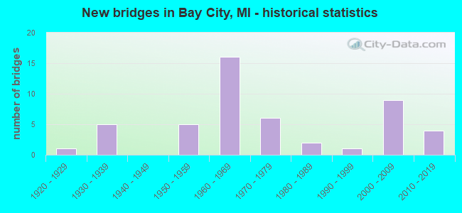
- New bridges - historical statistics
- 11920-1929
- 51930-1939
- 51950-1959
- 161960-1969
- 61970-1979
- 21980-1989
- 11990-1999
- 92000-2009
- 42010-2019
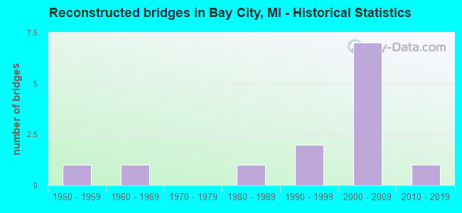
- Reconstructed bridges - Historical Statistics
- 11950-1959
- 11960-1969
- 01970-1979
- 11980-1989
- 21990-1999
- 72000-2009
- 12010-2019
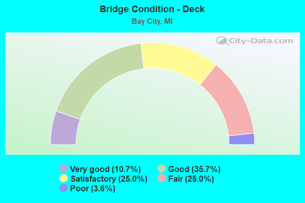
- Bridge Condition - Deck
- 10.7%Very good
- 35.7%Good
- 25.0%Satisfactory
- 25.0%Fair
- 3.6%Poor
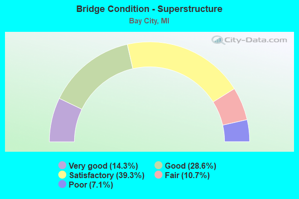
- Bridge Condition - Superstructure
- 14.3%Very good
- 28.6%Good
- 39.3%Satisfactory
- 10.7%Fair
- 7.1%Poor
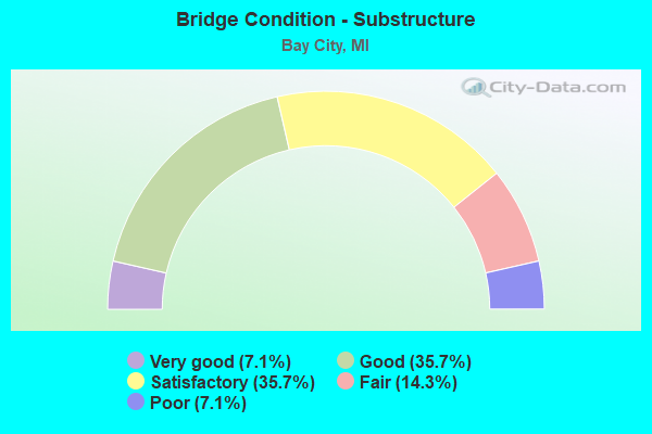
- Bridge Condition - Substructure
- 7.1%Very good
- 35.7%Good
- 35.7%Satisfactory
- 14.3%Fair
- 7.1%Poor
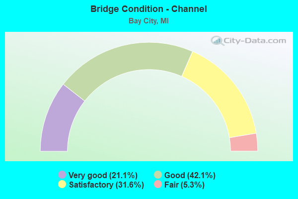
- Bridge Condition - Channel
- 21.1%Very good
- 42.1%Good
- 31.6%Satisfactory
- 5.3%Fair
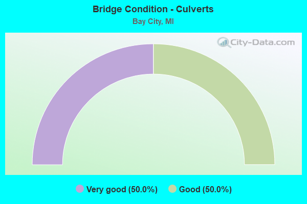
- Bridge Condition - Culverts
- 50.0%Very good
- 50.0%Good
Find on map >> Show street view
Structure Number: 671, Location: 1.0 MI S OF KAWKAWLIN (Lat: 43.638492, Lng: -83.941450), Route carried "under" structure: Ramp Interstate 75, Year Built: 1961, Structure Length: 0. m, Average Daily Traffic: 10,382 (year 2014), Truck Traffic: 4%, Features Intersected: M-13/I-75 CONN, Facility Carried by Structure: WHEELER RD
Minimum Vertical Clearance: 4.47m (14.67ft), Kilometerpoint: 2.773, Lanes on structure: 2, Lanes under structure: 4, Material/Design: Steel, Design/Construction: Stringer/Multi-beam, Length of Maximum Span: 17.9m (58.7ft)
Find on map >> Show street view
Structure Number: 749, Location: IN BAY CITY (Lat: 43.614856, Lng: -83.873025), Route carried "under" structure: City street , Year Built: 1976, Structure Length: 0. m, Features Intersected: SAGINAW RV;MARTIN ST&RR, Facility Carried by Structure: TRUMAN PARKWAY
Minimum Vertical Clearance: 7.01m (23.00ft), Kilometerpoint: 0.156, Lanes on structure: 4, Lanes under structure: 2, Material/Design: Steel, Design/Construction: Movable - Bascule, Length of Maximum Span: 56.4m (185.0ft)
Find on map >> Show street view
Structure Number: 75, Location: IN BAY CITY (Lat: 43.608558, Lng: -83.871717), Route carried "under" structure: City street , Year Built: 1976, Structure Length: 0. m, Average Daily Traffic: 388 (year 2004), Truck Traffic: 4%, Features Intersected: WATER ST & C&ORR, Facility Carried by Structure: TRUMAN PARKWAY
Minimum Vertical Clearance: 7.01m (23.00ft), Kilometerpoint: 1.976, Lanes on structure: 4, Lanes under structure: 2, Material/Design: Steel, Design/Construction: Stringer/Multi-beam, Length of Maximum Span: 31.1m (102.0ft)