Bridge Statistics for Baytown, Texas (TX)
Condition, Traffic, Stress, Structural Evaluation, Project Costs
- National Bridge Inventory (NBI) Statistics
- 159Number of bridges
- 6,939ft / 2,115mTotal length
- $2,476,000Total costs
- 2,951,988Total average daily traffic
- 350,483Total average daily truck traffic
- National Bridge Inventory (NBI) Registered Bridges for Baytown
- No street view available for this location
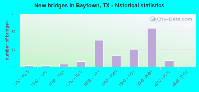
- New bridges - historical statistics
- 21930-1939
- 21940-1949
- 41950-1959
- 81960-1969
- 381970-1979
- 161980-1989
- 241990-1999
- 552000-2009
- 92010-2019
- 12020-2022
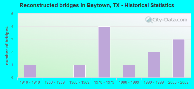
- Reconstructed bridges - Historical Statistics
- 11940-1949
- 01950-1959
- 11960-1969
- 41970-1979
- 11980-1989
- 21990-1999
- 32000-2009
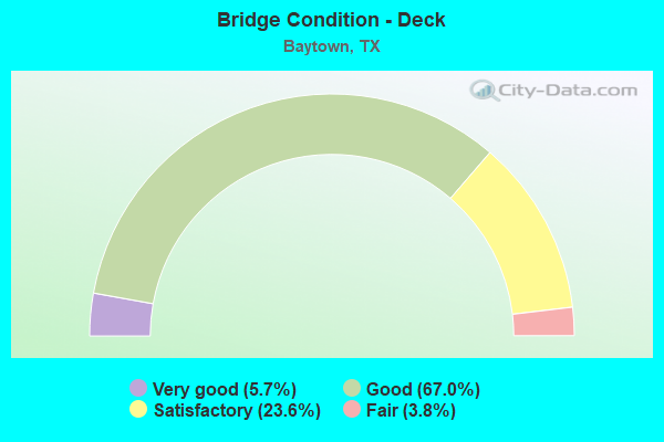
- Bridge Condition - Deck
- 5.7%Very good
- 67.0%Good
- 23.6%Satisfactory
- 3.8%Fair
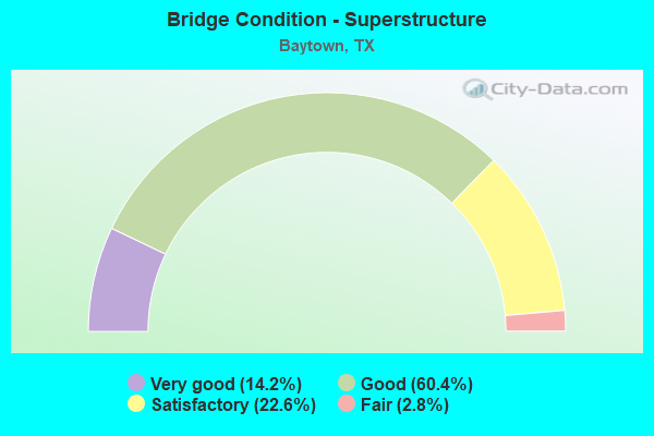
- Bridge Condition - Superstructure
- 14.2%Very good
- 60.4%Good
- 22.6%Satisfactory
- 2.8%Fair
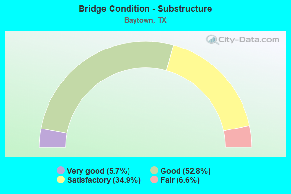
- Bridge Condition - Substructure
- 5.7%Very good
- 52.8%Good
- 34.9%Satisfactory
- 6.6%Fair

- Bridge Condition - Channel
- 8.1%Very good
- 47.7%Good
- 34.9%Satisfactory
- 9.3%Fair
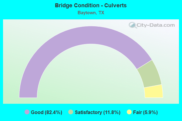
- Bridge Condition - Culverts
- 82.4%Good
- 11.8%Satisfactory
- 5.9%Fair
Find on map >> Show street view
Structure Number: 121020050801337, Location: 1.2 MI E OF SPUR 330 (Lat: 29.797711, Lng: -95.031503), Route carried "on" structure: Interstate 10, Year Built: 2001, Status: Open, Structure Length: 9.21m (30.22ft), Average Daily Traffic: 68,302 (year 2020), Truck Traffic: 20%, Average Future Daily Traffic: 110,540 (year 2033), Design Load: HS 20, Features Intersected: THOMPSON RD
Minimum Vertical Clearance: 30+ m (98+ ft), Kilometerpoint: 77.566, Lanes on structure: 6, Lanes under structure: 6, Owner: State Highway Agency, Approaching Roadway Width: 33.8m (110.9ft), Skew: 32 degrees, Material/Design: Prestressed concrete, Design/Construction: Stringer/Multi-beam, Number Of Spans In Main Unit: 3, Length of Maximum Span: 32.0m (105.0ft), Curb-To-Curb Width: 33.7m (110.6ft), Out-to-Out Width: 35.1m (115.2ft)
Condition: Deck: Good, Superstructure: Good, Substructure: Satisfactory, Operating Rating: 54.4 metric tons, Method Used To Determine Operating Rating: Assigned rating based on Load Factor Design (LFD) reported in metric tons, Inventory Rating: 32.7 metric tons, Method Used To Determine Inventory Rating: Assigned rating based on Load Factor Design (LFD) reported in metric tons, Structural Evaluation: Equal to present minimum criteria, Deck Geometry: Superior to present desirable criteria, Underclear: Meets minimum limits, Approach Roadway Alignment: Equal to present desirable criteria, Length Of Structure Improvement: 5.49m (18.01ft), Designated Inspection Frequency: Every 24 months, Inspection Date: November 2020, Bridge Improvement Cost: $87,000, Roadway Improvement Cost: $22,000, Total Project Cost: $109,000, Deck Structure Type: Concrete Precast Panels
Find on map >> Show street view
Structure Number: 121020050807198, Location: 0.50 MI SE OF IH 10 (Lat: 29.788078, Lng: -95.043197), Route carried "on" structure: ServiceState highway 330, Year Built: 1967, Status: Open, Structure Length: 3.08m (10.10ft), Average Daily Traffic: 9,708 (year 2019), Truck Traffic: 11%, Average Future Daily Traffic: 8,230 (year 2033), Design Load: HS 20, Features Intersected: SPRING GULLY
Minimum Vertical Clearance: 30+ m (98+ ft), Kilometerpoint: 1.086, Lanes on structure: 2, Owner: State Highway Agency, Approaching Roadway Width: 11.6m (38.1ft), Material/Design: Concrete, Design/Construction: Stringer/Multi-beam, Number Of Spans In Main Unit: 1, Number Of Approach Spans: 2, Length of Maximum Span: 12.2m (40.0ft), Curb-To-Curb Width: 10.1m (33.1ft), Out-to-Out Width: 10.9m (35.8ft)
Condition: Deck: Satisfactory, Superstructure: Fair, Substructure: Fair, Channel: Satisfactory, Operating Rating: 44.4 metric tons, Method Used To Determine Operating Rating: Assigned ratings based on Allowable Stress Design (ASD) reported in metric tons, Inventory Rating: 32.7 metric tons, Method Used To Determine Inventory Rating: Assigned ratings based on Allowable Stress Design (ASD) reported in metric tons, Structural Evaluation: Somewhat better than minimum adequacy, Deck Geometry: Somewhat better than minimum adequacy, Waterway Adequacy: Better than present minimum criteria, Approach Roadway Alignment: Equal to present desirable criteria, Length Of Structure Improvement: 3.08m (10.10ft), Designated Inspection Frequency: Every 24 months, Inspection Date: October 2020, Bridge Improvement Cost: $7,000, Roadway Improvement Cost: $2,000, Total Project Cost: $9,000, Deck Structure Type: Concrete Cast-file-Place
Find on map >> Show street view
Structure Number: 12102005080725, Location: 0.30 MI SE OF SH 146 (Lat: 29.744242, Lng: -94.984631), Route carried "on" structure: Spur State highway 330, Year Built: 1979, Status: Open, Structure Length: 6.89m (22.60ft), Average Daily Traffic: 9,290 (year 2020), Truck Traffic: 11%, Average Future Daily Traffic: 15,340 (year 2033), Design Load: HS 20, Features Intersected: GOOSE CREEK
Minimum Vertical Clearance: 30+ m (98+ ft), Kilometerpoint: 8.850, Lanes on structure: 6, Owner: State Highway Agency, Approaching Roadway Width: 21.9m (71.9ft), Skew: 20 degrees, Material/Design: Prestressed concrete, Design/Construction: Box Beam or Girders - Multiple, Number Of Spans In Main Unit: 3, Length of Maximum Span: 22.9m (75.1ft), Curb or Sidewalk Widths: Left: 1.6m (5.2ft), Right: 1.5m (4.9ft), Curb-To-Curb Width: 21.9m (71.9ft), Out-to-Out Width: 30.5m (100.1ft)
Condition: Deck: Very good, Superstructure: Good, Substructure: Good, Channel: Satisfactory, Operating Rating: 54.4 metric tons, Method Used To Determine Operating Rating: Assigned rating based on Load Factor Design (LFD) reported in metric tons, Inventory Rating: 32.7 metric tons, Method Used To Determine Inventory Rating: Assigned rating based on Load Factor Design (LFD) reported in metric tons, Structural Evaluation: Better than present minimum criteria, Deck Geometry: High priority of replacement, Waterway Adequacy: Equal to present minimum criteria, Approach Roadway Alignment: Equal to present desirable criteria, Designated Inspection Frequency: Every 24 months, Underwater Inspection Frequency: Every 60 months, Inspection Date: October 2020, Underwater Inspection Date: December 2017, Deck Structure Type: Concrete Precast Panels, Wearing Surface/Protective System: Wearing Surface: Bituminous
Find on map >> Show street view
Structure Number: 1210200508073, Location: 0.50 MI SE OF IH 10 (Lat: 29.787339, Lng: -95.043308), Route carried "on" structure: ServiceState highway 330, Year Built: 1930, Year Reconstructed: 1948, Status: Posted for load, Structure Length: 1.34m (4.40ft), Average Daily Traffic: 10,146 (year 2019), Truck Traffic: 11%, Average Future Daily Traffic: 12,430 (year 2033), Features Intersected: SPRING GULLY
Minimum Vertical Clearance: 30+ m (98+ ft), Kilometerpoint: 1.107, Lanes on structure: 2, Owner: State Highway Agency, Approaching Roadway Width: 11.0m (36.1ft), Material/Design: Concrete continuous, Design/Construction: Slab, Number Of Spans In Main Unit: 2, Length of Maximum Span: 6.7m (22.0ft), Curb-To-Curb Width: 10.9m (35.8ft), Out-to-Out Width: 15.4m (50.5ft)
Condition: Deck: Fair, Superstructure: Fair, Substructure: Fair, Channel: Fair, Operating Rating: 32.7 metric tons, Method Used To Determine Operating Rating: Field evaluation and documented engineering judgment, Inventory Rating: 24.5 metric tons, Method Used To Determine Inventory Rating: Field evaluation and documented engineering judgment, Structural Evaluation: Somewhat better than minimum adequacy, Deck Geometry: Somewhat better than minimum adequacy, Waterway Adequacy: Better than present minimum criteria, Approach Roadway Alignment: Equal to present desirable criteria, Bridge Posting: Required (Relationship of Operating Rating to Maximum Legal Load: 0.1 - 9.9% below), Length Of Structure Improvement: 1.37m (4.49ft), Designated Inspection Frequency: Every 24 months, Inspection Date: October 2020, Bridge Improvement Cost: $4,000, Roadway Improvement Cost: $1,000, Total Project Cost: $5,000, Deck Structure Type: Concrete Cast-file-Place, Wearing Surface/Protective System: Wearing Surface: Bituminous
Find on map >> Show street view
Structure Number: 121020050807301, Location: 0.4 MI SE OF IH 10 (Lat: 29.787606, Lng: -95.042686), Route carried "on" structure: Spur State highway 330, Year Built: 2004, Status: Open, Structure Length: 10.52m (34.51ft), Average Daily Traffic: 13,390 (year 2013), Truck Traffic: 11%, Average Future Daily Traffic: 18,740 (year 2033), Design Load: HS 20, Features Intersected: Spring Gully
Minimum Vertical Clearance: 30+ m (98+ ft), Kilometerpoint: 1.048, Lanes on structure: 2, Owner: State Highway Agency, Approaching Roadway Width: 13.7m (44.9ft), Skew: 30 degrees, Material/Design: Prestressed concrete, Design/Construction: Stringer/Multi-beam, Number Of Spans In Main Unit: 3, Length of Maximum Span: 35.1m (115.2ft), Curb-To-Curb Width: 13.7m (44.9ft), Out-to-Out Width: 18.1m (59.4ft)
Condition: Deck: Good, Superstructure: Very good, Substructure: Good, Channel: Very good, Operating Rating: 54.4 metric tons, Method Used To Determine Operating Rating: Assigned rating based on Load Factor Design (LFD) reported in metric tons, Inventory Rating: 32.7 metric tons, Method Used To Determine Inventory Rating: Assigned rating based on Load Factor Design (LFD) reported in metric tons, Structural Evaluation: Better than present minimum criteria, Deck Geometry: Superior to present desirable criteria, Waterway Adequacy: Superior to present desirable criteria, Approach Roadway Alignment: Equal to present desirable criteria, Designated Inspection Frequency: Every 24 months, Inspection Date: October 2020, Deck Structure Type: Concrete Precast Panels
Find on map >> Show street view
Structure Number: 121020050807302, Location: 0.4 MI SE OF IH 10 (Lat: 29.787792, Lng: -95.043778), Route carried "on" structure: Spur State highway 330, Year Built: 2004, Status: Open, Structure Length: 10.52m (34.51ft), Average Daily Traffic: 13,390 (year 2013), Truck Traffic: 11%, Average Future Daily Traffic: 18,740 (year 2033), Design Load: HS 20, Features Intersected: Spring Gully
Minimum Vertical Clearance: 30+ m (98+ ft), Kilometerpoint: 1.048, Lanes on structure: 2, Owner: State Highway Agency, Approaching Roadway Width: 13.7m (44.9ft), Skew: 30 degrees, Material/Design: Prestressed concrete, Design/Construction: Stringer/Multi-beam, Number Of Spans In Main Unit: 3, Length of Maximum Span: 35.1m (115.2ft), Curb-To-Curb Width: 13.7m (44.9ft), Out-to-Out Width: 18.1m (59.4ft)
Condition: Deck: Good, Superstructure: Very good, Substructure: Good, Channel: Very good, Operating Rating: 54.4 metric tons, Method Used To Determine Operating Rating: Assigned rating based on Load Factor Design (LFD) reported in metric tons, Inventory Rating: 32.7 metric tons, Method Used To Determine Inventory Rating: Assigned rating based on Load Factor Design (LFD) reported in metric tons, Structural Evaluation: Better than present minimum criteria, Deck Geometry: Superior to present desirable criteria, Waterway Adequacy: Superior to present desirable criteria, Approach Roadway Alignment: Equal to present desirable criteria, Designated Inspection Frequency: Every 24 months, Inspection Date: October 2020, Deck Structure Type: Concrete Precast Panels
Find on map >> Show street view
Structure Number: 121020050807303, Location: 1.10 MI SE OF IH 10 (Lat: 29.783003, Lng: -95.031569), Route carried "on" structure: Spur State highway 330, Year Built: 2003, Status: Open, Structure Length: 10.39m (34.09ft), Average Daily Traffic: 13,390 (year 2013), Truck Traffic: 11%, Average Future Daily Traffic: 18,740 (year 2033), Design Load: HS 20, Features Intersected: BAYWAY DR
Minimum Vertical Clearance: 30+ m (98+ ft), Kilometerpoint: 2.247, Lanes on structure: 3, Lanes under structure: 8, Owner: State Highway Agency, Approaching Roadway Width: 17.7m (58.1ft), Skew: 32 degrees, Material/Design: Prestressed concrete, Design/Construction: Stringer/Multi-beam, Number Of Spans In Main Unit: 3, Length of Maximum Span: 38.7m (127.0ft), Curb-To-Curb Width: 17.1m (56.1ft), Out-to-Out Width: 21.8m (71.5ft)
Condition: Deck: Good, Superstructure: Good, Substructure: Good, Operating Rating: 54.4 metric tons, Method Used To Determine Operating Rating: Assigned rating based on Load Factor Design (LFD) reported in metric tons, Inventory Rating: 32.7 metric tons, Method Used To Determine Inventory Rating: Assigned rating based on Load Factor Design (LFD) reported in metric tons, Structural Evaluation: Better than present minimum criteria, Deck Geometry: Equal to present minimum criteria, Underclear: Superior to present desirable criteria, Approach Roadway Alignment: Equal to present desirable criteria, Designated Inspection Frequency: Every 24 months, Inspection Date: October 2020, Deck Structure Type: Concrete Precast Panels
Find on map >> Show street view
Structure Number: 121020050807304, Location: 1.10 MI SE OF IH 10 (Lat: 29.783056, Lng: -95.032528), Route carried "on" structure: Spur State highway 330, Year Built: 2003, Status: Open, Structure Length: 10.39m (34.09ft), Average Daily Traffic: 13,390 (year 2013), Truck Traffic: 11%, Average Future Daily Traffic: 18,740 (year 2033), Design Load: HS 20, Features Intersected: BAYWAY DR
Minimum Vertical Clearance: 30+ m (98+ ft), Kilometerpoint: 2.247, Lanes on structure: 3, Lanes under structure: 8, Owner: State Highway Agency, Approaching Roadway Width: 17.7m (58.1ft), Skew: 32 degrees, Material/Design: Prestressed concrete, Design/Construction: Stringer/Multi-beam, Number Of Spans In Main Unit: 3, Length of Maximum Span: 38.7m (127.0ft), Curb-To-Curb Width: 17.6m (57.7ft), Out-to-Out Width: 21.8m (71.5ft)
Condition: Deck: Good, Superstructure: Good, Substructure: Good, Operating Rating: 54.4 metric tons, Method Used To Determine Operating Rating: Assigned rating based on Load Factor Design (LFD) reported in metric tons, Inventory Rating: 32.7 metric tons, Method Used To Determine Inventory Rating: Assigned rating based on Load Factor Design (LFD) reported in metric tons, Structural Evaluation: Better than present minimum criteria, Deck Geometry: Better than present minimum criteria, Underclear: Superior to present desirable criteria, Approach Roadway Alignment: Equal to present desirable criteria, Designated Inspection Frequency: Every 24 months, Inspection Date: October 2020, Deck Structure Type: Concrete Precast Panels
Find on map >> Show street view
Structure Number: 121020050807305, Location: 2.5 MI SE OF IH 10 (Lat: 29.769831, Lng: -95.012503), Route carried "on" structure: Spur State highway 330, Year Built: 2003, Status: Open, Structure Length: 91.71m (300.89ft), Average Daily Traffic: 14,950 (year 2013), Truck Traffic: 11%, Average Future Daily Traffic: 20,920 (year 2033), Design Load: HS 20, Features Intersected: MPRR; WADE RD; BAKER RD
Minimum Vertical Clearance: 30+ m (98+ ft), Kilometerpoint: 3.883, Lanes on structure: 3, Lanes under structure: 12, Owner: State Highway Agency, Approaching Roadway Width: 17.7m (58.1ft), Skew: 39 degrees, Material/Design: Prestressed concrete, Design/Construction: Stringer/Multi-beam, Number Of Spans In Main Unit: 27, Length of Maximum Span: 36.6m (120.1ft), Curb-To-Curb Width: 17.6m (57.7ft), Out-to-Out Width: 21.8m (71.5ft)
Condition: Deck: Good, Superstructure: Good, Substructure: Good, Operating Rating: 54.4 metric tons, Method Used To Determine Operating Rating: Assigned rating based on Load Factor Design (LFD) reported in metric tons, Inventory Rating: 32.7 metric tons, Method Used To Determine Inventory Rating: Assigned rating based on Load Factor Design (LFD) reported in metric tons, Structural Evaluation: Better than present minimum criteria, Deck Geometry: Better than present minimum criteria, Underclear: Better than present minimum criteria, Approach Roadway Alignment: Equal to present desirable criteria, Designated Inspection Frequency: Every 24 months, Inspection Date: November 2020, Deck Structure Type: Concrete Precast Panels
Find on map >> Show street view
Structure Number: 121020050807306, Location: 2.50 MI SE OF IH 10 (Lat: 29.773692, Lng: -95.016936), Route carried "on" structure: Spur State highway 330, Year Built: 2003, Status: Open, Structure Length: 91.71m (300.89ft), Average Daily Traffic: 14,950 (year 2013), Truck Traffic: 11%, Average Future Daily Traffic: 20,920 (year 2033), Design Load: HS 20, Features Intersected: MPRR; WADE RD; BAKER RD
Minimum Vertical Clearance: 30+ m (98+ ft), Kilometerpoint: 3.883, Lanes on structure: 3, Lanes under structure: 12, Owner: State Highway Agency, Approaching Roadway Width: 17.7m (58.1ft), Skew: 39 degrees, Material/Design: Prestressed concrete, Design/Construction: Stringer/Multi-beam, Number Of Spans In Main Unit: 27, Length of Maximum Span: 36.6m (120.1ft), Curb-To-Curb Width: 17.4m (57.1ft), Out-to-Out Width: 21.8m (71.5ft)
Condition: Deck: Good, Superstructure: Good, Substructure: Good, Operating Rating: 54.4 metric tons, Method Used To Determine Operating Rating: Assigned rating based on Load Factor Design (LFD) reported in metric tons, Inventory Rating: 32.7 metric tons, Method Used To Determine Inventory Rating: Assigned rating based on Load Factor Design (LFD) reported in metric tons, Structural Evaluation: Better than present minimum criteria, Deck Geometry: Better than present minimum criteria, Underclear: Superior to present desirable criteria, Approach Roadway Alignment: Equal to present desirable criteria, Designated Inspection Frequency: Every 24 months, Inspection Date: November 2020, Deck Structure Type: Concrete Precast Panels
Find on map >> Show street view
Structure Number: 121020050807307, Location: 0.85 MI NW OF SH 146 (Lat: 29.756050, Lng: -94.995886), Route carried "on" structure: Spur State highway 330, Year Built: 2002, Status: Open, Structure Length: 8.93m (29.30ft), Average Daily Traffic: 21,590 (year 2013), Truck Traffic: 11%, Average Future Daily Traffic: 30,220 (year 2033), Design Load: HS 20, Features Intersected: ROLLINGBROOK DRIVE
Minimum Vertical Clearance: 30+ m (98+ ft), Kilometerpoint: 6.960, Lanes on structure: 4, Lanes under structure: 8, Owner: State Highway Agency, Approaching Roadway Width: 21.0m (68.9ft), Material/Design: Prestressed concrete, Design/Construction: Stringer/Multi-beam, Number Of Spans In Main Unit: 3, Length of Maximum Span: 32.0m (105.0ft), Curb-To-Curb Width: 21.0m (68.9ft), Out-to-Out Width: 21.8m (71.5ft)
Condition: Deck: Good, Superstructure: Satisfactory, Substructure: Satisfactory, Operating Rating: 54.4 metric tons, Method Used To Determine Operating Rating: Assigned rating based on Load Factor Design (LFD) reported in metric tons, Inventory Rating: 32.7 metric tons, Method Used To Determine Inventory Rating: Assigned rating based on Load Factor Design (LFD) reported in metric tons, Structural Evaluation: Equal to present minimum criteria, Deck Geometry: Better than present minimum criteria, Underclear: Somewhat better than minimum adequacy, Approach Roadway Alignment: Equal to present desirable criteria, Designated Inspection Frequency: Every 24 months, Inspection Date: September 2020, Deck Structure Type: Concrete Precast Panels
Find on map >> Show street view
Structure Number: 121020050807308, Location: 0.85 MI NW OF SH 146 (Lat: 29.755994, Lng: -94.994947), Route carried "on" structure: Spur State highway 330, Year Built: 2002, Status: Open, Structure Length: 8.93m (29.30ft), Average Daily Traffic: 21,590 (year 2013), Truck Traffic: 11%, Average Future Daily Traffic: 30,220 (year 2033), Design Load: HS 20, Features Intersected: ROLLINGBROOK DRIVE
Minimum Vertical Clearance: 30+ m (98+ ft), Kilometerpoint: 6.960, Lanes on structure: 4, Lanes under structure: 8, Owner: State Highway Agency, Approaching Roadway Width: 21.0m (68.9ft), Material/Design: Prestressed concrete, Design/Construction: Stringer/Multi-beam, Number Of Spans In Main Unit: 3, Length of Maximum Span: 32.0m (105.0ft), Curb-To-Curb Width: 21.0m (68.9ft), Out-to-Out Width: 21.8m (71.5ft)
Condition: Deck: Satisfactory, Superstructure: Satisfactory, Substructure: Fair, Operating Rating: 54.4 metric tons, Method Used To Determine Operating Rating: Assigned rating based on Load Factor Design (LFD) reported in metric tons, Inventory Rating: 32.7 metric tons, Method Used To Determine Inventory Rating: Assigned rating based on Load Factor Design (LFD) reported in metric tons, Structural Evaluation: Somewhat better than minimum adequacy, Deck Geometry: Better than present minimum criteria, Underclear: Somewhat better than minimum adequacy, Approach Roadway Alignment: Equal to present desirable criteria, Designated Inspection Frequency: Every 24 months, Inspection Date: September 2020, Deck Structure Type: Concrete Precast Panels
Find on map >> Show street view
Structure Number: 121020050807309, Location: 3.30 MI SE OF IH 10 (Lat: 29.763044, Lng: -95.006031), Route carried "on" structure: Spur State highway 330, Year Built: 2002, Status: Open, Structure Length: 2.50m (8.20ft), Average Daily Traffic: 21,590 (year 2013), Truck Traffic: 11%, Average Future Daily Traffic: 30,220 (year 2033), Design Load: HS 20, Features Intersected: HCFCD #0107-00-00
Minimum Vertical Clearance: 30+ m (98+ ft), Kilometerpoint: 4.989, Lanes on structure: 3, Owner: State Highway Agency, Approaching Roadway Width: 18.0m (59.1ft), Skew: 4 degrees, Material/Design: Prestressed concrete, Design/Construction: Box Beam or Girders - Multiple, Number Of Spans In Main Unit: 1, Length of Maximum Span: 25.0m (82.0ft), Curb-To-Curb Width: 17.4m (57.1ft), Out-to-Out Width: 18.2m (59.7ft)
Condition: Deck: Good, Superstructure: Very good, Substructure: Very good, Channel: Good, Operating Rating: 54.4 metric tons, Method Used To Determine Operating Rating: Assigned rating based on Load Factor Design (LFD) reported in metric tons, Inventory Rating: 32.7 metric tons, Method Used To Determine Inventory Rating: Assigned rating based on Load Factor Design (LFD) reported in metric tons, Structural Evaluation: Equal to present desirable criteria, Deck Geometry: Better than present minimum criteria, Waterway Adequacy: Superior to present desirable criteria, Approach Roadway Alignment: Equal to present desirable criteria, Designated Inspection Frequency: Every 24 months, Inspection Date: November 2020, Deck Structure Type: Concrete Cast-file-Place
Find on map >> Show street view
Structure Number: 12102005080731, Location: 3.30 MI SE OF IH 10 (Lat: 29.763161, Lng: -95.005550), Route carried "on" structure: Spur State highway 330, Year Built: 2002, Status: Open, Structure Length: 2.50m (8.20ft), Average Daily Traffic: 21,590 (year 2013), Truck Traffic: 11%, Average Future Daily Traffic: 30,220 (year 2033), Design Load: HS 20, Features Intersected: HCFCD #0107-00-00
Minimum Vertical Clearance: 30+ m (98+ ft), Kilometerpoint: 4.897, Lanes on structure: 5, Owner: State Highway Agency, Approaching Roadway Width: 28.7m (94.2ft), Skew: 4 degrees, Material/Design: Prestressed concrete, Design/Construction: Box Beam or Girders - Multiple, Number Of Spans In Main Unit: 1, Length of Maximum Span: 25.0m (82.0ft), Curb-To-Curb Width: 28.0m (91.9ft), Out-to-Out Width: 30.6m (100.4ft)
Condition: Deck: Good, Superstructure: Good, Substructure: Good, Channel: Good, Operating Rating: 54.4 metric tons, Method Used To Determine Operating Rating: Assigned rating based on Load Factor Design (LFD) reported in metric tons, Inventory Rating: 32.7 metric tons, Method Used To Determine Inventory Rating: Assigned rating based on Load Factor Design (LFD) reported in metric tons, Structural Evaluation: Better than present minimum criteria, Deck Geometry: Superior to present desirable criteria, Waterway Adequacy: Superior to present desirable criteria, Approach Roadway Alignment: Equal to present desirable criteria, Designated Inspection Frequency: Every 24 months, Inspection Date: November 2020, Deck Structure Type: Concrete Cast-file-Place
Find on map >> Show street view
Structure Number: 121020050807311, Location: 3.30 MI SE OF IH 10 (Lat: 29.763025, Lng: -95.006231), Route carried "on" structure: ServiceState highway 330, Year Built: 2002, Status: Open, Structure Length: 2.26m (7.41ft), Average Daily Traffic: 3,822 (year 2019), Truck Traffic: 9%, Average Future Daily Traffic: 4,150 (year 2033), Design Load: HS 20, Features Intersected: HCFCD #0107-00-00
Minimum Vertical Clearance: 30+ m (98+ ft), Kilometerpoint: 4.989, Lanes on structure: 3, Owner: State Highway Agency, Approaching Roadway Width: 11.0m (36.1ft), Skew: 4 degrees, Material/Design: Prestressed concrete, Design/Construction: Box Beam or Girders - Multiple, Number Of Spans In Main Unit: 1, Length of Maximum Span: 22.6m (74.1ft), Curb or Sidewalk Widths: Left: 0.0m, Right: 1.8m (5.9ft), Curb-To-Curb Width: 11.0m (36.1ft), Out-to-Out Width: 14.0m (45.9ft)
Condition: Deck: Good, Superstructure: Very good, Substructure: Good, Channel: Good, Operating Rating: 54.4 metric tons, Method Used To Determine Operating Rating: Assigned rating based on Load Factor Design (LFD) reported in metric tons, Inventory Rating: 32.7 metric tons, Method Used To Determine Inventory Rating: Assigned rating based on Load Factor Design (LFD) reported in metric tons, Structural Evaluation: Better than present minimum criteria, Deck Geometry: High priority of replacement, Waterway Adequacy: Superior to present desirable criteria, Approach Roadway Alignment: Equal to present desirable criteria, Designated Inspection Frequency: Every 24 months, Inspection Date: November 2020, Deck Structure Type: Concrete Cast-file-Place
Find on map >> Show street view
Structure Number: 121020050807312, Location: 3.30 MI SE OF IH 10 (Lat: 29.763122, Lng: -95.005514), Route carried "on" structure: ServiceState highway 330, Year Built: 2002, Status: Open, Structure Length: 2.35m (7.71ft), Average Daily Traffic: 5,676 (year 2019), Truck Traffic: 9%, Average Future Daily Traffic: 4,270 (year 2033), Design Load: HS 20, Features Intersected: HCFCD #0107-00-00
Minimum Vertical Clearance: 30+ m (98+ ft), Kilometerpoint: 4.897, Lanes on structure: 1, Owner: State Highway Agency, Approaching Roadway Width: 7.3m (24.0ft), Skew: 4 degrees, Material/Design: Prestressed concrete, Design/Construction: Box Beam or Girders - Multiple, Number Of Spans In Main Unit: 1, Length of Maximum Span: 23.5m (77.1ft), Curb or Sidewalk Widths: Left: 1.8m (5.9ft), Right: 0.0m, Curb-To-Curb Width: 7.4m (24.3ft), Out-to-Out Width: 10.5m (34.4ft)
Condition: Deck: Good, Superstructure: Very good, Substructure: Good, Channel: Very good, Operating Rating: 54.4 metric tons, Method Used To Determine Operating Rating: Assigned rating based on Load Factor Design (LFD) reported in metric tons, Inventory Rating: 32.7 metric tons, Method Used To Determine Inventory Rating: Assigned rating based on Load Factor Design (LFD) reported in metric tons, Structural Evaluation: Better than present minimum criteria, Deck Geometry: High priority of replacement, Waterway Adequacy: Superior to present desirable criteria, Approach Roadway Alignment: Equal to present desirable criteria, Designated Inspection Frequency: Every 24 months, Inspection Date: November 2020, Deck Structure Type: Concrete Cast-file-Place
Find on map >> Show street view
Structure Number: 121020050807339, Location: 3.75 MI SE OF IH 10 (Lat: 29.758853, Lng: -95.000294), Route carried "on" structure: Spur State highway 330, Year Built: 2002, Status: Open, Structure Length: 0.76m (2.49ft), Average Daily Traffic: 15,000 (year 2010), Truck Traffic: 8%, Average Future Daily Traffic: 25,000 (year 2030), Features Intersected: HCFCD #0107-02-00
Minimum Vertical Clearance: 30+ m (98+ ft), Kilometerpoint: 6.333, Lanes on structure: 13, Owner: State Highway Agency, Approaching Roadway Width: 54.9m (180.1ft), Skew: 31 degrees, Material/Design: Concrete, Design/Construction: Culvert, Number Of Spans In Main Unit: 2, Length of Maximum Span: 3.0m (9.8ft)
Condition: Channel: Good, Culverts: Good, Operating Rating: 32.7 metric tons, Method Used To Determine Operating Rating: Field evaluation and documented engineering judgment, Inventory Rating: 24.5 metric tons, Method Used To Determine Inventory Rating: Field evaluation and documented engineering judgment, Structural Evaluation: Equal to present minimum criteria, Waterway Adequacy: Superior to present desirable criteria, Approach Roadway Alignment: Equal to present desirable criteria, Designated Inspection Frequency: Every 24 months, Inspection Date: December 2020
Find on map >> Show street view
Structure Number: 12102005080734, Location: 1.80 MI SE OF IH 10 (Lat: 29.776800, Lng: -95.019081), Route carried "on" structure: Spur State highway 330, Year Built: 2002, Status: Open, Structure Length: 1.01m (3.31ft), Average Daily Traffic: 35,331 (year 2020), Truck Traffic: 8%, Average Future Daily Traffic: 24,500 (year 2030), Features Intersected: HCFCD #0111-00-00
Minimum Vertical Clearance: 30+ m (98+ ft), Kilometerpoint: 4.305, Lanes on structure: 9, Owner: State Highway Agency, Approaching Roadway Width: 58.5m (191.9ft), Skew: 33 degrees, Material/Design: Concrete, Design/Construction: Culvert, Number Of Spans In Main Unit: 3, Length of Maximum Span: 2.4m (7.9ft)
Condition: Channel: Satisfactory, Culverts: Good, Operating Rating: 32.7 metric tons, Method Used To Determine Operating Rating: Field evaluation and documented engineering judgment, Inventory Rating: 24.5 metric tons, Method Used To Determine Inventory Rating: Field evaluation and documented engineering judgment, Structural Evaluation: Equal to present minimum criteria, Waterway Adequacy: Superior to present desirable criteria, Approach Roadway Alignment: Equal to present desirable criteria, Designated Inspection Frequency: Every 24 months, Inspection Date: December 2020
Find on map >> Show street view
Structure Number: 121020050807343, Location: 0.45 MI NW OF SH 146 (Lat: 29.751611, Lng: -94.989239), Route carried "on" structure: Ramp State highway 330, Year Built: 2002, Status: Open, Structure Length: 8.63m (28.31ft), Average Daily Traffic: 5,500 (year 2012), Truck Traffic: 11%, Average Future Daily Traffic: 7,500 (year 2032), Design Load: HS 20, Features Intersected: SPUR 330 WB
Minimum Vertical Clearance: 30+ m (98+ ft), Kilometerpoint: 77.907, Lanes on structure: 1, Lanes under structure: 2, Owner: State Highway Agency, Approaching Roadway Width: 7.9m (25.9ft), Material/Design: Prestressed concrete, Design/Construction: Stringer/Multi-beam, Number Of Spans In Main Unit: 2, Number Of Approach Spans: 1, Length of Maximum Span: 34.7m (113.8ft), Curb-To-Curb Width: 7.9m (25.9ft), Out-to-Out Width: 8.8m (28.9ft)
Condition: Deck: Good, Superstructure: Satisfactory, Substructure: Satisfactory, Operating Rating: 54.4 metric tons, Method Used To Determine Operating Rating: Assigned rating based on Load Factor Design (LFD) reported in metric tons, Inventory Rating: 32.7 metric tons, Method Used To Determine Inventory Rating: Assigned rating based on Load Factor Design (LFD) reported in metric tons, Structural Evaluation: Equal to present minimum criteria, Deck Geometry: Equal to present desirable criteria, Underclear: High priority of corrective action, Approach Roadway Alignment: Equal to present desirable criteria, Designated Inspection Frequency: Every 24 months, Inspection Date: September 2020, Deck Structure Type: Concrete Precast Panels
Find on map >> Show street view
Structure Number: 121020181201005, Location: 2.2 MI W OF CHAMBERS C/L (Lat: 29.843769, Lng: -94.983106), Route carried "on" structure: State highway 1942, Year Built: 1973, Status: Posted for load, Structure Length: 3.11m (10.20ft), Average Daily Traffic: 9,139 (year 2016), Truck Traffic: 9%, Average Future Daily Traffic: 13,860 (year 2033), Features Intersected: LYNCHBURG RESERVOIR CAN
Minimum Vertical Clearance: 30+ m (98+ ft), Kilometerpoint: 10.898, Lanes on structure: 2, Owner: State Highway Agency, Approaching Roadway Width: 11.6m (38.1ft), Material/Design: Concrete, Design/Construction: Stringer/Multi-beam, Number Of Spans In Main Unit: 3, Length of Maximum Span: 12.2m (40.0ft), Curb-To-Curb Width: 14.6m (47.9ft), Out-to-Out Width: 15.3m (50.2ft)
Condition: Deck: Good, Superstructure: Good, Substructure: Satisfactory, Channel: Good, Operating Rating: 32.7 metric tons, Method Used To Determine Operating Rating: Field evaluation and documented engineering judgment, Inventory Rating: 24.5 metric tons, Method Used To Determine Inventory Rating: Field evaluation and documented engineering judgment, Structural Evaluation: Equal to present minimum criteria, Deck Geometry: Superior to present desirable criteria, Waterway Adequacy: Superior to present desirable criteria, Approach Roadway Alignment: Equal to present minimum criteria, Bridge Posting: Required (Relationship of Operating Rating to Maximum Legal Load: 0.1 - 9.9% below), Designated Inspection Frequency: Every 24 months, Inspection Date: November 2020, Deck Structure Type: Concrete Cast-file-Place, Wearing Surface/Protective System: Wearing Surface: Bituminous
Find on map >> Show street view
Structure Number: 121020318701002, Location: SH 99 / Cedar Bayou (Lat: 29.720333, Lng: -94.939008), Route carried "on" structure: State highway 99, Year Built: 2020, Status: Open, Structure Length: 110.15m (361.38ft), Average Daily Traffic: 11,500 (year 2014), Truck Traffic: 10%, Average Future Daily Traffic: 1 (year 1900), Design Load: HL 93, Features Intersected: Cedar Bayou
Minimum Vertical Clearance: 30+ m (98+ ft), Kilometerpoint: 1.609, Lanes on structure: 1, Base Highway Network: Yes, Owner: State Highway Agency, Approaching Roadway Width: 11.6m (38.1ft), Skew: 9 degrees, Navigation Control: Yes ( Vertical Clearance: 17.4m (57.1ft), Horizontal Clearance: 45.7m (149.9ft)), Material/Design: Steel continuous, Design/Construction: Stringer/Multi-beam, Number Of Spans In Main Unit: 3, Number Of Approach Spans: 28, Length of Maximum Span: 85.3m (279.9ft), Curb-To-Curb Width: 11.5m (37.7ft), Out-to-Out Width: 12.3m (40.4ft)
Condition: Deck: Very good, Superstructure: Very good, Substructure: Very good, Channel: Very good, Operating Rating: 54.4 metric tons, Method Used To Determine Operating Rating: Assigned ratings based on Load and Resistance Factor Design (LRFD) reported in metric tons, Inventory Rating: 32.7 metric tons, Method Used To Determine Inventory Rating: Assigned ratings based on Load and Resistance Factor Design (LRFD) reported in metric tons, Structural Evaluation: Equal to present desirable criteria, Deck Geometry: Meets minimum limits, Waterway Adequacy: Superior to present desirable criteria, Approach Roadway Alignment: Equal to present desirable criteria, Designated Inspection Frequency: Every 24 months, Inspection Date: Febuary 2021, Deck Structure Type: Corrugated Steel
Find on map >> Show street view
Structure Number: 121020AA0830001, Location: 0.30 MI S OF ALEXANDER (Lat: 29.753608, Lng: -94.928556), Route carried "on" structure: County highway , Year Built: 1991, Status: Posted for load, Structure Length: 0.82m (2.69ft), Average Daily Traffic: 400 (year 2015), Truck Traffic: 1%, Average Future Daily Traffic: 1,000 (year 2035), Features Intersected: POND GULLY, Facility Carried by Structure: FERRY RD
Minimum Vertical Clearance: 30+ m (98+ ft), Kilometerpoint: 0.805, Lanes on structure: 2, Owner: County Highway Agency, Approaching Roadway Width: 7.3m (24.0ft), Material/Design: Prestressed concrete, Number Of Spans In Main Unit: 1, Length of Maximum Span: 7.6m (24.9ft), Curb or Sidewalk Widths: Left: 1.2m (3.9ft), Right: 1.2m (3.9ft), Curb-To-Curb Width: 8.5m (27.9ft), Out-to-Out Width: 11.6m (38.1ft)
Condition: Deck: Good, Superstructure: Very good, Substructure: Very good, Channel: Good, Operating Rating: 32.7 metric tons, Method Used To Determine Operating Rating: Field evaluation and documented engineering judgment, Inventory Rating: 24.5 metric tons, Method Used To Determine Inventory Rating: Field evaluation and documented engineering judgment, Structural Evaluation: Equal to present minimum criteria, Deck Geometry: Equal to present minimum criteria, Waterway Adequacy: Better than present minimum criteria, Approach Roadway Alignment: Equal to present desirable criteria, Bridge Posting: Required (Relationship of Operating Rating to Maximum Legal Load: 0.1 - 9.9% below), Designated Inspection Frequency: Every 24 months, Inspection Date: August 2021, Deck Structure Type: Concrete Cast-file-Place
Find on map >> Show street view
Structure Number: 121020AA1880001, Location: 0.1 MI E OF SPUR 330 (Lat: 29.745597, Lng: -94.983292), Route carried "on" structure: County highway , Year Built: 1991, Status: Open, Structure Length: 6.40m (21.00ft), Average Daily Traffic: 2,200 (year 2015), Average Future Daily Traffic: 2,600 (year 2035), Features Intersected: GOOSE CREEK, Facility Carried by Structure: PARK ST
Minimum Vertical Clearance: 30+ m (98+ ft), Kilometerpoint: 0.161, Lanes on structure: 2, Owner: County Highway Agency, Approaching Roadway Width: 11.0m (36.1ft), Skew: 9 degrees, Material/Design: Prestressed concrete, Design/Construction: Box Beam or Girders - Multiple, Number Of Spans In Main Unit: 5, Length of Maximum Span: 12.8m (42.0ft), Curb-To-Curb Width: 12.2m (40.0ft), Out-to-Out Width: 13.1m (43.0ft)
Condition: Deck: Good, Superstructure: Satisfactory, Substructure: Good, Channel: Good, Operating Rating: 32.7 metric tons, Method Used To Determine Operating Rating: Field evaluation and documented engineering judgment, Inventory Rating: 24.5 metric tons, Method Used To Determine Inventory Rating: Field evaluation and documented engineering judgment, Structural Evaluation: Equal to present minimum criteria, Deck Geometry: Equal to present minimum criteria, Waterway Adequacy: Better than present minimum criteria, Approach Roadway Alignment: Equal to present desirable criteria, Designated Inspection Frequency: Every 24 months, Inspection Date: August 2021, Deck Structure Type: Concrete Cast-file-Place
Find on map >> Show street view
Structure Number: 121020AA2505001, Location: 0.2 MI SE OF LP 201 (Lat: 29.722878, Lng: -94.989575), Route carried "on" structure: County highway , Year Built: 1994, Status: Open, Structure Length: 19.17m (62.89ft), Average Daily Traffic: 3,805 (year 2015), Average Future Daily Traffic: 8,400 (year 2035), Design Load: HS 20, Features Intersected: GOOSE CRK, Facility Carried by Structure: WEST MAIN ST
Minimum Vertical Clearance: 30+ m (98+ ft), Kilometerpoint: 9.431, Lanes on structure: 2, Owner: County Highway Agency, Approaching Roadway Width: 7.3m (24.0ft), Material/Design: Prestressed concrete, Design/Construction: Box Beam or Girders - Multiple, Number Of Spans In Main Unit: 8, Number Of Approach Spans: 1, Length of Maximum Span: 23.2m (76.1ft), Curb or Sidewalk Widths: Left: 1.8m (5.9ft), Right: 0.0m, Curb-To-Curb Width: 13.4m (44.0ft), Out-to-Out Width: 16.4m (53.8ft)
Condition: Deck: Good, Superstructure: Good, Substructure: Good, Channel: Satisfactory, Operating Rating: 54.4 metric tons, Method Used To Determine Operating Rating: Assigned rating based on Load Factor Design (LFD) reported in metric tons, Inventory Rating: 32.7 metric tons, Method Used To Determine Inventory Rating: Assigned rating based on Load Factor Design (LFD) reported in metric tons, Structural Evaluation: Better than present minimum criteria, Deck Geometry: Better than present minimum criteria, Waterway Adequacy: Superior to present desirable criteria, Approach Roadway Alignment: Equal to present desirable criteria, Length Of Structure Improvement: 19.14m (62.80ft), Designated Inspection Frequency: Every 24 months, Underwater Inspection Frequency: Every 60 months, Inspection Date: September 2021, Underwater Inspection Date: May 2020, Deck Structure Type: Concrete Cast-file-Place
Find on map >> Show street view
Structure Number: 121020AA3300001, Location: 0.3 MI S OF SH 99 (Lat: 29.715656, Lng: -94.953519), Route carried "on" structure: County highway , Year Built: 1965, Year Reconstructed: 1970, Status: Posted for load, Structure Length: 1.31m (4.30ft), Average Daily Traffic: 1,080 (year 2015), Average Future Daily Traffic: 1,280 (year 2035), Features Intersected: PINE GULLY, Facility Carried by Structure: TRI-CITY BEACH RD
Minimum Vertical Clearance: 30+ m (98+ ft), Kilometerpoint: 1.368, Lanes on structure: 2, Owner: Town or Township Highway Agency, Approaching Roadway Width: 7.3m (24.0ft), Material/Design: Concrete, Design/Construction: Slab, Number Of Spans In Main Unit: 2, Length of Maximum Span: 6.1m (20.0ft), Curb-To-Curb Width: 7.3m (24.0ft), Out-to-Out Width: 10.6m (34.8ft)
Condition: Deck: Fair, Superstructure: Fair, Substructure: Fair, Channel: Satisfactory, Operating Rating: 32.7 metric tons, Method Used To Determine Operating Rating: Field evaluation and documented engineering judgment, Inventory Rating: 24.5 metric tons, Method Used To Determine Inventory Rating: Field evaluation and documented engineering judgment, Structural Evaluation: Somewhat better than minimum adequacy, Deck Geometry: Meets minimum limits, Waterway Adequacy: Better than present minimum criteria, Approach Roadway Alignment: Equal to present desirable criteria, Designated Inspection Frequency: Every 24 months, Inspection Date: August 2021, Deck Structure Type: Concrete Cast-file-Place, Wearing Surface/Protective System: Wearing Surface: Bituminous
Find on map >> Show street view
Structure Number: 121020AA3300002, Location: 1.5 MI S OF SP 55 (Lat: 29.701867, Lng: -94.943872), Route carried "on" structure: County highway , Year Built: 1975, Status: Posted for load, Structure Length: 10.45m (34.28ft), Average Daily Traffic: 1,050 (year 2015), Average Future Daily Traffic: 1,250 (year 2035), Features Intersected: HL&P CANAL, Facility Carried by Structure: TRI-CITY BEACH RD
Minimum Vertical Clearance: 30+ m (98+ ft), Kilometerpoint: 3.219, Lanes on structure: 2, Owner: County Highway Agency, Approaching Roadway Width: 6.7m (22.0ft), Skew: 1 degrees, Material/Design: Concrete, Design/Construction: Stringer/Multi-beam, Number Of Spans In Main Unit: 11, Length of Maximum Span: 9.4m (30.8ft), Curb-To-Curb Width: 10.1m (33.1ft), Out-to-Out Width: 11.0m (36.1ft)
Condition: Deck: Satisfactory, Superstructure: Satisfactory, Substructure: Satisfactory, Channel: Good, Operating Rating: 32.7 metric tons, Method Used To Determine Operating Rating: Field evaluation and documented engineering judgment, Inventory Rating: 24.5 metric tons, Method Used To Determine Inventory Rating: Field evaluation and documented engineering judgment, Structural Evaluation: Equal to present minimum criteria, Deck Geometry: Somewhat better than minimum adequacy, Waterway Adequacy: Better than present minimum criteria, Approach Roadway Alignment: Equal to present desirable criteria, Bridge Posting: Required (Relationship of Operating Rating to Maximum Legal Load: 0.1 - 9.9% below), Length Of Structure Improvement: 10.45m (34.28ft), Designated Inspection Frequency: Every 24 months, Underwater Inspection Frequency: Every 60 months, Inspection Date: August 2021, Underwater Inspection Date: June 2018, Total Project Cost: $192,000, Deck Structure Type: Concrete Cast-file-Place
Find on map >> Show street view
Structure Number: 121020AA3347001, Location: 0.35 MI N OF MASSEY TOMKI (Lat: 29.772142, Lng: -94.928300), Route carried "on" structure: County highway , Year Built: 1967, Status: Posted for load, Structure Length: 2.77m (9.09ft), Average Daily Traffic: 4,290 (year 2012), Average Future Daily Traffic: 5,000 (year 2035), Features Intersected: CARY BAYOU, Facility Carried by Structure: RACOON DR
Minimum Vertical Clearance: 30+ m (98+ ft), Kilometerpoint: 0.161, Lanes on structure: 2, Owner: County Highway Agency, Approaching Roadway Width: 11.0m (36.1ft), Material/Design: Concrete, Design/Construction: Stringer/Multi-beam, Number Of Spans In Main Unit: 3, Length of Maximum Span: 9.1m (29.9ft), Curb or Sidewalk Widths: Left: 1.6m (5.2ft), Right: 1.5m (4.9ft), Curb-To-Curb Width: 11.0m (36.1ft), Out-to-Out Width: 15.3m (50.2ft)
Condition: Deck: Satisfactory, Superstructure: Satisfactory, Substructure: Satisfactory, Channel: Satisfactory, Operating Rating: 32.7 metric tons, Method Used To Determine Operating Rating: Field evaluation and documented engineering judgment, Inventory Rating: 24.5 metric tons, Method Used To Determine Inventory Rating: Field evaluation and documented engineering judgment, Structural Evaluation: Equal to present minimum criteria, Deck Geometry: Somewhat better than minimum adequacy, Waterway Adequacy: Better than present minimum criteria, Approach Roadway Alignment: Equal to present desirable criteria, Bridge Posting: Required (Relationship of Operating Rating to Maximum Legal Load: 0.1 - 9.9% below), Designated Inspection Frequency: Every 24 months, Inspection Date: August 2021, Deck Structure Type: Concrete Cast-file-Place, Wearing Surface/Protective System: Wearing Surface: Bituminous
Find on map >> Show street view
Structure Number: 121020AA3353001, Location: 0.35 MI E OF GARTH RD (Lat: 29.777372, Lng: -94.971664), Route carried "on" structure: County highway , Year Built: 1994, Status: Open, Structure Length: 1.89m (6.20ft), Average Daily Traffic: 14,219 (year 2016), Truck Traffic: 5%, Average Future Daily Traffic: 10,000 (year 2033), Features Intersected: E.FORK GOOSE CRK, Facility Carried by Structure: CEDAR BYU LYCHBURG
Minimum Vertical Clearance: 30+ m (98+ ft), Kilometerpoint: 6.759, Lanes on structure: 5, Owner: County Highway Agency, Approaching Roadway Width: 18.3m (60.0ft), Material/Design: Prestressed concrete, Design/Construction: Box Beam or Girders - Multiple, Number Of Spans In Main Unit: 1, Length of Maximum Span: 18.3m (60.0ft), Curb or Sidewalk Widths: Left: 2.0m (6.6ft), Right: 2.0m (6.6ft), Curb-To-Curb Width: 18.3m (60.0ft), Out-to-Out Width: 22.9m (75.1ft)
Condition: Deck: Good, Superstructure: Very good, Substructure: Good, Channel: Satisfactory, Operating Rating: 32.7 metric tons, Method Used To Determine Operating Rating: Field evaluation and documented engineering judgment, Inventory Rating: 24.5 metric tons, Method Used To Determine Inventory Rating: Field evaluation and documented engineering judgment, Structural Evaluation: Equal to present minimum criteria, Deck Geometry: High priority of replacement, Waterway Adequacy: Better than present minimum criteria, Approach Roadway Alignment: Equal to present desirable criteria, Designated Inspection Frequency: Every 24 months, Inspection Date: August 2021, Deck Structure Type: Concrete Cast-file-Place
Find on map >> Show street view
Structure Number: 121020AA3353002, Location: 0.85 MI E OF WADE RD (Lat: 29.782275, Lng: -95.002517), Route carried "on" structure: County highway , Year Built: 1978, Status: Open, Structure Length: 2.53m (8.30ft), Average Daily Traffic: 7,184 (year 2016), Truck Traffic: 2%, Average Future Daily Traffic: 5,500 (year 2029), Design Load: HS 20, Features Intersected: GOOSE CRK, Facility Carried by Structure: CEDAR BYU LYCHBURG
Minimum Vertical Clearance: 30+ m (98+ ft), Kilometerpoint: 3.782, Lanes on structure: 2, Owner: County Highway Agency, Approaching Roadway Width: 6.7m (22.0ft), Material/Design: Prestressed concrete, Design/Construction: Box Beam or Girders - Multiple, Number Of Spans In Main Unit: 3, Length of Maximum Span: 8.2m (26.9ft), Curb-To-Curb Width: 8.8m (28.9ft), Out-to-Out Width: 9.4m (30.8ft)
Condition: Deck: Good, Superstructure: Good, Substructure: Good, Channel: Good, Operating Rating: 54.4 metric tons, Method Used To Determine Operating Rating: Assigned rating based on Load Factor Design (LFD) reported in metric tons, Inventory Rating: 32.7 metric tons, Method Used To Determine Inventory Rating: Assigned rating based on Load Factor Design (LFD) reported in metric tons, Structural Evaluation: Better than present minimum criteria, Deck Geometry: High priority of replacement, Waterway Adequacy: Better than present minimum criteria, Approach Roadway Alignment: Equal to present desirable criteria, Length Of Structure Improvement: 2.53m (8.30ft), Designated Inspection Frequency: Every 24 months, Inspection Date: August 2021, Bridge Improvement Cost: $4,000, Roadway Improvement Cost: $1,000, Total Project Cost: $5,000, Deck Structure Type: Concrete Cast-file-Place, Wearing Surface/Protective System: Wearing Surface: Bituminous
Find on map >> Show street view
Structure Number: 121020AA3362001, Location: .25MI E OF SJOLANDER RD (Lat: 29.810903, Lng: -94.933881), Route carried "on" structure: County highway , Year Built: 1992, Status: Open, Structure Length: 1.28m (4.20ft), Average Daily Traffic: 300 (year 2012), Average Future Daily Traffic: 400 (year 2032), Features Intersected: MCGEE GULLY, Facility Carried by Structure: NEEDLEPOINT RD
Minimum Vertical Clearance: 30+ m (98+ ft), Kilometerpoint: 0.402, Lanes on structure: 2, Owner: County Highway Agency, Approaching Roadway Width: 6.1m (20.0ft), Material/Design: Prestressed concrete, Design/Construction: Box Beam or Girders - Multiple, Number Of Spans In Main Unit: 1, Length of Maximum Span: 12.5m (41.0ft), Curb or Sidewalk Widths: Left: 1.2m (3.9ft), Right: 1.2m (3.9ft), Curb-To-Curb Width: 7.3m (24.0ft), Out-to-Out Width: 10.4m (34.1ft)
Condition: Deck: Good, Superstructure: Very good, Substructure: Good, Channel: Good, Operating Rating: 32.7 metric tons, Method Used To Determine Operating Rating: Field evaluation and documented engineering judgment, Inventory Rating: 24.5 metric tons, Method Used To Determine Inventory Rating: Field evaluation and documented engineering judgment, Structural Evaluation: Equal to present minimum criteria, Deck Geometry: Somewhat better than minimum adequacy, Waterway Adequacy: Better than present minimum criteria, Approach Roadway Alignment: Equal to present desirable criteria, Length Of Structure Improvement: 1.28m (4.20ft), Designated Inspection Frequency: Every 24 months, Inspection Date: August 2021, Bridge Improvement Cost: $2,000, Roadway Improvement Cost: $1,000, Total Project Cost: $3,000, Deck Structure Type: Concrete Cast-file-Place
Find on map >> Show street view
Structure Number: 121020AA3371001, Location: 1.40 MI W OF GARTH RD (Lat: 29.770822, Lng: -95.000047), Route carried "on" structure: County highway , Year Built: 1972, Status: Open, Structure Length: 3.78m (12.40ft), Average Daily Traffic: 7,960 (year 2013), Average Future Daily Traffic: 10,000 (year 2033), Features Intersected: GOOSE CREEK, Facility Carried by Structure: BAKER RD EB
Minimum Vertical Clearance: 30+ m (98+ ft), Kilometerpoint: 2.977, Lanes on structure: 2, Owner: County Highway Agency, Approaching Roadway Width: 7.3m (24.0ft), Skew: 1 degrees, Material/Design: Prestressed concrete, Design/Construction: Box Beam or Girders - Multiple, Number Of Spans In Main Unit: 3, Length of Maximum Span: 12.2m (40.0ft), Curb or Sidewalk Widths: Left: 1.3m (4.3ft), Right: 0.0m, Curb-To-Curb Width: 7.3m (24.0ft), Out-to-Out Width: 10.4m (34.1ft)
Condition: Deck: Satisfactory, Superstructure: Good, Substructure: Good, Channel: Satisfactory, Operating Rating: 32.7 metric tons, Method Used To Determine Operating Rating: Field evaluation and documented engineering judgment, Inventory Rating: 24.5 metric tons, Method Used To Determine Inventory Rating: Field evaluation and documented engineering judgment, Structural Evaluation: Equal to present minimum criteria, Deck Geometry: High priority of replacement, Waterway Adequacy: Better than present minimum criteria, Approach Roadway Alignment: Equal to present desirable criteria, Length Of Structure Improvement: 3.78m (12.40ft), Designated Inspection Frequency: Every 24 months, Inspection Date: August 2021, Bridge Improvement Cost: $6,000, Roadway Improvement Cost: $2,000, Total Project Cost: $8,000, Deck Structure Type: Concrete Cast-file-Place
Find on map >> Show street view
Structure Number: 121020AA3371002, Location: 1.40 MI W OF GARTH RD (Lat: 29.770969, Lng: -94.999994), Route carried "on" structure: County highway , Year Built: 1980, Status: Posted for load, Structure Length: 3.78m (12.40ft), Average Daily Traffic: 7,960 (year 2012), Average Future Daily Traffic: 10,000 (year 2032), Features Intersected: GOOSE CRK, Facility Carried by Structure: BAKER RD WB
Minimum Vertical Clearance: 30+ m (98+ ft), Kilometerpoint: 2.977, Lanes on structure: 2, Owner: County Highway Agency, Approaching Roadway Width: 7.3m (24.0ft), Skew: 1 degrees, Material/Design: Prestressed concrete, Design/Construction: Box Beam or Girders - Multiple, Number Of Spans In Main Unit: 3, Length of Maximum Span: 12.5m (41.0ft), Curb or Sidewalk Widths: Left: 0.0m, Right: 1.3m (4.3ft), Curb-To-Curb Width: 7.3m (24.0ft), Out-to-Out Width: 11.1m (36.4ft)
Condition: Deck: Satisfactory, Superstructure: Good, Substructure: Fair, Channel: Satisfactory, Operating Rating: 32.7 metric tons, Method Used To Determine Operating Rating: Field evaluation and documented engineering judgment, Inventory Rating: 24.5 metric tons, Method Used To Determine Inventory Rating: Field evaluation and documented engineering judgment, Structural Evaluation: Somewhat better than minimum adequacy, Deck Geometry: High priority of replacement, Waterway Adequacy: Better than present minimum criteria, Approach Roadway Alignment: Equal to present desirable criteria, Length Of Structure Improvement: 3.78m (12.40ft), Designated Inspection Frequency: Every 24 months, Inspection Date: August 2021, Bridge Improvement Cost: $6,000, Roadway Improvement Cost: $2,000, Total Project Cost: $8,000, Deck Structure Type: Concrete Cast-file-Place
Find on map >> Show street view
Structure Number: 121020AA3371003, Location: 0.35 MI E OF GARTH RD (Lat: 29.769756, Lng: -94.971944), Route carried "on" structure: County highway , Year Built: 1960, Year Reconstructed: 1975, Status: Posted for load, Structure Length: 2.07m (6.79ft), Average Daily Traffic: 8,290 (year 2013), Average Future Daily Traffic: 12,000 (year 2033), Features Intersected: E FORK GOOSE CRK, Facility Carried by Structure: BAKER RD WB
Minimum Vertical Clearance: 30+ m (98+ ft), Kilometerpoint: 5.794, Lanes on structure: 2, Owner: County Highway Agency, Approaching Roadway Width: 7.3m (24.0ft), Material/Design: Concrete, Design/Construction: Slab, Number Of Spans In Main Unit: 3, Length of Maximum Span: 6.7m (22.0ft), Curb or Sidewalk Widths: Left: 0.0m, Right: 1.0m (3.3ft), Curb-To-Curb Width: 8.7m (28.5ft), Out-to-Out Width: 16.5m (54.1ft)
Condition: Deck: Good, Superstructure: Good, Substructure: Satisfactory, Channel: Fair, Operating Rating: 32.7 metric tons, Method Used To Determine Operating Rating: Field evaluation and documented engineering judgment, Inventory Rating: 24.5 metric tons, Method Used To Determine Inventory Rating: Field evaluation and documented engineering judgment, Structural Evaluation: Equal to present minimum criteria, Deck Geometry: High priority of corrective action, Waterway Adequacy: Better than present minimum criteria, Approach Roadway Alignment: Equal to present desirable criteria, Bridge Posting: Required (Relationship of Operating Rating to Maximum Legal Load: 0.1 - 9.9% below), Length Of Structure Improvement: 2.07m (6.79ft), Designated Inspection Frequency: Every 24 months, Inspection Date: August 2021, Bridge Improvement Cost: $4,000, Roadway Improvement Cost: $1,000, Total Project Cost: $5,000, Deck Structure Type: Concrete Cast-file-Place
Find on map >> Show street view
Structure Number: 121020AA3371004, Location: 0.35 MI E OF GARTH RD (Lat: 29.769622, Lng: -94.971950), Route carried "on" structure: County highway , Year Built: 1975, Status: Posted for load, Structure Length: 2.07m (6.79ft), Average Daily Traffic: 8,290 (year 2013), Average Future Daily Traffic: 10,000 (year 2033), Features Intersected: E FORK GOOSE CRK, Facility Carried by Structure: BAKER RD EB
Minimum Vertical Clearance: 30+ m (98+ ft), Kilometerpoint: 5.794, Lanes on structure: 2, Owner: County Highway Agency, Approaching Roadway Width: 7.3m (24.0ft), Material/Design: Concrete, Design/Construction: Slab, Number Of Spans In Main Unit: 3, Length of Maximum Span: 6.7m (22.0ft), Curb or Sidewalk Widths: Left: 1.1m (3.6ft), Right: 1.5m (4.9ft), Curb-To-Curb Width: 7.3m (24.0ft), Out-to-Out Width: 10.0m (32.8ft)
Condition: Deck: Good, Superstructure: Good, Substructure: Satisfactory, Channel: Fair, Operating Rating: 32.7 metric tons, Method Used To Determine Operating Rating: Field evaluation and documented engineering judgment, Inventory Rating: 24.5 metric tons, Method Used To Determine Inventory Rating: Field evaluation and documented engineering judgment, Structural Evaluation: Equal to present minimum criteria, Deck Geometry: High priority of replacement, Waterway Adequacy: Better than present minimum criteria, Approach Roadway Alignment: Equal to present desirable criteria, Bridge Posting: Required (Relationship of Operating Rating to Maximum Legal Load: 0.1 - 9.9% below), Length Of Structure Improvement: 2.07m (6.79ft), Designated Inspection Frequency: Every 24 months, Inspection Date: August 2021, Bridge Improvement Cost: $3,000, Roadway Improvement Cost: $1,000, Total Project Cost: $4,000, Deck Structure Type: Concrete Cast-file-Place
Find on map >> Show street view
Structure Number: 121020AA3375004, Location: 0.1 M. N of I-10 (Lat: 29.814344, Lng: -94.939144), Route carried "on" structure: County highway , Year Built: 1989, Year Reconstructed: 2012, Status: Open, Structure Length: 1.10m (3.61ft), Average Daily Traffic: 9,616 (year 2016), Average Future Daily Traffic: 250 (year 2033), Features Intersected: MCGEE GULLY, Facility Carried by Structure: SJOLANDER RD
Minimum Vertical Clearance: 30+ m (98+ ft), Kilometerpoint: 0.161, Lanes on structure: 4, Owner: County Highway Agency, Approaching Roadway Width: 17.1m (56.1ft), Material/Design: Concrete, Design/Construction: Culvert, Number Of Spans In Main Unit: 3, Length of Maximum Span: 3.0m (9.8ft), Curb-To-Curb Width: 17.1m (56.1ft), Out-to-Out Width: 32.3m (106.0ft)
Condition: Channel: Good, Culverts: Good, Operating Rating: 32.7 metric tons, Method Used To Determine Operating Rating: Field evaluation and documented engineering judgment, Inventory Rating: 24.5 metric tons, Method Used To Determine Inventory Rating: Field evaluation and documented engineering judgment, Structural Evaluation: Equal to present minimum criteria, Deck Geometry: Somewhat better than minimum adequacy, Waterway Adequacy: Superior to present desirable criteria, Approach Roadway Alignment: Equal to present desirable criteria, Length Of Structure Improvement: 1.10m (3.61ft), Designated Inspection Frequency: Every 24 months, Inspection Date: August 2021, Total Project Cost: $35,000, Deck Structure Type: Concrete Cast-file-Place, Wearing Surface/Protective System: Wearing Surface: Monolithic Concrete
Find on map >> Show street view
Structure Number: 121020AA3375005, Location: 0.05 MI SW OF CEDAR BYU (Lat: 29.781453, Lng: -94.941636), Route carried "on" structure: County highway , Year Built: 1970, Status: Open, Structure Length: 0.88m (2.89ft), Average Daily Traffic: 6,635 (year 2016), Truck Traffic: 1%, Average Future Daily Traffic: 1,150 (year 2033), Features Intersected: CARY BAYOU, Facility Carried by Structure: SJOLANDER RD
Minimum Vertical Clearance: 30+ m (98+ ft), Kilometerpoint: 1.770, Lanes on structure: 2, Owner: County Highway Agency, Approaching Roadway Width: 12.2m (40.0ft), Skew: 9 degrees, Material/Design: Concrete, Design/Construction: Culvert, Number Of Spans In Main Unit: 2, Length of Maximum Span: 3.7m (12.1ft)
Condition: Channel: Good, Culverts: Good, Operating Rating: 32.7 metric tons, Method Used To Determine Operating Rating: Field evaluation and documented engineering judgment, Inventory Rating: 24.5 metric tons, Method Used To Determine Inventory Rating: Field evaluation and documented engineering judgment, Structural Evaluation: Equal to present minimum criteria, Waterway Adequacy: Better than present minimum criteria, Approach Roadway Alignment: Equal to present desirable criteria, Length Of Structure Improvement: 0.79m (2.59ft), Designated Inspection Frequency: Every 24 months, Inspection Date: August 2021, Bridge Improvement Cost: $21,000, Roadway Improvement Cost: $5,000, Total Project Cost: $26,000
Find on map >> Show street view
Structure Number: 121020AA3377001, Location: .3 MI N OF WALLISVILLE RD (Lat: 29.824714, Lng: -94.998667), Route carried "on" structure: County highway , Year Built: 1970, Status: Open, Structure Length: 3.44m (11.29ft), Average Daily Traffic: 4,557 (year 2016), Average Future Daily Traffic: 1,415 (year 2035), Features Intersected: CIWA CANAL, Facility Carried by Structure: HANEY RD
Minimum Vertical Clearance: 30+ m (98+ ft), Kilometerpoint: 0.483, Lanes on structure: 2, Owner: County Highway Agency, Approaching Roadway Width: 6.1m (20.0ft), Skew: 1 degrees, Material/Design: Prestressed concrete, Design/Construction: Box Beam or Girders - Multiple, Number Of Spans In Main Unit: 3, Length of Maximum Span: 12.2m (40.0ft), Curb or Sidewalk Widths: Left: 0.9m (3.0ft), Right: 0.9m (3.0ft), Curb-To-Curb Width: 8.0m (26.2ft), Out-to-Out Width: 10.4m (34.1ft)
Condition: Deck: Very good, Superstructure: Good, Substructure: Good, Channel: Satisfactory, Operating Rating: 32.7 metric tons, Method Used To Determine Operating Rating: Field evaluation and documented engineering judgment, Inventory Rating: 24.5 metric tons, Method Used To Determine Inventory Rating: Field evaluation and documented engineering judgment, Structural Evaluation: Equal to present minimum criteria, Deck Geometry: High priority of corrective action, Waterway Adequacy: Better than present minimum criteria, Approach Roadway Alignment: Equal to present desirable criteria, Designated Inspection Frequency: Every 24 months, Inspection Date: August 2021, Deck Structure Type: Concrete Cast-file-Place, Wearing Surface/Protective System: Wearing Surface: Bituminous
Find on map >> Show street view
Structure Number: 121020AA3378002, Location: .6MI N OF WALLISVILLE RD (Lat: 29.835133, Lng: -94.954058), Route carried "on" structure: County highway , Year Built: 1989, Status: Open, Structure Length: 2.50m (8.20ft), Average Daily Traffic: 400 (year 2012), Average Future Daily Traffic: 400 (year 2032), Design Load: HS 20, Features Intersected: HCFCD DITCH, Facility Carried by Structure: HADDEN RD
Minimum Vertical Clearance: 30+ m (98+ ft), Kilometerpoint: 1.465, Lanes on structure: 2, Owner: County Highway Agency, Approaching Roadway Width: 7.3m (24.0ft), Material/Design: Prestressed concrete, Design/Construction: Box Beam or Girders - Multiple, Number Of Spans In Main Unit: 1, Length of Maximum Span: 25.0m (82.0ft), Curb or Sidewalk Widths: Left: 1.5m (4.9ft), Right: 1.5m (4.9ft), Curb-To-Curb Width: 8.5m (27.9ft), Out-to-Out Width: 12.2m (40.0ft)
Condition: Deck: Good, Superstructure: Good, Substructure: Good, Channel: Good, Operating Rating: 54.4 metric tons, Method Used To Determine Operating Rating: Assigned rating based on Load Factor Design (LFD) reported in metric tons, Inventory Rating: 32.7 metric tons, Method Used To Determine Inventory Rating: Assigned rating based on Load Factor Design (LFD) reported in metric tons, Structural Evaluation: Better than present minimum criteria, Deck Geometry: Equal to present minimum criteria, Waterway Adequacy: Better than present minimum criteria, Approach Roadway Alignment: Equal to present desirable criteria, Length Of Structure Improvement: 2.50m (8.20ft), Designated Inspection Frequency: Every 24 months, Inspection Date: August 2021, Total Project Cost: $39,000, Deck Structure Type: Concrete Cast-file-Place
Find on map >> Show street view
Structure Number: 121020AA3382001, Location: 1 MI N OF WALLISVILLE RD (Lat: 29.836431, Lng: -94.987464), Route carried "on" structure: County highway , Year Built: 1970, Status: Posted for load, Structure Length: 3.08m (10.10ft), Average Daily Traffic: 6,771 (year 2020), Average Future Daily Traffic: 1,760 (year 2035), Features Intersected: CIWA CANAL, Facility Carried by Structure: GARTH RD
Minimum Vertical Clearance: 30+ m (98+ ft), Kilometerpoint: 1.609, Lanes on structure: 2, Owner: County Highway Agency, Approaching Roadway Width: 6.7m (22.0ft), Material/Design: Prestressed concrete, Design/Construction: Box Beam or Girders - Multiple, Number Of Spans In Main Unit: 3, Length of Maximum Span: 12.2m (40.0ft), Curb or Sidewalk Widths: Left: 0.9m (3.0ft), Right: 0.9m (3.0ft), Curb-To-Curb Width: 10.1m (33.1ft), Out-to-Out Width: 12.5m (41.0ft)
Condition: Deck: Very good, Superstructure: Good, Substructure: Good, Channel: Good, Operating Rating: 32.7 metric tons, Method Used To Determine Operating Rating: Field evaluation and documented engineering judgment, Inventory Rating: 24.5 metric tons, Method Used To Determine Inventory Rating: Field evaluation and documented engineering judgment, Structural Evaluation: Equal to present minimum criteria, Deck Geometry: Meets minimum limits, Waterway Adequacy: Equal to present minimum criteria, Approach Roadway Alignment: Equal to present desirable criteria, Bridge Posting: Required (Relationship of Operating Rating to Maximum Legal Load: 0.1 - 9.9% below), Designated Inspection Frequency: Every 24 months, Inspection Date: August 2021, Deck Structure Type: Concrete Cast-file-Place, Wearing Surface/Protective System: Wearing Surface: Bituminous
Find on map >> Show street view
Structure Number: 121020AA3385002, Location: 0.80 MI W OF JOHN MARTIN (Lat: 29.812444, Lng: -95.012056), Route carried "on" structure: County highway , Year Built: 1970, Status: Open, Structure Length: 3.57m (11.71ft), Average Daily Traffic: 5 (year 2009), Average Future Daily Traffic: 5 (year 2026), Features Intersected: CIWA CANAL, Facility Carried by Structure: BATTLEBELL RD
Minimum Vertical Clearance: 30+ m (98+ ft), Kilometerpoint: 1.287, Lanes on structure: 2, Owner: County Highway Agency, Approaching Roadway Width: 6.7m (22.0ft), Skew: 3 degrees, Material/Design: Prestressed concrete, Design/Construction: Box Beam or Girders - Multiple, Number Of Spans In Main Unit: 3, Length of Maximum Span: 11.6m (38.1ft), Curb or Sidewalk Widths: Left: 0.9m (3.0ft), Right: 0.9m (3.0ft), Curb-To-Curb Width: 7.9m (25.9ft), Out-to-Out Width: 10.4m (34.1ft)
Condition: Deck: Good, Superstructure: Good, Substructure: Good, Channel: Good, Operating Rating: 32.7 metric tons, Method Used To Determine Operating Rating: Field evaluation and documented engineering judgment, Inventory Rating: 24.5 metric tons, Method Used To Determine Inventory Rating: Field evaluation and documented engineering judgment, Structural Evaluation: Equal to present minimum criteria, Deck Geometry: Equal to present minimum criteria, Waterway Adequacy: Better than present minimum criteria, Approach Roadway Alignment: Equal to present desirable criteria, Designated Inspection Frequency: Every 24 months, Inspection Date: August 2021, Deck Structure Type: Concrete Cast-file-Place