Bridge Statistics for Baytown, Texas (TX)
Condition, Traffic, Stress, Structural Evaluation, Project Costs
- National Bridge Inventory (NBI) Statistics
- 159Number of bridges
- 6,939ft / 2,115mTotal length
- $2,476,000Total costs
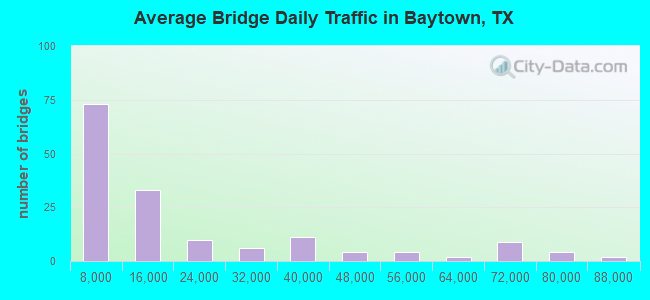
- 2,951,988Total average daily traffic
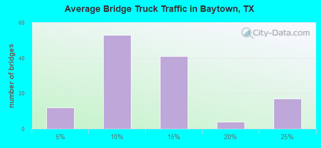
- 350,483Total average daily truck traffic
- National Bridge Inventory (NBI) Registered Bridges for Baytown
- No street view available for this location
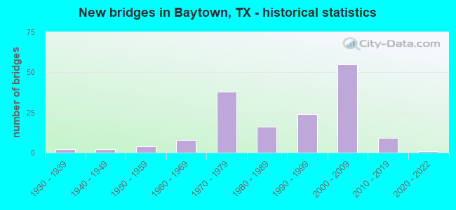
- New bridges - historical statistics
- 21930-1939
- 21940-1949
- 41950-1959
- 81960-1969
- 381970-1979
- 161980-1989
- 241990-1999
- 552000-2009
- 92010-2019
- 12020-2022
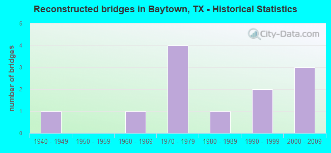
- Reconstructed bridges - Historical Statistics
- 11940-1949
- 01950-1959
- 11960-1969
- 41970-1979
- 11980-1989
- 21990-1999
- 32000-2009
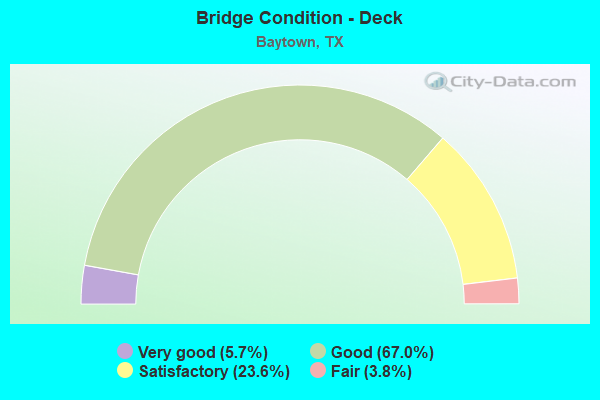
- Bridge Condition - Deck
- 5.7%Very good
- 67.0%Good
- 23.6%Satisfactory
- 3.8%Fair
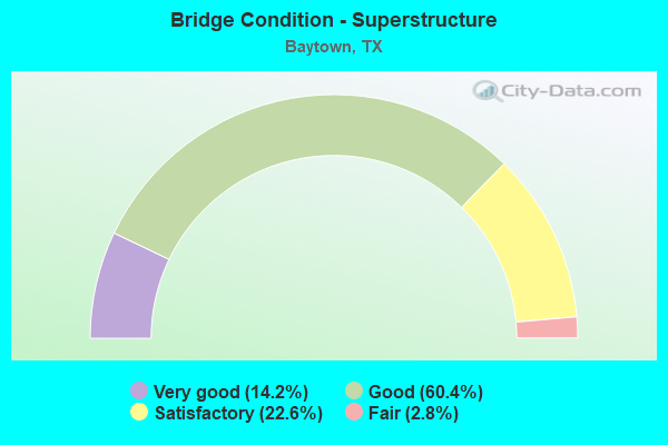
- Bridge Condition - Superstructure
- 14.2%Very good
- 60.4%Good
- 22.6%Satisfactory
- 2.8%Fair
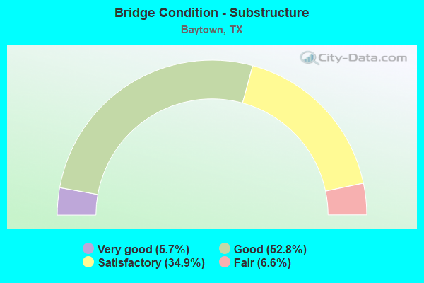
- Bridge Condition - Substructure
- 5.7%Very good
- 52.8%Good
- 34.9%Satisfactory
- 6.6%Fair

- Bridge Condition - Channel
- 8.1%Very good
- 47.7%Good
- 34.9%Satisfactory
- 9.3%Fair
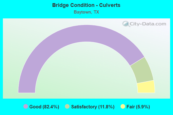
- Bridge Condition - Culverts
- 82.4%Good
- 11.8%Satisfactory
- 5.9%Fair
Find on map >> Show street view
Structure Number: 200360AA0365002, Location: 0.95 MI N OF FM 99 (Lat: 29.740192, Lng: -94.921506), Route carried "on" structure: County highway , Year Built: 1965, Status: Posted for load, Structure Length: 0.98m (3.22ft), Average Daily Traffic: 2,470 (year 2015), Average Future Daily Traffic: 4,540 (year 2035), Features Intersected: CEDAR BAYOU TRIBUTARY, Facility Carried by Structure: W BAY RD
Minimum Vertical Clearance: 30+ m (98+ ft), Kilometerpoint: 4.506, Lanes on structure: 2, Owner: County Highway Agency, Approaching Roadway Width: 6.1m (20.0ft), Material/Design: Concrete, Design/Construction: Stringer/Multi-beam, Number Of Spans In Main Unit: 1, Length of Maximum Span: 9.1m (29.9ft), Curb-To-Curb Width: 7.9m (25.9ft), Out-to-Out Width: 8.6m (28.2ft)
Condition: Deck: Good, Superstructure: Good, Substructure: Satisfactory, Channel: Satisfactory, Operating Rating: 32.7 metric tons, Method Used To Determine Operating Rating: Field evaluation and documented engineering judgment, Inventory Rating: 24.5 metric tons, Method Used To Determine Inventory Rating: Field evaluation and documented engineering judgment, Structural Evaluation: Equal to present minimum criteria, Deck Geometry: High priority of corrective action, Waterway Adequacy: Better than present minimum criteria, Approach Roadway Alignment: Equal to present desirable criteria, Bridge Posting: Required (Relationship of Operating Rating to Maximum Legal Load: 0.1 - 9.9% below), Length Of Structure Improvement: 0.98m (3.22ft), Designated Inspection Frequency: Every 24 months, Inspection Date: April 2021, Bridge Improvement Cost: $2,000, Roadway Improvement Cost: $1,000, Total Project Cost: $3,000, Deck Structure Type: Concrete Cast-file-Place, Wearing Surface/Protective System: Wearing Surface: Bituminous
Structure Number: 121020038903087, Location: 2.70 MI E OF SPUR 330, Route carried "under" structure: Business State highway 146, Year Built: 1988, Structure Length: 0. m, Average Daily Traffic: 32,680 (year 2016), Truck Traffic: 10%, Features Intersected: SH 146 BUS
Minimum Vertical Clearance: 5.18m (16.99ft), Kilometerpoint: 17.801, Material/Design: Prestressed concrete, Design/Construction: Stringer/Multi-beam, Length of Maximum Span: 26.5m (86.9ft)
Minimum Vertical Clearance: 5.18m (16.99ft), Kilometerpoint: 17.801, Material/Design: Prestressed concrete, Design/Construction: Stringer/Multi-beam, Length of Maximum Span: 26.5m (86.9ft)
Find on map >> Show street view
Structure Number: 12102003891209, Location: 0.6 MI N OF SH 225 (Lat: 29.712914, Lng: -95.003225), Route carried "under" structure: State highway 146, Year Built: 1995, Structure Length: 0. m, Truck Traffic: 8%, Features Intersected: HOUSTON SHIP CHANNEL
Minimum Vertical Clearance: 30+ m (98+ ft), Kilometerpoint: 12.830, Lanes on structure: 4, Material/Design: Steel, Design/Construction: Suspension, Length of Maximum Span: 381.0m (1,250.0ft)
Structure Number: 121020038913062, Location: 0.85 MI NE OF SH 146 BUS, Route carried "under" structure: City street , Year Built: 1971, Structure Length: 0. m, Average Daily Traffic: 3,000 (year 2010), Truck Traffic: 8%, Features Intersected: WEST MAIN STREET, Facility Carried by Structure: SH 146 NB
Minimum Vertical Clearance: 5.54m (18.18ft), Kilometerpoint: 0.000, Material/Design: Prestressed concrete, Design/Construction: Stringer/Multi-beam, Length of Maximum Span: 18.3m (60.0ft)
Minimum Vertical Clearance: 5.54m (18.18ft), Kilometerpoint: 0.000, Material/Design: Prestressed concrete, Design/Construction: Stringer/Multi-beam, Length of Maximum Span: 18.3m (60.0ft)
Structure Number: 121020038913063, Location: 1.4 MI N OF BU 146, Route carried "under" structure: City street , Year Built: 1971, Structure Length: 0. m, Average Daily Traffic: 3,000 (year 2010), Truck Traffic: 8%, Features Intersected: UPRR,MARKET & LEFEVRE ST, Facility Carried by Structure: SH 146 NB
Minimum Vertical Clearance: 7.52m (24.67ft), Kilometerpoint: 0.000, Material/Design: Prestressed concrete, Design/Construction: Stringer/Multi-beam, Length of Maximum Span: 32.0m (105.0ft)
Minimum Vertical Clearance: 7.52m (24.67ft), Kilometerpoint: 0.000, Material/Design: Prestressed concrete, Design/Construction: Stringer/Multi-beam, Length of Maximum Span: 32.0m (105.0ft)
Structure Number: 121020038913096, Location: 0.85 MI NE OF SH 146 BUS, Route carried "under" structure: City street , Year Built: 1971, Structure Length: 0. m, Average Daily Traffic: 3,000 (year 2010), Truck Traffic: 8%, Features Intersected: WEST MAIN STREET, Facility Carried by Structure: SH 146 SB
Minimum Vertical Clearance: 4.83m (15.85ft), Kilometerpoint: 0.000, Material/Design: Prestressed concrete, Design/Construction: Stringer/Multi-beam, Length of Maximum Span: 18.3m (60.0ft)
Minimum Vertical Clearance: 4.83m (15.85ft), Kilometerpoint: 0.000, Material/Design: Prestressed concrete, Design/Construction: Stringer/Multi-beam, Length of Maximum Span: 18.3m (60.0ft)
Structure Number: 121020038913097, Location: 1.4 MI N OF BU 146, Route carried "under" structure: City street , Year Built: 1971, Structure Length: 0. m, Average Daily Traffic: 3,000 (year 2010), Truck Traffic: 8%, Features Intersected: UPRR,MARKET & LEFEVRE ST, Facility Carried by Structure: SH 146 SB
Minimum Vertical Clearance: 7.75m (25.43ft), Kilometerpoint: 0.000, Material/Design: Prestressed concrete, Design/Construction: Stringer/Multi-beam, Length of Maximum Span: 32.0m (105.0ft)
Minimum Vertical Clearance: 7.75m (25.43ft), Kilometerpoint: 0.000, Material/Design: Prestressed concrete, Design/Construction: Stringer/Multi-beam, Length of Maximum Span: 32.0m (105.0ft)
Structure Number: 121020038913106, Location: 0.30 MI NE OF SH 146 BUS, Route carried "under" structure: City street , Year Built: 1996, Structure Length: 0. m, Average Daily Traffic: 4,640 (year 2010), Features Intersected: MISSOURI ST, Facility Carried by Structure: SH 146
Minimum Vertical Clearance: 5.26m (17.26ft), Kilometerpoint: 0.002, Material/Design: Prestressed concrete, Design/Construction: Stringer/Multi-beam, Length of Maximum Span: 30.5m (100.1ft)
Minimum Vertical Clearance: 5.26m (17.26ft), Kilometerpoint: 0.002, Material/Design: Prestressed concrete, Design/Construction: Stringer/Multi-beam, Length of Maximum Span: 30.5m (100.1ft)
Structure Number: 121020038913109, Location: 0.50 MI SW OF SPUR 330, Route carried "under" structure: City street , Year Built: 1996, Structure Length: 0. m, Average Daily Traffic: 3,000 (year 2010), Truck Traffic: 8%, Features Intersected: W TEXAS AVE, Facility Carried by Structure: SH 146
Minimum Vertical Clearance: 5.39m (17.68ft), Kilometerpoint: 0.000, Material/Design: Prestressed concrete, Design/Construction: Stringer/Multi-beam, Length of Maximum Span: 24.4m (80.1ft)
Minimum Vertical Clearance: 5.39m (17.68ft), Kilometerpoint: 0.000, Material/Design: Prestressed concrete, Design/Construction: Stringer/Multi-beam, Length of Maximum Span: 24.4m (80.1ft)
Structure Number: 12102003891311, Location: AT BU 146 & SH 146 INTER., Route carried "under" structure: State highway 146, Year Built: 1996, Structure Length: 0. m, Average Daily Traffic: 46,390 (year 2013), Truck Traffic: 8%, Features Intersected: SH 146 ML
Minimum Vertical Clearance: 7.47m (24.51ft), Kilometerpoint: 26.281, Material/Design: Steel continuous, Design/Construction: Stringer/Multi-beam, Length of Maximum Span: 67.1m (220.1ft)
Minimum Vertical Clearance: 7.47m (24.51ft), Kilometerpoint: 26.281, Material/Design: Steel continuous, Design/Construction: Stringer/Multi-beam, Length of Maximum Span: 67.1m (220.1ft)
Structure Number: 121020038913111, Location: 0.40 MI E OF SPUR 330, Route carried "under" structure: City street , Year Built: 1996, Structure Length: 0. m, Average Daily Traffic: 5,000 (year 2010), Truck Traffic: 8%, Features Intersected: GOOSE CREEK, GARTH RD, Facility Carried by Structure: SH 146
Minimum Vertical Clearance: 5.51m (18.08ft), Kilometerpoint: 0.000, Material/Design: Prestressed concrete, Design/Construction: Stringer/Multi-beam, Length of Maximum Span: 34.1m (111.9ft)
Minimum Vertical Clearance: 5.51m (18.08ft), Kilometerpoint: 0.000, Material/Design: Prestressed concrete, Design/Construction: Stringer/Multi-beam, Length of Maximum Span: 34.1m (111.9ft)
Find on map >> Show street view
Structure Number: 121020038913112, Location: 1.45 MI E OF SPUR 330 (Lat: 29.750589, Lng: -94.963397), Route carried "under" structure: City street , Year Built: 1996, Structure Length: 0. m, Average Daily Traffic: 5,000 (year 2010), Truck Traffic: 8%, Features Intersected: NORTH MAIN ST, Facility Carried by Structure: SH 146
Minimum Vertical Clearance: 5.08m (16.67ft), Kilometerpoint: 0.000, Lanes on structure: 6, Lanes under structure: 8, Material/Design: Prestressed concrete, Design/Construction: Stringer/Multi-beam, Length of Maximum Span: 35.1m (115.2ft)
Structure Number: 121020038913118, Location: AT JCT SH146 AND SPUR330, Route carried "under" structure: State highway 146, Year Built: 2002, Structure Length: 0. m, Average Daily Traffic: 42,300 (year 2010), Features Intersected: SH 146, SP330, DECKER DR
Minimum Vertical Clearance: 9.65m (31.66ft), Kilometerpoint: 22.180, Material/Design: Prestressed concrete, Design/Construction: Stringer/Multi-beam, Length of Maximum Span: 36.6m (120.1ft)
Minimum Vertical Clearance: 9.65m (31.66ft), Kilometerpoint: 22.180, Material/Design: Prestressed concrete, Design/Construction: Stringer/Multi-beam, Length of Maximum Span: 36.6m (120.1ft)
Structure Number: 121020038913268, Location: AT INT SH 146 & SPUR 330, Route carried "under" structure: Spur State highway 330, Year Built: 1982, Structure Length: 0. m, Average Daily Traffic: 10,950 (year 2013), Truck Traffic: 11%, Features Intersected: SPUR 330, Facility Carried by Structure: SH 146 SB
Minimum Vertical Clearance: 6.04m (19.82ft), Kilometerpoint: 8.420, Material/Design: Prestressed concrete, Design/Construction: Stringer/Multi-beam, Length of Maximum Span: 25.6m (84.0ft)
Minimum Vertical Clearance: 6.04m (19.82ft), Kilometerpoint: 8.420, Material/Design: Prestressed concrete, Design/Construction: Stringer/Multi-beam, Length of Maximum Span: 25.6m (84.0ft)
Structure Number: 121020038913269, Location: AT INT SH 146 & SPUR 330, Route carried "under" structure: Spur State highway 330, Year Built: 1982, Structure Length: 0. m, Average Daily Traffic: 43,180 (year 2013), Truck Traffic: 11%, Features Intersected: SPUR 330, Facility Carried by Structure: SH 146 NB
Minimum Vertical Clearance: 5.33m (17.49ft), Kilometerpoint: 8.385, Material/Design: Prestressed concrete, Design/Construction: Stringer/Multi-beam, Length of Maximum Span: 25.6m (84.0ft)
Minimum Vertical Clearance: 5.33m (17.49ft), Kilometerpoint: 8.385, Material/Design: Prestressed concrete, Design/Construction: Stringer/Multi-beam, Length of Maximum Span: 25.6m (84.0ft)
Find on map >> Show street view
Structure Number: 121020038913343, Location: AT INT SH 146 & SPUR 330 (Lat: 29.752806, Lng: -94.990625), Route carried "under" structure: Spur State highway 330, Year Built: 2010, Structure Length: 0. m, Average Daily Traffic: 26,030 (year 2013), Truck Traffic: 9%, Features Intersected: SH 146 SB FR
Minimum Vertical Clearance: 6.22m (20.41ft), Kilometerpoint: 0.002, Lanes on structure: 1, Lanes under structure: 7, Material/Design: Steel continuous, Design/Construction: Stringer/Multi-beam, Length of Maximum Span: 67.1m (220.1ft)
Structure Number: 121020038913344, Location: AT INT SH 146 & SPUR 330, Route carried "under" structure: State highway 146, Year Built: 2010, Structure Length: 0. m, Average Daily Traffic: 25,520 (year 2011), Truck Traffic: 5%, Features Intersected: SH 146
Minimum Vertical Clearance: 5.61m (18.41ft), Kilometerpoint: 0.000, Material/Design: Prestressed concrete, Design/Construction: Stringer/Multi-beam, Length of Maximum Span: 44.2m (145.0ft)
Minimum Vertical Clearance: 5.61m (18.41ft), Kilometerpoint: 0.000, Material/Design: Prestressed concrete, Design/Construction: Stringer/Multi-beam, Length of Maximum Span: 44.2m (145.0ft)
Find on map >> Show street view
Structure Number: 121020038913345, Location: AT INT SH 146 & SPUR 330 (Lat: 29.748347, Lng: -94.987256), Route carried "under" structure: Spur State highway 330, Year Built: 2010, Structure Length: 0. m, Average Daily Traffic: 26,030 (year 2013), Truck Traffic: 9%, Features Intersected: SPUR 330 EB
Minimum Vertical Clearance: 5.23m (17.16ft), Kilometerpoint: 0.002, Lanes on structure: 1, Lanes under structure: 2, Material/Design: Prestressed concrete, Design/Construction: Stringer/Multi-beam, Length of Maximum Span: 36.6m (120.1ft)
Find on map >> Show street view
Structure Number: 121020038913358, Location: AT INT OF SH 146 & S 330 (Lat: 29.749853, Lng: -94.981769), Route carried "under" structure: ServiceState highway 146, Year Built: 2010, Structure Length: 0. m, Average Daily Traffic: 7,190 (year 2013), Truck Traffic: 8%, Features Intersected: SH 146 SB FR
Minimum Vertical Clearance: 16.87m (55.35ft), Kilometerpoint: 0.002, Lanes on structure: 1, Lanes under structure: 3, Material/Design: Prestressed concrete, Design/Construction: Stringer/Multi-beam, Length of Maximum Span: 35.1m (115.2ft)
Find on map >> Show street view
Structure Number: 121020050801197, Location: 0.50 MI E OF CROSBY/LYNCH (Lat: 29.791239, Lng: -95.049872), Route carried "under" structure: Interstate 10, Year Built: 1971, Structure Length: 0. m, Average Daily Traffic: 78,960 (year 2013), Truck Traffic: 20%, Features Intersected: IH 10, Facility Carried by Structure: SPUR 330 WB
Minimum Vertical Clearance: 5.72m (18.77ft), Kilometerpoint: 75.736, Lanes on structure: 2, Lanes under structure: 7, Material/Design: Prestressed concrete, Design/Construction: Stringer/Multi-beam, Length of Maximum Span: 25.3m (83.0ft)
Find on map >> Show street view
Structure Number: 121020050801224, Location: 0.45 MI E OF CROSBY/LYNCH (Lat: 29.790006, Lng: -95.050447), Route carried "under" structure: Spur State highway 330, Year Built: 1971, Structure Length: 0. m, Average Daily Traffic: 13,900 (year 2011), Truck Traffic: 10%, Features Intersected: SPUR 330 EB, Facility Carried by Structure: IH 10 EB ON RP
Minimum Vertical Clearance: 5.41m (17.75ft), Kilometerpoint: 0.380, Lanes on structure: 1, Lanes under structure: 2, Material/Design: Prestressed concrete, Design/Construction: Stringer/Multi-beam, Length of Maximum Span: 27.7m (90.9ft)
Structure Number: 121020050801331, Location: 7.75 MI E OF SAN JAC RIV, Route carried "under" structure: City street , Year Built: 2001, Structure Length: 0. m, Average Daily Traffic: 500 (year 2010), Truck Traffic: 10%, Features Intersected: SJOLANDER RD, Facility Carried by Structure: IH 10
Minimum Vertical Clearance: 5.31m (17.42ft), Kilometerpoint: 86.782, Material/Design: Prestressed concrete, Design/Construction: Stringer/Multi-beam, Length of Maximum Span: 36.0m (118.1ft)
Minimum Vertical Clearance: 5.31m (17.42ft), Kilometerpoint: 86.782, Material/Design: Prestressed concrete, Design/Construction: Stringer/Multi-beam, Length of Maximum Span: 36.0m (118.1ft)
Find on map >> Show street view
Structure Number: 121020050801333, Location: 6.0 MI E OF SAN JAC RIVER (Lat: 29.808119, Lng: -94.964806), Route carried "under" structure: City street , Year Built: 2001, Structure Length: 0. m, Average Daily Traffic: 500 (year 2010), Truck Traffic: 10%, Features Intersected: NORTH MAIN ST, Facility Carried by Structure: IH 10
Minimum Vertical Clearance: 5.33m (17.49ft), Kilometerpoint: 84.143, Lanes on structure: 6, Lanes under structure: 4, Material/Design: Prestressed concrete, Design/Construction: Stringer/Multi-beam, Length of Maximum Span: 35.7m (117.1ft)
Structure Number: 121020050801334, Location: 5.0 MI E OF SAN JAC RIVER, Route carried "under" structure: City street , Year Built: 2001, Structure Length: 0. m, Average Daily Traffic: 500 (year 2010), Truck Traffic: 10%, Features Intersected: GARTH RD, Facility Carried by Structure: IH 10
Minimum Vertical Clearance: 5.79m (19.00ft), Kilometerpoint: 82.513, Material/Design: Prestressed concrete, Design/Construction: Stringer/Multi-beam, Length of Maximum Span: 29.6m (97.1ft)
Minimum Vertical Clearance: 5.79m (19.00ft), Kilometerpoint: 82.513, Material/Design: Prestressed concrete, Design/Construction: Stringer/Multi-beam, Length of Maximum Span: 29.6m (97.1ft)
Structure Number: 121020050801335, Location: 4.0 MI E OF SAN JAC RIVER, Route carried "under" structure: City street , Year Built: 2001, Structure Length: 0. m, Average Daily Traffic: 500 (year 2010), Truck Traffic: 10%, Features Intersected: JOHN MARTIN RD, Facility Carried by Structure: IH 10
Minimum Vertical Clearance: 5.87m (19.26ft), Kilometerpoint: 80.956, Material/Design: Prestressed concrete, Design/Construction: Stringer/Multi-beam, Length of Maximum Span: 29.6m (97.1ft)
Minimum Vertical Clearance: 5.87m (19.26ft), Kilometerpoint: 80.956, Material/Design: Prestressed concrete, Design/Construction: Stringer/Multi-beam, Length of Maximum Span: 29.6m (97.1ft)
Find on map >> Show street view
Structure Number: 121020050801336, Location: 2.1 MI W OF GARTH RD (Lat: 29.799806, Lng: -95.017494), Route carried "under" structure: City street , Year Built: 2001, Structure Length: 0. m, Average Daily Traffic: 2,500 (year 2011), Truck Traffic: 10%, Features Intersected: UP RR & WADE RD, Facility Carried by Structure: IH 10
Minimum Vertical Clearance: 7.95m (26.08ft), Kilometerpoint: 79.051, Lanes on structure: 8, Lanes under structure: 4, Material/Design: Prestressed concrete, Design/Construction: Stringer/Multi-beam, Length of Maximum Span: 31.1m (102.0ft)
Structure Number: 121020050801337, Location: 1.2 MI E OF SPUR 330, Route carried "under" structure: City street , Year Built: 2001, Structure Length: 0. m, Average Daily Traffic: 3,500 (year 2011), Truck Traffic: 10%, Features Intersected: THOMPSON RD, Facility Carried by Structure: IH 10
Minimum Vertical Clearance: 5.82m (19.09ft), Kilometerpoint: 77.566, Material/Design: Prestressed concrete, Design/Construction: Stringer/Multi-beam, Length of Maximum Span: 32.0m (105.0ft)
Minimum Vertical Clearance: 5.82m (19.09ft), Kilometerpoint: 77.566, Material/Design: Prestressed concrete, Design/Construction: Stringer/Multi-beam, Length of Maximum Span: 32.0m (105.0ft)
Find on map >> Show street view
Structure Number: 121020050807303, Location: 1.10 MI SE OF IH 10 (Lat: 29.783003, Lng: -95.031569), Route carried "under" structure: City street , Year Built: 2003, Structure Length: 0. m, Average Daily Traffic: 500 (year 2011), Truck Traffic: 8%, Features Intersected: BAYWAY DR, Facility Carried by Structure: SPUR 330 WB
Minimum Vertical Clearance: 5.23m (17.16ft), Kilometerpoint: 1.770, Lanes on structure: 3, Lanes under structure: 8, Material/Design: Prestressed concrete, Design/Construction: Stringer/Multi-beam, Length of Maximum Span: 38.7m (127.0ft)
Find on map >> Show street view
Structure Number: 121020050807304, Location: 1.10 MI SE OF IH 10 (Lat: 29.783056, Lng: -95.032528), Route carried "under" structure: City street , Year Built: 2003, Structure Length: 0. m, Average Daily Traffic: 500 (year 2011), Truck Traffic: 8%, Features Intersected: BAYWAY DR, Facility Carried by Structure: SPUR 330 EB
Minimum Vertical Clearance: 5.28m (17.32ft), Kilometerpoint: 1.770, Lanes on structure: 3, Lanes under structure: 8, Material/Design: Prestressed concrete, Design/Construction: Stringer/Multi-beam, Length of Maximum Span: 38.7m (127.0ft)
Structure Number: 121020050807305, Location: 2.5 MI SE OF IH 10, Route carried "under" structure: City street , Year Built: 2003, Structure Length: 0. m, Average Daily Traffic: 3,500 (year 2011), Truck Traffic: 8%, Features Intersected: MPRR, WADE RD, BAKER RD, Facility Carried by Structure: SPUR 330 WB
Minimum Vertical Clearance: 7.34m (24.08ft), Kilometerpoint: 4.023, Material/Design: Prestressed concrete, Design/Construction: Stringer/Multi-beam, Length of Maximum Span: 36.6m (120.1ft)
Minimum Vertical Clearance: 7.34m (24.08ft), Kilometerpoint: 4.023, Material/Design: Prestressed concrete, Design/Construction: Stringer/Multi-beam, Length of Maximum Span: 36.6m (120.1ft)
Structure Number: 121020050807306, Location: 2.50 MI SE OF IH 10, Route carried "under" structure: City street , Year Built: 2003, Structure Length: 0. m, Average Daily Traffic: 3,500 (year 2011), Truck Traffic: 8%, Features Intersected: MPRR, WADE RD, BAKER RD, Facility Carried by Structure: SPUR 330 EB
Minimum Vertical Clearance: 7.24m (23.75ft), Kilometerpoint: 4.023, Material/Design: Prestressed concrete, Design/Construction: Stringer/Multi-beam, Length of Maximum Span: 36.6m (120.1ft)
Minimum Vertical Clearance: 7.24m (23.75ft), Kilometerpoint: 4.023, Material/Design: Prestressed concrete, Design/Construction: Stringer/Multi-beam, Length of Maximum Span: 36.6m (120.1ft)
Structure Number: 121020050807307, Location: 0.85 MI NW OF SH 146, Route carried "under" structure: City street , Year Built: 2002, Structure Length: 0. m, Average Daily Traffic: 28,860 (year 2010), Truck Traffic: 10%, Features Intersected: ROLLINGBROOK DRIVE, Facility Carried by Structure: SPUR 330 EB
Minimum Vertical Clearance: 5.13m (16.83ft), Kilometerpoint: 76.347, Material/Design: Prestressed concrete, Design/Construction: Stringer/Multi-beam, Length of Maximum Span: 32.0m (105.0ft)
Minimum Vertical Clearance: 5.13m (16.83ft), Kilometerpoint: 76.347, Material/Design: Prestressed concrete, Design/Construction: Stringer/Multi-beam, Length of Maximum Span: 32.0m (105.0ft)
Structure Number: 121020050807308, Location: 0.85 MI NW OF SH 146, Route carried "under" structure: City street , Year Built: 2002, Structure Length: 0. m, Average Daily Traffic: 28,860 (year 2010), Truck Traffic: 10%, Features Intersected: ROLLINGBROOK DRIVE, Facility Carried by Structure: SPUR 330 WB
Minimum Vertical Clearance: 5.56m (18.24ft), Kilometerpoint: 6.960, Material/Design: Prestressed concrete, Design/Construction: Stringer/Multi-beam, Length of Maximum Span: 32.0m (105.0ft)
Minimum Vertical Clearance: 5.56m (18.24ft), Kilometerpoint: 6.960, Material/Design: Prestressed concrete, Design/Construction: Stringer/Multi-beam, Length of Maximum Span: 32.0m (105.0ft)
Structure Number: 121020050807343, Location: 0.45 MI NW OF SH 146, Route carried "under" structure: Spur State highway 330, Year Built: 2002, Structure Length: 0. m, Average Daily Traffic: 11,000 (year 2010), Truck Traffic: 11%, Features Intersected: SPUR 330 WB
Minimum Vertical Clearance: 5.03m (16.50ft), Kilometerpoint: 77.907, Material/Design: Prestressed concrete, Design/Construction: Stringer/Multi-beam, Length of Maximum Span: 34.7m (113.8ft)
Minimum Vertical Clearance: 5.03m (16.50ft), Kilometerpoint: 77.907, Material/Design: Prestressed concrete, Design/Construction: Stringer/Multi-beam, Length of Maximum Span: 34.7m (113.8ft)
Find on map >> Show street view
Structure Number: 200360050802328, Location: IH 10 @ SH 146 (Lat: 29.821767, Lng: -94.898489), Route carried "under" structure: Interstate 146, Year Built: 2000, Structure Length: 0. m, Average Daily Traffic: 56,410 (year 2016), Truck Traffic: 24%, Features Intersected: SH 146, Facility Carried by Structure: IH 10
Minimum Vertical Clearance: 5.23m (17.16ft), Kilometerpoint: 1.033, Lanes on structure: 6, Lanes under structure: 8, Material/Design: Prestressed concrete, Design/Construction: Stringer/Multi-beam, Length of Maximum Span: 37.8m (124.0ft)
Find on map >> Show street view
Structure Number: 200360351010031, Location: 2.8 MI S OF IH 10 (Lat: 29.786214, Lng: -94.871753), Route carried "under" structure: State highway 565, Year Built: 2007, Structure Length: 0. m, Average Daily Traffic: 7,730 (year 2013), Truck Traffic: 3%, Features Intersected: FM 565, Facility Carried by Structure: SH 99 SB
Minimum Vertical Clearance: 5.54m (18.18ft), Kilometerpoint: 1.146, Lanes on structure: 2, Lanes under structure: 7, Material/Design: Prestressed concrete, Design/Construction: Stringer/Multi-beam, Length of Maximum Span: 36.6m (120.1ft)
Find on map >> Show street view
Structure Number: 200360351010032, Location: 2.8 MI S OF IH 10 (Lat: 29.784944, Lng: -94.871881), Route carried "under" structure: State highway 565, Year Built: 2007, Structure Length: 0. m, Average Daily Traffic: 7,730 (year 2013), Truck Traffic: 3%, Features Intersected: FM 565, Facility Carried by Structure: SH 99 NB
Minimum Vertical Clearance: 5.11m (16.77ft), Kilometerpoint: 1.146, Lanes on structure: 2, Lanes under structure: 7, Material/Design: Prestressed concrete, Design/Construction: Stringer/Multi-beam, Length of Maximum Span: 36.6m (120.1ft)