Bridge Statistics for Bellingham, Washington (WA)
Condition, Traffic, Stress, Structural Evaluation, Project Costs
- National Bridge Inventory (NBI) Statistics
- 79Number of bridges
- 961ft / 293mTotal length
- $207,119,000Total costs
- 1,527,865Total average daily traffic
- 92,028Total average daily truck traffic
- National Bridge Inventory (NBI) Registered Bridges for Bellingham
- No street view available for this location
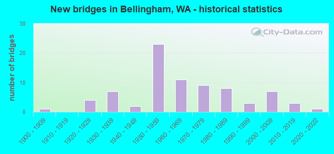
- New bridges - historical statistics
- 11900-1909
- 41920-1929
- 71930-1939
- 21940-1949
- 231950-1959
- 111960-1969
- 91970-1979
- 81980-1989
- 31990-1999
- 72000-2009
- 32010-2019
- 12020-2022
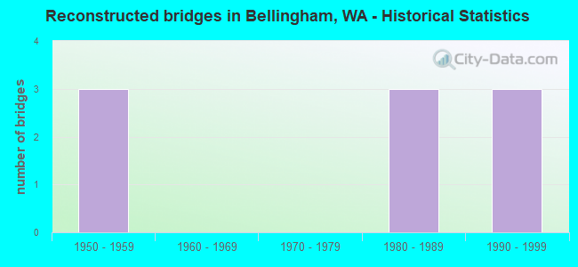
- Reconstructed bridges - Historical Statistics
- 31950-1959
- 01960-1969
- 01970-1979
- 31980-1989
- 31990-1999
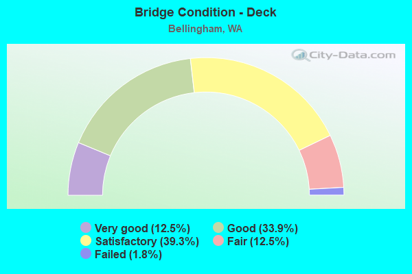
- Bridge Condition - Deck
- 12.5%Very good
- 33.9%Good
- 39.3%Satisfactory
- 12.5%Fair
- 1.8%Failed
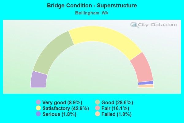
- Bridge Condition - Superstructure
- 8.9%Very good
- 28.6%Good
- 42.9%Satisfactory
- 16.1%Fair
- 1.8%Serious
- 1.8%Failed
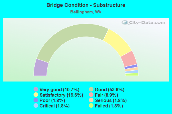
- Bridge Condition - Substructure
- 10.7%Very good
- 53.6%Good
- 19.6%Satisfactory
- 8.9%Fair
- 1.8%Poor
- 1.8%Serious
- 1.8%Critical
- 1.8%Failed
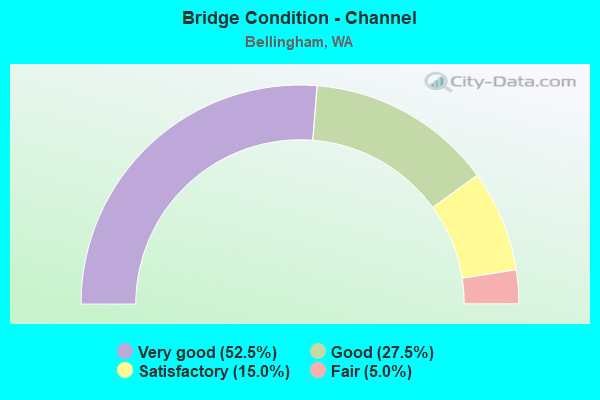
- Bridge Condition - Channel
- 52.5%Very good
- 27.5%Good
- 15.0%Satisfactory
- 5.0%Fair
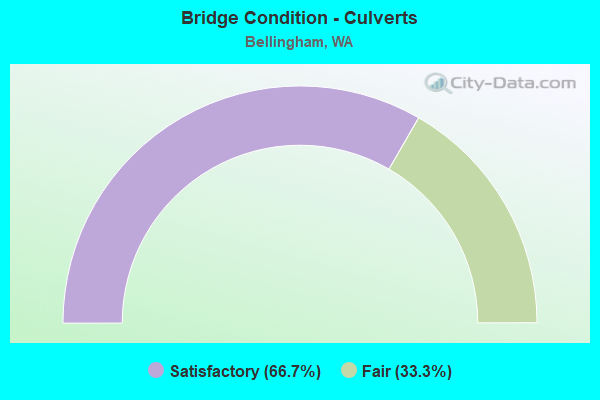
- Bridge Condition - Culverts
- 66.7%Satisfactory
- 33.3%Fair
Find on map >> Show street view
Structure Number: 85432, Location: 1.5 NW. CITY HALL (Lat: 48.772806, Lng: -122.494444), Route carried "on" structure: City street 90306, Year Built: 1971, Status: Open, Structure Length: 10.03m (32.91ft), Average Daily Traffic: 10,700 (year 2021), Truck Traffic: 5%, Average Future Daily Traffic: 15,000 (year 2043), Design Load: H 20, Features Intersected: SQUALLICUM WY,CRK,CMSTP&, Facility Carried by Structure: NORTHWEST AVENUE
Minimum Vertical Clearance: 30+ m (98+ ft), Kilometerpoint: 2.768, Lanes on structure: 2, Lanes under structure: 2, Base Highway Network: Yes, Owner: City or Municipal Highway Agency, Approaching Roadway Width: 13.4m (44.0ft), Material/Design: Concrete continuous, Design/Construction: Slab, Number Of Spans In Main Unit: 5, Length of Maximum Span: 24.4m (80.1ft), Curb or Sidewalk Widths: Left: 1.5m (4.9ft), Right: 1.5m (4.9ft), Curb-To-Curb Width: 13.4m (44.0ft), Out-to-Out Width: 17.0m (55.8ft)
Condition: Deck: Good, Superstructure: Satisfactory, Substructure: Good, Operating Rating: 66.7 metric tons, Method Used To Determine Operating Rating: Load Factor (LF) rating reported by rating factor (RF) method using MS18 loading, Inventory Rating: 39.9 metric tons, Method Used To Determine Inventory Rating: Load Factor (LF) rating reported by rating factor (RF) method using MS18 loading, Structural Evaluation: Equal to present minimum criteria, Deck Geometry: Equal to present minimum criteria, Underclear: Superior to present desirable criteria, Approach Roadway Alignment: Equal to present desirable criteria, Length Of Structure Improvement: 10.03m (32.91ft), Designated Inspection Frequency: Every 24 months, Inspection Date: April 2021, Bridge Improvement Cost: $3,027,000, Roadway Improvement Cost: $605,000, Total Project Cost: $6,054,000 ( Estimate for 2014), Deck Structure Type: Concrete Cast-file-Place, Wearing Surface/Protective System: Wearing Surface: Latex Concrete, Deck Protection: Internally Sealed
Find on map >> Show street view
Structure Number: 85433, Location: BOX CUL 1 SQUALL WY (Lat: 48.765194, Lng: -122.501583), Route carried "on" structure: City street 86801, Year Built: 1970, Status: Open, Structure Length: 0.85m (2.79ft), Average Daily Traffic: 4,200 (year 2021), Truck Traffic: 5%, Average Future Daily Traffic: 6,100 (year 2043), Design Load: HS 20, Features Intersected: SQUALLICUM CREEK, Facility Carried by Structure: SQUALLICUM WAY
Minimum Vertical Clearance: 30+ m (98+ ft), Kilometerpoint: 0.001, Lanes on structure: 2, Owner: City or Municipal Highway Agency, Approaching Roadway Width: 12.8m (42.0ft), Skew: 4 degrees, Material/Design: Concrete continuous, Design/Construction: Culvert, Number Of Spans In Main Unit: 3, Length of Maximum Span: 2.7m (8.9ft)
Condition: Channel: Satisfactory, Culverts: Fair, Operating Rating: 67.7 metric tons, Method Used To Determine Operating Rating: Load Factor (LF) rating reported by rating factor (RF) method using MS18 loading, Inventory Rating: 40.5 metric tons, Method Used To Determine Inventory Rating: Load Factor (LF) rating reported by rating factor (RF) method using MS18 loading, Structural Evaluation: Somewhat better than minimum adequacy, Waterway Adequacy: Equal to present desirable criteria, Approach Roadway Alignment: Equal to present desirable criteria, Length Of Structure Improvement: 0.85m (2.79ft), Designated Inspection Frequency: Every 24 months, Inspection Date: May 2021, Bridge Improvement Cost: $246,000, Roadway Improvement Cost: $49,000, Total Project Cost: $493,000 ( Estimate for 2014)
Find on map >> Show street view
Structure Number: 85434, Location: BOX CUL 2 SQUALL WY (Lat: 48.765778, Lng: -122.500194), Route carried "on" structure: City street 86801, Year Built: 1970, Status: Open, Structure Length: 0.82m (2.69ft), Average Daily Traffic: 4,200 (year 2021), Truck Traffic: 5%, Average Future Daily Traffic: 6,100 (year 2043), Design Load: HS 20, Features Intersected: SQUALLICUM CREEK, Facility Carried by Structure: SQUALLICUM WAY
Minimum Vertical Clearance: 30+ m (98+ ft), Kilometerpoint: 0.001, Lanes on structure: 2, Owner: City or Municipal Highway Agency, Approaching Roadway Width: 13.4m (44.0ft), Skew: 4 degrees, Material/Design: Concrete continuous, Design/Construction: Culvert, Number Of Spans In Main Unit: 3, Length of Maximum Span: 2.4m (7.9ft)
Condition: Channel: Satisfactory, Culverts: Satisfactory, Operating Rating: 67.7 metric tons, Method Used To Determine Operating Rating: Load Factor (LF) rating reported by rating factor (RF) method using MS18 loading, Inventory Rating: 40.5 metric tons, Method Used To Determine Inventory Rating: Load Factor (LF) rating reported by rating factor (RF) method using MS18 loading, Structural Evaluation: Equal to present minimum criteria, Waterway Adequacy: Equal to present minimum criteria, Approach Roadway Alignment: Equal to present desirable criteria, Length Of Structure Improvement: 0.82m (2.69ft), Designated Inspection Frequency: Every 24 months, Inspection Date: May 2021, Bridge Improvement Cost: $248,000, Roadway Improvement Cost: $50,000, Total Project Cost: $497,000 ( Estimate for 2014)
Find on map >> Show street view
Structure Number: 85435, Location: BOX CUL 3 SQUALL WY (Lat: 48.772556, Lng: -122.495278), Route carried "on" structure: City street 86801, Year Built: 1970, Status: Open, Structure Length: 12.83m (42.09ft), Average Daily Traffic: 4,200 (year 2021), Truck Traffic: 5%, Average Future Daily Traffic: 6,100 (year 2043), Design Load: HS 20, Features Intersected: SQUALLICUM CREEK, Facility Carried by Structure: SQUALLICUM WAY
Minimum Vertical Clearance: 8.53m (27.99ft), Kilometerpoint: 0.001, Lanes on structure: 2, Owner: City or Municipal Highway Agency, Approaching Roadway Width: 13.4m (44.0ft), Skew: 9 degrees, Material/Design: Concrete continuous, Design/Construction: Culvert, Number Of Spans In Main Unit: 3, Length of Maximum Span: 1.8m (5.9ft)
Condition: Channel: Good, Culverts: Satisfactory, Operating Rating: 67.7 metric tons, Method Used To Determine Operating Rating: Load Factor (LF) rating reported by rating factor (RF) method using MS18 loading, Inventory Rating: 40.5 metric tons, Method Used To Determine Inventory Rating: Load Factor (LF) rating reported by rating factor (RF) method using MS18 loading, Structural Evaluation: Equal to present minimum criteria, Waterway Adequacy: Equal to present desirable criteria, Approach Roadway Alignment: Equal to present desirable criteria, Length Of Structure Improvement: 12.83m (42.09ft), Designated Inspection Frequency: Every 24 months, Inspection Date: May 2021, Bridge Improvement Cost: $3,873,000, Roadway Improvement Cost: $775,000, Total Project Cost: $7,746,000 ( Estimate for 2014)
Find on map >> Show street view
Structure Number: 85507, Location: 0.06 N JCT MEADOR AVE (Lat: 48.754222, Lng: -122.464939), Route carried "on" structure: City street 30303, Year Built: 1936, Year Reconstructed: 1962, Status: Open, Structure Length: 1.71m (5.61ft), Average Daily Traffic: 7,000 (year 2021), Truck Traffic: 5%, Average Future Daily Traffic: 8,400 (year 2043), Design Load: H 15, Features Intersected: WHATCOM CREEK, Facility Carried by Structure: JAMES STREET
Minimum Vertical Clearance: 30+ m (98+ ft), Kilometerpoint: 0.001, Lanes on structure: 2, Owner: City or Municipal Highway Agency, Approaching Roadway Width: 11.6m (38.1ft), Material/Design: Concrete, Design/Construction: Channel Beam, Number Of Spans In Main Unit: 3, Length of Maximum Span: 5.8m (19.0ft), Curb or Sidewalk Widths: Left: 0.0m, Right: 1.1m (3.6ft), Curb-To-Curb Width: 7.3m (24.0ft), Out-to-Out Width: 9.1m (29.9ft)
Condition: Deck: Fair, Superstructure: Fair, Substructure: Serious, Channel: Good, Operating Rating: 37.9 metric tons, Method Used To Determine Operating Rating: Load Factor (LF) rating reported by rating factor (RF) method using MS18 loading, Inventory Rating: 22.7 metric tons, Method Used To Determine Inventory Rating: Load Factor (LF) rating reported by rating factor (RF) method using MS18 loading, Structural Evaluation: High priority of corrective action, Deck Geometry: High priority of replacement, Waterway Adequacy: Equal to present minimum criteria, Approach Roadway Alignment: Equal to present minimum criteria, Length Of Structure Improvement: 2.01m (6.59ft), Designated Inspection Frequency: Every 24 months, Inspection Date: May 2021, Bridge Improvement Cost: $1,003,000, Roadway Improvement Cost: $201,000, Total Project Cost: $2,006,000 ( Estimate for 2014), Deck Structure Type: Other, Wearing Surface/Protective System: Wearing Surface: Bituminous
Find on map >> Show street view
Structure Number: 85522, Location: .3 W OF CITY HALL (Lat: 48.753028, Lng: -122.484000), Route carried "on" structure: City street 86601, Year Built: 1922, Status: Posted for load, Structure Length: 0.98m (3.22ft), Average Daily Traffic: 8,700 (year 2021), Truck Traffic: 5%, Average Future Daily Traffic: 12,000 (year 2043), Design Load: H 15, Features Intersected: WHATCOM CREEK, Facility Carried by Structure: HOLLY STREET
Minimum Vertical Clearance: 30+ m (98+ ft), Kilometerpoint: 1.287, Lanes on structure: 2, Base Highway Network: Yes, Owner: City or Municipal Highway Agency, Approaching Roadway Width: 15.2m (49.9ft), Material/Design: Concrete, Design/Construction: Tee Beam, Number Of Spans In Main Unit: 1, Length of Maximum Span: 9.1m (29.9ft), Curb or Sidewalk Widths: Left: 4.3m (14.1ft), Right: 4.4m (14.4ft), Curb-To-Curb Width: 15.3m (50.2ft), Out-to-Out Width: 24.6m (80.7ft)
Condition: Deck: Satisfactory, Superstructure: Fair, Substructure: Fair, Channel: Satisfactory, Operating Rating: 24.5 metric tons, Method Used To Determine Operating Rating: Load Factor (LF), Inventory Rating: 14.5 metric tons, Method Used To Determine Inventory Rating: Load Factor (LF), Structural Evaluation: High priority of replacement, Deck Geometry: Superior to present desirable criteria, Waterway Adequacy: Equal to present desirable criteria, Approach Roadway Alignment: Equal to present desirable criteria, Bridge Posting: Required (Relationship of Operating Rating to Maximum Legal Load: 10.0 - 19.9% below), Length Of Structure Improvement: 1.28m (4.20ft), Designated Inspection Frequency: Every 24 months, Underwater Inspection Frequency: Every 60 months, Inspection Date: April 2021, Underwater Inspection Date: June 2017, Bridge Improvement Cost: $638,000, Roadway Improvement Cost: $128,000, Total Project Cost: $1,277,000 ( Estimate for 2014), Deck Structure Type: Concrete Cast-file-Place, Wearing Surface/Protective System: Wearing Surface: Bituminous
Find on map >> Show street view
Structure Number: 85526, Location: AT JCT W CHESTNUT/BAY ST (Lat: 48.750481, Lng: -122.482175), Route carried "on" structure: City street 86403, Year Built: 1930, Year Reconstructed: 1988, Status: Open, Structure Length: 9.14m (29.99ft), Average Daily Traffic: 6,000 (year 2021), Truck Traffic: 5%, Average Future Daily Traffic: 9,800 (year 2043), Design Load: H 20, Features Intersected: BURLINGTON NORTHERN, Facility Carried by Structure: CHESTNUT ST-BAY ST
Minimum Vertical Clearance: 30+ m (98+ ft), Kilometerpoint: 1.110, Lanes on structure: 2, Base Highway Network: Yes, Owner: City or Municipal Highway Agency, Approaching Roadway Width: 10.4m (34.1ft), Skew: 9 degrees, Material/Design: Prestressed concrete continuous, Design/Construction: Stringer/Multi-beam, Number Of Spans In Main Unit: 7, Number Of Approach Spans: 14, Length of Maximum Span: 11.0m (36.1ft), Curb or Sidewalk Widths: Left: 2.4m (7.9ft), Right: 0.0m, Curb-To-Curb Width: 10.4m (34.1ft), Out-to-Out Width: 13.5m (44.3ft)
Condition: Deck: Good, Superstructure: Fair, Substructure: Fair, Operating Rating: 36.6 metric tons, Method Used To Determine Operating Rating: Load Factor (LF) rating reported by rating factor (RF) method using MS18 loading, Inventory Rating: 22.0 metric tons, Method Used To Determine Inventory Rating: Load Factor (LF) rating reported by rating factor (RF) method using MS18 loading, Structural Evaluation: Somewhat better than minimum adequacy, Deck Geometry: Meets minimum limits, Underclear: Meets minimum limits, Approach Roadway Alignment: Equal to present desirable criteria, Length Of Structure Improvement: 9.14m (29.99ft), Designated Inspection Frequency: Every 24 months, Inspection Date: April 2021, Bridge Improvement Cost: $2,160,000, Roadway Improvement Cost: $432,000, Total Project Cost: $4,320,000 ( Estimate for 2014), Deck Structure Type: Concrete Cast-file-Place, Wearing Surface/Protective System: Wearing Surface: Epoxy Overlay
Find on map >> Show street view
Structure Number: 85527, Location: AT POST OFFICE (Lat: 48.755000, Lng: -122.481000), Route carried "on" structure: City street 90305, Year Built: 1920, Year Reconstructed: 2002, Status: Open, Structure Length: 2.07m (6.79ft), Average Daily Traffic: 8,700 (year 2021), Truck Traffic: 5%, Average Future Daily Traffic: 12,000 (year 2043), Design Load: HS 25 or greater, Features Intersected: WHATCOM CREEK, Facility Carried by Structure: DUPONT,PROSPECT ST
Minimum Vertical Clearance: 30+ m (98+ ft), Kilometerpoint: 0.467, Lanes on structure: 3, Base Highway Network: Yes, Owner: City or Municipal Highway Agency, Approaching Roadway Width: 13.4m (44.0ft), Skew: 2 degrees, Material/Design: Concrete, Design/Construction: Frame, Number Of Spans In Main Unit: 1, Length of Maximum Span: 20.7m (67.9ft), Curb or Sidewalk Widths: Left: 1.5m (4.9ft), Right: 1.7m (5.6ft), Curb-To-Curb Width: 11.0m (36.1ft), Out-to-Out Width: 15.6m (51.2ft)
Condition: Deck: Satisfactory, Superstructure: Satisfactory, Substructure: Good, Channel: Very good, Operating Rating: 77.4 metric tons, Method Used To Determine Operating Rating: Load Factor (LF) rating reported by rating factor (RF) method using MS18 loading, Inventory Rating: 46.3 metric tons, Method Used To Determine Inventory Rating: Load Factor (LF) rating reported by rating factor (RF) method using MS18 loading, Structural Evaluation: Equal to present minimum criteria, Deck Geometry: High priority of replacement, Waterway Adequacy: Better than present minimum criteria, Approach Roadway Alignment: Equal to present minimum criteria, Length Of Structure Improvement: 2.07m (6.79ft), Designated Inspection Frequency: Every 24 months, Inspection Date: April 2021, Bridge Improvement Cost: $626,000, Roadway Improvement Cost: $125,000, Total Project Cost: $1,251,000 ( Estimate for 2014), Deck Structure Type: Concrete Cast-file-Place, Wearing Surface/Protective System: Wearing Surface: Monolithic Concrete, Deck Protection: Epoxy Coated Reinforcing
Find on map >> Show street view
Structure Number: 85529, Location: 0.06 NE JCT W LAUREL ST (Lat: 48.747336, Lng: -122.482783), Route carried "on" structure: City street 32102, Year Built: 1964, Status: Open, Structure Length: 3.44m (11.29ft), Average Daily Traffic: 3,100 (year 2021), Truck Traffic: 5%, Average Future Daily Traffic: 4,000 (year 2043), Design Load: HS 20, Features Intersected: BURLINGTON NORTHERN, Facility Carried by Structure: CORNWALL AVENUE
Minimum Vertical Clearance: 30+ m (98+ ft), Kilometerpoint: 0.001, Lanes on structure: 2, Owner: City or Municipal Highway Agency, Approaching Roadway Width: 15.2m (49.9ft), Skew: 5 degrees, Material/Design: Concrete continuous, Design/Construction: Slab, Number Of Spans In Main Unit: 3, Length of Maximum Span: 12.2m (40.0ft), Curb or Sidewalk Widths: Left: 0.6m (2.0ft), Right: 1.5m (4.9ft), Curb-To-Curb Width: 8.5m (27.9ft), Out-to-Out Width: 11.3m (37.1ft)
Condition: Deck: Fair, Superstructure: Fair, Substructure: Satisfactory, Operating Rating: 46.0 metric tons, Method Used To Determine Operating Rating: Load Factor (LF) rating reported by rating factor (RF) method using MS18 loading, Inventory Rating: 27.5 metric tons, Method Used To Determine Inventory Rating: Load Factor (LF) rating reported by rating factor (RF) method using MS18 loading, Structural Evaluation: Somewhat better than minimum adequacy, Deck Geometry: Meets minimum limits, Approach Roadway Alignment: Equal to present minimum criteria, Length Of Structure Improvement: 3.75m (12.30ft), Designated Inspection Frequency: Every 24 months, Inspection Date: April 2021, Bridge Improvement Cost: $1,870,000, Roadway Improvement Cost: $374,000, Total Project Cost: $3,739,000 ( Estimate for 2014), Deck Structure Type: Concrete Cast-file-Place, Wearing Surface/Protective System: Wearing Surface: Monolithic Concrete
Find on map >> Show street view
Structure Number: 8553, Location: 0.07 N JCT FLORA/YORK (Lat: 48.753789, Lng: -122.475106), Route carried "on" structure: City street 32302, Year Built: 1968, Status: Open, Structure Length: 1.07m (3.51ft), Average Daily Traffic: 8,000 (year 2021), Truck Traffic: 5%, Average Future Daily Traffic: 14,100 (year 2043), Design Load: H 20, Features Intersected: WHATCOM CREEK, Facility Carried by Structure: CORNWALL AVENUE
Minimum Vertical Clearance: 30+ m (98+ ft), Kilometerpoint: 0.001, Lanes on structure: 2, Owner: City or Municipal Highway Agency, Approaching Roadway Width: 15.2m (49.9ft), Material/Design: Concrete continuous, Design/Construction: Culvert, Number Of Spans In Main Unit: 3, Length of Maximum Span: 3.7m (12.1ft)
Condition: Channel: Fair, Culverts: Satisfactory, Operating Rating: 96.9 metric tons, Method Used To Determine Operating Rating: Load Factor (LF) rating reported by rating factor (RF) method using MS18 loading, Inventory Rating: 96.9 metric tons, Method Used To Determine Inventory Rating: Load Factor (LF) rating reported by rating factor (RF) method using MS18 loading, Structural Evaluation: Equal to present minimum criteria, Waterway Adequacy: Better than present minimum criteria, Approach Roadway Alignment: Equal to present desirable criteria, Length Of Structure Improvement: 1.07m (3.51ft), Designated Inspection Frequency: Every 24 months, Inspection Date: May 2021, Bridge Improvement Cost: $364,000, Roadway Improvement Cost: $73,000, Total Project Cost: $728,000 ( Estimate for 2014)
Find on map >> Show street view
Structure Number: 85531, Location: COMMERCIAL/WHATCOM (Lat: 48.755833, Lng: -122.477778), Route carried "on" structure: City street 86201, Year Built: 1957, Status: Open, Structure Length: 0.88m (2.89ft), Average Daily Traffic: 3,900 (year 2021), Truck Traffic: 5%, Average Future Daily Traffic: 7,000 (year 2043), Design Load: H 20, Features Intersected: WHATCOM CREEK, Facility Carried by Structure: COMMERCIAL/YOUNG
Minimum Vertical Clearance: 30+ m (98+ ft), Kilometerpoint: 0.001, Lanes on structure: 2, Owner: City or Municipal Highway Agency, Approaching Roadway Width: 13.4m (44.0ft), Skew: 3 degrees, Material/Design: Concrete, Design/Construction: Culvert, Number Of Spans In Main Unit: 3, Length of Maximum Span: 2.7m (8.9ft)
Condition: Channel: Very good, Culverts: Fair, Operating Rating: 96.9 metric tons, Method Used To Determine Operating Rating: Load Factor (LF) rating reported by rating factor (RF) method using MS18 loading, Inventory Rating: 59.3 metric tons, Method Used To Determine Inventory Rating: Load Factor (LF) rating reported by rating factor (RF) method using MS18 loading, Structural Evaluation: Somewhat better than minimum adequacy, Waterway Adequacy: Better than present minimum criteria, Approach Roadway Alignment: Equal to present minimum criteria, Length Of Structure Improvement: 0.88m (2.89ft), Designated Inspection Frequency: Every 24 months, Inspection Date: May 2021, Bridge Improvement Cost: $267,000, Roadway Improvement Cost: $53,000, Total Project Cost: $534,000 ( Estimate for 2014)
Find on map >> Show street view
Structure Number: 85532, Location: 0.07 E JCT N STATE ST (Lat: 48.753108, Lng: -122.467953), Route carried "on" structure: City street 51102, Year Built: 1936, Year Reconstructed: 1962, Status: Temporarily open, Structure Length: 1.80m (5.91ft), Average Daily Traffic: 3,700 (year 2021), Truck Traffic: 5%, Average Future Daily Traffic: 4,400 (year 2043), Design Load: H 15, Features Intersected: WHATCOM CREEK, Facility Carried by Structure: MEADOR AVENUE
Minimum Vertical Clearance: 30+ m (98+ ft), Kilometerpoint: 0.001, Lanes on structure: 2, Owner: City or Municipal Highway Agency, Approaching Roadway Width: 10.1m (33.1ft), Material/Design: Concrete, Design/Construction: Channel Beam, Number Of Spans In Main Unit: 3, Length of Maximum Span: 5.8m (19.0ft), Curb or Sidewalk Widths: Left: 0.2m (0.7ft), Right: 1.1m (3.6ft), Curb-To-Curb Width: 8.7m (28.5ft), Out-to-Out Width: 10.4m (34.1ft)
Condition: Deck: Fair, Superstructure: Fair, Substructure: Critical, Channel: Very good, Operating Rating: 41.5 metric tons, Method Used To Determine Operating Rating: Load Factor (LF) rating reported by rating factor (RF) method using MS18 loading, Inventory Rating: 24.9 metric tons, Method Used To Determine Inventory Rating: Load Factor (LF) rating reported by rating factor (RF) method using MS18 loading, Structural Evaluation: High priority of replacement, Deck Geometry: Meets minimum limits, Waterway Adequacy: Equal to present desirable criteria, Approach Roadway Alignment: Equal to present minimum criteria, Length Of Structure Improvement: 2.10m (6.89ft), Designated Inspection Frequency: Every 12 months, Inspection Date: May 2021, Bridge Improvement Cost: $1,049,000, Roadway Improvement Cost: $210,000, Total Project Cost: $2,098,000 ( Estimate for 2014), Deck Structure Type: Other, Wearing Surface/Protective System: Wearing Surface: Monolithic Concrete
Find on map >> Show street view
Structure Number: 85533, Location: GRAND & WHATCOM CRK (Lat: 48.755611, Lng: -122.479167), Route carried "on" structure: City street 90000, Year Built: 1949, Status: Open, Structure Length: 0.98m (3.22ft), Average Daily Traffic: 2,800 (year 2021), Truck Traffic: 5%, Average Future Daily Traffic: 5,700 (year 2043), Design Load: H 20, Features Intersected: WHATCOM CREEK, Facility Carried by Structure: GRAND AVENUE
Minimum Vertical Clearance: 30+ m (98+ ft), Kilometerpoint: 0.001, Lanes on structure: 2, Owner: City or Municipal Highway Agency, Approaching Roadway Width: 12.2m (40.0ft), Skew: 1 degrees, Material/Design: Concrete continuous, Design/Construction: Culvert, Number Of Spans In Main Unit: 3, Length of Maximum Span: 3.0m (9.8ft)
Condition: Channel: Good, Culverts: Satisfactory, Operating Rating: 54.4 metric tons, Method Used To Determine Operating Rating: Field evaluation and documented engineering judgment, Inventory Rating: 32.7 metric tons, Method Used To Determine Inventory Rating: Field evaluation and documented engineering judgment, Structural Evaluation: Equal to present minimum criteria, Waterway Adequacy: Better than present minimum criteria, Approach Roadway Alignment: Equal to present desirable criteria, Length Of Structure Improvement: 0.98m (3.22ft), Designated Inspection Frequency: Every 24 months, Inspection Date: May 2021, Bridge Improvement Cost: $269,000, Roadway Improvement Cost: $54,000, Total Project Cost: $538,000 ( Estimate for 2014)
Find on map >> Show street view
Structure Number: 85708, Location: 0.05 N JCT N FOREST/YORK (Lat: 48.751472, Lng: -122.471703), Route carried "on" structure: City street 30108, Year Built: 1981, Status: Open, Structure Length: 1.95m (6.40ft), Average Daily Traffic: 7,900 (year 2021), Truck Traffic: 5%, Average Future Daily Traffic: 10,600 (year 2043), Design Load: HS 20, Features Intersected: WHATCOM CRK, Facility Carried by Structure: ELLIS ST EXT
Minimum Vertical Clearance: 30+ m (98+ ft), Kilometerpoint: 112.654, Lanes on structure: 2, Base Highway Network: Yes, Owner: City or Municipal Highway Agency, Approaching Roadway Width: 8.5m (27.9ft), Skew: 4 degrees, Material/Design: Prestressed concrete, Design/Construction: Tee Beam, Number Of Spans In Main Unit: 1, Length of Maximum Span: 19.5m (64.0ft), Curb or Sidewalk Widths: Left: 0.5m (1.6ft), Right: 3.0m (9.8ft), Curb-To-Curb Width: 8.5m (27.9ft), Out-to-Out Width: 12.0m (39.4ft)
Condition: Deck: Satisfactory, Superstructure: Satisfactory, Substructure: Satisfactory, Channel: Satisfactory, Operating Rating: 40.2 metric tons, Method Used To Determine Operating Rating: Load Factor (LF) rating reported by rating factor (RF) method using MS18 loading, Inventory Rating: 24.0 metric tons, Method Used To Determine Inventory Rating: Load Factor (LF) rating reported by rating factor (RF) method using MS18 loading, Structural Evaluation: Somewhat better than minimum adequacy, Deck Geometry: High priority of corrective action, Waterway Adequacy: Equal to present minimum criteria, Approach Roadway Alignment: Equal to present desirable criteria, Length Of Structure Improvement: 1.95m (6.40ft), Designated Inspection Frequency: Every 24 months, Inspection Date: May 2021, Bridge Improvement Cost: $384,000, Roadway Improvement Cost: $77,000, Total Project Cost: $768,000 ( Estimate for 2014), Deck Structure Type: Other, Wearing Surface/Protective System: Wearing Surface: Bituminous
Find on map >> Show street view
Structure Number: 85824, Location: JCT BIRCHWOOD/SQUALICUM (Lat: 48.776944, Lng: -122.475369), Route carried "on" structure: City street 86802, Year Built: 1987, Status: Open, Structure Length: 0.73m (2.40ft), Average Daily Traffic: 6,200 (year 2021), Truck Traffic: 5%, Average Future Daily Traffic: 8,800 (year 2043), Features Intersected: SQUALICUM CREEK, Facility Carried by Structure: BIRCHWOOD AVE.
Minimum Vertical Clearance: 30+ m (98+ ft), Kilometerpoint: 0.001, Lanes on structure: 2, Owner: City or Municipal Highway Agency, Approaching Roadway Width: 10.1m (33.1ft), Skew: 1 degrees, Material/Design: Steel, Design/Construction: Culvert, Number Of Spans In Main Unit: 3, Length of Maximum Span: 3.0m (9.8ft)
Condition: Channel: Good, Culverts: Satisfactory, Operating Rating: 44.1 metric tons, Method Used To Determine Operating Rating: Load Factor (LF) rating reported by rating factor (RF) method using MS18 loading, Inventory Rating: 26.2 metric tons, Method Used To Determine Inventory Rating: Load Factor (LF) rating reported by rating factor (RF) method using MS18 loading, Structural Evaluation: Equal to present minimum criteria, Waterway Adequacy: Meets minimum limits, Approach Roadway Alignment: High priority of corrective action, Length Of Structure Improvement: 1.04m (3.41ft), Designated Inspection Frequency: Every 24 months, Inspection Date: May 2021, Bridge Improvement Cost: $517,000, Roadway Improvement Cost: $103,000, Total Project Cost: $1,034,000 ( Estimate for 2014)
Find on map >> Show street view
Structure Number: 85825, Location: 0.1 MI. S. IOWA ST. (Lat: 48.755861, Lng: -122.444722), Route carried "on" structure: City street 90306, Year Built: 1989, Status: Open, Structure Length: 2.01m (6.59ft), Average Daily Traffic: 11,900 (year 2021), Truck Traffic: 5%, Average Future Daily Traffic: 16,000 (year 2043), Design Load: HS 20, Features Intersected: WHATCOM CREEK, Facility Carried by Structure: WOBURN STREET
Minimum Vertical Clearance: 30+ m (98+ ft), Kilometerpoint: 0.001, Lanes on structure: 2, Owner: City or Municipal Highway Agency, Approaching Roadway Width: 8.5m (27.9ft), Material/Design: Prestressed concrete, Design/Construction: Tee Beam, Number Of Spans In Main Unit: 1, Length of Maximum Span: 18.6m (61.0ft), Curb or Sidewalk Widths: Left: 1.5m (4.9ft), Right: 1.5m (4.9ft), Curb-To-Curb Width: 8.5m (27.9ft), Out-to-Out Width: 12.1m (39.7ft)
Condition: Deck: Satisfactory, Superstructure: Satisfactory, Substructure: Satisfactory, Channel: Good, Operating Rating: 72.3 metric tons, Method Used To Determine Operating Rating: Load Factor (LF) rating reported by rating factor (RF) method using MS18 loading, Inventory Rating: 43.4 metric tons, Method Used To Determine Inventory Rating: Load Factor (LF) rating reported by rating factor (RF) method using MS18 loading, Structural Evaluation: Equal to present minimum criteria, Deck Geometry: High priority of replacement, Waterway Adequacy: Better than present minimum criteria, Approach Roadway Alignment: Equal to present desirable criteria, Length Of Structure Improvement: 2.32m (7.61ft), Designated Inspection Frequency: Every 24 months, Inspection Date: May 2021, Bridge Improvement Cost: $1,155,000, Roadway Improvement Cost: $231,000, Total Project Cost: $2,310,000 ( Estimate for 2014), Deck Structure Type: Other, Wearing Surface/Protective System: Wearing Surface: Bituminous
Find on map >> Show street view
Structure Number: 85828, Location: 0.1 S JCT RAINIER AVE (Lat: 48.700678, Lng: -122.493811), Route carried "on" structure: City street 30310, Year Built: 1975, Status: Closed, Structure Length: 0.94m (3.08ft), Average Daily Traffic: 20 (year 2021), Truck Traffic: 5%, Average Future Daily Traffic: 30 (year 2043), Features Intersected: CHUCKANUT CREEK, Facility Carried by Structure: 19th St
Minimum Vertical Clearance: 30+ m (98+ ft), Kilometerpoint: 0.001, Lanes on structure: 1, Owner: City or Municipal Highway Agency, Approaching Roadway Width: 3.7m (12.1ft), Material/Design: Concrete, Design/Construction: Channel Beam, Number Of Spans In Main Unit: 1, Length of Maximum Span: 9.1m (29.9ft), Curb-To-Curb Width: 3.5m (11.5ft), Out-to-Out Width: 3.9m (12.8ft)
Condition: Deck: Failed, Superstructure: Failed, Substructure: Failed, Channel: Fair, Operating Rating: 32.7 metric tons, Method Used To Determine Operating Rating: Load Factor (LF) rating reported by rating factor (RF) method using MS18 loading, Inventory Rating: 19.8 metric tons, Method Used To Determine Inventory Rating: Load Factor (LF) rating reported by rating factor (RF) method using MS18 loading, Deck Geometry: High priority of corrective action, Waterway Adequacy: High priority of corrective action, Approach Roadway Alignment: Equal to present desirable criteria, Bridge Posting: Required (Relationship of Operating Rating to Maximum Legal Load: 10.0 - 19.9% below), Length Of Structure Improvement: 1.25m (4.10ft), Designated Inspection Frequency: Every 24 months, Inspection Date: May 2021, Bridge Improvement Cost: $426,000, Roadway Improvement Cost: $85,000, Total Project Cost: $853,000 ( Estimate for 2014), Deck Structure Type: Other, Wearing Surface/Protective System: Wearing Surface: Monolithic Concrete
Find on map >> Show street view
Structure Number: 86181, Location: AT JCT CENTRAL AVE (Lat: 48.751889, Lng: -122.484086), Route carried "on" structure: City street 86403, Year Built: 1995, Status: Open, Structure Length: 15.24m (50.00ft), Average Daily Traffic: 7,800 (year 2021), Truck Traffic: 5%, Average Future Daily Traffic: 10,200 (year 2043), Design Load: HS 20, Features Intersected: WHATCOM CREEK/WATERWAY, Facility Carried by Structure: ROEDER AVE
Minimum Vertical Clearance: 30+ m (98+ ft), Kilometerpoint: 0.001, Lanes on structure: 2, Owner: City or Municipal Highway Agency, Approaching Roadway Width: 8.5m (27.9ft), Material/Design: Prestressed concrete continuous, Design/Construction: Stringer/Multi-beam, Number Of Spans In Main Unit: 5, Number Of Approach Spans: 1, Length of Maximum Span: 25.6m (84.0ft), Curb or Sidewalk Widths: Left: 0.0m, Right: 2.4m (7.9ft), Curb-To-Curb Width: 10.4m (34.1ft), Out-to-Out Width: 13.8m (45.3ft)
Condition: Deck: Good, Superstructure: Good, Substructure: Satisfactory, Channel: Very good, Operating Rating: 38.6 metric tons, Method Used To Determine Operating Rating: Load Factor (LF) rating reported by rating factor (RF) method using MS18 loading, Inventory Rating: 23.0 metric tons, Method Used To Determine Inventory Rating: Load Factor (LF) rating reported by rating factor (RF) method using MS18 loading, Structural Evaluation: Somewhat better than minimum adequacy, Deck Geometry: Meets minimum limits, Waterway Adequacy: Equal to present desirable criteria, Approach Roadway Alignment: Equal to present desirable criteria, Length Of Structure Improvement: 15.54m (50.98ft), Designated Inspection Frequency: Every 24 months, Inspection Date: May 2021, Bridge Improvement Cost: $7,752,000, Roadway Improvement Cost: $1,550,000, Total Project Cost: $15,504,000 ( Estimate for 2014), Deck Structure Type: Concrete Cast-file-Place, Wearing Surface/Protective System: Wearing Surface: Monolithic Concrete, Deck Protection: Epoxy Coated Reinforcing
Find on map >> Show street view
Structure Number: 86183, Location: 1.5 E MI CHUCKANUT (Lat: 48.696556, Lng: -122.463611), Route carried "on" structure: City street 96801, Year Built: 1960, Status: Open, Structure Length: 0.73m (2.40ft), Average Daily Traffic: 600 (year 2021), Truck Traffic: 1%, Average Future Daily Traffic: 1,800 (year 2043), Features Intersected: CHUCKANUT CREEK, Facility Carried by Structure: OLD SAMISH HWY
Minimum Vertical Clearance: 30+ m (98+ ft), Kilometerpoint: 0.001, Lanes on structure: 2, Owner: City or Municipal Highway Agency, Approaching Roadway Width: 7.0m (23.0ft), Skew: 9 degrees, Material/Design: Steel, Design/Construction: Culvert, Number Of Spans In Main Unit: 1, Length of Maximum Span: 7.3m (24.0ft)
Condition: Channel: Good, Culverts: Fair, Operating Rating: 96.9 metric tons, Method Used To Determine Operating Rating: Load Factor (LF) rating reported by rating factor (RF) method using MS18 loading, Inventory Rating: 96.9 metric tons, Method Used To Determine Inventory Rating: Load Factor (LF) rating reported by rating factor (RF) method using MS18 loading, Structural Evaluation: Somewhat better than minimum adequacy, Waterway Adequacy: Equal to present desirable criteria, Approach Roadway Alignment: Equal to present desirable criteria, Length Of Structure Improvement: 0.73m (2.40ft), Designated Inspection Frequency: Every 24 months, Inspection Date: May 2021, Bridge Improvement Cost: $120,000, Roadway Improvement Cost: $24,000, Total Project Cost: $240,000 ( Estimate for 2014)
Find on map >> Show street view
Structure Number: 86432, Location: 0.2 E JCT HANNEGAN RD (Lat: 48.789406, Lng: -122.438578), Route carried "on" structure: City street 80, Year Built: 1935, Year Reconstructed: 1994, Status: Open, Structure Length: 1.16m (3.81ft), Average Daily Traffic: 3,500 (year 2021), Truck Traffic: 5%, Average Future Daily Traffic: 4,800 (year 2043), Design Load: H 20, Features Intersected: SQUALICUM CREEK, Facility Carried by Structure: E. BAKERVIEW ROAD
Minimum Vertical Clearance: 30+ m (98+ ft), Kilometerpoint: 0.001, Lanes on structure: 2, Owner: City or Municipal Highway Agency, Approaching Roadway Width: 8.5m (27.9ft), Material/Design: Concrete, Design/Construction: Channel Beam, Number Of Spans In Main Unit: 2, Length of Maximum Span: 5.8m (19.0ft), Curb-To-Curb Width: 7.3m (24.0ft), Out-to-Out Width: 7.8m (25.6ft)
Condition: Deck: Satisfactory, Superstructure: Satisfactory, Substructure: Fair, Channel: Satisfactory, Operating Rating: 36.9 metric tons, Method Used To Determine Operating Rating: Load Factor (LF) rating reported by rating factor (RF) method using MS18 loading, Inventory Rating: 22.0 metric tons, Method Used To Determine Inventory Rating: Load Factor (LF) rating reported by rating factor (RF) method using MS18 loading, Structural Evaluation: Somewhat better than minimum adequacy, Deck Geometry: High priority of replacement, Waterway Adequacy: Equal to present desirable criteria, Approach Roadway Alignment: Equal to present desirable criteria, Length Of Structure Improvement: 1.46m (4.79ft), Designated Inspection Frequency: Every 24 months, Inspection Date: March 2021, Bridge Improvement Cost: $730,000, Roadway Improvement Cost: $146,000, Total Project Cost: $1,459,000 ( Estimate for 2014), Deck Structure Type: Other, Wearing Surface/Protective System: Wearing Surface: Bituminous
Find on map >> Show street view
Structure Number: 86592, Location: 0.21 N JCT FRASER ST (Lat: 48.754722, Lng: -122.446703), Route carried "on" structure: City street 70501, Year Built: 2000, Status: Open, Structure Length: 2.29m (7.51ft), Average Daily Traffic: 500 (year 2021), Truck Traffic: 10%, Average Future Daily Traffic: 600 (year 2043), Design Load: HS 25 or greater, Features Intersected: WHATCOM CREEK, Facility Carried by Structure: VALENCIA STREET
Minimum Vertical Clearance: 30+ m (98+ ft), Kilometerpoint: 0.001, Lanes on structure: 1, Owner: City or Municipal Highway Agency, Approaching Roadway Width: 13.1m (43.0ft), Material/Design: Prestressed concrete, Design/Construction: Tee Beam, Number Of Spans In Main Unit: 1, Number Of Approach Spans: 1, Length of Maximum Span: 21.6m (70.9ft), Curb or Sidewalk Widths: Left: 1.7m (5.6ft), Right: 1.7m (5.6ft), Curb-To-Curb Width: 9.8m (32.2ft), Out-to-Out Width: 13.7m (44.9ft)
Condition: Deck: Very good, Superstructure: Good, Substructure: Very good, Channel: Very good, Operating Rating: 94.9 metric tons, Method Used To Determine Operating Rating: Load Factor (LF) rating reported by rating factor (RF) method using MS18 loading, Inventory Rating: 57.0 metric tons, Method Used To Determine Inventory Rating: Load Factor (LF) rating reported by rating factor (RF) method using MS18 loading, Structural Evaluation: Better than present minimum criteria, Deck Geometry: Equal to present minimum criteria, Waterway Adequacy: Equal to present desirable criteria, Approach Roadway Alignment: Equal to present desirable criteria, Length Of Structure Improvement: 2.29m (7.51ft), Designated Inspection Frequency: Every 24 months, Inspection Date: May 2021, Bridge Improvement Cost: $675,000, Roadway Improvement Cost: $135,000, Total Project Cost: $1,350,000 ( Estimate for 2014), Deck Structure Type: Concrete Cast-file-Place, Wearing Surface/Protective System: Wearing Surface: Monolithic Concrete, Deck Protection: Epoxy Coated Reinforcing
Find on map >> Show street view
Structure Number: 87569, Location: .25 W FED BLDG (Lat: 48.751667, Lng: -122.483056), Route carried "on" structure: City street 86403, Year Built: 1988, Status: Open, Structure Length: 13.11m (43.01ft), Average Daily Traffic: 7,500 (year 2021), Truck Traffic: 5%, Average Future Daily Traffic: 9,900 (year 2043), Design Load: HS 20, Features Intersected: BNSF RR, Facility Carried by Structure: ROEDER AVE
Minimum Vertical Clearance: 30+ m (98+ ft), Kilometerpoint: 0.001, Lanes on structure: 2, Base Highway Network: Yes, Owner: City or Municipal Highway Agency, Approaching Roadway Width: 10.4m (34.1ft), Skew: 5 degrees, Material/Design: Prestressed concrete continuous, Design/Construction: Stringer/Multi-beam, Number Of Spans In Main Unit: 6, Length of Maximum Span: 25.0m (82.0ft), Curb or Sidewalk Widths: Left: 2.4m (7.9ft), Right: 0.0m, Curb-To-Curb Width: 10.4m (34.1ft), Out-to-Out Width: 13.3m (43.6ft)
Condition: Deck: Satisfactory, Superstructure: Good, Substructure: Good, Operating Rating: 37.6 metric tons, Method Used To Determine Operating Rating: Load Factor (LF) rating reported by rating factor (RF) method using MS18 loading, Inventory Rating: 22.4 metric tons, Method Used To Determine Inventory Rating: Load Factor (LF) rating reported by rating factor (RF) method using MS18 loading, Structural Evaluation: Somewhat better than minimum adequacy, Deck Geometry: Meets minimum limits, Approach Roadway Alignment: Equal to present desirable criteria, Length Of Structure Improvement: 13.41m (44.00ft), Designated Inspection Frequency: Every 24 months, Inspection Date: April 2021, Bridge Improvement Cost: $6,688,000, Roadway Improvement Cost: $1,338,000, Total Project Cost: $13,376,000 ( Estimate for 2014), Deck Structure Type: Concrete Cast-file-Place, Wearing Surface/Protective System: Wearing Surface: Monolithic Concrete, Deck Protection: Epoxy Coated Reinforcing
Find on map >> Show street view
Structure Number: 88446, Location: 0.06 W OF VALENCIA ST (Lat: 48.751667, Lng: -122.447917), Route carried "on" structure: City street 10, Year Built: 2000, Status: Open, Structure Length: 0.98m (3.22ft), Average Daily Traffic: 4,000 (year 2019), Average Future Daily Traffic: 4,500 (year 2041), Design Load: HS 20, Features Intersected: CEMETERY CREEK, Facility Carried by Structure: FRASER STREET
Minimum Vertical Clearance: 30+ m (98+ ft), Kilometerpoint: 0.001, Lanes on structure: 2, Owner: City or Municipal Highway Agency, Approaching Roadway Width: 7.0m (23.0ft), Material/Design: Prestressed concrete, Design/Construction: Frame, Number Of Spans In Main Unit: 1, Length of Maximum Span: 9.1m (29.9ft), Curb or Sidewalk Widths: Left: 0.0m, Right: 1.2m (3.9ft), Curb-To-Curb Width: 7.0m (23.0ft), Out-to-Out Width: 9.1m (29.9ft)
Condition: Deck: Very good, Superstructure: Good, Substructure: Good, Channel: Good, Operating Rating: 41.5 metric tons, Method Used To Determine Operating Rating: Load Factor (LF) rating reported by rating factor (RF) method using MS18 loading, Inventory Rating: 24.9 metric tons, Method Used To Determine Inventory Rating: Load Factor (LF) rating reported by rating factor (RF) method using MS18 loading, Structural Evaluation: Equal to present minimum criteria, Deck Geometry: High priority of replacement, Waterway Adequacy: Equal to present desirable criteria, Approach Roadway Alignment: Equal to present desirable criteria, Length Of Structure Improvement: 0.98m (3.22ft), Designated Inspection Frequency: Every 24 months, Inspection Date: May 2021, Bridge Improvement Cost: $160,000, Roadway Improvement Cost: $32,000, Total Project Cost: $320,000 ( Estimate for 2014), Deck Structure Type: Other, Wearing Surface/Protective System: Wearing Surface: Bituminous
Find on map >> Show street view
Structure Number: 8852, Location: 01.1 N E. SMITH ROAD (Lat: 48.847669, Lng: -122.399825), Route carried "on" structure: County highway 55550, Year Built: 2012, Status: Open, Structure Length: 1.22m (4.00ft), Average Daily Traffic: 645 (year 2020), Truck Traffic: 1%, Average Future Daily Traffic: 800 (year 2042), Design Load: HL 93, Features Intersected: TEN MILE CREEK, Facility Carried by Structure: NOON RD
Minimum Vertical Clearance: 30+ m (98+ ft), Kilometerpoint: 0.001, Lanes on structure: 2, Owner: County Highway Agency, Approaching Roadway Width: 8.2m (26.9ft), Material/Design: Prestressed concrete, Design/Construction: Slab, Number Of Spans In Main Unit: 1, Length of Maximum Span: 11.9m (39.0ft), Curb-To-Curb Width: 8.8m (28.9ft), Out-to-Out Width: 9.8m (32.2ft)
Condition: Deck: Very good, Superstructure: Very good, Substructure: Very good, Channel: Very good, Operating Rating: 59.0 metric tons, Method Used To Determine Operating Rating: Load and Resistance Factor (LRFR), Inventory Rating: 45.4 metric tons, Method Used To Determine Inventory Rating: Load and Resistance Factor (LRFR), Structural Evaluation: Equal to present desirable criteria, Deck Geometry: Somewhat better than minimum adequacy, Waterway Adequacy: Equal to present desirable criteria, Approach Roadway Alignment: Equal to present desirable criteria, Length Of Structure Improvement: 1.52m (4.99ft), Designated Inspection Frequency: Every 24 months, Inspection Date: November 2020, Bridge Improvement Cost: $760,000, Roadway Improvement Cost: $152,000, Total Project Cost: $1,520,000 ( Estimate for 2014), Deck Structure Type: Other, Wearing Surface/Protective System: Wearing Surface: Monolithic Concrete, Deck Protection: Epoxy Coated Reinforcing
Find on map >> Show street view
Structure Number: 8864, Location: .01 N. Harris Ave (Lat: 48.721872, Lng: -122.512208), Route carried "on" structure: Other road , Year Built: 1989, Status: Open, Structure Length: 4.54m (14.90ft), Average Daily Traffic: 10 (year 2019), Truck Traffic: 1%, Average Future Daily Traffic: 20 (year 2041), Design Load: HS 20, Features Intersected: Belligham Bay, Facility Carried by Structure: Alaska Ferry
Minimum Vertical Clearance: 30+ m (98+ ft), Kilometerpoint: 0.001, Lanes on structure: 1, Toll: Toll bridge, Owner: Local Toll Authority, Approaching Roadway Width: 6.7m (22.0ft), Material/Design: Steel, Design/Construction: Girder and Floorbeam System, Number Of Spans In Main Unit: 1, Length of Maximum Span: 39.6m (129.9ft), Curb-To-Curb Width: 6.7m (22.0ft), Out-to-Out Width: 7.6m (24.9ft)
Condition: Deck: Good, Superstructure: Good, Substructure: Good, Channel: Very good, Operating Rating: 34.3 metric tons, Method Used To Determine Operating Rating: Load Factor (LF) rating reported by rating factor (RF) method using MS18 loading, Inventory Rating: 20.7 metric tons, Method Used To Determine Inventory Rating: Load Factor (LF) rating reported by rating factor (RF) method using MS18 loading, Structural Evaluation: Equal to present minimum criteria, Deck Geometry: Somewhat better than minimum adequacy, Waterway Adequacy: Equal to present desirable criteria, Approach Roadway Alignment: Equal to present desirable criteria, Bridge Posting: Required (Relationship of Operating Rating to Maximum Legal Load: 0.1 - 9.9% below), Length Of Structure Improvement: 4.85m (15.91ft), Designated Inspection Frequency: Every 24 months, Critical Feature Inspection Frequency: Every 24 months, Other Special Inspection Frequency: Every 24 months, Inspection Date: January 2021, Critical Feature Inspection Date: January 2021, Other Special Inspection Date: January 2021, Bridge Improvement Cost: $1,654,000, Roadway Improvement Cost: $331,000, Total Project Cost: $3,307,000 ( Estimate for 2014), Deck Structure Type: Open Grating, Wearing Surface/Protective System: Wearing Surface: Other, Deck Protection: Other
Find on map >> Show street view
Structure Number: 88715, Location: 1 MI. N. OF SUNSET (Lat: 48.777694, Lng: -122.463889), Route carried "on" structure: City street 30310, Year Built: 2015, Status: Open, Structure Length: 2.74m (8.99ft), Average Daily Traffic: 11,500 (year 2021), Truck Traffic: 5%, Average Future Daily Traffic: 15,000 (year 2043), Design Load: HL 93, Features Intersected: SQUALICUM CREEK, Facility Carried by Structure: JAMES STREET
Minimum Vertical Clearance: 30+ m (98+ ft), Kilometerpoint: 0.001, Lanes on structure: 2, Owner: City or Municipal Highway Agency, Approaching Roadway Width: 13.1m (43.0ft), Material/Design: Prestressed concrete, Design/Construction: Tee Beam, Number Of Spans In Main Unit: 1, Length of Maximum Span: 25.9m (85.0ft), Curb or Sidewalk Widths: Left: 0.0m, Right: 2.3m (7.5ft), Curb-To-Curb Width: 13.1m (43.0ft), Out-to-Out Width: 15.9m (52.2ft)
Condition: Deck: Very good, Superstructure: Very good, Substructure: Very good, Channel: Very good, Operating Rating: 70.0 metric tons, Method Used To Determine Operating Rating: Load and Resistance Factor Rating (LRFR) rating reported by rating factor(RF) method using HL-93 loadings, Inventory Rating: 48.9 metric tons, Method Used To Determine Inventory Rating: Load and Resistance Factor Rating (LRFR) rating reported by rating factor(RF) method using HL-93 loadings, Structural Evaluation: Equal to present desirable criteria, Deck Geometry: Somewhat better than minimum adequacy, Waterway Adequacy: Equal to present desirable criteria, Approach Roadway Alignment: Equal to present desirable criteria, Length Of Structure Improvement: 2.74m (8.99ft), Designated Inspection Frequency: Every 24 months, Inspection Date: April 2021, Bridge Improvement Cost: $810,000, Roadway Improvement Cost: $162,000, Total Project Cost: $1,620,000 ( Estimate for 2014), Deck Structure Type: Concrete Cast-file-Place, Wearing Surface/Protective System: Wearing Surface: Monolithic Concrete, Deck Protection: Epoxy Coated Reinforcing
Find on map >> Show street view
Structure Number: 89255, Location: 0.1 S JCT RAINIER AVE (Lat: 48.700678, Lng: -122.493811), Route carried "on" structure: City street 30310, Year Built: 2021, Status: Temporarily open, Structure Length: 1.22m (4.00ft), Average Daily Traffic: 20 (year 2021), Truck Traffic: 5%, Average Future Daily Traffic: 30 (year 2043), Features Intersected: CHUCKANUT CREEK, Facility Carried by Structure: 19TH ST
Minimum Vertical Clearance: 30+ m (98+ ft), Kilometerpoint: 0.001, Lanes on structure: 1, Owner: City or Municipal Highway Agency, Approaching Roadway Width: 3.7m (12.1ft), Material/Design: Steel, Design/Construction: Stringer/Multi-beam, Number Of Spans In Main Unit: 1, Length of Maximum Span: 11.6m (38.1ft), Curb-To-Curb Width: 2.9m (9.5ft), Out-to-Out Width: 3.1m (10.2ft)
Condition: Deck: Very good, Superstructure: Very good, Substructure: Very good, Channel: Very good, Deck Geometry: High priority of replacement, Waterway Adequacy: Meets minimum limits, Approach Roadway Alignment: High priority of corrective action, Length Of Structure Improvement: 1.52m (4.99ft), Designated Inspection Frequency: Every 24 months, Inspection Date: December 2021, Bridge Improvement Cost: $618,000, Roadway Improvement Cost: $124,000, Total Project Cost: $1,235,000 ( Estimate for 2022), Deck Structure Type: Steel plate, Wearing Surface/Protective System: Wearing Surface: Other
Find on map >> Show street view
Structure Number: TA0946A, Location: 1.4 N JCT SR 11 (Lat: 48.732381, Lng: -122.469106), Route carried "on" structure: City street , Year Built: 2000, Status: Open, Structure Length: 7.53m (24.70ft), Average Daily Traffic: 3,500 (year 2002), Truck Traffic: 5%, Average Future Daily Traffic: 6,237 (year 2036), Design Load: HS 25 or greater, Features Intersected: I-5, Facility Carried by Structure: SAMISH WAY
Minimum Vertical Clearance: 30+ m (98+ ft), Kilometerpoint: 6.132, Lanes on structure: 5, Lanes under structure: 4, Owner: State Highway Agency, Approaching Roadway Width: 19.5m (64.0ft), Skew: 3 degrees, Material/Design: Prestressed concrete continuous, Design/Construction: Stringer/Multi-beam, Number Of Spans In Main Unit: 2, Length of Maximum Span: 37.5m (123.0ft), Curb or Sidewalk Widths: Left: 1.7m (5.6ft), Right: 1.7m (5.6ft), Curb-To-Curb Width: 19.5m (64.0ft), Out-to-Out Width: 23.5m (77.1ft)
Condition: Deck: Good, Superstructure: Very good, Substructure: Very good, Operating Rating: 68.9 metric tons, Method Used To Determine Operating Rating: Load Factor (LF), Inventory Rating: 40.8 metric tons, Method Used To Determine Inventory Rating: Load Factor (LF), Structural Evaluation: Equal to present desirable criteria, Deck Geometry: Meets minimum limits, Underclear: Meets minimum limits, Approach Roadway Alignment: Equal to present desirable criteria, Length Of Structure Improvement: 7.53m (24.70ft), Designated Inspection Frequency: Every 48 months, Inspection Date: May 2018, Bridge Improvement Cost: $3,260,000, Roadway Improvement Cost: $652,000, Total Project Cost: $6,521,000 ( Estimate for 2014), Deck Structure Type: Concrete Cast-file-Place, Wearing Surface/Protective System: Wearing Surface: Monolithic Concrete, Deck Protection: Epoxy Coated Reinforcing
Find on map >> Show street view
Structure Number: AB, Location: JCT I-5 (Lat: 48.783000, Lng: -122.485889), Route carried "under" structure: State highway 539, Year Built: 1988, Structure Length: 0. m, Average Daily Traffic: 39,466 (year 2019), Truck Traffic: 3%, Features Intersected: SR 539, CREEK, Facility Carried by Structure: I-5 OFF RAMP
Minimum Vertical Clearance: 6.22m (20.41ft), Kilometerpoint: 0.048, Lanes on structure: 1, Lanes under structure: 7, Material/Design: Prestressed concrete continuous, Design/Construction: Stringer/Multi-beam, Length of Maximum Span: 39.3m (128.9ft)
Find on map >> Show street view
Structure Number: 5620A, Location: JCT I-5 (Lat: 48.782806, Lng: -122.485639), Route carried "under" structure: State highway 539, Year Built: 1958, Structure Length: 0. m, Average Daily Traffic: 39,466 (year 2019), Truck Traffic: 3%, Features Intersected: SR 539 MERIDIAN ST, Facility Carried by Structure: I-5
Minimum Vertical Clearance: 4.57m (14.99ft), Kilometerpoint: 0.032, Lanes on structure: 2, Lanes under structure: 5, Material/Design: Concrete continuous, Design/Construction: Box Beam or Girders - Multiple, Length of Maximum Span: 23.5m (77.1ft)
Find on map >> Show street view
Structure Number: 5620B, Location: JCT I-5 (Lat: 48.782639, Lng: -122.485639), Route carried "under" structure: State highway 539, Year Built: 1958, Structure Length: 0. m, Average Daily Traffic: 39,466 (year 2019), Truck Traffic: 3%, Features Intersected: SR 539 MERIDIAN ST, Facility Carried by Structure: I-5
Minimum Vertical Clearance: 4.80m (15.75ft), Kilometerpoint: 0.001, Lanes on structure: 3, Lanes under structure: 5, Material/Design: Concrete continuous, Design/Construction: Box Beam or Girders - Multiple, Length of Maximum Span: 23.5m (77.1ft)
Find on map >> Show street view
Structure Number: 5663A, Location: 3.5 N JCT SR 11 (Lat: 48.763028, Lng: -122.462161), Route carried "under" structure: Interstate 5, Year Built: 1958, Structure Length: 0. m, Average Daily Traffic: 82,722 (year 2019), Truck Traffic: 7%, Features Intersected: I-5, Facility Carried by Structure: ALABAMA ST
Minimum Vertical Clearance: 4.70m (15.42ft), Kilometerpoint: 409.192, Lanes on structure: 4, Lanes under structure: 4, Material/Design: Concrete continuous, Design/Construction: Slab, Length of Maximum Span: 21.6m (70.9ft)
Find on map >> Show street view
Structure Number: 5924A, Location: 3.7 N JCT SR 11 (Lat: 48.765000, Lng: -122.461667), Route carried "under" structure: Interstate 5, Year Built: 1959, Structure Length: 0. m, Average Daily Traffic: 82,722 (year 2019), Truck Traffic: 7%, Features Intersected: I-5, Facility Carried by Structure: PEDESTRIAN
Minimum Vertical Clearance: 5.28m (17.32ft), Kilometerpoint: 409.465, Lanes under structure: 4, Material/Design: Steel, Design/Construction: Stringer/Multi-beam, Length of Maximum Span: 14.6m (47.9ft)
Find on map >> Show street view
Structure Number: 6175A, Location: 3.9 N JCT SR 11 (Lat: 48.768056, Lng: -122.462278), Route carried "under" structure: Interstate 5, Year Built: 1960, Structure Length: 0. m, Average Daily Traffic: 61,560 (year 2019), Truck Traffic: 7%, Features Intersected: I-5, Facility Carried by Structure: PEDESTRIANS
Minimum Vertical Clearance: 4.98m (16.34ft), Kilometerpoint: 409.755, Lanes under structure: 4, Material/Design: Concrete continuous, Design/Construction: Slab, Length of Maximum Span: 14.6m (47.9ft)
Find on map >> Show street view
Structure Number: 6928A, Location: 3.6 N SKAGIT CO (Lat: 48.687556, Lng: -122.399167), Route carried "under" structure: Interstate 5, Year Built: 1962, Structure Length: 0. m, Average Daily Traffic: 48,059 (year 2019), Truck Traffic: 7%, Features Intersected: I-5, Facility Carried by Structure: LAKE SAMISH DR
Minimum Vertical Clearance: 7.01m (23.00ft), Kilometerpoint: 396.285, Lanes on structure: 2, Lanes under structure: 4, Material/Design: Prestressed concrete, Design/Construction: Stringer/Multi-beam, Length of Maximum Span: 22.3m (73.2ft)
Find on map >> Show street view
Structure Number: 6928B, Location: 7.2 N SKAGIT CO (Lat: 48.713694, Lng: -122.474528), Route carried "under" structure: State highway 11, Year Built: 1962, Structure Length: 0. m, Average Daily Traffic: 11,769 (year 2019), Truck Traffic: 3%, Features Intersected: SR 11 (CONNELLY AVE), Facility Carried by Structure: I-5
Minimum Vertical Clearance: 4.98m (16.34ft), Kilometerpoint: 34.247, Lanes on structure: 2, Lanes under structure: 3, Material/Design: Concrete continuous, Design/Construction: Slab, Length of Maximum Span: 20.4m (66.9ft)
Find on map >> Show street view
Structure Number: 6928C, Location: 7.2 N SKAGIT CO (Lat: 48.713889, Lng: -122.474806), Route carried "under" structure: State highway 11, Year Built: 1962, Structure Length: 0. m, Average Daily Traffic: 11,769 (year 2019), Truck Traffic: 3%, Features Intersected: SR 11 (CONNELLY AVE), Facility Carried by Structure: I-5
Minimum Vertical Clearance: 5.03m (16.50ft), Kilometerpoint: 34.215, Lanes on structure: 2, Lanes under structure: 3, Material/Design: Concrete continuous, Design/Construction: Slab, Length of Maximum Span: 20.4m (66.9ft)
Find on map >> Show street view
Structure Number: 9530A, Location: 1.5 N JCT SR 539 (Lat: 48.788167, Lng: -122.516472), Route carried "under" structure: Interstate 5, Year Built: 1975, Structure Length: 0. m, Average Daily Traffic: 46,547 (year 2019), Truck Traffic: 7%, Features Intersected: I-5, Facility Carried by Structure: BAKERVIEW RD
Minimum Vertical Clearance: 5.51m (18.08ft), Kilometerpoint: 414.664, Lanes on structure: 4, Lanes under structure: 4, Material/Design: Prestressed concrete continuous, Design/Construction: Stringer/Multi-beam, Length of Maximum Span: 33.2m (108.9ft)
Find on map >> Show street view
Structure Number: 9530B, Location: 1.7 N JCT SR 539 (Lat: 48.789028, Lng: -122.518889), Route carried "under" structure: Interstate 5, Year Built: 1976, Structure Length: 0. m, Average Daily Traffic: 46,547 (year 2019), Truck Traffic: 7%, Features Intersected: I-5
Minimum Vertical Clearance: 5.11m (16.77ft), Kilometerpoint: 414.921, Lanes on structure: 1, Lanes under structure: 4, Material/Design: Concrete continuous, Design/Construction: Box Beam or Girders - Multiple, Length of Maximum Span: 43.3m (142.1ft)
Find on map >> Show street view
Structure Number: 14656A, Location: 4.1 N JCT SR 11 (Lat: 48.770889, Lng: -122.463833), Route carried "under" structure: Interstate 5, Year Built: 1996, Structure Length: 0. m, Average Daily Traffic: 61,560 (year 2019), Truck Traffic: 7%, Features Intersected: I-5
Minimum Vertical Clearance: 5.16m (16.93ft), Kilometerpoint: 410.093, Lanes on structure: 6, Lanes under structure: 5, Material/Design: Prestressed concrete continuous, Design/Construction: Box Beam or Girders - Single/Spread, Length of Maximum Span: 31.7m (104.0ft)
Find on map >> Show street view
Structure Number: 87384, Location: 0.5 E JCT YEW ST (Lat: 48.435278, Lng: -122.764167), Route carried "under" structure: City street 80, Year Built: 2002, Structure Length: 0. m, Average Daily Traffic: 1,650 (year 2019), Truck Traffic: 1%, Features Intersected: Alabama Street, Facility Carried by Structure: Pedestrian Pathway
Minimum Vertical Clearance: 5.21m (17.09ft), Kilometerpoint: 0.001, Lanes under structure: 4, Material/Design: Prestressed concrete continuous, Design/Construction: Box Beam or Girders - Single/Spread, Length of Maximum Span: 21.3m (69.9ft)
Find on map >> Show street view
Structure Number: TA0946A, Location: 1.4 N JCT SR 11 (Lat: 48.732381, Lng: -122.469106), Route carried "under" structure: Interstate 5, Year Built: 2000, Structure Length: 0. m, Average Daily Traffic: 49,373 (year 2019), Truck Traffic: 7%, Features Intersected: I-5, Facility Carried by Structure: SAMISH WAY
Minimum Vertical Clearance: 5.46m (17.91ft), Kilometerpoint: 405.683, Lanes on structure: 5, Lanes under structure: 4, Material/Design: Prestressed concrete continuous, Design/Construction: Stringer/Multi-beam, Length of Maximum Span: 37.5m (123.0ft)